Tsunami Pictures
Sri Lanka Tsunami pictures
Tsunamis are some of the most devastating natural disasters. The recent Boxing Day Tsunami was generated by an enormous earthquake off the coast of Indonesia on December 26, 2004. Coastlines in Asia were inundated with enormous tsunami surges, killing more than 200,000 people.
Here are some Tsunami pictures capture by satellite that show before and after images of the regions affected by the tsunami.
[/caption]
This photograph shows the devastation that happened in Sri Lanka on December 26th. This picture was taken by the DigitalGlobe Quickbird satellite, and shows how the whole coastline was inundated with water.
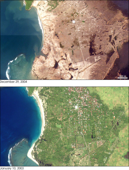
Perhaps the most devastation from the tsunami occurred in Indonesia. This is an image of the town of Lhoknga, Indonesia. It was completely wiped off the map by the tsunami, except for the white mosque in the center of town.
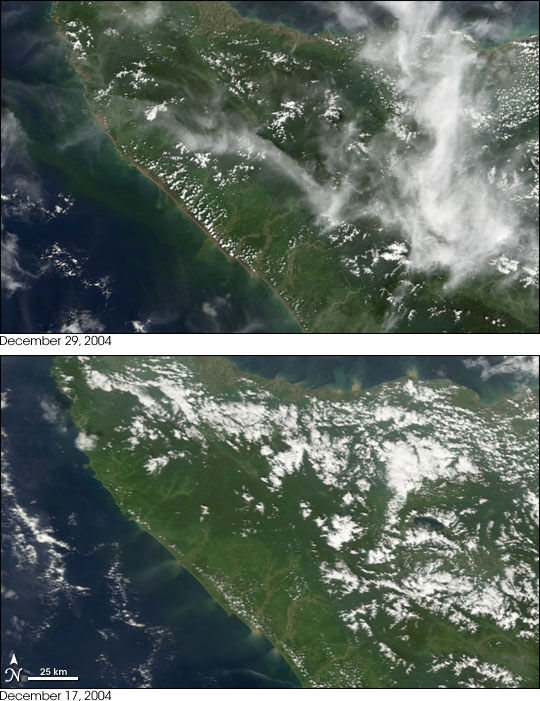
This photograph, captured by NASA’s Terra satellite shows how the whole northwest coast of the island of Sumatra was hit hard by the tsunami. It looks like the vegetation was just scraped back from the edge of the island.
We have written many articles about the devastation from the 2004 tsunami. Here’s an article about how GPS could be used for a tsunami warning system.
You can get many more tsunami pictures from NASA from their Earth observation page.
Recent Posts
More Evidence for the Gravitational Wave Background of the Universe
The gravitational wave background was first detected in 2016. It was announced following the release…
When Uranus and Neptune Migrated, Three Icy Objects Were Crashing Into Them Every Hour!
The giant outer planets haven’t always been in their current position. Uranus and Neptune for…

Astronomers Discover the Second-Lightest “Cotton Candy” Exoplanet to Date.
The hunt for extrasolar planets has revealed some truly interesting candidates, not the least of…
Did Earth’s Multicellular Life Depend on Plate Tectonics?
How did complex life emerge and evolve on the Earth and what does this mean…
Hubble Sees a Brand New Triple Star System
In a world that seems to be switching focus from the Hubble Space Telescope to…
The Venerable Hubble Space Telescope Keeps Delivering
The world was much different in 1990 when NASA astronauts removed the Hubble Space Telescope…