
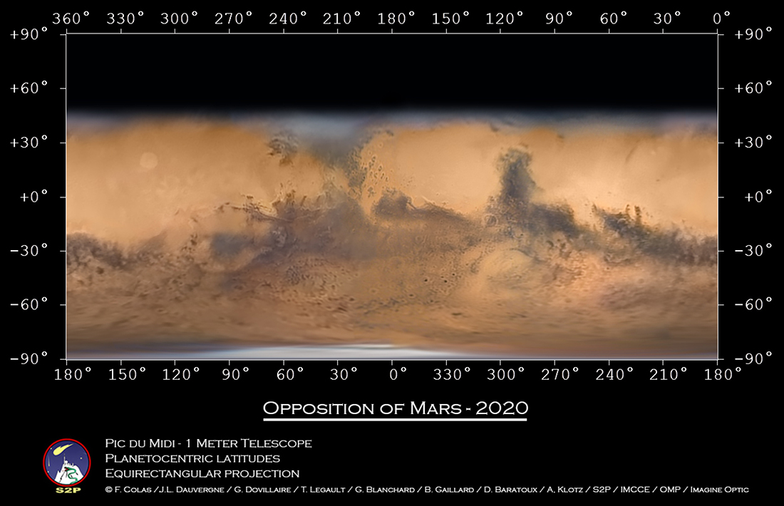
A group of amateur and professional astronomers have collaborated to create what may be the highest resolution global map of Mars ever created with images taken from Earth.
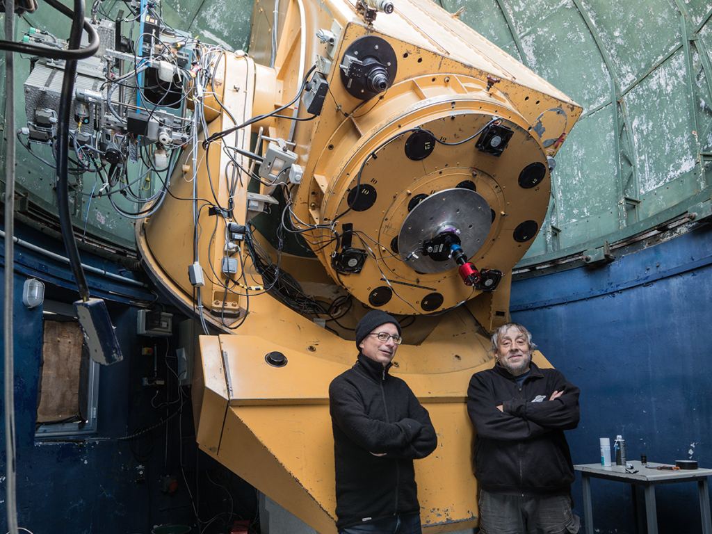
The images were taken with the 1-meter telescope at the Pic-du-Midi observatory in the Pyrenees of France, during several nights in October and November, 2020 when Mars was at opposition, or its closest approach to Earth.
“The team went to the observatory for a first mission from October 7-18, 2020,” noted amateur astrophotographer Thierry Legault told Universe Today. “The weather was not very good (lots of clouds and even snow) and seeing was unsatisfactory. But we recorded several videos, and they helped later to fill gaps in the global (360°) map of Mars.”
In hopes of adding additional data to their imagery, Legault continued to monitor the weather forecast and proposed to François Colas (astronomer at the Observatory of Paris, in charge of the Pic-du-Midi 1-meter telescope) to go for a second mission from October 29th to November 2nd.

“We drove from Paris to Pyrenees the day before the French re-confinement [lockdown due to the pandemic] and took one of the last cable cars” up to the summit observatory, Legault said. “We never got the outstanding seeing that happens sometimes there, but constantly monitoring the images, we were able to get about one hour of good videos over the 4 nights.”
With all the imagery, the astronomers were able to create the map, which “is a new milestone for ground based observatories,” said Legault.
But the wealth of data meant they could also create a rotating “planisphere” version, as well as dual version, where viewers can use the cross-eye technique to see Mars in 3-D:
For best results, use the highest resolution (720p) and use the full-screen version. If you’re using your phone, turn your phone sideways (horizontal). Relax your eyes – almost allowing them to cross, and a third version of Mars should pop up in the middle in thrilling 3-D. If that doesn’t work, Legault offered two other techniques:
- If you don’t have luck with the cross-eyed technique, try squinting to merge the two globes into one at the center of the frame. A finger or any thin object in front of your nose can help.
- Try the parallel technique: use two rolls of paper or cardboard, held like binoculars. This can help to direct each eye towards the corresponding globe (left eye for the left globe, right eye for the right globe).
Image processing tools were key to creating such clear and striking images. Legault said Jean-Luc Dauvergne worked incredibly hard using on the processing, using Autostakkert (for image selection and stacking) and Winjupos (for the combination of images taken at different moments and finally the map).
It was during the processing when Dauvergne realized that with all the imagery, the entire surface of Mars had been imaged, meaning that a global map could be made from the data.
The entire team who worked on gathering images and processing them includes Legault, Colas, Dauvergne, G. Dovillaire, G. Blanchard, B. Gaillard, D. Baratoux, and A. Klotz.
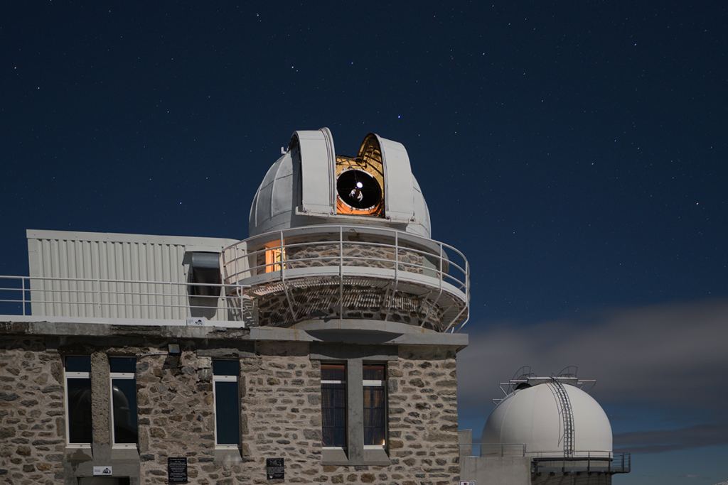
The Pic du Midi observatory is located on top of the Pic du Midi de Bigorre in the French Pyrenees, at 2,877 meters (9,400 ft.) elevation. Construction on the observatory began in 1878, and the observatory has produced some of the best images of other planets, taken from ground-based telescopes. In the 1960s, NASA funded the installation of the 1-meter telescope in order to help produce a photographic atlas of the Moon, to help prepare for the Apollo missions.
Our thanks — as always — to Thierry Legault for sharing his insights and images. See more of his amazing work at his website, as well as on Facebook and Twitter.