Satellite Images of China Earthquake
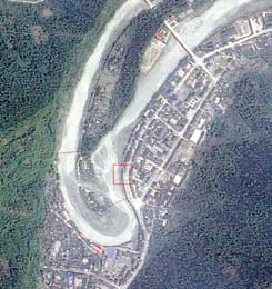
Some of the first satellite images have been released of areas in China hit by the 7.9 magnitude earthquake on May 12, 2008. This image shows Beichuan, one of the worst-hit areas in Sichuan Province of southwest China. The pictures reveal a large forest, a school and clusters of residential houses along a river that has been destroyed out by the quake. A road along the river was also severely damaged. The images were taken by Taiwan’s FORMOSAT-2 satellite. A “before” image is also available, taken in two years ago in May of 2006:
The pictures are expected to be used as references in China’s efforts in searching and rescuing people still missing in Sichuan.
Harry Chang, a professor of National Taiwan Normal University said the images have been given to the Chinese Academy of Sciences. Chang said that in Beichuan, the earthquake also caused landslides, evident in the top photo, covering some 1,500 hectares (3,705 acres), which had blocked the river.
“Accordingly, several new lakes have been formed. What is dangerous is that should the new lakes burst, the residents living in the low-lying areas of the river would be in danger,” he said.
Chang also warned of mudslides caused by rain, saying “it would make the rescue work more difficult.” As of May 15, officials estimated the death toll could reach 50,000.
Monday’s earthquake began at 2:28 p.m. local time (06:28 UTC). The quake was felt throughout much of China, as well as parts of Taiwan, Thailand, and Vietnam. This elevation map above shows the region where the earthquake struck. Green indicates the lowest elevations, and beige the highest. The data for this map were collected by NASA’s Shuttle Radar Topography Mission (SRTM) in 2000. Overlain onto the map are earthquake magnitude indicators. The earthquake’s epicenter was approximately 90 kilometers (55 miles) west-northwest of the city of Chengdu. Smaller magnitude events occurred northeast of the epicenter, and generally followed the edge of the Longmen Shan mountain range.
Original News Sources: The China Post, NASA Earth Observatory
Recent Posts
Starlink on Mars? NASA Is Paying SpaceX to Look Into the Idea
NASA has given the go-ahead for SpaceX to work out a plan to adapt its…
Did You Hear Webb Found Life on an Exoplanet? Not so Fast…
The JWST is astronomers' best tool for probing exoplanet atmospheres. Its capable instruments can dissect…

Vera Rubin’s Primary Mirror Gets its First Reflective Coating
First light for the Vera Rubin Observatory (VRO) is quickly approaching and the telescope is…
Two Stars in a Binary System are Very Different. It's Because There Used to be Three
A beautiful nebula in the southern hemisphere with a binary star at it's center seems…
The Highest Observatory in the World Comes Online
The history of astronomy and observatories is full of stories about astronomers going higher and…
Is the JWST Now an Interplanetary Meteorologist?
The JWST keeps one-upping itself. In the telescope's latest act of outdoing itself, it examined…