Curiosity Finds A Region of Ancient Dried Mud. It Could Have Been an Oasis Billions of Year Ago

This Martian rock slab is called "Old Soaker." It may have formed more than 3 billion years ago when a mud layer dried out. The cracks indicate alternating periods of dryness and wetness. Image Credit: NASA/JPL-Caltech/MSSS

What happened to Mars? If Mars and Earth were once similar, as scientists think, what happened to all the water? Did there used to be enough to support life?

Thanks to the Mars Science Laboratory (MSL) Curiosity, we’re getting a better picture of ancient Mars and what it went through billions of years ago. A new study published in Nature Geoscience says that Mars likely underwent alternating periods of wet and dry, before becoming the frigid, dry desert it is now. Or at least, Gale Crater did.

Continue reading “Curiosity Finds A Region of Ancient Dried Mud. It Could Have Been an Oasis Billions of Year Ago”

Curiosity has Found the Mother Lode of Clay on the Surface of Mars

Curiosity at Mt. Sharp, Gale Crater, Mars. To the left of the rover are two drill holes into the rocks "Aberlady" and "Kilmarie." Curiosity found high concentrations of clay in both rocks. Image Credit: NASA/JPL-Caltech/MSSS

Clay is a big deal on Mars because it often forms in contact with water. Find clay, and you’ve usually found evidence of water. And the nature, history, and current water budget on Mars are all important to understanding that planet, and if it ever supported life.

Continue reading “Curiosity has Found the Mother Lode of Clay on the Surface of Mars”

Curiosity’s First 360-Degree Color Panorama

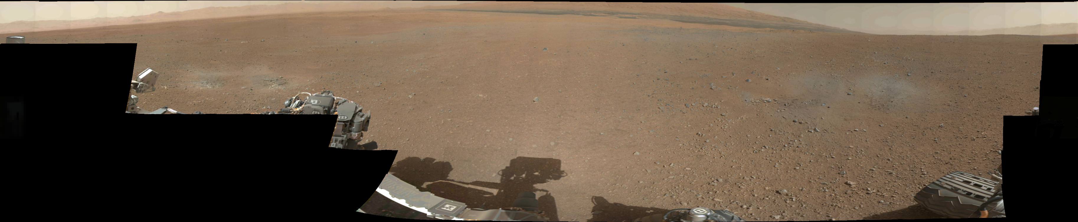
Doesn’t Gale Crater look lovely this time of year? This is the first 360-degree panorama of color images taken by Curiosity’s color Mast Camera. The individual images used in this first panorama may only have been thumbnail-sized, but the effect is no less stunning.

(Click the image to panoramify.)

 The images were acquired on August 9 EDT. Although taken during late afternoon at Gale crater, the individual images still had to be brightened as Mars only receives half the amount of sunlight that Earth does.

Full-size 1200×1200 pixel images will be available at a later date.

The two grey patches in the foreground at left and right are the result of Curiosty’s sky crane rockets blasting the Martian surface. Scientists will be investigating these areas as they expose material that was previously hidden beneath Mars’ red dust.

The base of Gale Crater’s 3.4-mile (5.5 km) high central peak, named Mt. Sharp in honor of planetary science pioneer Robert P. Sharp, can be seen in the distance at center. (Check out an oblique view of a portion of Mt. Sharp acquired by HiRISE camera here.)

You can play with an interactive 360-degree panorama at the NASATech website, put together by John O’Connor, and if you look closely, visible is the full JPL logo on the middle right wheel — in Morse Code!

As always, you can find more news from the MSL mission here.

Image: NASA/JPL-Caltech