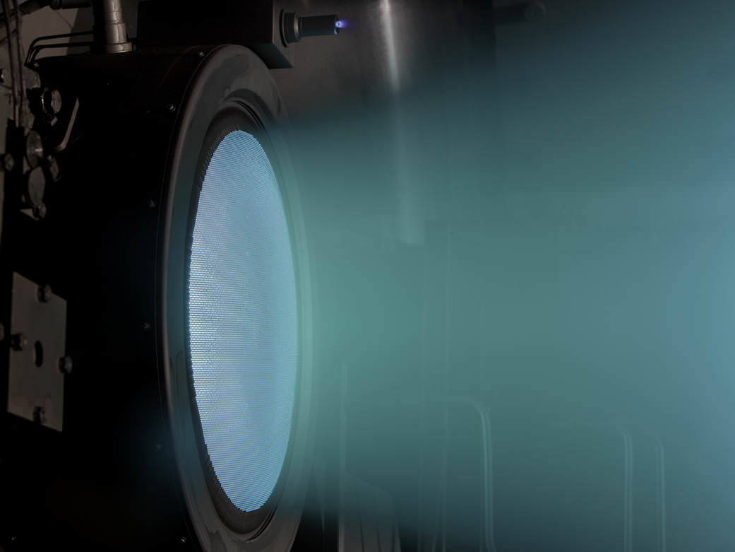
The comforting blue glow of an ion drive. Image Credit: NASA
When we think of space travel, we tend to picture a massive rocket blasting off from Earth, with huge blast streams of fire and smoke coming out the bottom, as the enormous machine struggles to escape Earth’s gravity. Rockets are our only option for escaping Earth’s gravity well—for now. But once a spacecraft has broken its gravitational bond with Earth, we have other options for powering them. Ion propulsion, long dreamed of in science fiction, is now used to send probes and spacecraft on long journeys through space.
NASA first began researching ion propulsion in the 1950’s. In 1998, ion propulsion was successfully used as the main propulsion system on a spacecraft, powering the Deep Space 1 (DS1) on its mission to the asteroid 9969 Braille and Comet Borrelly. DS1 was designed not only to visit an asteroid and a comet, but to test twelve advanced, high-risk technologies, chief among them the ion propulsion system itself.
Ion propulsion systems generate a tiny amount of thrust. Hold nine quarters in your hand, feel Earth’s gravity pull on them, and you have an idea how little thrust they generate. They can’t be used for launching spacecraft from bodies with strong gravity. Their strength lies in continuing to generate thrust over time. This means that they can achieve very high top speeds. Ion thrusters can propel spacecraft to speeds over 320,000 kp/h (200,000 mph), but they must be in operation for a long time to achieve that speed.
An ion is an atom or a molecule that has either lost or gained an electron, and therefore has an electrical charge. So ionization is the process of giving a charge to an atom or a molecule, by adding or removing electrons. Once charged, an ion will want to move in relation to a magnetic field. That’s at the heart of ion drives. But certain atoms are better suited for this. NASA’s ion drives typically use xenon, an inert gas, because there’s no risk of explosion.
Detail of an ion drive. Image: NASA Glenn Research Center. Vectorization by Chabacano
In an ion drive, the xenon isn’t a fuel. It isn’t combusted, and it has no inherent properties that make it useful as a fuel. The energy source for an ion drive has to come from somewhere else. This source can be electricity from solar cells, or electricity generated from decay heat from a nuclear material.
Ions are created by bombarding the xenon gas with high energy electrons. Once charged, these ions are drawn through a pair of electrostatic grids—called lenses—by their charges, and are expelled out of the chamber, producing thrust. This discharge is called the ion beam, and it is again injected with electrons, to neutralize its charge. Here’s a short video showing how ion drives work:
Unlike a traditional chemical rocket, where its thrust is limited by how much fuel it can carry and burn, the thrust generated by an ion drive is only limited by the strength of its electrical source. The amount of propellant a craft can carry, in this case xenon, is a secondary concern. NASA’s Dawn spacecraft used only 10 ounces of xenon propellant—that’s less than a soda can—for 27 hours of operation.
NASA Evolutionary Xenon Thruster. Image Credit: NASA
In theory, there is no limit to the strength of the electrical source powering the drive, and work is being done to develop even more powerful ion thrusters than we currently have. In 2012, NASA’s Evolutionary Xenon Thruster (NEXT) operated at 7000w for over 43,000 hours, in comparison to the ion drive on DS1 that used only 2100w. NEXT, and designs that will surpass it in the future, will allow spacecraft to go on extended missions to multiple asteroids, comets, the outer planets, and their moons.
Missions using ion propulsion include NASA’s Dawn mission, the Japanese Hayabusa mission to asteroid 25143 Itokawa, and the upcoming ESA missions Bepicolombo, which will head to Mercury in 2017, and LISA Pathfinder, which will study low frequency gravitational waves.
With the constant improvement in ion propulsion systems, this list will only grow.
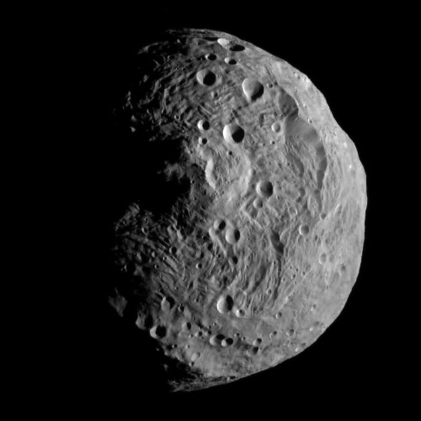
The planetoid Vesta, which was studied by the Dawn probe between July 2011 and September 2012. Credit: NASA
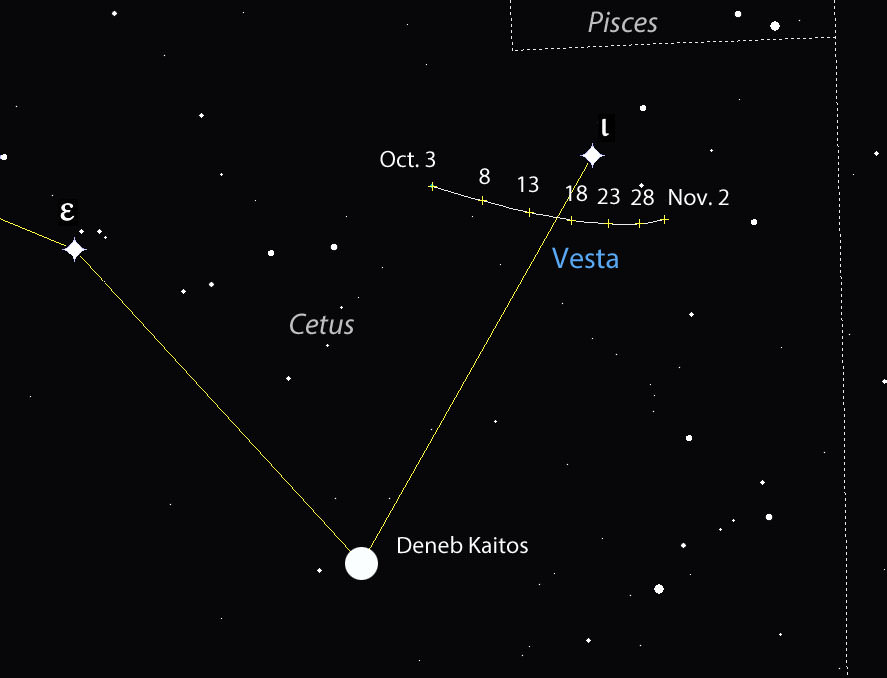
The brightest asteroid visible from Earth prowls across Cetus the Whale this month. Vesta shines at magnitude +6.3, right at the naked eye limit for observers with pristine skies, but easily coaxed into view with any pair of binoculars. With the moon now gone from the evening sky, you can start your search tonight.
Facing southeast around 10 p.m. local time in early October. 4 Vesta — its formal designation as the fourth asteroid discovered — travels along a short arc south of the easily-found star, Iota Ceti. Shoot a line from the Square of Pegasus south to arrive at Deneb Kaitos, Cetus’ brightest star, and from their to Iota Ceti and Vesta. Detailed map below. Source: Stellarium
Vesta came to opposition on September 28 and remains well-placed for viewing through early winter. Today’s it’s 134 million miles (225 million km) from Earth or about 5 million miles farther the Mars’ average distance from us. Although it’s one of the largest asteroids in the inner asteroid belt between Mars and Jupiter with a diameter of 326 miles (525 km), it never appears larger than a point of light even in many professional telescopes. Your binocular view will be as satisfying as the one through Mt. Palomar.
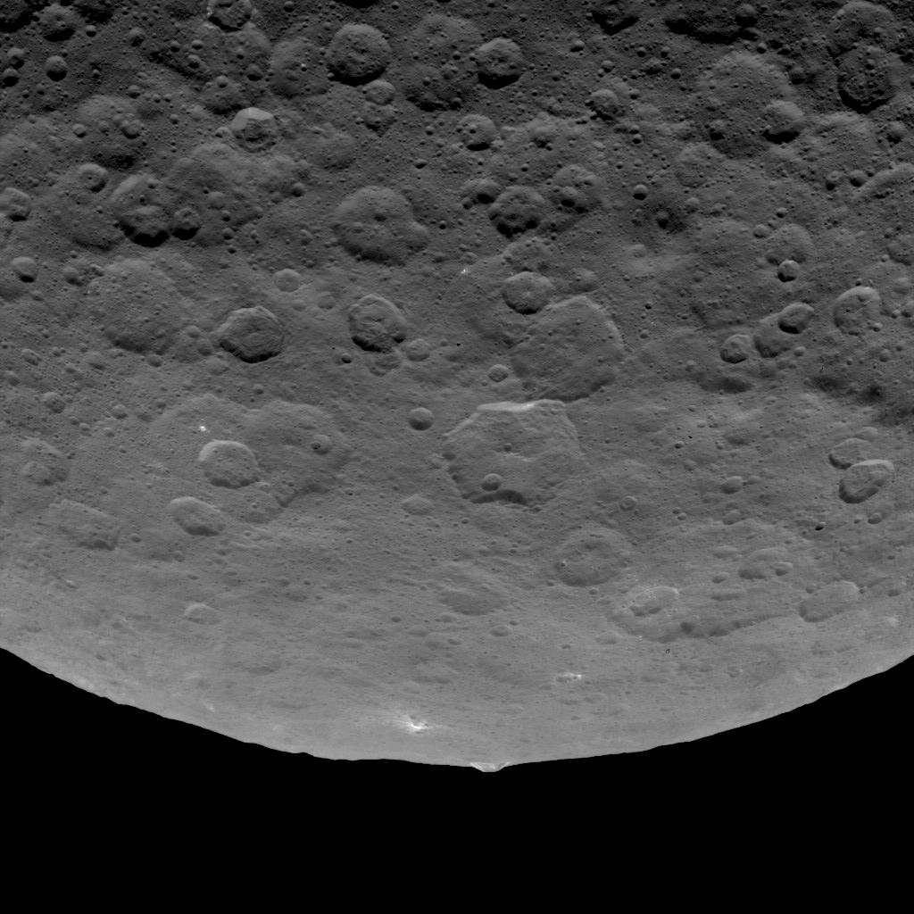
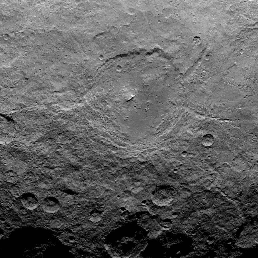
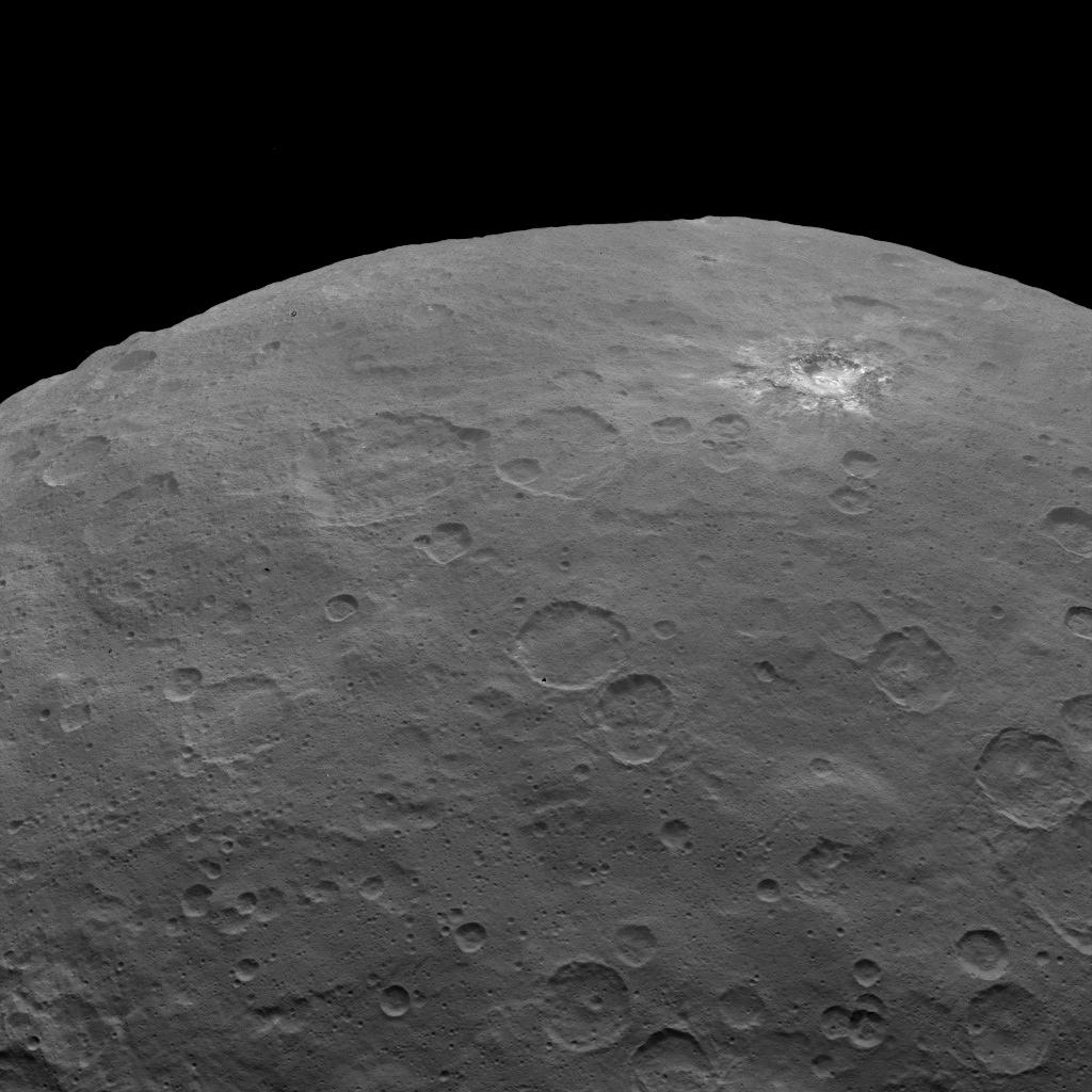
Like an inverted belly button, a spectacular central peak more than 14 miles high rises from the 310-mile-wide crater Rheasilvia. Credit: NASA
Discovered by the German astronomer Heinrich Olbers in March 1807, Vesta was named for the Roman goddess of home and hearth. NASA’s Dawn spacecraft, currently in orbit around another asteroid, Ceres, visited Vesta between July 2011 and September 2012, taking thousands of close-up images and measuring the mineral make-up of its soil and crust. We learned a few things while we were there:
Vesta is differentiated into crust, mantle and core just like the bigger planets are. That’s why you’ll sometimes hear it described as a “protoplanet”, the first of its kind discovered in our solar system.
A class of igneous meteorites fallen to Earth called Howardites, eucrites and diogenites (HED-meteorites) were confirmed as actual pieces of the asteroid that found their way here after being blasted into space by impact.
Some of the meteorites / rocks that pelted the asteroid from elsewhere in the solar system are water-rich.
Vesta’s covered in craters like the moon
A staggering-large 310-mile-wide (500 km) impact crater named Rheasilvia marks its south pole. The basin’s central peak rises to 14.3 miles (23 km), more than twice the height of Mt. Everest.
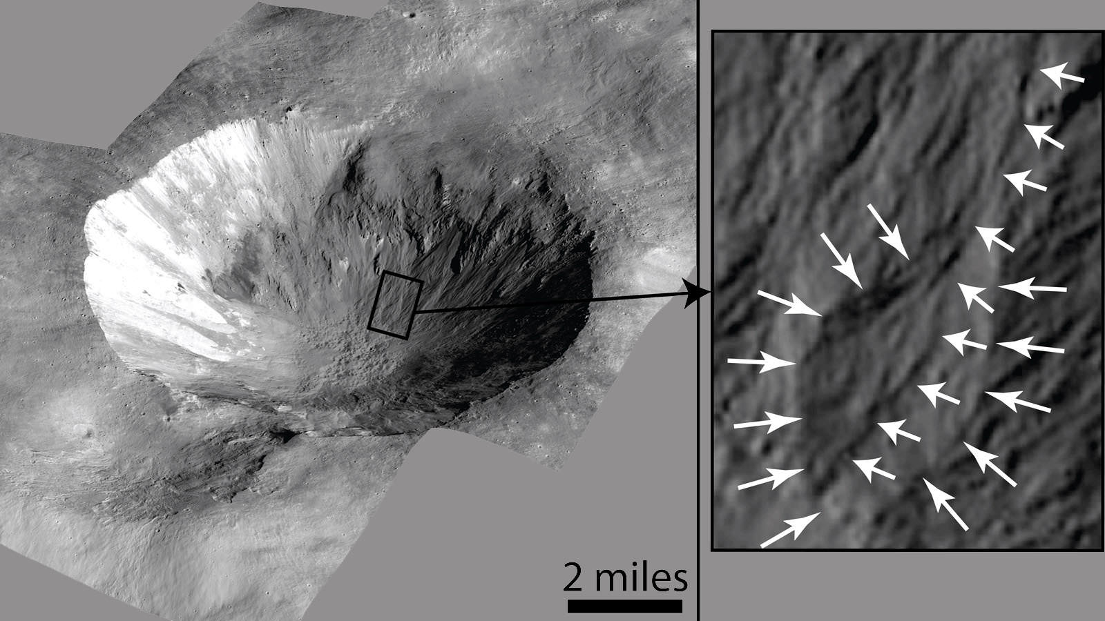
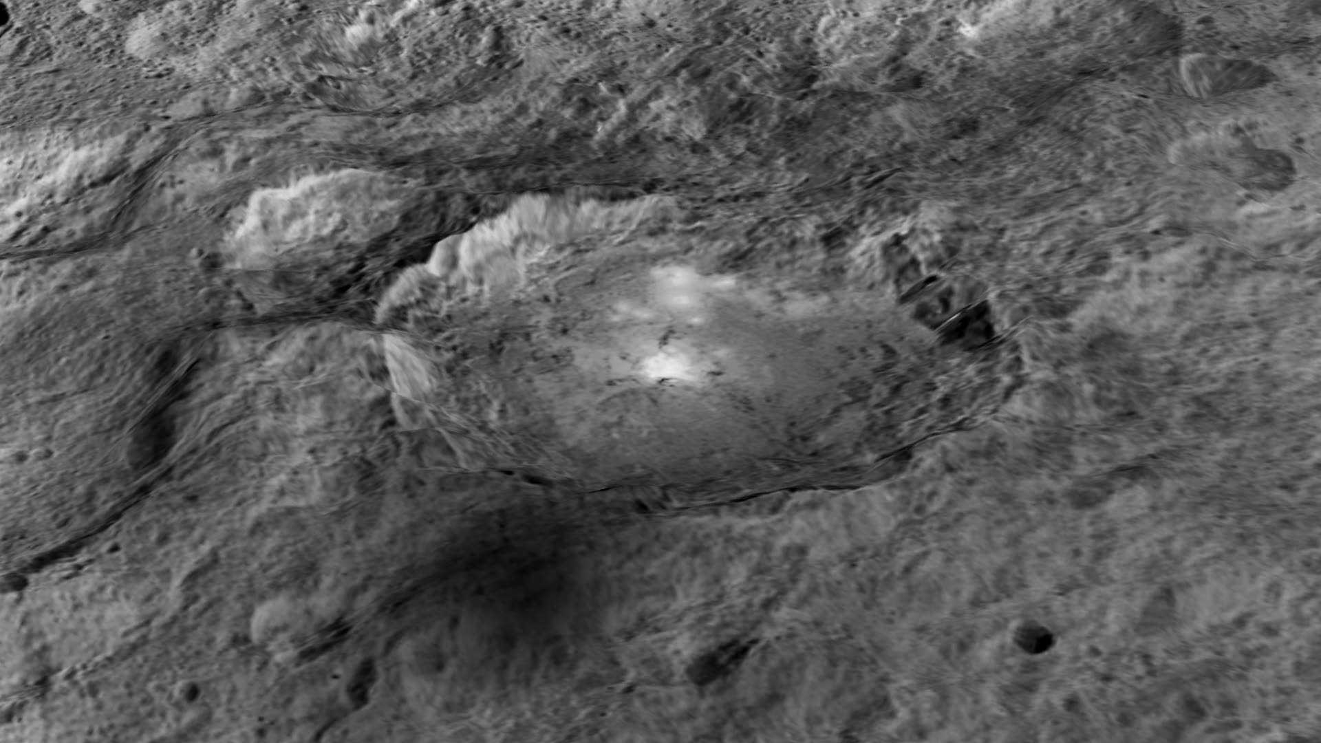
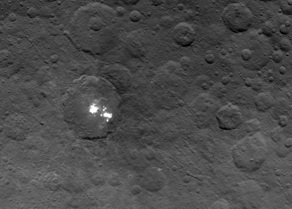
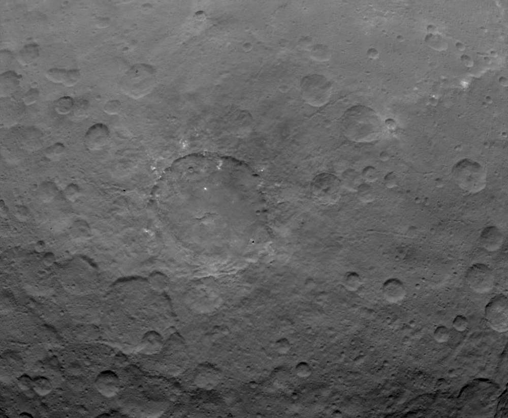
Cornelia Crater on the asteroid Vesta. The crater is about 4 to 5 million years old. On the right is an inset image showing an example of curved gullies that may have been carved by water, indicated by the short white arrows, and a fan-shaped deposit, indicated by long white arrows. The inset image is about 0.62 miles (1 km) wide. Credit: NASA/JPL-Caltech/UCLA/MPS/DLR/IDA
You can see it all in your mind’s eye the next clear night. For skywatchers at mid-northern latitudes, Vesta climbs into good view around 10 o’clock in early October and 8 o’clock by month’s end. If you’re familiar with gangly Cetus, you can start with the 2nd magnitude star Deneb Kaitos, the brightest star in the constellation. If not, begin your Vestan voyage from the Great Square in Pegasus, high in the southeastern sky.
Once you’ve arrived at Deneb Kaitos, locate Iota Ceti, 10 degrees to the northwest. The star makes finding Vesta easy in binoculars this month. Stars shown to magnitude +7. North is up and the asteroid’s position is marked every 5 days at 10 p.m. Vesta fades slowly during the month to mag. 6.8 by Nov. 1. CDT. Source: Chris Marriott’s SkyMap software
Drop a line through the two stars along the left side of the Square and continue it down toward the southern horizon. You’ll run right into DK. Now elevate your gaze — or aim your binoculars — one outstretched fist (10°) or about two binocular fields of view above and right of Deneb Kaitos to find Iota Ceti (mag. 3.6).
Once you’ve got Iota, the asteroid will be in your field of view close by. Use the detailed chart to pinpoint its location with respect to Iota. Easy, right? Well, I hope so. Bon voyage to Vesta!
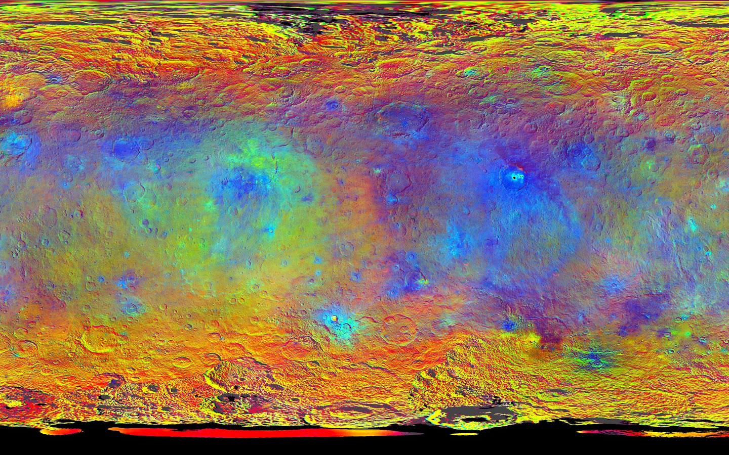
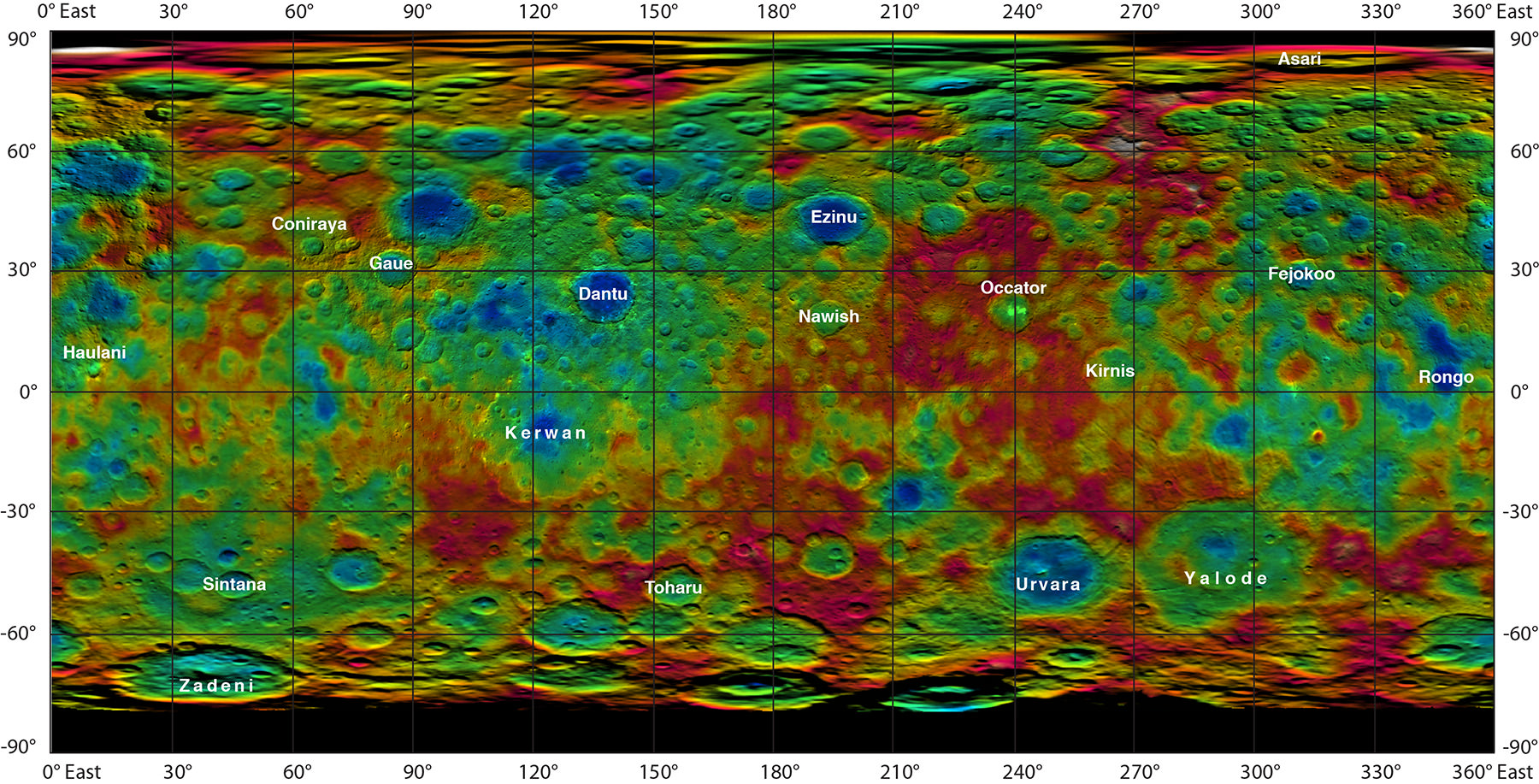
This map-projected view of Ceres was created from images taken by NASA's Dawn spacecraft during its high-altitude mapping orbit, in August and September, 2015. This color coded map can provide valuable insights into the mineral composition of the surface, as well as the relative ages of surface features. Credits: NASA/JPL-Caltech/UCLA/MPS/DLR/IDA
Slowly but surely the mysteries of dwarf planet Ceres are being peeled back layer by layer as NASA’s Dawn spacecraft orbits lower and lower and gathers detailed measurements that have now yielded global mineral and topographic maps, tantalizing researchers with the best resolution ever.
The Dawn science team has been painstakingly stitching together the spectral and imaging products captured from the lowest orbit yet achieved into high resolution global maps of Ceres, released today Sept. 30, by NASA.
“Ceres continues to amaze, yet puzzle us, as we examine our multitude of images, spectra and now energetic particle bursts,” said Chris Russell, Dawn principal investigator at the University of California, Los Angeles, in a statement.
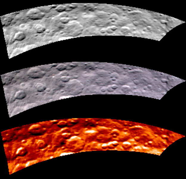
The color coded map above is providing researchers with valuable insights into the mineral composition of Ceres surface, as well as the relative ages of the surface features that were a near total mystery until Dawn arrived on March 6, 2015.
The false-color mineral map view combines images taken using infrared (920 nanometers), red (750 nanometers) and blue (440 nanometers) spectral filters.
“Redder colors indicate places on Ceres’ surface that reflect light strongly in the infrared, while bluish colors indicate enhanced reflectivity at short (bluer) wavelengths; green indicates places where albedo, or overall brightness, is strongly enhanced,” say officials.
“Scientists use this technique in order to highlight subtle color differences across Ceres, which would appear fairly uniform in natural color. This can provide valuable insights into the mineral composition of the surface, as well as the relative ages of surface features.”
Researchers say the mineral variations at Ceres “are more subtle than on Vesta, Dawn’s previous port of call.”
The asteroid Vesta was Dawn’s first orbital target and conducted extensive observations of the bizarre world for over a year in 2011 and 2012.
The Dawn team is meeting this week to review and publish the mission results so far at the European Planetary Science Conference in Nantes, France.
Dawn is Earth’s first probe in human history to explore any dwarf planet, the first to explore Ceres up close and the first to orbit two celestial bodies.
Ceres is a Texas-sized world, ranks as the largest object in the main asteroid belt between Mars and Jupiter, and may have a subsurface ocean of liquid water that could be hospitable to life.
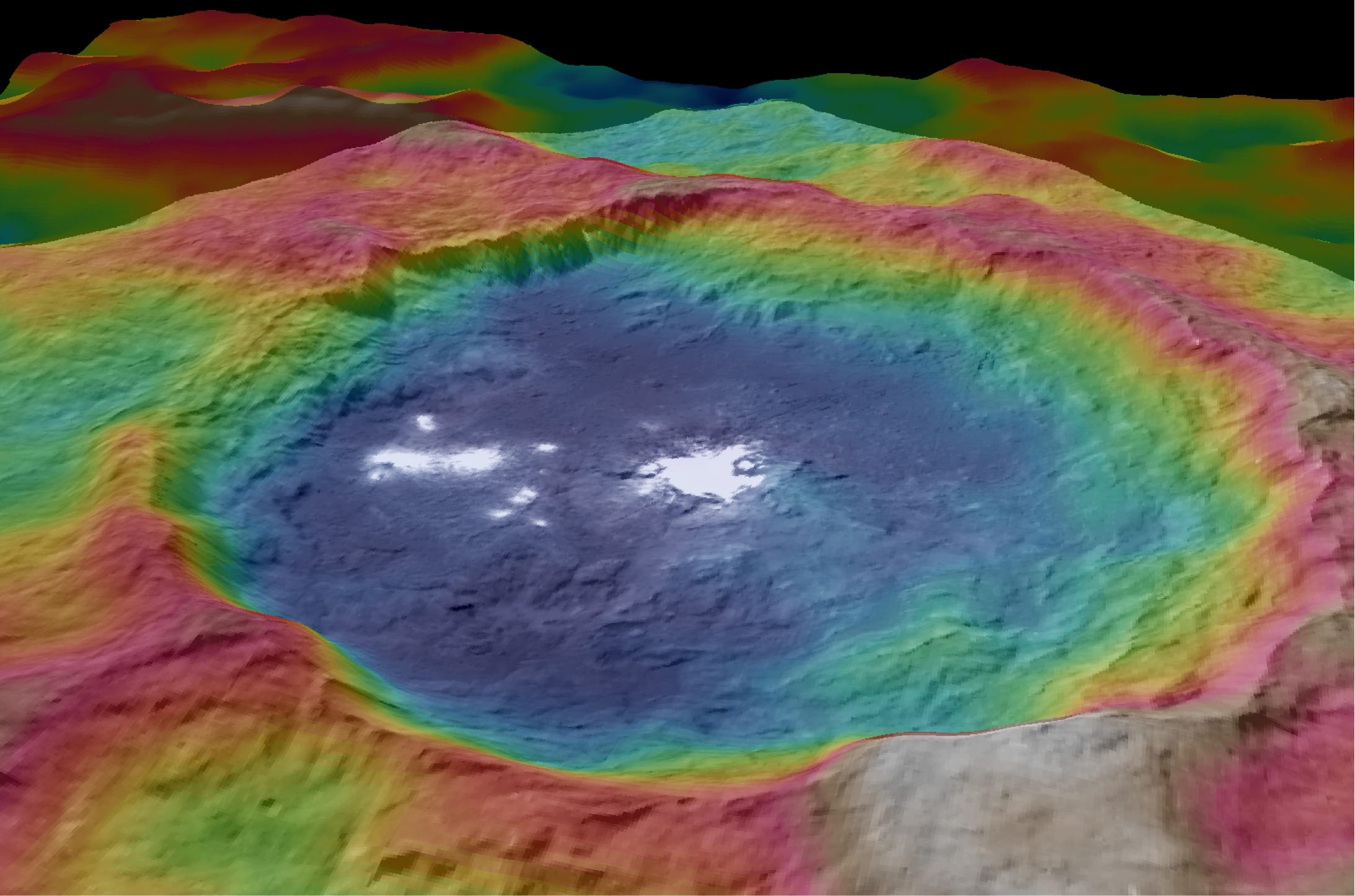
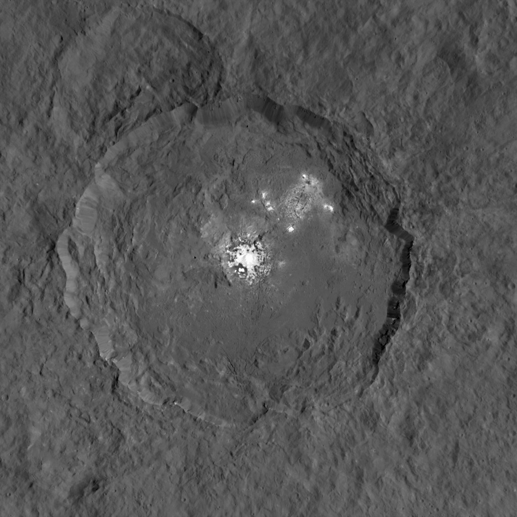
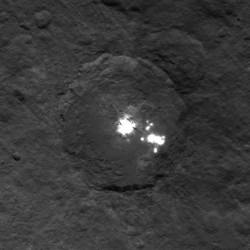
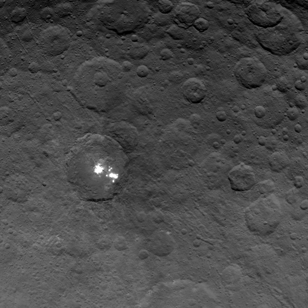
This view from NASA’s Dawn spacecraft is a color-coded topographic map of Occator crater on Ceres. Blue is the lowest elevation, and brown is the highest. The crater, which is home to the brightest spots on Ceres, is approximately 56 miles (90 kilometers wide). Credits: NASA/JPL-Caltech/UCLA/MPS/DLR/IDA
The newly released maps were created from data gathered at Dawn’s current science orbit, known as the High Altitude Mapping Orbit (HAMO) phase of the mission, during August and September.
At HAMO, Dawn is circling Ceres at an altitude of barely 915 miles (1,470 kilometers) above the heavily cratered surface.
“Dawn arrived in this third mapping orbit [HAMO] on Aug. 13. It began this third mapping phase on schedule on Aug. 17,” Dr. Marc Rayman, Dawn’s chief engineer and mission director based at NASA’s Jet Propulsion Laboratory, Pasadena, California, told Universe Today.
Each HAMO mapping orbit cycle lasts 11 days and consists of 14 orbits lasting 19 hours each. Ceres is entirely mapped during each of the 6 cycles. The third mapping cycle started on Sept. 9.
Dawn’ instruments, including the Framing Camera and Visible and Infrared Spectrometer (VIR) will be aimed at slightly different angles in each mapping cycle allowing the team to generate stereo views and construct 3-D maps.
“The emphasis during HAMO is to get good stereo data on the elevations of the surface topography and to get good high resolution clear and color data with the framing camera,” Russell told me.
“We are hoping to get lots of VIR IR data to help understand the composition of the surface better.”
“Dawn will use the color filters in its framing camera to record the sights in visible and infrared wavelengths,” notes Rayman.
The new maps at HAMO provide about three times better resolution than the images captured from its previous orbit in June, and nearly 10 times better than in the spacecraft’s initial orbit at Ceres in April and May.
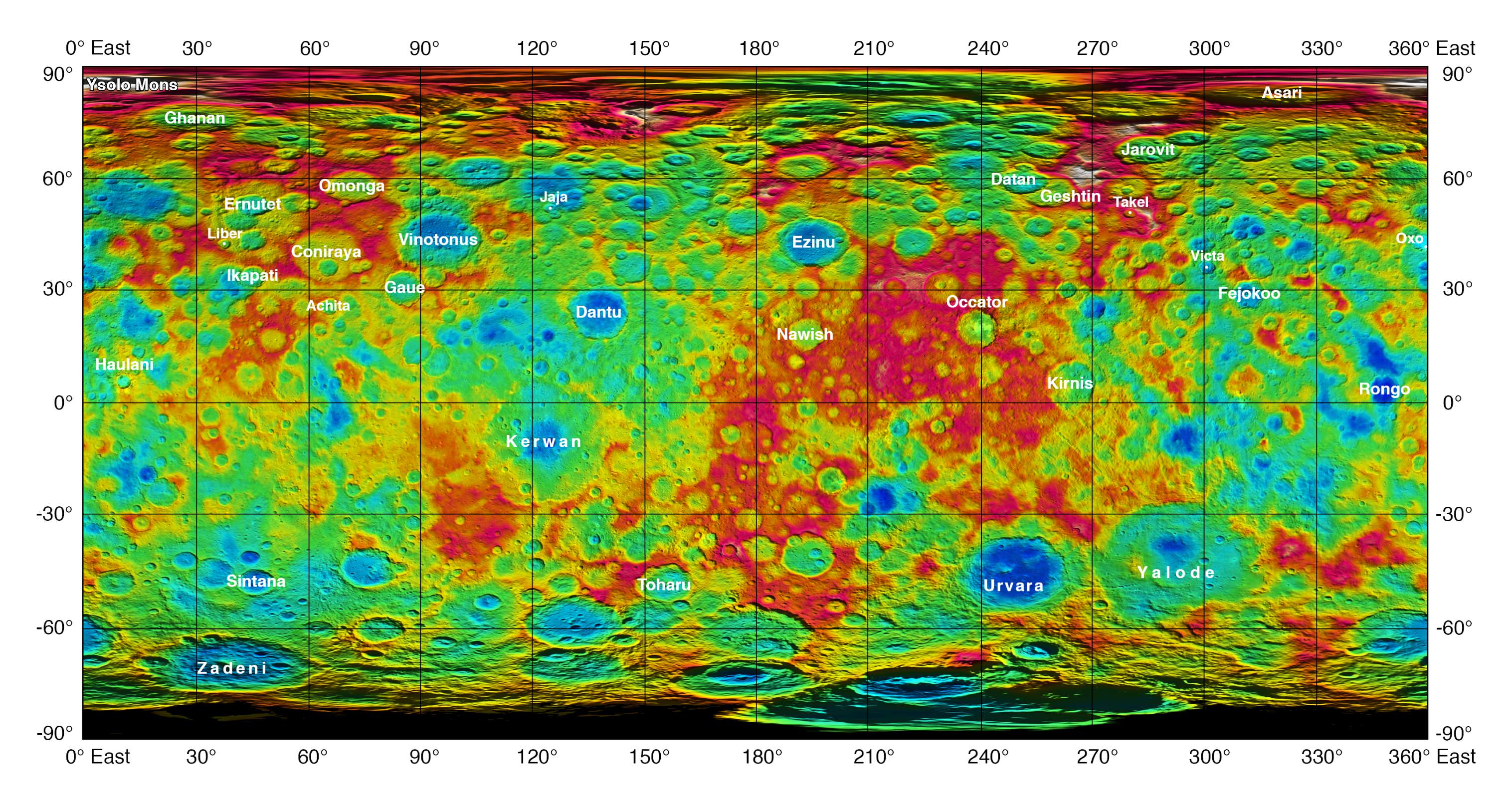
This color-coded map from NASA’s Dawn shows the highs and lows of topography on the surface of dwarf planet Ceres. It is labeled with names of features approved by the International Astronomical Union. The color scale extends about 5 miles (7.5 kilometers) below the reference surface in indigo to 5 miles (7.5 kilometers) above the reference surface in white. Credits: NASA/JPL-Caltech/UCLA/MPS/DLR/IDA
The science team also released a new color-coded topographic map annotated with over a dozen Cerean feature names recently approved by the IAU.
“The names for features on Ceres are all eponymous for agricultural spirits, deities and festivals from cultures around the world. These include Jaja, after the Abkhazian harvest goddess, and Ernutet, after the cobra-headed Egyptian harvest goddess. A 12-mile (20-kilometer) diameter mountain near Ceres’ north pole is now called Ysolo Mons, for an Albanian festival that marks the first day of the eggplant harvest.”
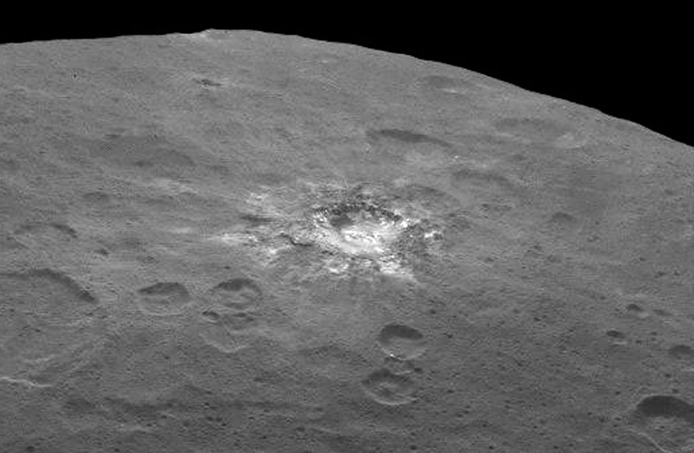
The biggest Cerean mystery of all remains the nature of the bright spots at Occator crater. It’s still under analysis and the team released a new color coded topographic map.
The imagery and other science data may point to evaporation of salty water as the source of the bright spots.
“Occasional water leakage on to the surface could leave salt there as the water would sublime,” Russell told me.
“The big picture that is emerging is that Ceres fills a unique niche,” Prof. Chris Russell, Dawn principal investigator told Universe Today exclusively.
“Ceres fills a unique niche between the cold icy bodies of the outer solar system, with their rock hard icy surfaces, and the water planets Mars and Earth that can support ice and water on their surfaces,” said Russell.
“The irregular shapes of craters on Ceres are especially interesting, resembling craters we see on Saturn’s icy moon Rhea,” says Carol Raymond, Dawn’s deputy principal investigator based at NASA’s Jet Propulsion Laboratory, Pasadena, California. “They are very different from the bowl-shaped craters on Vesta.”
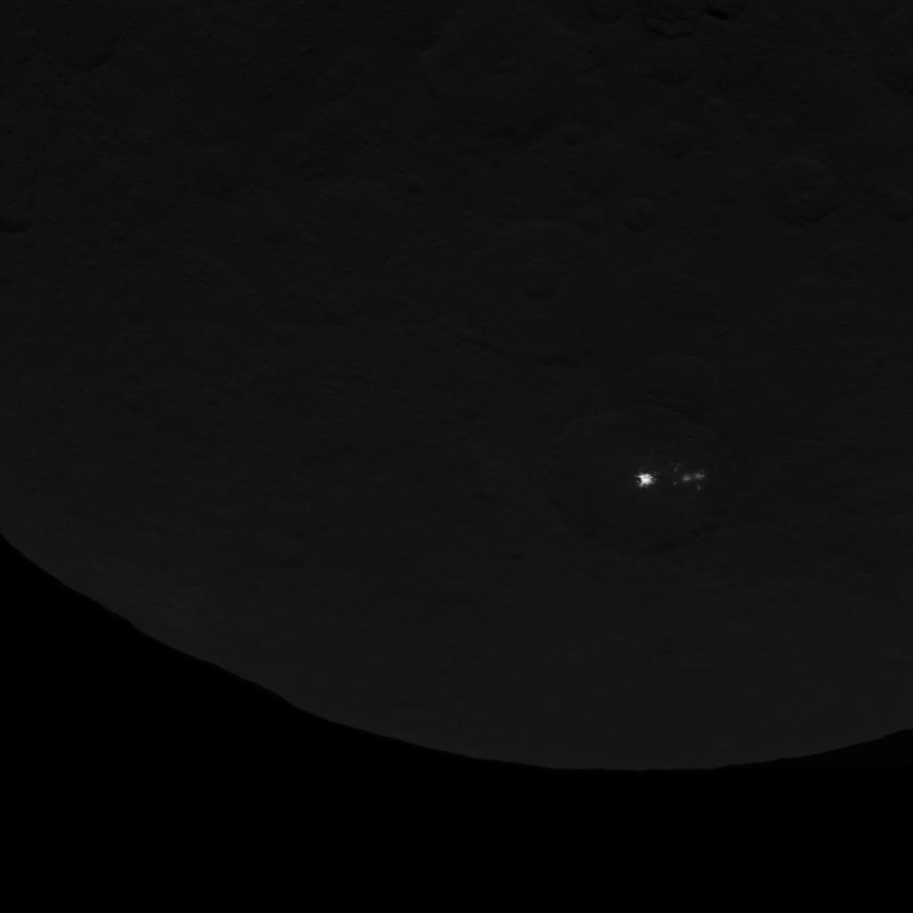
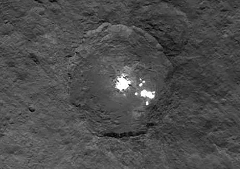
This image was taken by NASA’s Dawn spacecraft of dwarf planet Ceres on Feb. 19 from a distance of nearly 29,000 miles (46,000 km). It shows that the brightest spot on Ceres has a dimmer companion, which apparently lies in the same basin. See below for the wide view. Credit: NASA/JPL-Caltech/UCLA/MPS/DLR/IDA
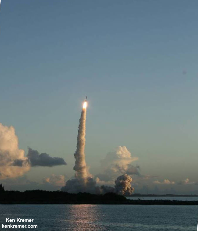
Dawn was launched on September 27, 2007 by a United Launch Alliance (ULA) Delta II Heavy rocket from Space Launch Complex-17B (SLC-17B) at Cape Canaveral Air Force Station, Florida.
Stay tuned here for Ken’s continuing Earth and planetary science and human spaceflight news.
This image, made using images taken by NASA’s Dawn spacecraft during the mission’s High Altitude Mapping Orbit (HAMO) phase, shows Occator crater on Ceres, home to a collection of intriguing bright spots. Credits: NASA/JPL-Caltech/UCLA/MPS/DLR/IDA
This image, made using images taken by NASA's Dawn spacecraft during the mission's High Altitude Mapping Orbit (HAMO) phase, shows Occator crater on Ceres, home to a collection of intriguing bright spots. Credits: NASA/JPL-Caltech/UCLA/MPS/DLR/IDA
This image, made using images taken by NASA’s Dawn spacecraft during the mission’s High Altitude Mapping Orbit (HAMO) phase, shows Occator crater on Ceres, home to a collection of intriguing bright spots. Credits: NASA/JPL-Caltech/UCLA/MPS/DLR/IDA
Story/imagery updated[/caption]
Since scientists believe that Ceres occupies a “unique niche” in the solar system and apparently harbors subsurface ice or liquid oceans, could the bright spots arise from subsurface “water leakage?” To find out Universe Today asked Dawn’s Principal Investigator and Chief Engineer.
“The big picture that is emerging is that Ceres fills a unique niche,” Prof. Chris Russell, Dawn principal investigator told Universe Today exclusively.
“Ceres fills a unique niche between the cold icy bodies of the outer solar system, with their rock hard icy surfaces, and the water planets Mars and Earth that can support ice and water on their surfaces,” said Russell, of the University of California, Los Angeles.
And with Dawn recently arrived at its second lowest science mapping orbit of the planned mission around icy dwarf planet Ceres in mid-August, the NASA spacecraft is capturing the most stunningly detailed images yet of those ever intriguing bright spots located inside Occator crater.
The imagery and other science data may point to evaporation of salty water as the source of the bright spots.
“Occasional water leakage on to the surface could leave salt there as the water would sublime,” Russell told me.
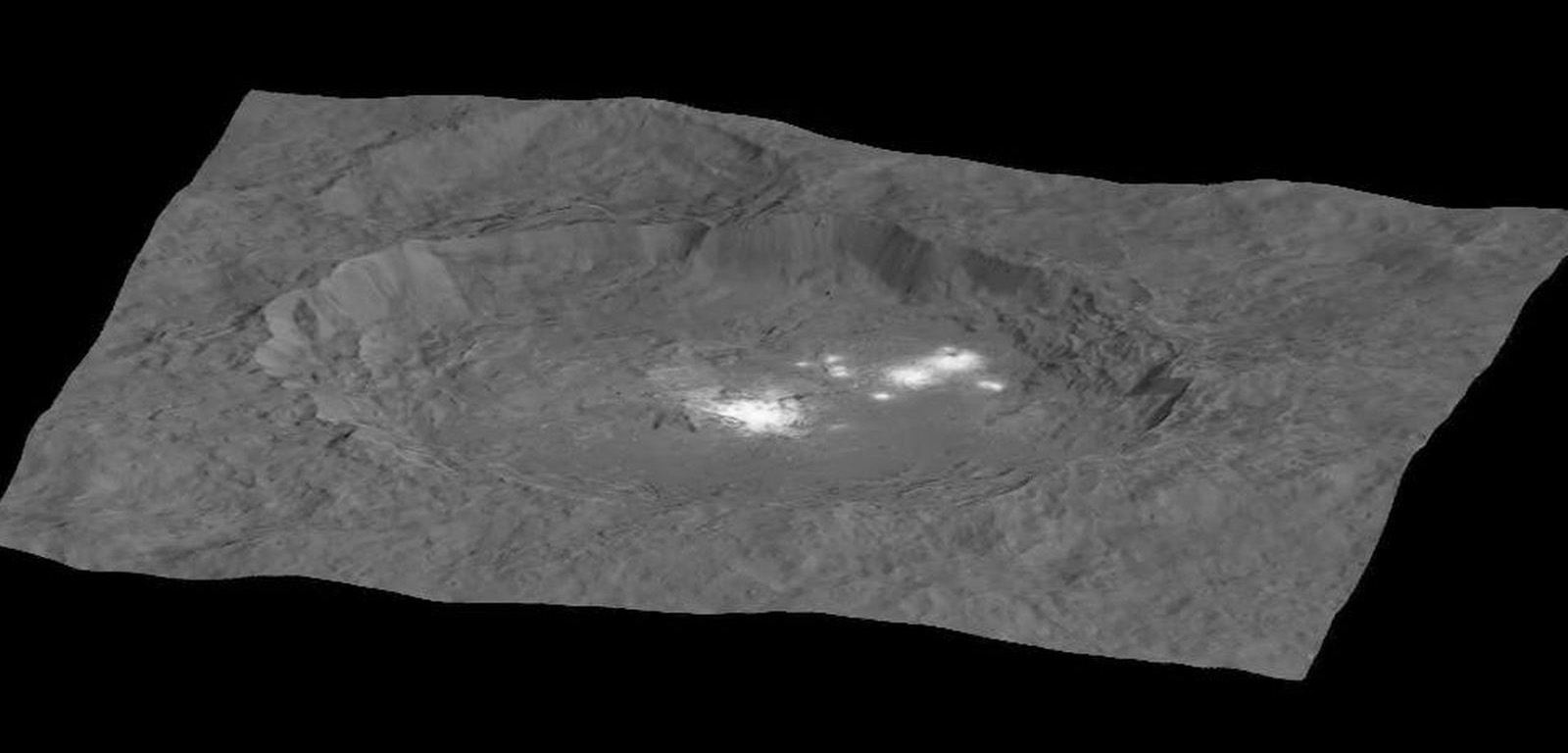
Circling the Lights of Occator crater on Ceres. This image, made using images taken by NASA’s Dawn spacecraft during the mission’s High Altitude Mapping Orbit (HAMO) phase and draped over a shape model, shows Occator crater on Ceres, home to a collection of intriguing bright spots. The image has been stretched by 1.5 times in the vertical direction to better illustrate the crater’s topography. Credits: NASA/JPL-Caltech/UCLA/MPS/DLR/IDA
Dawn is Earth’s first probe to explore any dwarf planet and the first to explore Ceres up close. It was built by Orbital ATK.
To shed more light on what still remains rather mysterious even today, NASA has just released the best yet imagery, which was taken at Dawn’s High Altitude Mapping Orbit (HAMO) phase and they raise as many questions as they answer.
Occator has captured popular fascination world-wide because the 60 miles (90 kilometers) diameter crater is rife with the alien bodies brightest spots and whose nature remains elusive to this day, over half a year after Dawn arrived in orbit this past spring on March 6, 2015.
The new imagery from Dawn’s current HAMO mapping orbit was taken at an altitude of just 915 miles (1,470 kilometers). They provide about three times better resolution than the images captured from its previous orbit in June, and nearly 10 times better than in the spacecraft’s initial orbit at Ceres in April and May, says the team.
So with the new HAMO orbit images in hand, I asked the team what’s the latest thinking on the bright spots nature?
Initially a lot of speculation focused on water ice. But the scientists opinions have changed substantially as the data pours in from the lower orbits and forced new thinking on alternative hypotheses – to the absolute delight of the entire team!
“When the spots appeared at first to have an albedo approaching 100%, we were forced to think about the possibility of [water] ice being on the surface,” Russell explained.
“However the survey data revealed that the bright spots were only reflecting about 50% of the incoming light.”
“We did not like the ice hypothesis because ice sublimes under the conditions on Ceres surface. So we were quite relieved by the lower albedo.”
“So what could be 50% reflective? If we look at Earth we find that when water evaporates on the desert it leaves salt which is reflective. We know from its density that water or ice is inside Ceres.”
“So the occasional water leakage on to the surface could leave salt there as the water would sublime even faster than ice.”
At this time no one knows how deep the potential ice deposit or water reservoir sources of the “water leakage” reside beneath the surface, or whether the bright salt spots arose from past or current activity and perhaps get replenished or enlarged over time. To date there is no evidence showing plumes currently erupting from the Cerean surface.
Video Caption: Circling Occator Crater on Ceres. This animation, made using data from NASA’s Dawn spacecraft, shows the topography of Occator crater on Ceres. Credits: Credit: NASA/JPL-Caltech/UCLA/MPS/DLR/IDA/PSI
Dawn is an international science mission and equipped with a trio of state of the art science instruments from Germany, Italy and the US. They will elucidate the overall elemental and chemical composition and nature of Ceres, its bright spots and other wondrous geological features like the pyramidal mountain object.
I asked the PI and Chief Engineer to explain specifically how and which of the instruments is the team using right now at HAMO to determine the bright spots composition?
“The instruments that will reveal the composition of the spots are the framing camera [from Germany], the infrared spectrometer, and the visible spectrometer [both from the VIR instrument from Italy], replied Dr. Marc Rayman, Dawn’s chief engineer and mission director based at NASA’s Jet Propulsion Laboratory, Pasadena, California.
“Dawn arrived in this third mapping orbit [HAMO] on Aug. 13. It began this third mapping phase on schedule on Aug. 17.”
But much work remains to gather and interpret the data and discern the identity of which salts are actually present on Ceres.
“While salts of various sorts have the right reflectance, they are hard to distinguish from one another in the visible,” Russell elaborated to Universe Today.
“That is one reason VIR is working extra hard on the IR spectrum. Scientists are beginning to speculate on the salts. And to think about what salts could be formed in the interior.”
“That is at an early stage right now,” Russell stated.
“I know of nothing exactly like these spots anywhere. We are excited about these scientific surprises!”
Occator crater lies in Ceres northern hemisphere.
“There are other lines of investigation besides direct compositional measurement that will provide insight into the spots, including the geological context,” Rayman told Universe Today.
Each of Dawn’s two framing cameras is also outfitted with a wheel of 7 color filters, explained Joe Makowski, Dawn program manager from Orbital ATK, in an interview.
Different spectral data is gathered using the different filters which can be varied during each orbit.
“So far Dawn has completed 2 mapping orbit cycles of the 6 cycles planned at HAMO.”
Each HAMO mapping orbit cycle lasts 11 days and consists of 14 orbits lasting 19 hours each. Ceres is entirely mapped during each of the 6 cycles. The third mapping cycle just started on Wednesday, Sept. 9.
The instruments will be aimed at slightly different angle in each mapping cycle allowing the team to generate stereo views and construct 3-D maps.
“The emphasis during HAMO is to get good stereo data on the elevations of the surface topography and to get good high resolution clear and color data with the framing camera,” Russell explained.
“We are hoping to get lots of VIR IR data to help understand the composition of the surface better.”
“Dawn will use the color filters in its framing camera to record the sights in visible and infrared wavelengths,” notes Rayman.
“Dawn remains at HAMO until October 23. Then it begins thrusting with the ion propulsion thrusters to reach its lowest mapping orbit named LAMO [Low Altitude Mapping Orbit],” Makowski told me.
“Dawn will arrive at LAMO on December 15, 2015.”
That’s a Christmas present we can all look forward to with glee!
This image was taken by NASA’s Dawn spacecraft of dwarf planet Ceres on Feb. 19 from a distance of nearly 29,000 miles (46,000 kilometers). It shows that the brightest spot on Ceres has a dimmer companion, which apparently lies in the same basin. Image Credit: NASA/JPL-Caltech/UCLA/MPS/DLR/IDA
What is the teams reaction, interplay and interpretation regarding the mountains of new data being received from Dawn? How do the geologic processes compare to Earth?
“Dawn has transformed what was so recently a few bright dots into a complex and beautiful, gleaming landscape,” says Rayman. “Soon, the scientific analysis will reveal the geological and chemical nature of this mysterious and mesmerizing extraterrestrial scenery.”
“We do believe we see geologic processes analogous to those on Earth – but with important Cerean twists,” Russell told me.
“However we are at a point in the mission where conservative scientists are interpreting what we see in terms of familiar processes. And the free thinkers are imagining wild scenarios for what they see.”
“The next few weeks (months?) will be a time where the team argues amongst themselves and finds the proper compromise between tradition and innovation,” Russell concluded elegantly.
Among the highest features seen on Ceres so far is a mountain about 4 miles (6 kilometers) high, which is roughly the elevation of Mount McKinley in Alaska’s Denali National Park. Vertical relief has been exaggerated by a factor of five to help understand the topography. Credits: NASA/JPL-Caltech/UCLA/MPS/DLR/IDA/LPI
A batch of new results from Dawn at Ceres are expected to be released during science presentations at the European Planetary Science Congress 2015 being held in Nantes, France from 27 September to 2 October 2015.
The Dawn mission is expected to last until at least March 2016, and possibly longer, depending upon fuel reserves.
“It will end some time between March and December,” Rayman told me.
The science objectives in the LAMO orbit could be achieved as soon as March. But the team wants to extend operations as long as possible, perhaps to June or beyond, if the spacecraft remains healthy and has sufficient hydrazine maneuvering fuel and NASA funding to operate.
“We expect Dawn to complete the mission objectives at Ceres by March 2016. June is a the programmatic milestone for end of the nominal mission, effectively a time margin,” Makowski told Universe Today.
“The team is working to a well-defined exploration plan for Ceres, which we expect to accomplish by March, if all goes well.”
“At launch Dawn started with 45 kg of hydrazine. It has about 21 kg of usable hydrazine onboard as of today.”
“We expect to use about 15 kg during the nominal remaining mission,” Makowski stated.
Therefore Dawn may have roughly 5 kg or so of hydrazine fuel for any extended mission, if all goes well, that may eventually be approved by NASA. Of course NASA’s budget depends also on what is approved by the US Congress.
The intriguing brightest spots on Ceres lie in a crater named Occator, which is about 60 miles (90 kilometers) across and 2 miles (4 kilometers) deep. Vertical relief has been exaggerated by a factor of five. Exaggerating the relief helps scientists understand and visualize the topography much more easily, and highlights features that are sometimes subtle. Credits: NASA/JPL-Caltech/UCLA/MPS/DLR/IDA/LPI
Dawn was launched on September 27, 2007 by a United Launch Alliance (ULA) Delta II Heavy rocket from Space Launch Complex-17B (SLC-17B) at Cape Canaveral Air Force Station, Florida.
Stay tuned here for Ken’s continuing Earth and planetary science and human spaceflight news.
Dawn launch on September 27, 2007 by a United Launch Alliance Delta II Heavy rocket from Cape Canaveral Air Force Station, Florida. Credit: Ken Kremer/kenkremer.com
NASA's Dawn spacecraft spotted this tall, conical mountain on Ceres from a distance of 915 miles (1,470 kilometers). The mountain, located in the southern hemisphere, stands 4 miles (6 kilometers) high. Its perimeter is sharply defined, with almost no accumulated debris at the base of the brightly streaked slope. The image was taken on August 19, 2015.Credit: NASA/JPL-Caltech/UCLA/MPS/DLR/IDA
The Dawn spacecraft is now orbiting just 1,470 kilometers (915 miles) above Ceres’ surface, and the science team released these latest images. Above is a closest view yet of the so-called ‘pyramid’ on Ceres, although the closer Dawn gets, the less this feature looks like a pyramid. It’s actually more like a conical mountain with a flat top, almost like a butte.
And if you’re like me and you see a crater instead of a mountain, just turn the picture over (or stand on your head). Below, we’ve turned the image upside down for you:
An upside down look at the conical mountain on Ceres (in case you have trouble seeing it as a mountain!). Credit: NASA/JPL-Caltech/UCLA/MPS/DLR/IDA
The mountain is located in the southern hemisphere, and stands 6 kilometers (4 miles) high. Visible on the sides of the mountain are narrow braided fractures and an intriguing bright area. Only time will tell if this bright region is similar to the mysterious bright spots seen in previous Dawn images of Ceres. The team released additional images as well.
This image, taken by NASA’s Dawn spacecraft, shows high southern latitudes on Ceres from an altitude of 2,700 miles (4,400 kilometers). Zadeni crater, measuring about 80 miles (130 kilometers) across, is on the right side of the image. Credit: NASA/JPL-Caltech/UCLA/MPS/DLR/IDA
As Dawn slowly moves ever-closer to Ceres surface, the team says the spacecraft is performing well.
“Dawn is performing flawlessly in this new orbit as it conducts its ambitious exploration. The spacecraft’s view is now three times as sharp as in its previous mapping orbit, revealing exciting new details of this intriguing dwarf planet,” said Marc Rayman, Dawn’s chief engineer and mission director, based at NASA’s Jet Propulsion Laboratory, Pasadena,
Dawn is currently taking images to try and map the entire surface. This will 11 days at this altitude and each 11-day cycle consists of 14 orbits. Over the next two months, the spacecraft will map the entirety of Ceres six times.
This image, taken by NASA’s Dawn spacecraft, shows high southern latitudes on Ceres from an altitude of 2,700 miles (4,400 kilometers). Zadeni crater, measuring about 80 miles (130 kilometers) across, is on the right side of the image. Credit: NASA/JPL-Caltech/UCLA/MPS/DLR/IDA
Using Dawn’s framing camera to map the surface in detail, scientists hope to create a 3-D modeling of Ceres’ surface. Every image from this orbit has a resolution of 450 feet (140 meters) per pixel, and covers less than 1 percent of the surface of Ceres.
At the same time, Dawn’s visible and infrared mapping spectrometer is collecting data that will give scientists a better understanding of the minerals found on Ceres’ surface.
The science and engineering teams are also taking a look at the data coming in from radio signals to help with measurements of Ceres’ gravity field. This will help determine the distribution of mass on Ceres interior and might provide clues if the asteroid has any liquid water beneath its surface.
Additionally, the radio data data will help mission planners design the maneuvers for lowering Dawn’s orbit even more. In late October, Dawn will begin spiraling toward this final orbit, which will be at an altitude of 375 kilometers (230 miles.)
In the latest entry on the Dawn Journal, Rayman said despite the loss of the reaction wheels (in 2010 and 2012) that help maneuver the spacecraft and keep it stable, engineers have learned how to be very efficient with the precious hydrazine the fuels the small jets of the reaction control system and they now have some to spare. They now expect to exceed the original mission parameters!
“Therefore, mission planners have recently decided to spend a few more in this mapping orbit,” Rayman said. “They have added extra turns to allow the robot to communicate with Earth during more of the transits over the nightside than they had previously budgeted. This means Dawn can send the contents of its computer memory to Earth more often and therefore have space to collect and store even more data than originally planned. An 11-day mapping cycle is going to be marvelously productive.”
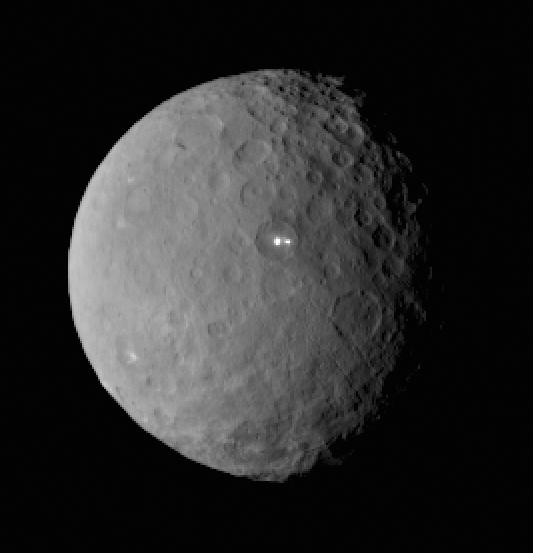
There’s still a debate about the unusually bright spots in some of Ceres craters that appear when the asteroid/dwarf planet turns into the sunlight. The team has speculated that they could be frozen pools of water ice, or patches of light-colored, salt-rich material.
The brightest spots are known collectively as Spot 5, and sit inside Occator Crater on Ceres, and hopefully new images of this area will be released soon. In a previous article on Universe Today, Dawn’s principal investigator, Chris Russell of the University of California at Los Angeles told us that the debate is continuing among the science team, but he wouldn’t harbor a guess as to which way the debate might end or which “side” was in the lead among the scientists.
“I originally was an advocate of ice, because of how bright the spots seemed to be,” Russell told writer Alan Boyle, but newer observations revealed the bright material’s albedo, or reflectivity factor, is about 50 percent – which is less than Russell originally thought. “This could be salt and is unlikely to be ice. I think the team opinion is now more in line with salt,” he said.
You can cast your vote as to what you think the bright spots are at this NASA page.
Topographic elevation map of Ceres showing some newly-named craters. Credit: NASA/JPL-Caltech/UCLA/MPS/DLR/IDA.
Ceres’ topography is revealed in full (but false) color in a new map created from elevation data gathered by NASA’s Dawn spacecraft, now nearly five months in orbit around the dwarf planet orbiting the Sun within the main asteroid belt.
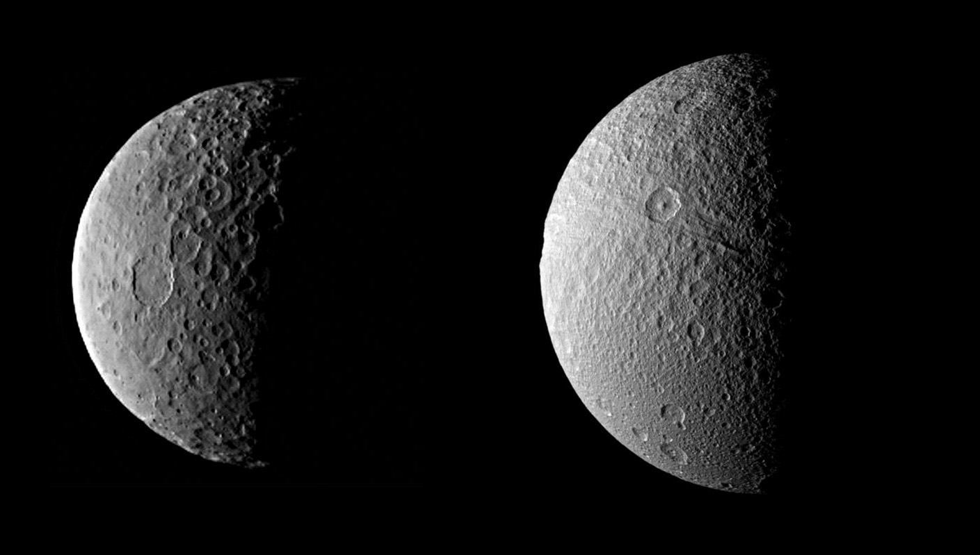
With craters 3.7 miles (6 km) deep and mountains rising about the same distance from its surface, Ceres bears a resemblance to some of Saturn’s frozen moons.
“The craters we find on Ceres, in terms of their depth and diameter, are very similar to what we see on Dione and Tethys, two icy satellites of Saturn that are about the same size and density as Ceres,” said Paul Schenk, Dawn science team member and a geologist at the Lunar and Planetary Institute (LPI) in Houston, TX. “The features are pretty consistent with an ice-rich crust.”
Check out a rotation video of Ceres’ topography below:
In addition to elevation mapping Ceres has also had some of its more prominent craters named. No longer just “bright spot crater” and “Spot 1,” these ancient impact scars now have official IAU monikers… from the Roman Occator to the Hawaiian Haulani to the Hopi Kerwan, craters on Ceres are named after agriculture-related gods and goddesses of mythologies from around the world.
Ceres’ famous “bright spot” crater is now named Occator, after the Roman god of harrowing. (NASA/JPL-Caltech/UCLA/MPS/DLR/IDA)
Dawn is currently moving closer toward Ceres into its third mapping orbit. By mid-August it will be 900 miles (1448 km) above Ceres’ surface and will proceed with acquiring data from this lower altitude, three times closer than it has been previously.
At 584 miles (940 km) in diameter Ceres is about 40 percent the size of Pluto.
NASA’s Dawn spacecraft is the first to successfully enter orbit around two different mission targets and the first to orbit a dwarf planet. Its first target was the asteroid Vesta, which it orbited from July 2011 to September 2012. Dawn arrived in orbit at Ceres on March 6, 2015 and there it will remain during its primary science phase and beyond; Ceres is now Dawn’s permanent home.
Ceres (left, Dawn image) compared to Tethys (right, Cassini image) at comparative scale sizes. (Credits: NASA/JPL-Caltech/UCLA/MPS/DLR/IDA and NASA/JPL-Caltech/SSI. Comparison by J. Major.)
The brightest spots on dwarf planet Ceres are seen in this image taken by NASA's Dawn spacecraft on June 6, 2015. The picture was taken from an altitude of 2,700 miles (4,400 kilometers). Credit: NASA/JPL-Caltech/UCLA/MPS/DLR/IDA
The crater that contains those puzzlingly bright spots on Ceres may harbor an equally puzzling haze. Or not. The hints of haze on the dwarf planet, seen in some of the images coming from NASA’s Dawn spacecraft, add another intriguing twist to Ceres’ mysteries.
The hubbub over haze arose this week during the Exploration Science Forum at NASA’s Ames Research Center in California. For months, Dawn’s scientists have been observing – and trying to make sense out of – unusually reflective spots within Ceres’ craters that show up when the asteroid turns into the sunlight. The team has speculated that they could be frozen pools of water ice, or patches of light-colored, salt-rich material.
The brightest spots are known collectively as Spot 5, and sit inside Occator Crater on Ceres. Dawn’s principal investigator, Chris Russell of the University of California at Los Angeles, told the forum that some type of haze could be seen inside the crater at certain times of Ceres’ day, according to reports from Nature and the Planetary Society. Nature quoted Russell as saying the bright spots “could be providing some atmosphere in this particular region of Ceres.”
Last year, scientists with the European Space Agency’s Herschel mission reported detecting signs of water vapor rising from Ceres’ surface, and it would be tempting to suggest that the water vapor is emanating from bright icy spots and creating the haze. That would strengthen Ceres’ status as the only asteroid with a significant atmosphere and a subsurface reservoir of water, and stoke speculation about life on Ceres.
However, Russell told Universe Today that it’s way too early to give in to temptation.
“I was speaking from less than a handful of images, and the interpretation of the images is disputed by some team members,” Russell said in an email. “I would like the debate to go on internally before we make a pronouncement one way or the other. I of course have my personal opinion, but I am not always right.”
Russell said the ice-vs.-salt debate is continuing. “I originally was an advocate of ice, because of how bright the spots seemed to be,” he said. However, the bright material’s albedo, or reflectivity factor, is about 50 percent – which is less than Russell originally thought. “This could be salt and is unlikely to be ice. I think the team opinion is now more in line with salt,” he said.
Either way, Russell doesn’t see any way for the spots to form without internal activity on Ceres. “Thus, the very existence of the spots tells us that there is some active process going on,” he told Universe Today.
Will we ever know if the haze is for real? Or what the spots are made of? As the Magic 8-Ball might say, “Ask again later.” The Dawn spacecraft recently recovered from a mechanical glitch and is gradually descending to a closer mapping orbit, around an altitude of 900 miles (1,500 kilometers). That will provide a much better look at Occator Crater and what lies within.
“Eventually I am expecting the spectral data will unambiguously tell us what has happened to the surface,” Russell said, “but it is a little too soon to be sure.”
Pluto with its enigmatic "crater" photographed on June 27. The apparent row of three depressions near the bottom of the globe are most likely artifacts from processing. Credit:
You’re probably as eager as I am for new images of Pluto and Ceres as both New Horizons and Dawn push ever closer to their respective little worlds. Recent photos, of which there are only a few, reveal some wild new features including what appears to a large crater on Pluto.
The latest photo of Pluto (lower left) and its largest moon Charon taken on June 29. A large possible crater-like feature is visible at lower right. Charon shows intriguing dark markings. Pluto’s diameter is 1,471 miles (700 miles smaller than Earth’s Moon); Charon is 750 miles across. Credit: NASA/Johns Hopkins University Applied Physics Laboratory/Southwest Research Institute
In the end, this apparent large impact might only be a contrast effect or worse, an artifact of over-processing, but there’s no denying its strong resemblance to foreshortened, shadow-filled craters seen on the Moon and other moons. It’s also encouraging that an earlier photo from June 27 shows the same feature. But the “crater” is just so … big! Its size seems disproportionate to the Pluto’s globe and recalls Saturn’s 246-mile-wide moon Mimas with its 81-mile-wide crater Herschel.
Pluto (right) and Charon, showing an unusual dark north polar cap or “anti-cap” in a photo taken by New Horizons’ long-range camera on June 19, 2015. The two were about 20 million miles away at the time. Credit: NASA/Johns Hopkins University Applied Physics Laboratory/Southwest Research Institute
Astronomers speculate the impact that gouged out Herschel came perilously close to shattering the moon to pieces. If it does turn out to be an crater, Pluto’s surface opposite the impact will likely show many fractures. Not to be outdone, the dwarf planet’s largest moon, Charon, is starting to show a personality of its own with a prominent dark north polar cap.
Since polar caps are normally bright, icy features, some have referred to this one as an “anti-polar cap”. Speaking of ice, the bright rim around Pluto in the photo above may be nitrogen frost condensing out of Pluto’s scant atmosphere as it slowly recedes from the Sun. Think how cold it must have to get for nitrogen to freeze out. How about -346° F (-210° C)! For new images of the Pluto system, be sure to check the New Horizons LORRI gallery page.
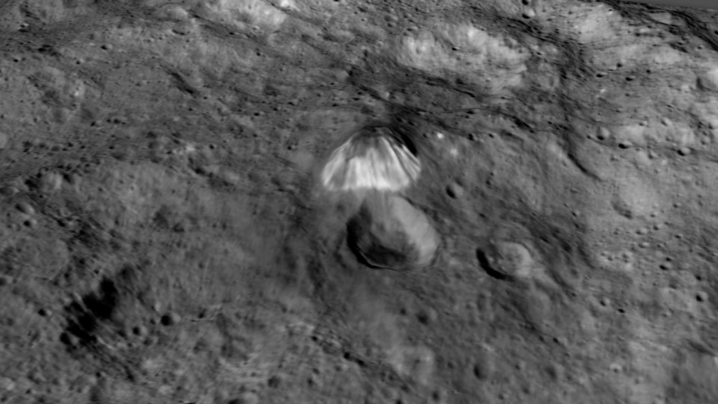
Dawn took this photo of an intriguing pyramidal mountain (top center) on Ceres on June 14 from an altitude of 2,700 miles. It rises 3 miles above a relatively smooth surface. Credit: NASA/JPL-Caltech/UCLA/MPS/DLR/IDA
Closer to home, new photos of Ceres show a peculiar, pyramid-shaped mountain towering 3 miles (5 km) high from a relatively smooth region between two large craters. Mountains poking from crater floors aren’t unusual. They’re tossed up after the crust later rebounds after a large impact. What makes this one unusual is the lack of an associated crater. Moreover, the mountain’s pale hue could indicate it’s younger than the surrounding landscape. As far as we can tell, it’s the only tall mountain on the face of the dwarf planet.
Another more overhead view of the mountain (right of center) taken by NASA’s Dawn probe on June 6. Credit: NASA/JPL-Caltech/UCLA/MPS/DLR/IDACropped version of the photo above. Notice the striations on the mountainside possibly from landslides. Credit: NASA/JPL-Caltech/UCLA/MPS/DLR/IDA
The Dawn team also photographed that cluster of white spots again, this time with a very shot exposure in to eke out more details. What do you think? If you’re as interested in asteroids as I am, Italian astrophysicist Gianluca Masi, a frequent photo contributor to Universe Today, will host a special live Asteroid Day event today starting at 6 p.m. CDT (23:00 UT). Masi will review near-Earth asteroids, explain discovery techniques and observe several in real time.
The Dawn team greatly underexposed Ceres in order to tease out more details from the white spot cluster in this image made on June 15 from 2,700 miles altitude. I’ve lightened the limb of Ceres to provide context. Credit: NASA/JPL-Caltech/UCLA/MPS/DLR/IDADawn photographed the large crater at left along with an interesting chain of craters and possible fault or collapse structures. Credit: NASA/Johns Hopkins University Applied Physics Laboratory/Southwest Research Institute
A rayed crater on Ceres with a great deal of fresh material (ice?) exposed by impact. Credit: NASA
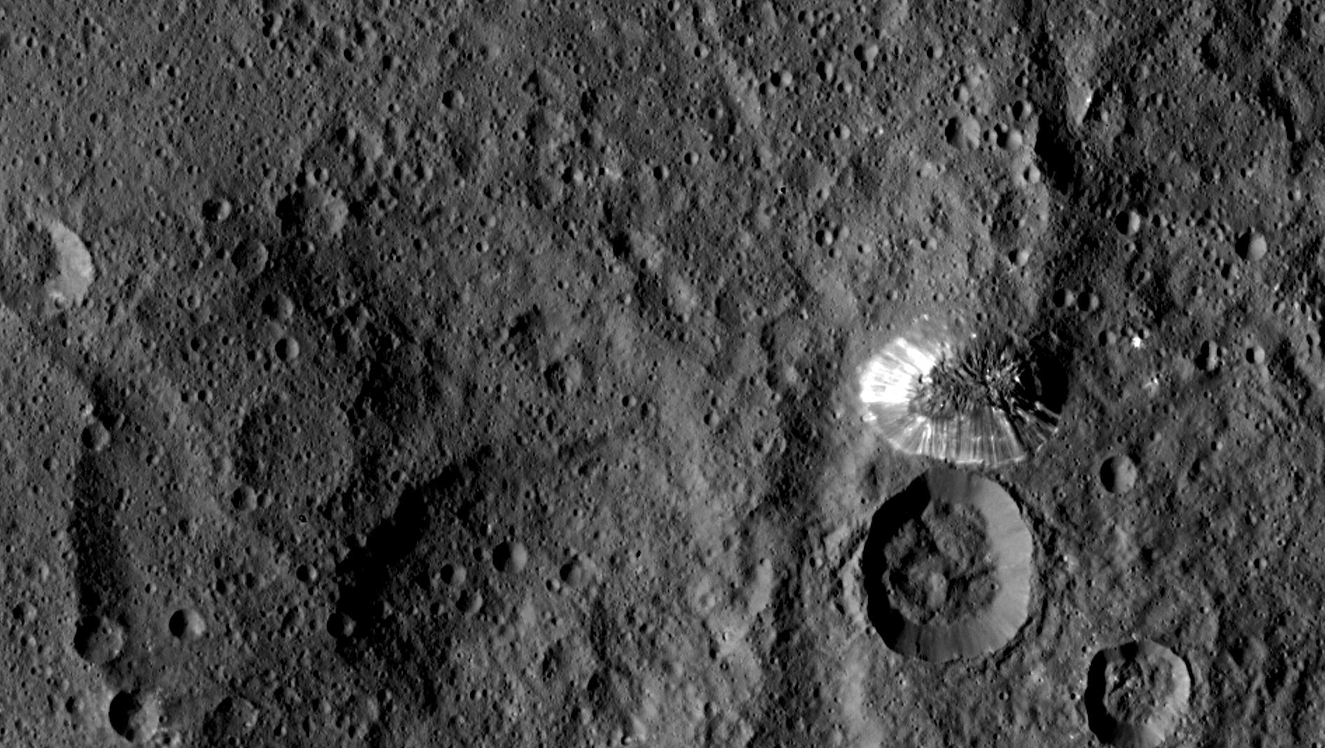
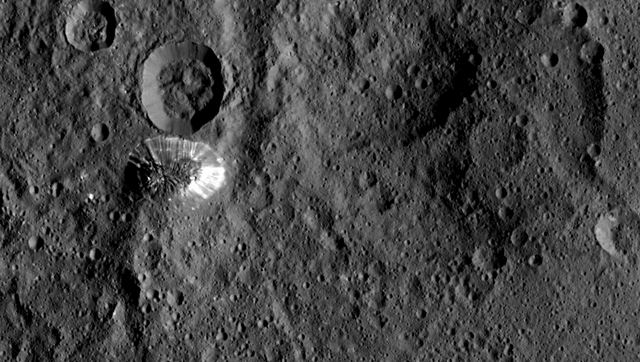
Those bright mystery spots aren’t the only ones on Ceres. Recent photos posted on JPL’s Photojournal sitefeature a spectacular rayed crater resembling the familiar lunar craters Kepler and Copernicus.
Unique view of the lunar crater Proclus showing an extension system of bright rays taken from Apollo 15. Credit: NASABright dots and patches of material are seen in this photo taken by Dawn on May 22, 2015 from 3,200 miles (5,100 km) away. Credit: NASA/JPL-Caltech/UCLA/MPS/DLR/IDATaken back on May 4 from 8,400 miles (13,600 km), this photo shows the rayed crater (bottom) and another bright spot above center. Credit: NASA/JPL-Caltech/UCLA/MPS/DLR/IDA
Lunar rays are bright because they contrast with their older surroundings which have been darkened by exposure to solar and cosmic radiation. Impacts expose fresh material from below the surface that settles into a spider web of rays around the newly excavated crater. Huge boulders lofted above the Moon’s surface during the impact slam back into the crust to create secondary craters also crowned with bright dust and rock.
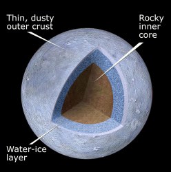
Based on Ceres’ density, it contains a large fraction of low density materials including clays, water ice, salts and organic compounds. This schematic gives a general idea of the dwarf planet’s makeup. Credit: NASA/ESA/STScI
Most models of Ceres depict a rocky crust, mantle of ice and a rocky inner core. This makes us wonder if the bright material unearthed might be ice. If so, it would gradually vaporize on the virtually air-free dwarf planet.
Dawn will spend through early 2016 at Ceres during its primary mission and then remain in orbit there perpetually. We should be able to cipher the composition of the white material during that time with the spacecraft’s Gamma Ray and Neutron Detector and Visible and Infrared Mapping Spectrometer, but a lengthy stay might allow us to see changes in the extent of any ice exposures as they gradually vaporize away.
Uncropped, untoned view of the rayed crater seen in the earlier image. Credit: NASA/JPL-Caltech/UCLA/MPS/DLR/IDA
One thing we know for certain about Ceres are its dimensions. Dawn observations have revised the size to be about 599 miles (963 km) across at the equator with a polar diameter of 554 miles (891 km). Like Earth and other planets, Ceres is a slightly flattened sphere wider at the equator than from pole to pole. The temperature there ranges from about -100°F (-73°C) during the day and dips to -225°F (-143°C) at night. That makes its daytime high about 28° warmer than coldest temperature ever recorded on Earth.
The brightest spots on dwarf planet Ceres are seen in this image taken by NASA's Dawn spacecraft on June 6, 2015. This is among the first snapshots from Dawn's second mapping orbit, which is 2,700 miles (4,400 kilometers) in altitude. The resolution is 1,400 feet (410 meters) per pixel. Credit: NASA/JPL-Caltech/UCLA/MPS/DLR/IDA
Don’t get me wrong. I love this new photo. Dawn snapped it from its second mapping orbit from 2,700 miles up on June 6. The number of craters and the detail visible in the parallel troughs snaking through the scene are breathtaking. That’s why I hate to niggle about the white spots.
While they appear larger and sharper than images taken in May from a greater distance, they’re too bright to show much new detail. I can’t help but wonder if mission scientists might adjust the exposure a bit the next time around.
Tighter crop on the 55-mile (90-km) crater that’s home to the cluster of white spots. I applied a small amount of sharpening and toned down the spots just a little. Credit: NASA/JPL-Caltech/UCLA/MPS/DLR/IDA
When photographing bright objects here on Earth, we expose “for the highlights” or the bright areas in photos to avoid overexposure and loss of detail.
What a satisfying view! This image, also taken on June 6, shows a large crater in Ceres’ southern hemisphere as well as cracks and radial fractures possibly associated with impacts. Credit: NASA/JPL-Caltech/UCLA/MPS/DLR/IDA
Naturally, when you try to capture details in something bright, your background will go dark. But that might be what’s needed here – a change in exposure to reveal more detail in the spots at the expense of the landscape. Doubtless NASA will release enlarged and detailed images of these enigmatic dots later this summer. Just call me impatient.
Scientists still don’t understand the nature of the spot cluster, but reflective ice or salt remain the strongest possibilities.
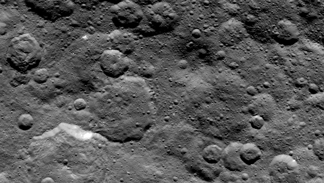
A lunar-like landscape in Ceres’ northern hemisphere photographed on June 6, 2015. Credit: NASA/JPL-Caltech/UCLA/MPS/DLR/IDA
“The bright spots in this configuration make Ceres unique from anything we’ve seen before in the solar system,” said Chris Russell, principal investigator for the Dawn mission. “The science team is working to understand their source. Reflection from ice is the leading candidate in my mind, but the team continues to consider alternate possibilities, such as salt.”
Images from Dawn’s visible and infrared mapping spectrometer (VIR) show a portion of Ceres’ cratered northern hemisphere, taken on May 16, 2015 from 4,500 miles (7,300 km) away. From top to bottom, the views include a black-and-white image, a true-color view and a temperature image. In the bottom infrared view, the lightest areas are hottest and darkest are the coolest. Credit: NASA/JPL-Caltech/UCLA/ASI/INAF
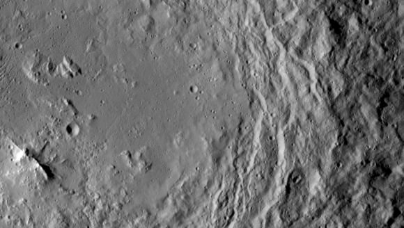
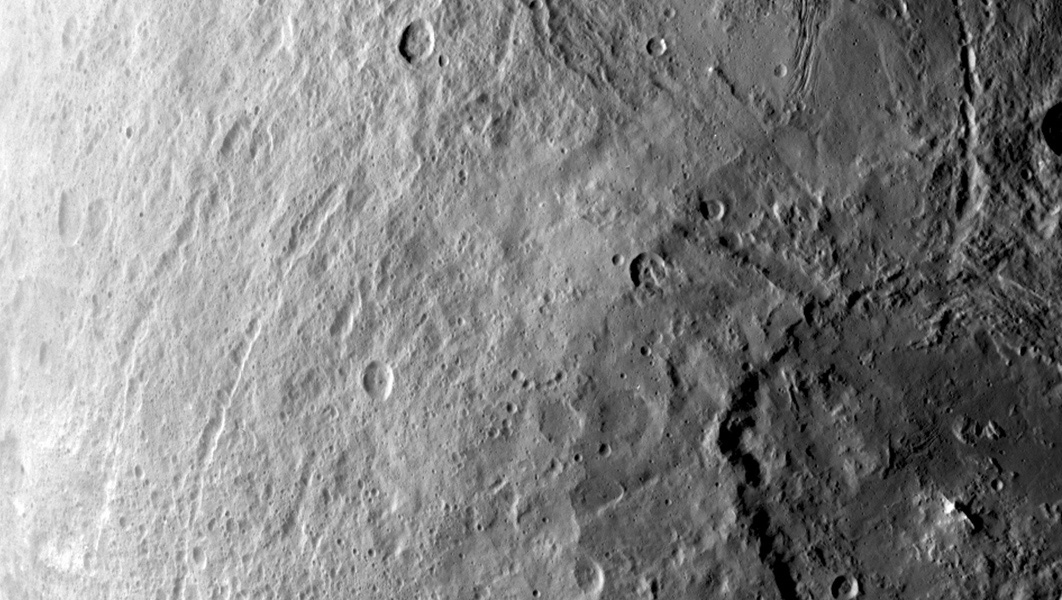
It’s interesting to compare and contrast Ceres with Dawn’s first target asteroid, Vesta. Craters of every size dominate both small worlds, but Ceres shows evidence of a more activity in the form of relaxed crater rims (possibly due to ice deformation), landslides and collapsed structures.
Dawn takes about three days to orbit at its current 2,700 mile altitude. It will continue to take photos and make science observations until dropping into a new lower altitude of 900 miles (1, 450 km) in early August.