
Ready for another Where In The Universe Challenge? Here’s #89! Take a look and see if you can name where in the Universe this image is from. Give yourself extra points if you can name the spacecraft responsible for the image. As usual, we’ll provide the image today, but won’t reveal the answer until tomorrow. This gives you a chance to mull over the image and provide your answer/guess in the comment section. Please, no links or extensive explanations of what you think this is — give everyone the chance to guess.
UPDATE: The answer is now posted below.
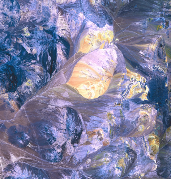
This is Earth, and specifically the Atacama Desert in northern Chile, where one of the world’s driest regions meets up with the foothills of the Andes Mountains. The colors come from salt pans and gorges choked with mineral-streaked sediments, giving way to white-capped volcanoes. This image was captured by the Advanced Spaceborne Thermal Emission and Reflection Radiometer (ASTER) instrument on NASA’s Terra satellite on October 28, 2001.
Source: NASA Earth Observatory
I’m guessing it’s Whistler, British Columbia, Canada… one of the sites of the Winter Olympics.
Earth, camera on-board the ISS.
Earth, some terrain-observing satellite, maybe Terra or Landsat.
Earth and yeah, possibly Terra.
Earth! Somewhere. Cold. Montain-ish.
Earth and probably LandSat
Strip mines or mountain ranges on earth from space.
It looks terrestrial. I have no idea where.
LC
Somewhere on Earth-however, it may be in China. The yellow color, it looks like loess deposits on the mountains that gives the Yellow (Hwang-Ho) river its’ name
I would guess near Nazsa in Chile. Looks like it may be some of the Nazca lines.
Landsat definitely… probably somewhere in Chile… one of the dumps for the mining site where they have all the waste fields
I’m guessing the Rocky mountain
Nazca lines, Earth.
You know I don’t think that’s Earth. Maybe its the colours, maybe the big feature in the centre or just the strange linear features near the top right.
I’ll stick my neck out somewhat – Looks like a micrograph of a mineral grain. Perhaps something returned by Stardust?
To me it appears to be magnified metallic crystals. Perhaps galena. (A lead compound once used for crystal radios.)
These always get me stumped – however…
Judging by the 4 straight and parallel lines in the top right of the image – and not only parallel but equidistant…
I’m going for Earth.
Image could be by any of a thousand satellites, but I’m going for ISS
Death Valley or possilby Nevada from the Terra satellite.
I don’t very often get into these, but my two cents here… How about a little closeup of Europa, uneven ice beds, cracks, reflections, and even the yellow area being a reflection of the Sun? For more trouble for me, maybe a very close Cassini fly-by?
I see roads, so it’s obviously Earth. The recent landslide near Machu Picchu, perhaps? ISS?
Now I’m second guessing even myself. A closer look reminded me of previous pics of wildfires from space, i.e. from ISS. Less smoke blowing away from fire = hotter areas. Note grey streaks going in similar direction. black and brown = burned out/smoldering areas.
It’s definitely a flat and arid region of earth. However not so arid that agriculture isn’t taking place (roads paralleling both sides of fence lines), along with minerals exploration (Equi-spaced tracks). My first guess would be an area in the Lake Eyre Basin, Australia. Maybe in or near the Diamantina River.
Alternatively, it could be in the Gobi Desert or the Sahara.
Io?
oh this one whas hard…
this is the andes, chile, Landsat 7 satellite…
love this!!!!
This one was great, very hard, I had nothing.