 Universe Today
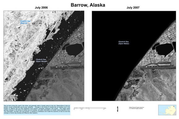
Last week the US government released more than a thousand intelligence images of Arctic ice that have been used to help scientists study the impact of climate change. The images were taken by spy satellites, as part of the Medea program, which lets scientists request spy pictures from environmentally sensitive locations around the world. After they were taken, the Bush Administration released the photographs to the scientists but deemed them "unsuitable for public release." Earlier this month, the National Academy of Sciences recommended the Obama Administration declassify the photos, which they did within a few hours of the recommendation.
Various blogs are saying these dramatic images are faked, but since they are available through the US Geological Survey , that hardly seems likely. Over 700 images show changes of sea ice in various recent years from six sites around the Arctic Ocean, with an additional 500 images of 22 sites in the United States.
Scientists request ice pictures to be taken by intelligence satellites because the resolution is much greater, in some cases, than other available satellite images. According to Reuters, the newly declassified Arctic images have a resolution of about 1 yard (1 meter), a vast improvement on previously available pictures of sea ice which have a resolution between 15 and 30 meters.
Sources: Reuters, USGS, TrueSlant