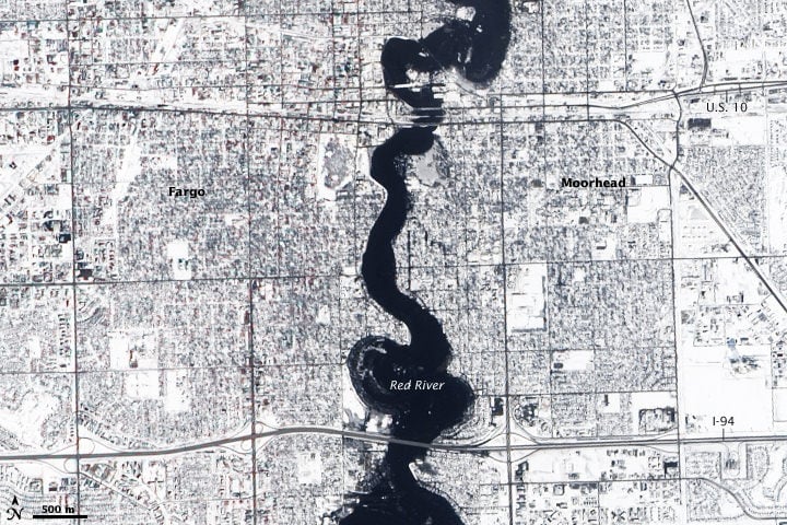
[/caption] The Red River reached a record high of 40.82 feet at Fargo, North Dakota on March 28, 2009, and flood stage for the river is 18 feet. This image, taken by the Advanced Land Imager on the Earth Observer-1 (EO-1) satellite on March 28, shows the swollen river, held in place by reinforced levees as it snakes through the region. Below you can compare images taken on March 28 and March 14 with NASA's Aqua satellite, to show how the flooding increased between the two dates. I have a personal interest in this natural disaster, as I grew up near Fargo and have family living there. Today, with the river easing slowly down to 38 feet, the Red River Valley was hit by a blizzard of between 10-20 inches of heavy, wet snow, according to
KVLY- KX4
meteorologist Mick Kjar (who happens to be my brother). So when this snow begins to melt, the river is expected to rise again.
[caption id="attachment_28367" align="aligncenter" width="580" caption="Red River Flooding, taken March 28 by MODIS on NASA's Aqua Satelite."]
[/caption] [caption id="attachment_28331" align="aligncenter" width="580" caption="Red River in early March. Credit: MODIS on NASA's Aqua satellite."]
[/caption] The snow that covered the region in both images was both the cause of the flood and the reason that the water stopped rising. The river flooded as melting snow from a deeper-than-average snowpack filled the basin, said the National Weather Service. While the return of colder weather has helped ease the flooding, the extra snow today will cause problems when it warms up again.
The Red River made an important drop today that took some pressure off Fargo-Moorhead's levee system. The Red is now down just below 38 feet. That's an important threshold because Fargo's permanent levee system is built to about 38 feet in most spots. Still, forecasters believe the river could rise again once all the snow melts, so they won't say the threat is over.
In these images, the scene is entirely white except for the river due to snowfall. In the top image, bridges on the two main roads, Interstate 94 near the bottom and Highway 10 near the top were both closed due to flooding.
Sources:
NASA Earth Observatory
,
KVLY-KX-4 News