[/caption]
Overnight, Alaska’s Redoubt volcano erupted with five large explosions. The National Weather Service has issued an Ashfall Advisory, with light ashfall already reported in some regions. Located about 100 miles southwest of Anchorage, Redoubt’s last eruption occurred in 1989-1990, causing widespread mudfalls or “lahars” and coated Anchorage and other nearby areas with ash. The ash affected air traffic as far south as Texas. Redoubt’s 3,108-meter (10,197-foot) peak has been belching steam for several weeks, with seismologists anticipating a possible eruption. Visible evidence of increased volcanic activity appeared at the alaska volcano summit from late January through February. Holes appeared in the ice, and streams of melt water cut across the surface of the Drift Glacier on Redoubt’s north flank.
The four explosions were recorded at 10:38 pm and 11:02 pm local time on March 22, and then at 2:14 am, 1:39 am and 4:37 am local time on March 23.
An Ashfall Advisory for the Susitna Valley means that all will likely be deposited there, and residents are advised to seal windows and doors, protect electronics and cover air intakes and open water supplies.

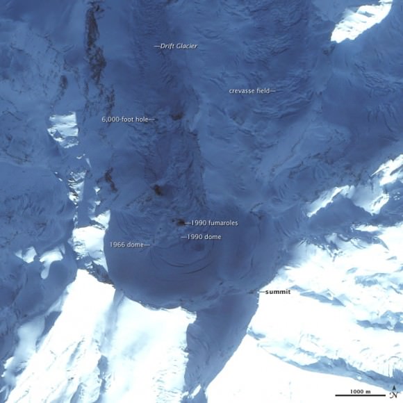
On January 24, 2008, the Alaska Volcano Observatory reported a pronounced increase in the number and intensity of tremors underneath Redoubt Volcano. Scientists at the observatory interpreted the seismic activity as a sign of unrest, and they raised the possibility of an eruption occurring in the near future. Shallow tremors This image, acquired by the Formosat-2 satellite on February 10, 2009, shows some signs of current activity, as well as evidence of past eruptions. Redoubt’s 3,108-meter (10,197-foot) summit is near image center, casting a deep shadow on the volcano’s crater. Buried under ice are two lava domes, formed during eruptions in 1966 and 1990. Dark holes in the northward-flowing Drift Glacier were formed where hot magma heated rocks underlying the ice. Crevasses on the steeply dropping glacier are also visible. The 6,000-foot hole is a pit in the snow caused by volcanic activity. On February 26, 2009, the Alaska Volcano Observatory observed a small lahar—an avalanche of volcanic matter—flowing from the 6,000-foot hole.
Source: Alaska Volcano Observatory, NASA’s Earth Observatory


Bobby Jindal was right: volcanic research is total waste of taxpayer money.
We should instead learn in science class that God’s hiccups sometimes spew lava and ash into the atmosphere.
(Lunatic.)
Dave-actually,research is required,tens’ of thousands were saved when Mt Pinotubo erupted in the Philippines. There are tens
of thousands in the path of deadly mudflows from Mt Rainier in the US not from a violent
eruption, just much heat collapsing the vast
glaciers and portions of the mountain top.
Countries like Indonesia, the island of Java has +100million people, and the entire island is volcanic, any eruption has the potential to kill 10s’ to 100s’ of thousands unless the people get out of the way. In the world, very many people live in areas close to vocanos because the soils created from the ash is excellent for food growing. There are areas not known to have volcanic activity may later have activity as the Earth is really a living
entity and if humans wants to survive, will have to get out of the way, so we have to know what are the signs, even though there is nothing humans can do to prevent an eruption.
This eruption looks like it might go into VEI=4 to 6. The volcano is just warming up, based on the limited data that I currently have on this eruption.
Next 24 to 72 hours (possible) are going to give us the clues on how big this eruption is going to be.
I am intrest in volcanoes and earthquakes.
Dave was being sarcastic.
What angle was that second picture taken at, my eyes can’t quite make sense of it?
Mark, the photo was taken from space (read copyright of image, Formosat) and in the lower right corner the indicator shows the north to be the top edge. Being late winter, bear in mind the sun will be low in the south sky for Alaska. Yes, it still looks a bit confusing to me too, but that is the best I can make of it for you. As for time of day, try mid to late afternoon with the strongest sun on the west (left) side of the ridges.
After reading this article, I feel that I need more information on the topic. Could you share some resources ?