25 Years Since Voyager’s ‘Pale Blue Dot’ Images

These six narrow-angle color images were made from the first ever "portrait" of the solar system taken by Voyager 1 on Valentine’s Day on Feb. 14, 1990, which was more than 4 billion miles from Earth and about 32 degrees above the ecliptic. Venus, Earth, Jupiter, and Saturn, Uranus, Neptune are seen in these blown-up images, from left to right and top to bottom. Credit: NASA/JPL-Caltech

A quarter of a century has passed since NASA’s Voyager 1 spacecraft snapped the iconic image of Earth known as the “Pale Blue Dot” that shows all of humanity as merely a tiny point of light.

The outward bound Voyager 1 space probe took the ‘pale blue dot’ image of Earth 25 years ago on Valentine’s Day, on Feb. 14, 1990 when it looked back from its unique perch beyond the orbit of Neptune to capture the first ever “portrait” of the solar system from its outer realms.

Voyager 1 was 4 billion miles from Earth, 40 astronomical units (AU) from the sun and about 32 degrees above the ecliptic at that moment.

The idea for the images came from the world famous astronomer Carl Sagan, who was a member of the Voyager imaging team at the time.

He head the idea of pointing the spacecraft back toward its home for a last look as a way to inspire humanity. And to do so before the imaging system was shut down permanently thereafter to repurpose the computer controlling it, save on energy consumption and extend the probes lifetime, because it was so far away from any celestial objects.

Sagan later published a well known and regarded book in 1994 titled “Pale Blue Dot,” that refers to the image of Earth in Voyagers series.
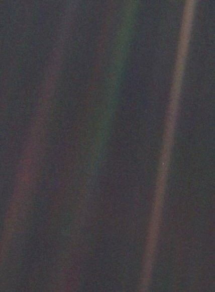
This narrow-angle color image of the Earth, dubbed "Pale Blue Dot," is a part of the first ever "portrait" of the solar system taken by Voyager 1 on Valentine’s Day on Feb. 14, 1990.  Credit: NASA/JPL-Caltech
This narrow-angle color image of the Earth, dubbed “Pale Blue Dot,” is a part of the first ever “portrait” of the solar system taken by Voyager 1 on Valentine’s Day on Feb. 14, 1990. Credit: NASA/JPL-Caltech

“Twenty-five years ago, Voyager 1 looked back toward Earth and saw a ‘pale blue dot,’ ” an image that continues to inspire wonderment about the spot we call home,” said Ed Stone, project scientist for the Voyager mission, based at the California Institute of Technology, Pasadena, in a statement.

Six of the Solar System’s nine known planets at the time were imaged, including Venus, Earth, Jupiter, and Saturn, Uranus, Neptune. The other three didn’t make it in. Mercury was too close to the sun, Mars had too little sunlight and little Pluto was too dim.

Voyager snapped a series of images with its wide angle and narrow angle cameras. Altogether 60 images from the wide angle camera were compiled into the first “solar system mosaic.”

Voyager 1 was launched in 1977 from Cape Canaveral Air Force Station in Florida as part of a twin probe series with Voyager 2. They successfully conducted up close flyby observations of the gas giant outer planets including Jupiter, Saturn, Uranus and Neptune in the 1970s and 1980s.

Both probes still operate today as part of the Voyager Interstellar Mission.

“After taking these images in 1990, we began our interstellar mission. We had no idea how long the spacecraft would last,” Stone said.

Hurtling along at a distance of 130 astronomical units from the sun, Voyager 1 is the farthest human-made object from Earth.

Solar System Portrait - 60 Frame Mosaic. The cameras of Voyager 1 on Feb. 14, 1990, pointed back toward the sun and took a series of pictures of the sun and the planets, making the first ever "portrait" of our solar system as seen from the outside.   Missing are Mercury, Mars and Pluto Credit:  NASA/JPL-Caltech
Solar System Portrait – 60 Frame Mosaic. The cameras of Voyager 1 on Feb. 14, 1990, pointed back toward the sun and took a series of pictures of the sun and the planets, making the first ever “portrait” of our solar system as seen from the outside. Missing are Mercury, Mars and Pluto. Credit: NASA/JPL-Caltech

Voyager 1 still operates today as the first human made instrument to reach interstellar space and continues to forge new frontiers outwards to the unexplored cosmos where no human or robotic emissary as gone before.

Here’s what Sagan wrote in his “Pale Blue Dot” book:

“That’s here. That’s home. That’s us. On it everyone you love, everyone you know, everyone you ever heard of, every human being who ever was, lived out their lives. … There is perhaps no better demonstration of the folly of human conceits than this distant image of our tiny world.”

Stay tuned here for Ken’s continuing Earth and planetary science and human spaceflight news.

Ken Kremer

Mariner 10: Best Venus Image and 1st Ever Planetary Gravity Assist – 40 Years Ago Today

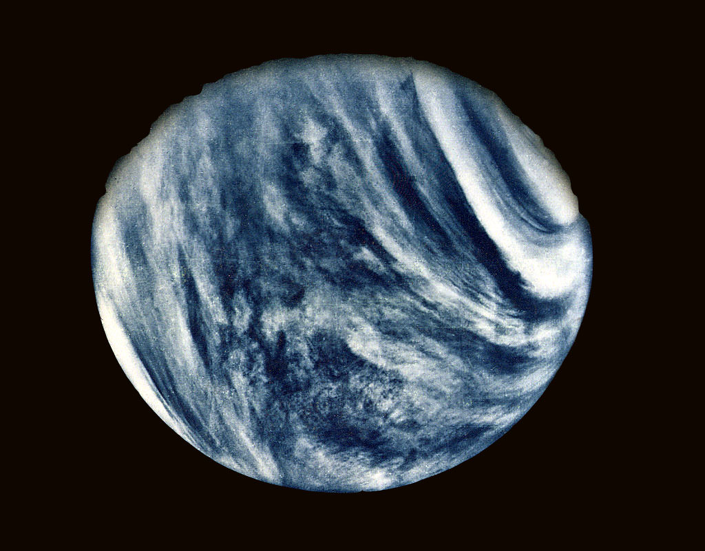
On Feb. 5, 1974, NASA's Mariner 10 mission took this first close-up photo of Venus during 1st gravity assist flyby. Credit: NASA

Exactly 40 Years ago today on Feb. 5, 1974, Mariner 10, accomplished a history making and groundbreaking feat when the NASA science probe became the first spacecraft ever to test out and execute the technique known as a planetary gravity assisted flyby used to alter its speed and trajectory – in order to reach another celestial body.

Mariner 10 flew by Venus 40 years ago to enable the probe to gain enough speed and alter its flight path to eventually become humanity’s first spacecraft to reach the planet Mercury, closest to our Sun.

Indeed it was the first spacecraft to visit two planets.

During the flyby precisely four decades ago, Mariner 10 snapped its 1st close up view of Venus – see above.

From that moment forward, gravity assisted slingshot maneuvers became an extremely important technique used numerous times by NASA to carry out planetary exploration missions that would not otherwise have been possible.

For example, NASA’s twin Voyager 1 and 2 probes launched barely three years later in 1977 used the gravity speed boost to conduct their own historic flyby expeditions to our Solar Systems outer planets.

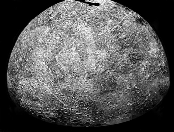
Mariner 10's Mercury.  This is a photomosaic of images collected by Mariner 10 as it flew past Mercury on 29 March 1974.  It shows the southern hemisphere.  The spacecraft took more than 7,000 images of Mercury, Venus, the Earth, and the moon during its mission.  Credit: NASA
Mariner 10’s Mercury.
This is a photomosaic of images collected by Mariner 10 as it flew past Mercury on 29 March 1974. It shows the southern hemisphere. The spacecraft took more than 7,000 images of Mercury, Venus, the Earth, and the moon during its mission. Credit: NASA

Without the flyby’s, the rocket launchers thrust by themselves did not provide sufficient interplanetary speed to reach their follow on targets.

NASA’s Juno Jupiter orbiter just flew back around Earth this past October 9, 2013 to gain the speed it requires to reach the Jovian system.

The Mariner 10 probe used an ultraviolet filter in its imaging system to bring out details in the Venusian clouds which are otherwise featureless to the human eye – as you’ll notice when viewing it through a telescope.

Venus surface is completely obscured by a thick layer of carbon dioxide clouds.

The hellish planet’s surface temperature is 460 degrees Celsius or 900 degrees Fahrenheit.

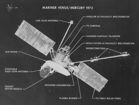
Diagram of Mariner 10 which flew by Venus and Mercury in 1974 and 1975. This photo identifies various parts of the spacecraft and the science instruments, which were used to study the atmospheric, surface, and physical characteristics of Venus and Mercury. This was the sixth in the series of Mariner spacecraft that explored the inner planets beginning in 1962. Credit: Jet Propulsion Laboratory

Following the completely successful Venus flyby, Mariner 10 eventually went on to conduct a trio of flyby’s of Mercury in 1974 and 1975.

It imaged nearly half of the planets moon-like surface, found surprising evidence of a magnetic field, discovered that a metallic core comprised nearly 80 percent of the planet’s mass, and measured temperatures ranging from 187°C on the dayside to minus 183°C on the nightside.

Mercury was not visited again for over three decades until NASA’s MESSENGER flew by and eventually orbited the planet – and where it remains active today.

Mariner 10 was launched on Nov. 3, 1973 from the Kennedy Space Center atop an Atlas-Centaur rocket.

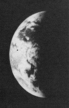
Mosaic of the Earth from Mariner 10 after launch. Credit: NASA
Shortly after blastoff if also took photos of the Earth and the Moon.

Ultimately it was the last of NASA’s venerable Mariner planetary missions hailing from the dawn of the Space Age.

Mariner 11 and 12 were descoped due to congressional budget cuts and eventually renamed as Voyager 1 and 2.

The Mariner 10 science team was led by Bruce Murray of the Jet Propulsion Laboratory (JPL), Pasadena, Calif.

Murray eventually became the Director of JPL. After he passed away in 2013, key science features on Martian mountain climbing destinations were named in his honor by the Opportunity and Curiosity Mars rover science teams.

Stay tuned here for Ken’s continuing LADEE, Chang’e-3, Orion, Orbital Sciences, SpaceX, commercial space, Mars rover and more planetary and human spaceflight news.

Ken Kremer

Mariner 10 trajectory and timeline to Venus and Mercury. Credit: NASA
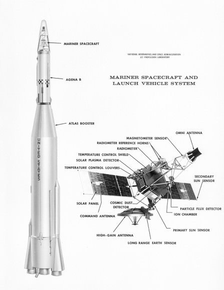
Diagram of the Mariner series of spacecraft and launch vehicle. Mariner spacecraft explored Mercury, Venus and Mars. Credit: Jet Propulsion Laboratory
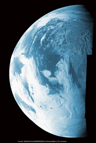
This false color composite shows more than half of Earth’s disk over the coast of Argentina and the South Atlantic Ocean as the Juno probe slingshotted by on Oct. 9, 2013 for a gravity assisted acceleration to Jupiter. The mosaic was assembled from raw images taken by the Junocam imager. Credit: NASA/JPL/SwRI/MSSS/Ken Kremer/Marco Di Lorenzo
Mosaic of Earth from Juno gravity assist Flyby in 2013 –
compare to Mariner 10 Earth mosaic above from 1973 to see advances in space technology
This false color composite shows more than half of Earth’s disk over the coast of Argentina and the South Atlantic Ocean as the Juno probe slingshotted by on Oct. 9, 2013 for a gravity assisted acceleration to Jupiter. The mosaic was assembled from raw images taken by the Junocam imager. Credit: NASA/JPL/SwRI/MSSS/Ken Kremer/Marco Di Lorenzo