Times are getting tougher in the battle to track space debris. A key asset in the fight to follow and monitor space junk is getting the axe on October 1st of this year. United States Air Force General and commander of Air Force Space Command William Shelton has ordered that the Air Force Space Surveillance System, informally known as Space Fence will be deactivated. The General also directed all related sites across the southern United States to prepare for closure.
This shutdown will be automatically triggered due to the U.S. Air Force electing not to renew its fifth year contract with Five Rivers Services, the Colorado Springs-based LLC that was awarded the contract for the day-to-day management of the Space Fence surveillance system in 2009.
To be sure, the Space Fence system was an aging one and is overdue for an upgrade and replacement.
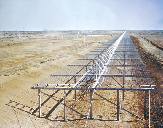
The Space Fence system was first brought on line in the early days of the Space Age in the 1961. Space Fence was originally known as the Naval Space Surveillance (NAVSPASUR) system until passing into the custody of the U.S. Air Force’s 20th Space Control Squadron in late 2004. Space Fence is a series of multi-static VHF receiving and transmitting sites strung out across the continental United States at latitude 33° north ranging from California to Georgia.
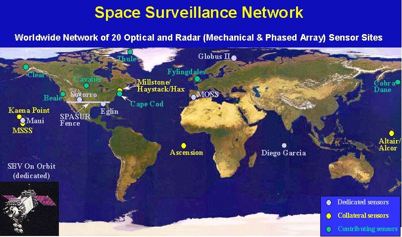
Space Fence is part of the greater Space Surveillance Network, and comprises about 40% of the overall observations of space debris and hardware in orbit carried out by the U.S. Air Force. Space Fence is also a unique asset in the battle to track space junk and dangerous debris, as it gives users an “uncued” tracking ability. This means that it’s constantly “on” and tracking objects that pass overhead without being specifically assigned to do so.
Space Fence also has the unique capability to track objects down to 10 centimeters in size out to a distance of 30,000 kilometres. For contrast, the average CubeSat is 10 centimetres on a side, and the tracking capability is out to about 67% of the distance to geosynchronous orbit.
Exact capabilities of the Space Fence have always been classified, but the master transmitter based at Lake Kickapoo, Texas is believed to be the most powerful continuous wave facility in the world, projecting at 768 kilowatts on a frequency of 216.97927 MHz. The original design plans may have called for a setup twice as powerful.
A replacement for Space Fence that will utilize a new and upgraded S-Band radar system is in the works, but ironically, that too is being held up pending review due to the sequestration. Right now, the Department of Defense is preparing for various scenarios that may see its budget slashed by 150 to 500 billion dollars over the next 10 years.
The U.S. Air Force has already spent $500 million to design the next generation Space Fence, and awarded contracts to Raytheon, Northrop Grumman and Lockheed Martin in 2009 for its eventual construction.
The eventual $3 billion dollar construction contract is on hold, like so many DoD programs, pending assessment by the Strategic Choices and Management Review, ordered by Secretary of Defense Chuck Hagel earlier this year.
“The AFSSS is much less capable than the space fence radar planned for Kwajalein Island in the Republic of the Marshall Islands,” stated General Shelton in a recent U.S. Air Force press release. “In fact, it’s apples and oranges in trying to compare the two systems.”
One thing’s for certain. There will be a definite capability gap when it comes to tracking space debris starting on October 1st until the next generation Space Fence comes online, which may be years in the future.
In the near term, Air Force Space Command officials have stated that a “solid space situational awareness” will be maintained by utilizing the space surveillance radar at Eglin Air Force Base in the Florida panhandle and the Perimeter Acquisition Radar Characterization System at Cavalier Air Force Station in North Dakota.
We’ve written about the mounting hazards posed by space debris before. Just earlier this year, two satellites were partially damaged due to space debris. Space junk poses a grave risk to the residents of the International Space Station, which must perform periodic Debris Avoidance Maneuvers (DAMs) to avoid collisions. Astronauts have spotted damage on solar arrays and handrails on the ISS due to micro-meteoroids and space junk. And on more than one occasion, the ISS crew has sat out a debris conjunction that was too close to call in their Soyuz spacecraft, ready to evacuate if necessary.
In 2009, a collision between Iridium 33 and the defunct Cosmos 2251 satellite spread debris across low Earth orbit. In 2007, a Chinese anti-satellite missile test also showered low Earth orbit with more of the same. Ironically, Space Fence was crucial in characterizing both events.
Satellites, such as NanoSail-D2, have demonstrated the capability to use solar sails to hasten reentry at the end of a satellites’ useful life, but we’re a long ways from seeing this capability standard on every satellite.
Amateurs will be affected by the closure of Space Fence as well. Space Weather Radio relies on ham radio operators, who listen for the “pings” generated by the Space Fence radar off of meteors, satellites and spacecraft.
“When combined with the new Joint Space Operations Center’s high-performance computing environment, the new fence will truly represent a quantum leap forward in space situational awareness for the nation,” General Shelton said.
But for now, it’s a brave and uncertain world, as Congress searches for the funds to bring this new resource online. Perhaps the old system will be rescued at the 11th hour, or perhaps the hazards of space junk will expedite the implementation of the new system. Should we pass the hat around to “Save Space Fence?”