What Created This Huge Crater In Siberia?

An 80-meter-wide crater recently discovered in northern Siberia (Video screenshot)

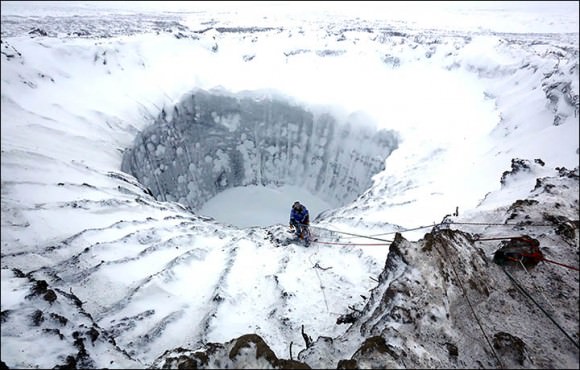
What is it with Russia and explosive events of cosmic origins? The 1908 Tunguska Explosion, the Chelyabinsk bolide of February 2013, and now this: an enormous 80-meter 60-meter wide crater discovered in the Yamal peninsula in northern Siberia!

To be fair, this crater is not currently thought to be from a meteorite impact but rather an eruption from below, possibly the result of a rapid release of gas trapped in what was once frozen permafrost. The Yamal region is rich in oil and natural gas, and the crater is located 30 km away from its largest gas field. Still, a team of researchers are en route to investigate the mysterious hole further.

Watch a video captured by engineer Konstantin Nikolaev during a helicopter flyover below:

In the video the Yamal crater/hole has what appear to be streams of dry material falling into it. Its depth has not yet been determined. (Update: latest measurements estimate the depth of the hole to be 50-70 meters. Source.)

Bill Chappell writes on NPR’s “The Two-Way”:

“The list of possible natural explanations for the giant hole includes a meteorite strike and a gas explosion, or possibly an eruption of underground ice.”

Dark material around the inner edge of the hole seems to suggest high temperatures during its formation. But rather than the remains of a violent impact by a space rock — or the crash-landing of a UFO, as some have already speculated — this crater may be a particularly explosive result of global warming.

According to The Siberian Times:

“Anna Kurchatova from Sub-Arctic Scientific Research Centre thinks the crater was formed by a water, salt and gas mixture igniting an underground explosion, the result of global warming. She postulates that gas accumulated in ice mixed with sand beneath the surface, and that this was mixed with salt – some 10,000 years ago this area was a sea.”

The crater is thought to have formed sometime in 2012.

Read more at The Siberian Times and NPR.

UPDATE July 17: A new video (in Russian) of the hole from the research team has come out, and apparently it’s been made clear that it’s not the result of a meteorite. Exactly what process did produce it is still unknown, but rising temperatures are still thought to be a factor. Watch below (via Sploid).

(If any Russian-speaking UT readers would like to translate what’s being said, feel free to share in the comments below.)

Also check out the latest photos from the research expedition at The Siberian Times here.

UPDATE Nov. 13: Once the water in these holes froze solid scientists were able to enter and explore the bottoms. According to an article published on The Guardian, “eighty percent of the crater appears to be made up of ice and there are no traces of a meteorite strike.”

Researchers descend into an ice-covered Yamal Crater in Siberia. Credit: Vladimir Pushkarev/Russian Centre of Arctic Exploration (via Siberian Times) 
Researchers descend into an ice-covered Yamal Crater in Siberia. Credit: Vladimir Pushkarev/Russian Centre of Arctic Exploration (via Siberian Times)

“As of now we don’t see anything dangerous in the sudden appearance of such holes, but we’ve got to study them properly to make absolutely sure we understand the nature of their appearance and don’t need to be afraid about them.”

– Vladimir Pushkarev, Director, Russian Center of Arctic Exploration

See more photos from inside the crater from the Russian Center of Arctic Exploration on The Siberian Times here.

Evidence Of Giant, Growing Louisiana Sinkhole Showed Up In Radar Before Collapse: NASA

A 25-acre sinkhole near Bayou Corne, Louisiana that formed in Aug. 2012. In 2014, a new analysis of NASA radar data found that the sinkhole was evident in that information before its collapse. Credit: On Wings of Care, New Orleans, La.

A Louisiana sinkhole the size of 19 American football fields shifted sideways in radar measurements before its collapse and resulting evacuations in 2012, a study reveals.

The implication is that if certain types of radar measurements are collected regularly from above, it is possible to see some sinkholes before they collapse. The researchers added, however, that their discovery was “serendipitous” and there are no plans to immediately use a NASA robotic Gulfstream plane used for the study to fly over spots that could be vulnerable to sinkholes.

Data showed the ground near Bayou Corne moving horizontally up to 10.2 inches (26 centimeters) toward where the sinkhole appeared suddenly in August 2012. The hole started out at about 2 acres of size (1 hectare) — an area smaller than the initial ground movements — and now measures about 25 acres (10 hectares).

The research was published in the journal Geology in February, and was first made available online in December. NASA highlighted the information in a press release published in early March.

“While horizontal surface deformations had not previously been considered a signature of sinkholes, the new study shows they can precede sinkhole formation well in advance,” stated Cathleen Jones, leader of the research and a part of NASA’s Jet Propulsion Laboratory in California.

Regions and rock types of the United States that could be vulnerable to sinkholes. Credit: U.S. Geological Survey

“This kind of movement may be more common than previously thought, particularly in areas with loose soil near the surface.”

Jones and her NASA JPL colleague, Blom, found the information in NASA’s interferometric synthetic aperture radar (inSAR), which flew over the region in June 2011 and July 2012 on the agency’s Uninhabitated Aerial Vehicle Synthetic Aperture Radar. The radar can see shifts in the Earth’s surface.

The sinkhole — which is full of water and ground-up solids and is still getting bigger — collapsed after several small earthquakes and after the community became aware of “bubbling natural gas” in the area, NASA stated.

A sinkhole threatens the nearby community of Bayou Corne, Louisiana in this image released on NASA's website in March 2014. Credit: NASA/JPL-Caltech
A sinkhole threatens the nearby community of Bayou Corne, Louisiana in this image released on NASA’s website in March 2014. Credit: NASA/JPL-Caltech

“It was caused by the collapse of a sidewall of an underground storage cavity connected to a nearby well operated by Texas Brine Company and owned by Occidental Petroleum,” the agency added.

“On-site investigation revealed the storage cavity, located more than 3,000 feet (914 meters) underground, had been mined closer to the edge of the subterranean Napoleonville salt dome than thought.” (A salt dome is a location in sedimentary rocks where salt is pushed up beneath the surface.)

Measurements of the area were taken as recently as October 2013, as the growing sinkhole is threatening the nearby community as well as a highway in the region.

Source: NASA