Dramatic 3 D Imagery Showcases Vesta’s Pockmarked, Mountainous and Groovy Terrain

3 D Anaglyph of Craters at Rheasilvia - the South Polar Region of Vesta. This 3-D image shows the topography, craters and grooves of Vesta’s south polar region obtained by the framing camera instrument aboard NASA’s Dawn spacecraft on Aug. 23 and 28, 2011. The image has a resolution of about 260 meters per pixel.

[/caption]

Try not to plummet off a steep crater cliff or be buried under a landslide while gazing at the irresistibly alluring curves of beautiful Rheasilvia – the mythical mother of Romulus and Remus – whose found a new home at the South Pole of the giant Asteroid Vesta.

3 D is undoubtedly the best way to maximize your pleasure. So whip out your cool red-cyan anaglyph glasses to enhance your viewing experience of Rheasilvia, the Snowman and more – and maximize your enjoyment of this new 3 D collection showcasing the heavily cratered, pockmarked, mountainous and groovy terrain replete at Vesta.

3D Details of Wave-Like Terrain in the South Pole of Vesta
This image was obtained by NASA’s Dawn spacecraft from an orbit of about 1,700 miles (2,700 kilometers) above the surface of the giant asteroid Vesta. Topography in the area surrounding Vesta's south pole area shows impact craters, ridges and grooves. These images in 3D provide scientists with a realistic impression of the solid surface of the celestial body.
Credit: NASA/JPL-Caltech/UCLA/MPS/DLR/IDA
Can you find the location of the 3 D image above in the 2 D South Pole image below?

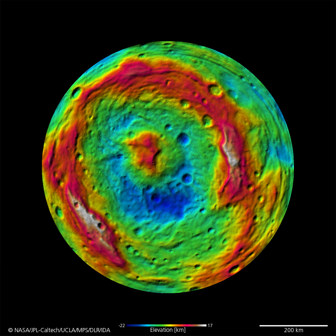
Scientists and mortals have been fascinated by the enormous impact crater Rheasilvia and central mountain unveiled in detail by NASA’s Dawn Asteroid Orbiter recently arrived at Vesta, the 2nd most massive object in the main asteroid belt. Ceres is the largest object and will be Dawn’s next orbital target in 2015 after departing Vesta in 2012.

3D - A Big Mountain at Asteroid Vesta’s South Pole
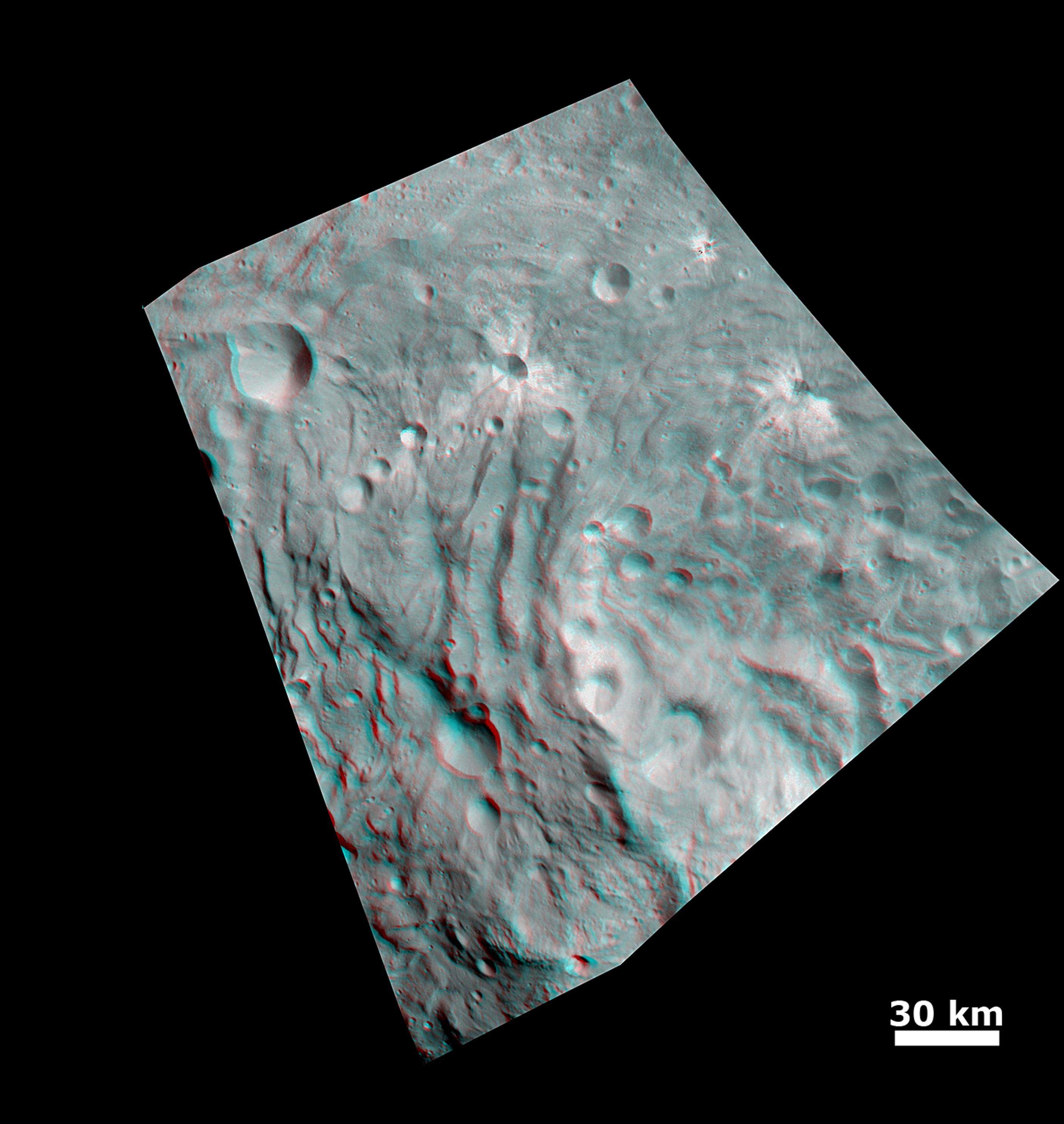
Scientists were fascinated by this enormous mound inside a big circular depression at the south pole- dubbed Rheasilvia. This stereo image was recorded from an altitude of about 1,700 miles (2,700 kilometers) above the surface and shows the structure of the mountain, displayed in the right half of this 3D image. The base of the mountain has a diameter of about 125 miles (200 kilometers), and its altitude above the surroundings is about 9 miles (15 kilometers). The vicinity of the peak of the mountain shows landslides that occurred when material from the flanks of the mountain were slipping down. Also visible are tectonic structures from tension in Vesta's crust. Credit: NASA/JPL-Caltech/UCLA/MPS/DLR/IDA

Vesta is the smallest terrestrial planet in our Solar System”, said Chris Russell in an interview with Universe Today. “We do not have a good analog to Vesta anywhere else in the Solar System.”

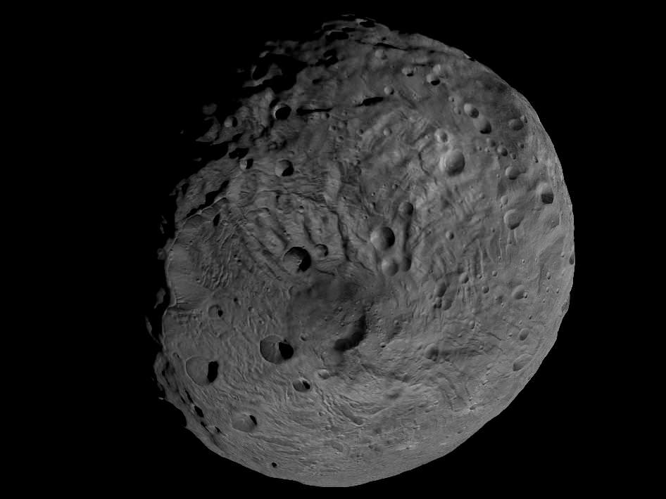
And the best is yet to come. In a few days, Dawn begins snapping images from a much lower altitude at the HAMO mapping orbit of ca. 685 km vs the initial survey orbit of ca, 2700 km. where most of these images were taken.

Can you find the location of the 3 D South Pole images above in the 2 D South Pole image below?

Topography of Densely Cratered Deformed Terrain
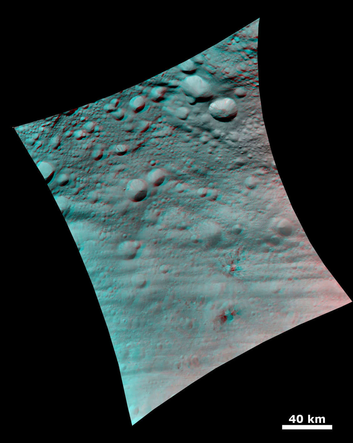
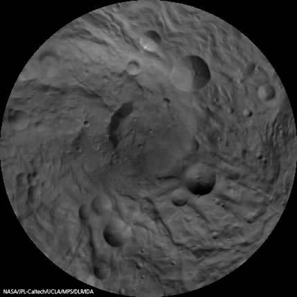
This 3 D anaglyph image shows the topography of Vesta's densely cratered terrain obtained by the framing camera instrument aboard NASA's Dawn spacecraft on August 6, 2011. Credit: NASA/JPL-Caltech/UCLA/MPS/DLR/IDA
Anaglyph of the ‘Snowman' Crater. This anaglyph image shows the topography of Vesta's three craters, informally named the "Snowman," obtained by the framing camera instrument aboard Dawn on August 6, 2011. The camera has a resolution of about 260 meters per pixel. Credit: NASA/JPL-Caltech/UCLA/MPS/DLR/IDA
Vesta's Ancient, Cratered Surface in 3D
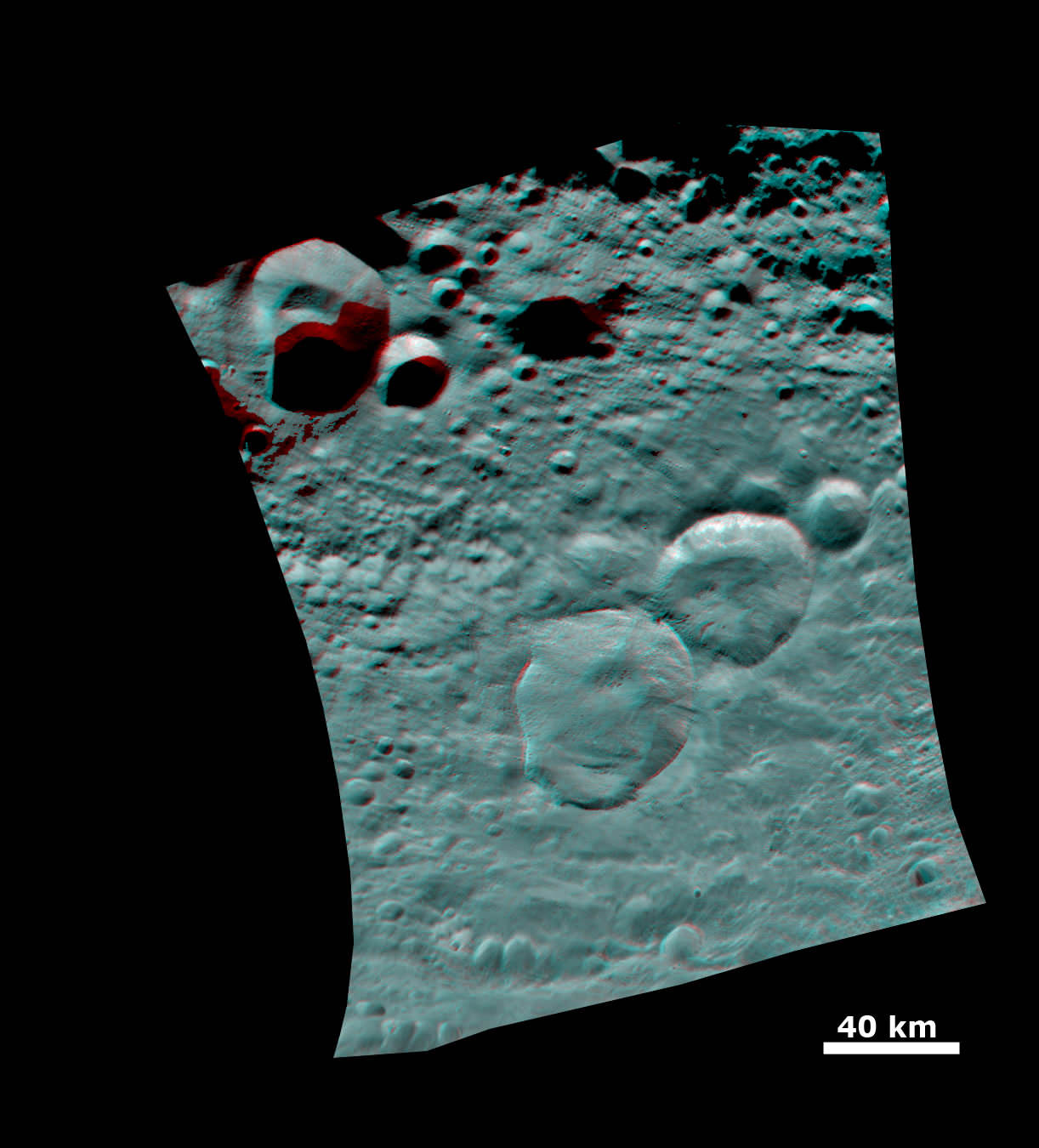
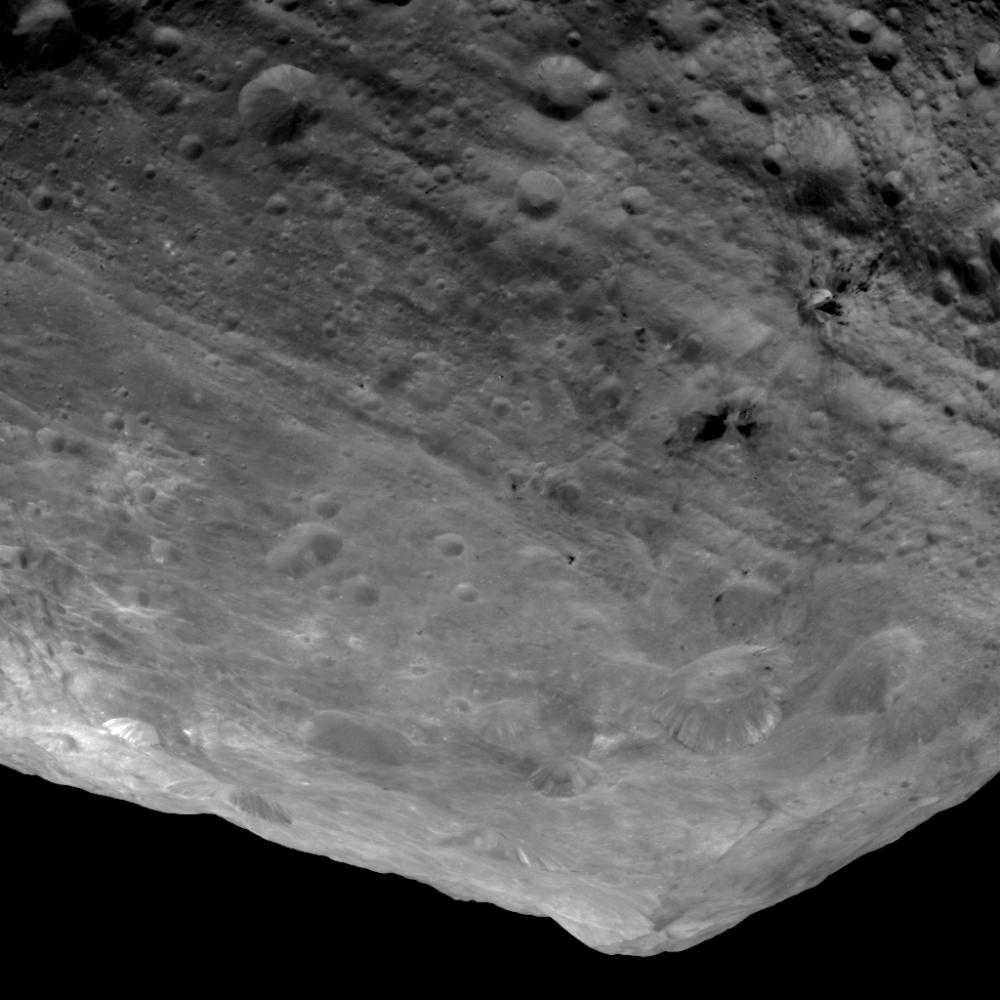
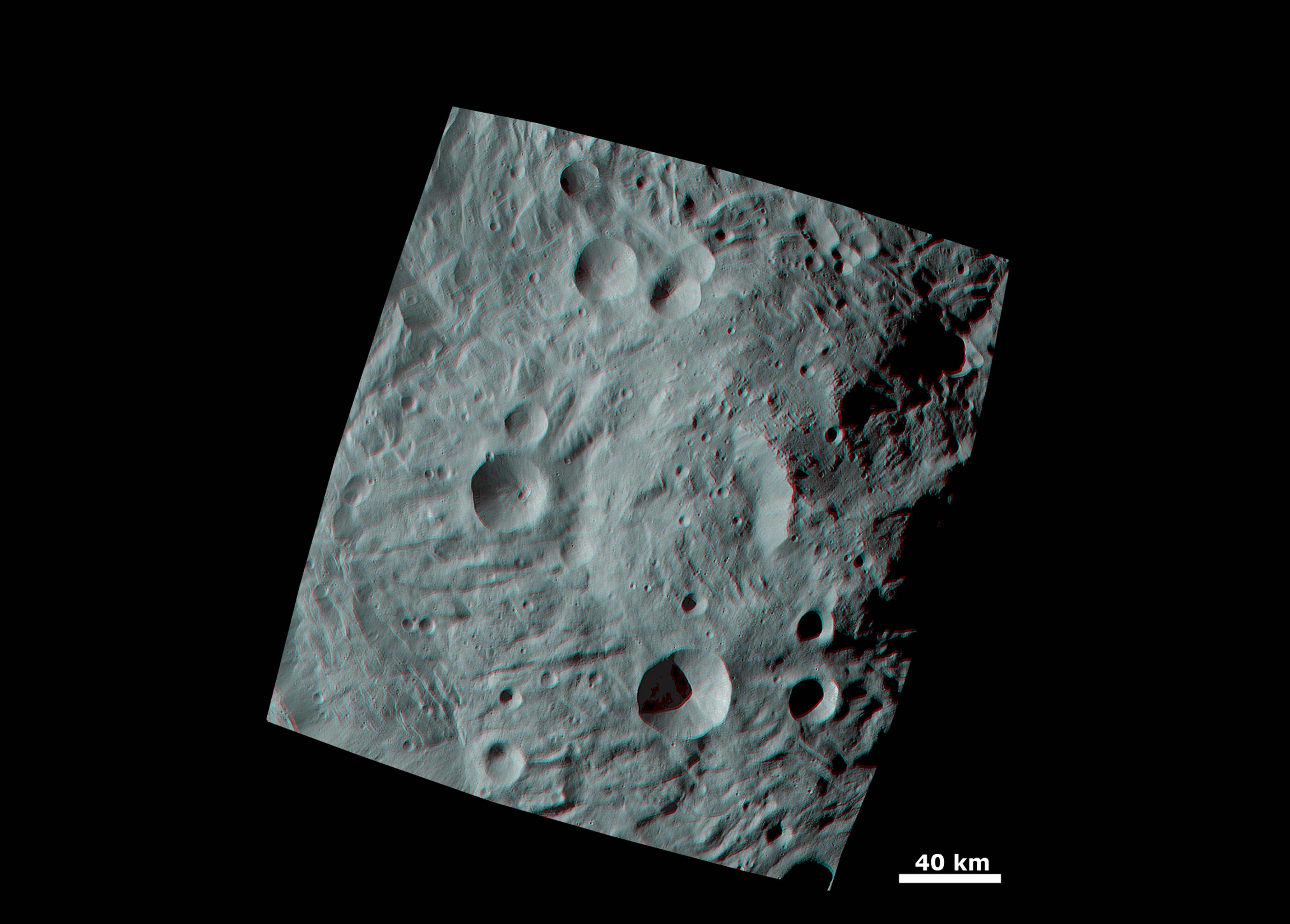
This image of the giant asteroid Vesta obtained by NASA's Dawn spacecraft shows the surface of the asteroid from an orbit of about 1,700 miles (2,700 kilometers) above the surface. Numerous impact craters illustrate the asteroid's violent youth. By counting craters on distinct geological surfaces scientists can deduce relative ages of the asteroid's surface. This 3D view provides scientists the opportunity to learn more about the morphology of craters on asteroids and physical properties of the material at Vesta's surface.. Image resolution is about 260 meters per pixel. Credit: NASA/JPL-Caltech/UCLA/MPS/DLR/IDA
Viewing the South Pole of Vesta and Rheasilvia Impact Basin
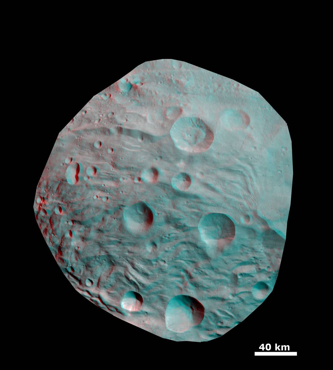
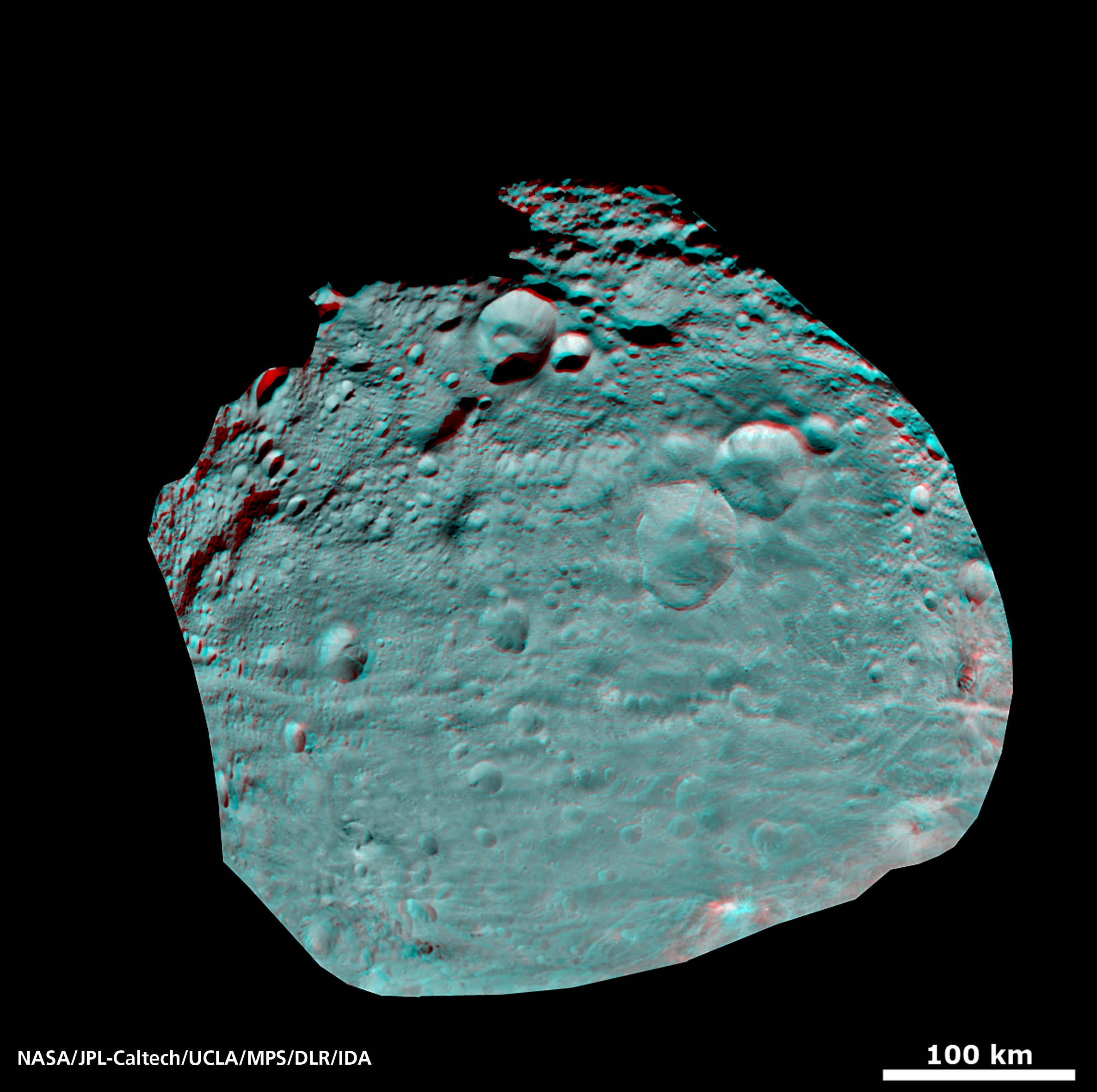
This image obtained by Dawns framing camera shows the south pole of the giant asteroid Vesta. Scientists are discussing whether the Rheasilvia circular structure that covers most of this image originated by a collision with another asteroid, or by internal processes early in the asteroid's history. Images in higher resolution from Dawn's next lowered orbit might help answer that question. The image was recorded from a distance of about 1,700 miles (2,700 kilometers). The image resolution is about 260 meters per pixel. Credit: NASA/JPL-Caltech/UCLA/MPS/DLR/IDA
Rhea Silvia, torso from the amphitheatre at Cartagena in Spain that was rediscovered in 1988. Rhea Silvia was the mother of Romulus and Remus, the mythical founders of Rome. Source: Wikipedia

Read Ken’s continuing features about Dawn and Vesta

Rheasilvia – Super Mysterious South Pole Basin at Vesta
Space Spectacular — Rotation Movies of Vesta
3 D Alien Snowman Graces Vesta
NASA Unveils Thrilling First Full Frame Images of Vesta from Dawn
Dawn Spirals Down Closer to Vesta’s South Pole Impact Basin
First Ever Vesta Vistas from Orbit – in 2D and 3D
Dawn Exceeds Wildest Expectations as First Ever Spacecraft to Orbit a Protoplanet – Vesta
Dawn Closing in on Asteroid Vesta as Views Exceed Hubble
Dawn Begins Approach to Asteroid Vesta and Snaps First Images
Revolutionary Dawn Closing in on Asteroid Vesta with Opened Eyes

Rheasilvia – Super Mysterious South Pole Basin at Vesta is Named after Romulus and Remus Roman Mother

A False-Color Topography of Vesta's South Pole. This false-color map of the giant asteroid Vesta was created from stereo images obtained by the framing camera aboard NASA’s Dawn spacecraft. The image shows the elevation of surface structures with a horizontal resolution of about 750 meters per pixel. The terrain model of Vesta's southern hemisphere shows a big circular structure with a diameter of about 300 miles (500 kilometers), its rim rising above the interior of the structure for more than 9 miles (15 kilometers.) Image credit: NASA/JPL-Caltech/UCLA/MPS/DLR/IDA

Video caption: Rheasilvia Impact Basin and Vesta shape model. This false-color shape model video of the giant asteroid Vesta was created from images taken by the framing camera aboard NASA’s Dawn spacecraft. Rheasilvia – South Pole Impact Basin – shown at bottom (left) and head on (at right). Credit: NASA/JPL-Caltech/UCLA/MPS/DLR/IDA

‘Rheasilvia’ – that’s the brand new name given to the humongous and ever more mysterious South Pole basin feature being scrutinized in detail by Dawn, according to the missions top scientists in a Universe Today exclusive. Dawn is NASA’s newly arrived science orbiter unveiling the giant asteroid Vesta – a marvelously intriguing body unlike any other in our Solar System.

What is Rheasilvia? An impact basin? A crater remnant? Tectonic action? A leftover from internal processes? Or something completely different? That’s the hotly debated central question consuming loads of attention and sparking significant speculation amongst Dawn’s happily puzzled international science team. There is nothing closely analogous to Vesta and Rhea Silvia – and thats a planetary scientists dream come true.

“Rheasilvia – One thing that we all agree on is that the large crater should be named ‘Rheasilvia’ after the mother of Romulus and Remus, the mythical mother of the Vestals,” said Prof. Chris Russell, Dawns lead scientist, in an exclusive interview with Universe Today. Russell, from UCLA, is the scientific Principal Investigator for Dawn.

“Since we have never seen any crater just like this one it is difficult for us to decide exactly what did happen,” Russell told me. “The name ‘Rheasilvia’ has been approved by the IAU and the science team is using it.”

Craters on Vesta are being named after the Vestal Virgins—the priestesses of the Roman goddess Vesta. Other features will be named for festivals and towns of that era. Romulus and Remus were the mythical founders of Rome.
[/caption]

‘Rheasilvia’ has the science team in a quandary, rather puzzled and reevaluating and debating long held theories as they collect reams of new data from Dawn’s three science instruments – provided by the US, Germany and Italy. That’s the scientific method in progress and it will take time to reach a consensus.

Prior to Dawn’s orbital insertion in July 2011, the best views of Vesta were captured by the Hubble Space Telescope and clearly showed it wasn’t round. Scientists interpreted the data as showing that Vesta’s southern hemisphere lacked a South Pole! And, that it had been blasted away eons ago by a gargantuan cosmic collision that excavated huge amounts of material that nearly utterly destroyed the asteroid.

The ancient collision left behind a colossal 300 mile (500 km) diameter and circular gaping hole in the southern hemisphere – nearly as wide as the entire asteroid (530 km) and leaving behind an as yet unexplained and enormous central mountain peak, measuring some 9 miles (15 km) high and over 125 miles (200 km) in diameter. The mountain has one of the highest elevations in the entire solar system.

“We are trying to understand the high scarps that we see and the scarps that should be there and aren’t,” Russell explained. “We are trying to understand the landslides we think we see and why the land slid. We see grooves in the floor of the basin and want to interpret them.

“And the hill in the center of the crater remains as mysterious today as when we first arrived.”

Viewing the South Pole of Vesta and Rheasilvia Impact Basin
This image obtained by Dawns framing camera and shows the south pole of the giant asteroid Vesta. Scientists are discussing whether the Rheasilvia circular structure that covers most of this image originated by a collision with another asteroid, or by internal processes early in the asteroid's history. Images in higher resolution from Dawn's lowered orbit might help answer that question. The image was recorded from a distance of about 1,700 miles (2,700 kilometers). The image resolution is about 260 meters per pixel. Credit: NASA/JPL-Caltech/UCLA/MPS/DLR/IDA

Another top Dawn scientist described Rheasilvia in this way:

“I would say that the floor of the impact feature contains chaotic terrain with multiple sets of intersecting grooves, sometimes fairly straight and often curvy, said Carol Raymond to Universe Today. Raymond is Dawn’s Deputy Principal Investigator from NASA’s Jet Propulsion Laboratory in Pasadena, Calif.

“The crater rim is not well-expressed”, Raymond told me. “We see strong color variations across Vesta, and the south pole impact basin appears to have a distinct spectral signature.

“The analysis is still ongoing,” Russell said.


“The south is distinctly different than the north. The north has a varied spectrum and the south has a distinct spectral feature but it has little variation.” Time will tell as additional high resolution measurements are collected from the forthcoming science campaign at lower orbits.

Russell further informed that the team is rushing to pull all the currently available data together in time for a science conference and public briefing in mid-October.

“We have set ourselves a target to gather everything we know about the south pole impact feature and expect to have a press release from what ever we conclude at the GSA (Geological Society of America) meeting on October 12. “We will tell the public what the options are.”

“We do not have a good analog to Vesta anywhere else in the Solar System and we’ll be studying it very intently.”

Impressive South Pole MountainTop at Rheasilvia Crater on Vesta
This mountain, which measures about 125 miles (200 kilometers) in diameter at its base, is one of the highest elevations on all known bodies with solid surfaces in the solar system. The image has been recorded with the framing camera aboard NASA's Dawn spacecraft from a distance of about 1,700 miles (2,700 kilometers). The image resolution is about 260 meters per pixel. Credit: NASA/JPL-Caltech/UCLA/MPS/DLR/IDA

Right now Dawn is using its ion propulsion system to spiral down four times closer to Vesta, as it descends from the initlal survey orbit(about 2700 km, 1700 mi) to the new science orbit, elegantly named HAMO – or High Altitude Mapping Orbit (about 685 km.)

“Our current plan is to begin HAMO on Sept. 29, but we will not finalize that plan until next week,” Dr. Marc Rayman told Universe Today. Rayman, of NASA’s JPL, is Dawn’s Chief Engineer.

“Dawn’s mean altitude today (Sept. 20) is around 680 km (420 miles),” said Rayman .

“Dawn successfully completed the majority of the planned ion thrusting needed to reach its new science orbit and navigators are now measuring its orbital parameters precisely so they can design a final maneuver to ensure the spacecraft is in just the orbit needed to begin its intensive mapping observations next week.”

Watch for lots more stories upcoming on Vesta and the Dawn mission

Read Ken’s continuing features about Dawn
Space Spectacular — Rotation Movies of Vesta
3 D Alien Snowman Graces Vesta
NASA Unveils Thrilling First Full Frame Images of Vesta from Dawn
Dawn Spirals Down Closer to Vesta’s South Pole Impact Basin
First Ever Vesta Vistas from Orbit – in 2D and 3D
Dawn Exceeds Wildest Expectations as First Ever Spacecraft to Orbit a Protoplanet – Vesta
Dawn Closing in on Asteroid Vesta as Views Exceed Hubble
Dawn Begins Approach to Asteroid Vesta and Snaps First Images
Revolutionary Dawn Closing in on Asteroid Vesta with Opened Eyes