The HiRISE camera on NASA's Mars Reconnaissance Orbiter captured this unusual crater or pit on the surface of Mars. Frozen carbon dioxide gives the region its unique "Swiss cheese" like appearance. Image:NASA/JPL/University of Arizona
The HiRISE camera on NASA’s Mars Reconnaissance Orbiter captured this unusual crater or pit on the surface of Mars. Frozen carbon dioxide gives the region its unique “Swiss cheese” like appearance. Image:NASA/JPL/University of Arizona
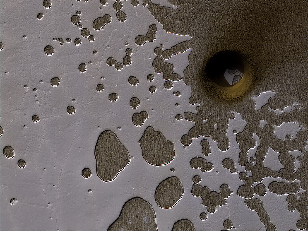
During late summer in the Southern hemisphere on Mars, the angle of the sunlight as it strikes the surface brings out some subtle details on the planet’s surface.
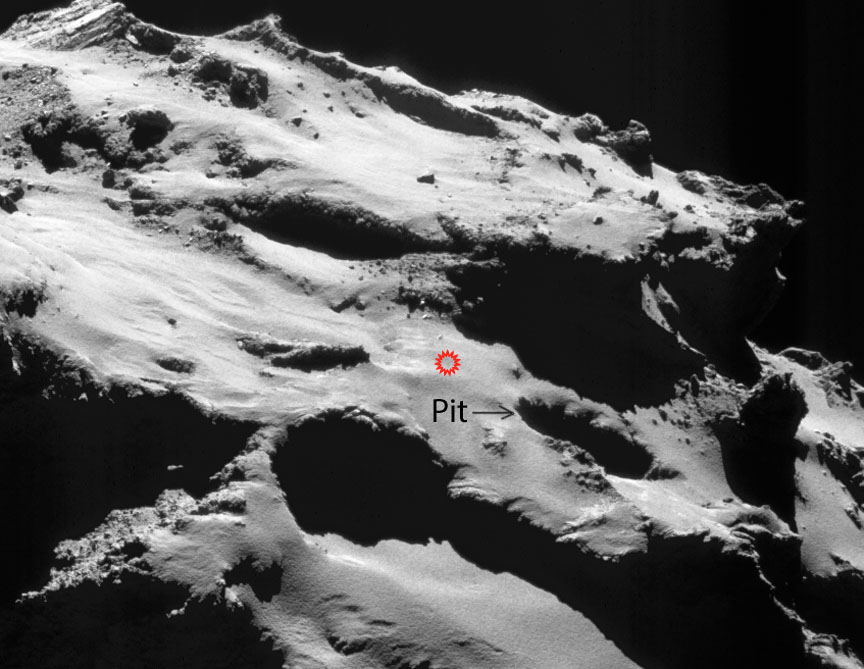
In this image, the HiRISE camera on board NASA’s Mars Reconnaissance Orbiter (MRO) captured an area of frozen carbon dioxide on the surface. Some of the carbon dioxide ice has melted, giving it a swiss-cheese appearance. But there is also an unusual hole or crater on the right side of the image, with some of the carbon dioxide ice clearly visible in the bottom of the pit.
NASA scientists are uncertain what exactly caused the unusual pit. It could be an impact crater, or it could be a collapsed pit caused by melting or sublimation of sub-surface carbon dioxide ice.
MRO has been in orbit around Mars for over 10 years, and has completed over 50,000 orbits. The MRO has two cameras. The CTX camera is lower resolution, and has imaged over 99% of the Martian surface. HiRISE is the high-resolution camera that is used to closely examine areas and objects of interest, like the unusual surface pit in this image.
Copyright: ESA with changes to annotations by the author
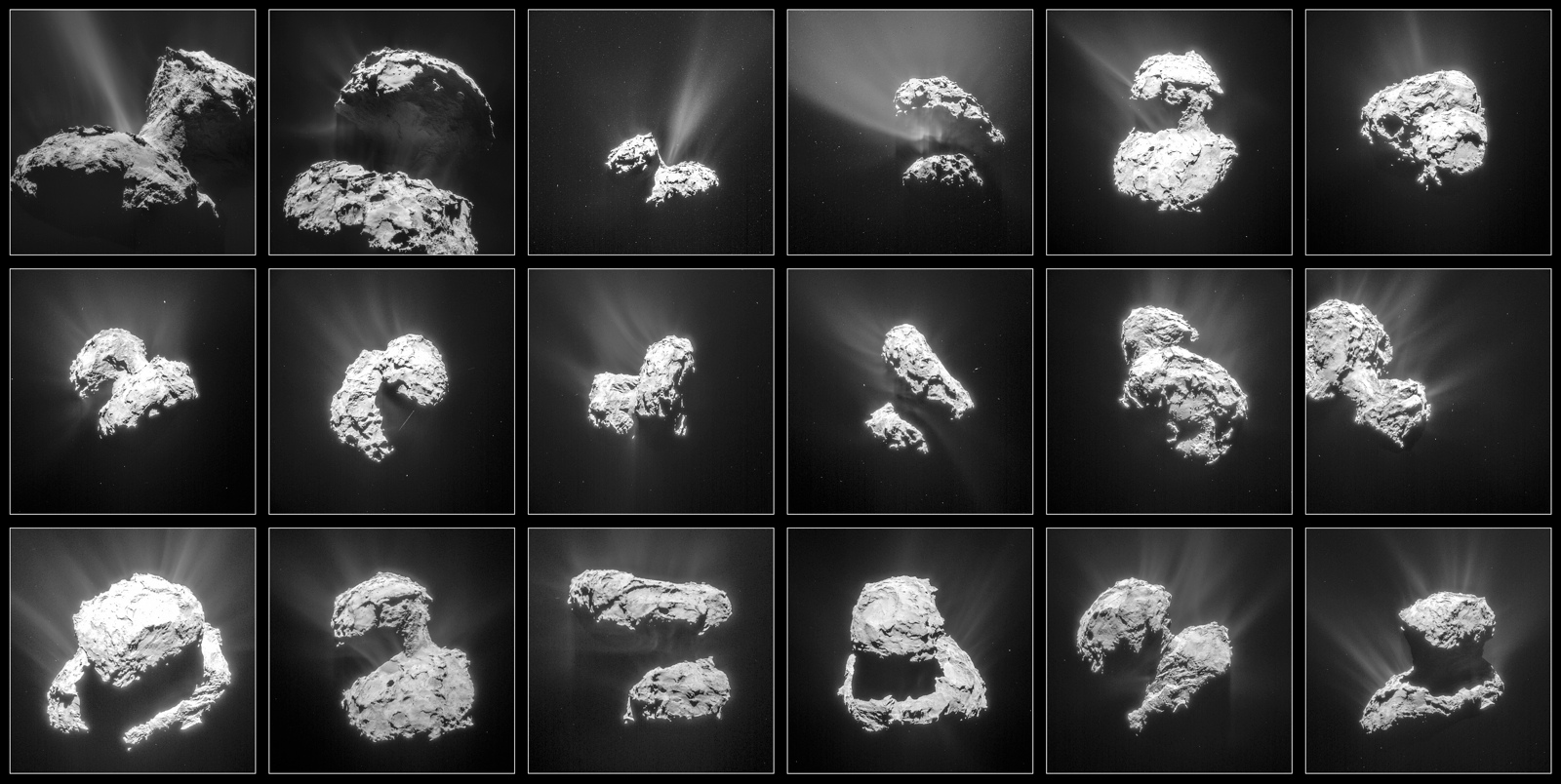
This montage of photos of Comet 67P/Churyumov-Gerasimenko was taken by ESA’s Rosetta spacecraft between Jan. 31 and March 25, 2015 and shows increasing activity as the comet approached perihelion. Credit: NAVCAM /CC-BY-SA-IGO-3.0
Rosetta awoke from a decade of deep-space hibernation in January 2014 and immediately got to work photographing, measuring and sampling comet 67P/C-G. On September 30 it will sleep again but this time for eternity. Mission controllers will direct the probe to impact the comet’s dusty-icy nucleus within 20 minutes of 10:40 Greenwich Time (6:40 a.m. EDT) that Friday morning. The high-resolution OSIRIS camera will be snapping pictures on the way down, but once impact occurs, it’s game over, lights out. Rosetta will power down and go silent.
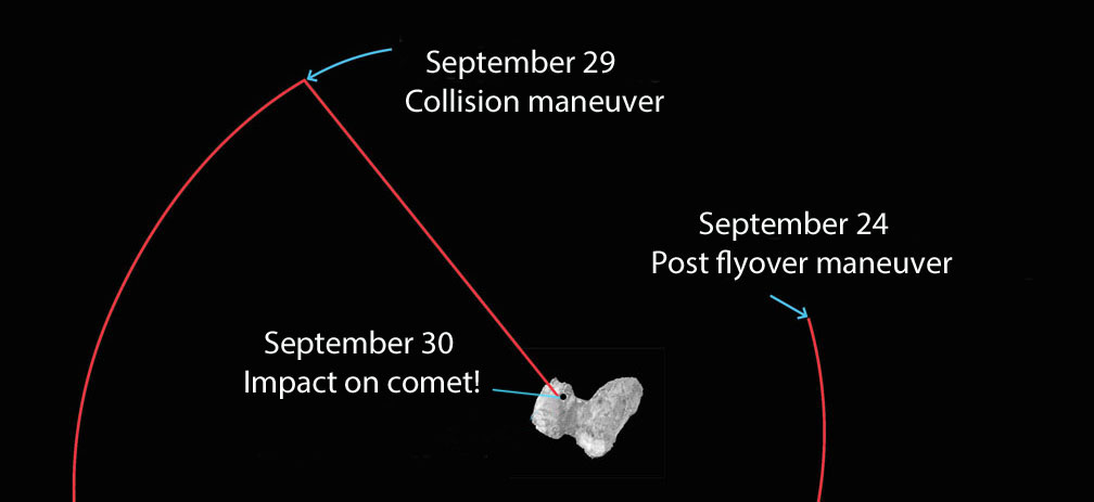
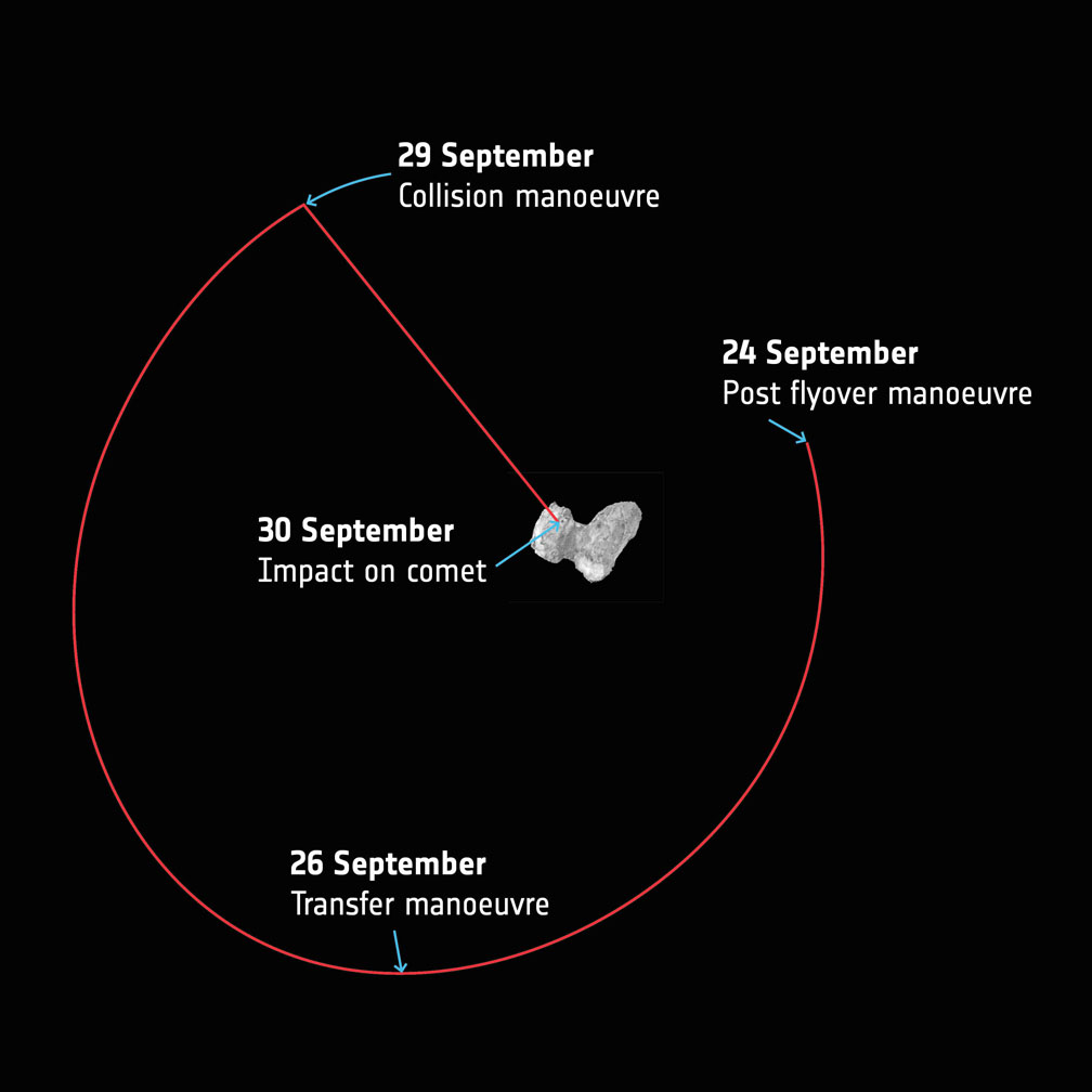
A simplified overview of Rosetta’s last week of maneuvers at Comet 67P/Churyumov–Gerasimenko. Starting today (Sept. 24) the spacecraft will leave the flyover orbits and transfer towards a 16 x 23 km orbit that will be used to prepare for the final descent. The collision course maneuver will take place in the evening Sept. 29 with impact expected to occur at 10:40 GMT (6:40 a.m. EDT), which taking into account the 40 minute signal travel time between Rosetta and Earth on Sept. 30, means the confirmation would be expected at mission control at 11:20 GMT (7:20 a.m. EDT). Copyright: ESA
Nearly three years have passed since Rosetta opened its eyes on 67P, this curious, bi-lobed rubber duck of a comet just 2.5 miles (4 km) across with landscapes ranging from dust dunes to craggy peaks to enigmatic ‘goosebumps’. The mission was the first to orbit a comet and dispatch a probe, Philae, to its surface. I think it’s safe to say we learned more about what makes comets tick during Rosetta’s sojourn than in any previous mission.
So why end it? One of the big reasons is power. As Rosetta races farther and farther from the Sun, less sunlight falls on its pair of 16-meter-long solar arrays. At mid-month, the probe was over 348 million miles (560 million km) from the Sun and 433 million miles (697 million km) from Earth or nearly as far as Jupiter. With Sun-to-Rosetta mileage increasing nearly 620,000 miles (1 million km) a day, weakening sunlight can’t provide the power needed to keep the instruments running.
Rosetta’s last orbits around the comet
Rosetta’s also showing signs of age after having been in the harsh environment of interplanetary space for more than 12 years, two of them next door to a dust-spitting comet. Both factors contributed to the decision to end the mission rather than put the probe back into an even longer hibernation until the comet’s next perihelion many years away.
Since August 9, Rosetta has been swinging past the comet in a series of ever-tightening loops, providing excellent opportunities for close-up science observations. On September 5, Rosetta swooped within 1.2 miles (1.9 km) of 67P/C-G’s surface. It was hoped the spacecraft would descend as low as a kilometer during one of the later orbits as scientists worked to glean as much as possible before the show ends.
Rosetta is targeted to land at the site within this planned impact ellipse in the Ma’at region on the comet’s smaller lobe. See below for a closer view. Credit: ESA/Rosetta/NAVCAM – CC BY-SA IGO 3.0
The final of 15 close flyovers will be completed today (Sept. 24) after which Rosetta will be maneuvered from its current elliptical orbit onto a trajectory that will eventually take it down to the comet’s surface on Sept. 30.
The beginning of the end unfolds on the evening of the 29th when Rosetta spends 14 hours free-falling slowly towards the comet from an altitude of 12.4 miles (20 km) — about 4 miles higher than a typical commercial jet — all the while collecting measurements and photos that will be returned to Earth before impact. The last eye-popping images will be taken from a distance of just tens to a hundred meters away.
The landing will be a soft one, with the spacecraft touching down at walking speed. Like Philae before it, it will probably bounce around before settling into place. Mission control expects parts of the probe to break upon impact.
Taking into account the additional 40 minute signal travel time between Rosetta and Earth on the 30th, confirmation of impact is expected at ESA’s mission control in Darmstadt, Germany, within 20 minutes of 11:20 GMT (7:20 a.m. EDT). The times will be updated as the trajectory is refined. You can watch live coverage of Rosetta’s final hours on ESA TV.
ESAHangout: Preparing for Rosetta’s grand finale
“It’s hard to believe that Rosetta’s incredible 12.5 year odyssey is almost over, and we’re planning the final set of science operations, but we are certainly looking forward to focusing on analyzing the reams of data for many decades to come,” said Matt Taylor, ESA’s Rosetta project scientist.
The spacecraft landing site is shown in red and located next to Deir el-Medina, a large pit (arrowed). Credit: ESA/Rosetta/NAVCAM – CC BY-SA IGO 3.0
Plans call for the spacecraft to impact the comet somewhere within an ellipse about 1,300 x 2,000 feet (600 x 400 meters) long on 67P’s smaller lobe in the region known as Ma’at. It’s home to several active pits more than 328 feet (100 meters) in diameter and 160-200 feet (50-60 meters) deep, where a number of the comet’s dust jets originate. The walls of the pits are lined with fascinating meter-sized lumpy structures called ‘goosebumps’, which scientists believe could be early ‘cometesimals’, the icy snowballs that stuck together to create the comet in the early days of our Solar System’s formation.
Close-up of a curious surface texture nicknamed ‘goosebumps’. The bumps are about 9 feet (3 meters) across and seen on very steep slopes and exposed cliff faces. They may represent the original balls of icy dust that glommed together to form comets 4.5 billion years ago. Credit: ESA/Rosetta/MPS for OSIRIS Team MPS/UPD/LAM/IAA/SSO/INTA/UPM/DASP/IDA
During free-fall, the spacecraft will target a point adjacent to a 425-foot (130 m) wide, well-defined pit that the mission team has informally named Deir el-Medina, after a structure with a similar appearance in an ancient Egyptian town of the same name. High resolution images should give us a spectacular view of these enigmatic bumps.
While we hate to see Rosetta’s mission end, it’s been a blast going for a 2-year-plus comet ride-along.
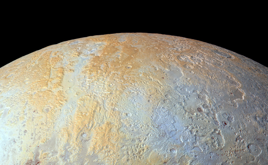
This enhanced color view Long canyons run vertically across the polar area—part of the informally named Lowell Regio, named for Percival Lowell, who founded Lowell Observatory and initiated the search that led to Pluto’s discovery. The widest of the canyons is about 45 miles (75 kilometers) wide and runs close to the north pole. Roughly parallel subsidiary canyons to the east and west are approximately 6 miles (10 kilometers) wide.
This enhanced color view shows long canyons running vertically across Pluto’s north polar region — part of the informally named Lowell Regio, named for Percival Lowell, who founded Lowell Observatory and initiated the search that led to Pluto’s discovery. The widest of the canyons is about 45 miles (75 km) wide and runs close to the north pole. Roughly parallel secondary canyons to the east and west are approximately 6 miles (10 km) wide. Click for a hi-res view. Credit: NASA/JHUAPL/SRI
Pluto’s frozen nitrogen custard “heart” has certainly received its share of attention. Dozens of wide and close-up photos homing on this fascinating region rimmed by mountains and badlands have been relayed back to Earth by NASA’s New Horizons probe after last July’s flyby. For being only 1,473 miles (2,370 km) in diameter, Pluto displays an incredible diversity of landscapes.
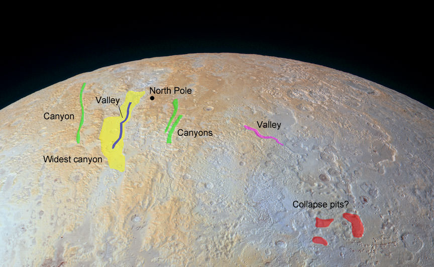
Annotated version showing sinuous valleys, canyons and depressions and irregular-shaped pits. Credit: NASA/JHUAPL/SRI with additional annotations by the author
This week, the New Horizons team shifted its focus northward, re-releasing an enhanced color image of the north polar area that was originally part of a high-resolution full-disk photograph of Pluto. Inside of the widest canyon, you can trace the sinuous outline of a narrower valley similar in outward appearance to the Moon’s Alpine Valley, cut by a narrow, curvy rill that once served as a conduit for lava.
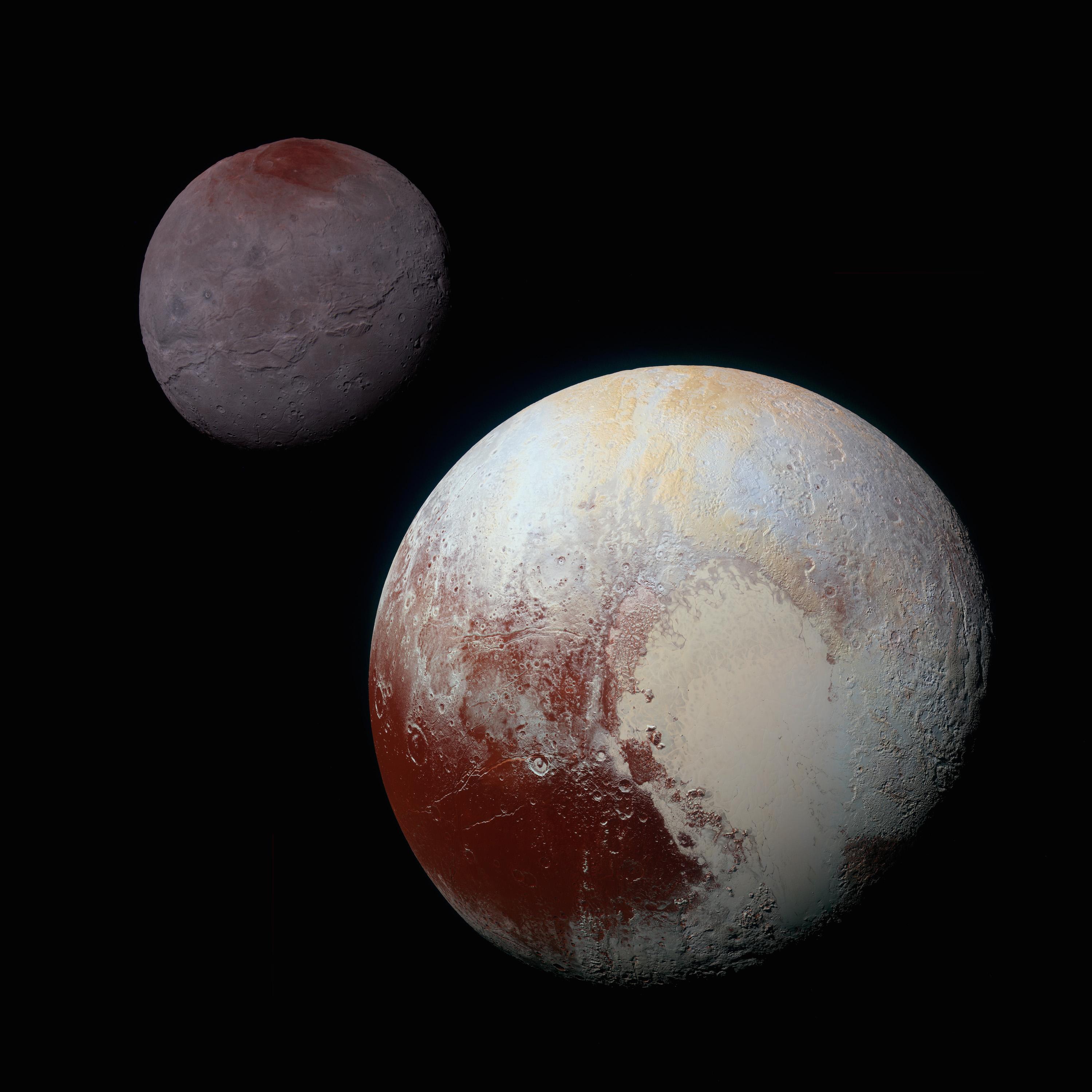
A composite of enhanced color images of Pluto (lower right) and Charon, taken by NASA’s New Horizons spacecraft on July 14, 2015. This image highlights the striking differences between Pluto and Charon. The color and brightness of both Pluto and Charon have been processed identically to allow direct comparison of their surface properties, and to highlight the similarity between Charon’s polar red terrain and Pluto’s equatorial red terrain. Pluto and Charon are shown with approximately correct relative sizes, but their separation is not to scale. Credit: NASA/JHUAPL/SRI
We see multiple canyons in Pluto’s polar region, their walls broken and degraded compared to canyons seen elsewhere on the planet. Signs that they may be older and made of weaker materials and likely formed in ancient times when Pluto was more tectonically active. Perhaps they’re related to that long-ago dance between Pluto and its largest moon Charon as the two transitioned into their current tidally-locked embrace.
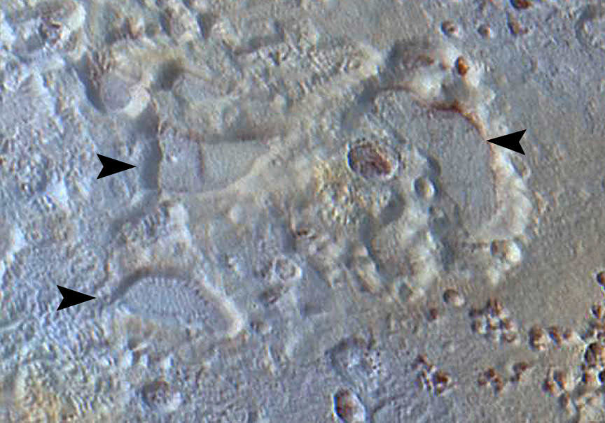
Cropped version with arrows pointing to three, odd-shaped pits that may reflect sinking of Pluto’s crust. Credit: NASA/JHUAPL/SRI
In the lower right corner of the image, check out those funky-shaped pits that resemble the melting outlines of boot prints in the snow. They reach 45 miles (70 km) across and 2.5 miles (4 km) deep and may indicate locations where subsurface ice has melted or sublimated (vaporized) from below, causing the ground to collapse.
Notice the variation in color across the landscape from yellow-orange to pale blue. High elevations show up in a distinctive yellow, not seen elsewhere on Pluto, with lower elevations and latitudes a bluish gray. New Horizons’ infrared measurements show abundant methane ice across the Lowell Region, with relatively little nitrogen ice. The yellow terrains may be older methane deposits that have been more processed by solar UV light than the bluer terrain. The color variations are especially striking in the area of the collapse pits.
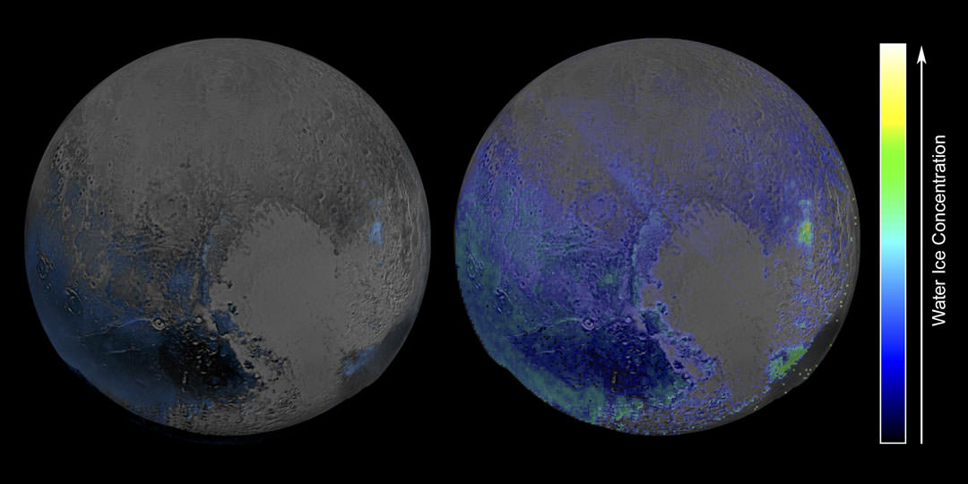
The new map shows exposed water ice at Pluto to be considerably more widespread across its surface than was previously known. Its greatest concentration lies in the red-hued regions (in visual light) to the west of Tombaugh Regio, the large, heart-shaped feature. Credit: NASA/JHUAPL/SRI
Pluto’s icy riches include not only methane and nitrogen but also water, which forms the planet’s bedrock. NASA poetically refers to the water ice as “the canvas on which (Pluto’s) more volatile ices paint their seasonally changing patterns”. Recent images made in infrared light shows little or no water ice in the informally named places called Sputnik Planum (the left or western region of Pluto’s “heart”) and Lowell Regio. This indicates that at least in these regions, Pluto’s bedrock remains well hidden beneath a thick blanket of other ices such as methane, nitrogen and carbon monoxide.
To delve more deeply into Pluto, visit the NASA’s photojournal archive, where you’ll find 130 photos (and counting!) of the dwarf planet and its satellites.
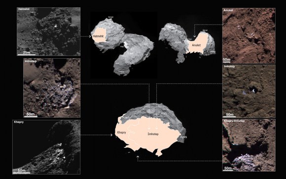
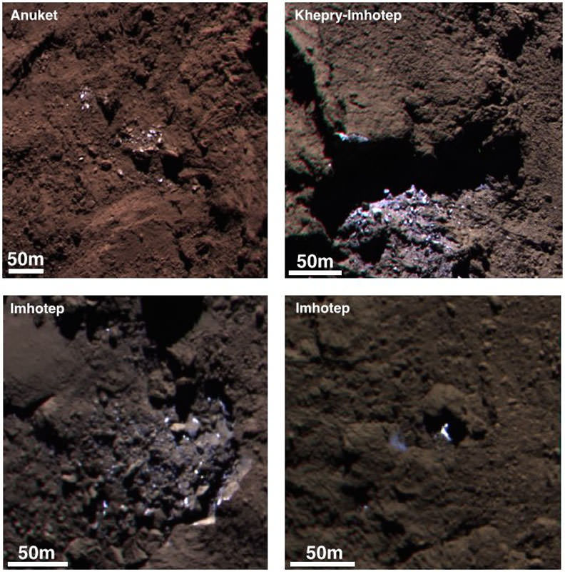
Example of a cluster of bright spots on Comet 67P/Churyumov-Gerasimenko found in the Khepry region. The bright patches are thought to be exposures of water-ice. Credit: ESA/Rosetta/MPS for OSIRIS Team MPS/UPD/LAM/IAA/SSO/INTA/UPM/DASP/IDA
Comet 67P/C-G may be tiny at just 2.5 miles (4 km) across, but its diverse landscapes and the processes that shape them astound. To say nature packs a lot into small packages is an understatement.
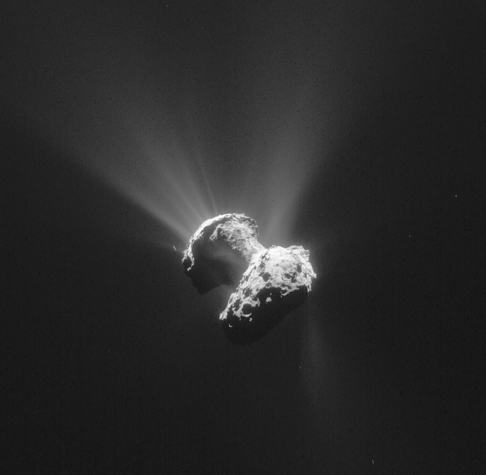
In newly-released images taken by Rosetta’s high-resolution OSIRIS science camera, the comet almost seems alive. Sunlight glints off icy boulders and pancaking sinkholes blast geysers of dust into the surrounding coma.
Examples of six different bright patches identified on the surface of 67P/C-G in images taken last September when Rosetta was 20-50 km from the comet. The center panel points to the broad regions in which they were discovered (not specific locations). 120 bright regions, including clusters of bright features, isolated features and individual boulders, were seen. The false color images were taken at different times and have been stretched and slightly saturated to emphasis color contrasts so that dark terrains appear redder and bright regions appear significantly bluer compared with what the human eye would normally see. Credit: SA/Rosetta/MPS for OSIRIS Team MPS/UPD/LAM/IAA/SSO/INTA/UPM/DASP/IDA
More than a hundred patches of water ice some 6 to 15 feet across (a few meters) dot the comet’s surface according to a new study just published in the journal Astronomy & Astrophysics. We’ve known from previous studies and measurements that comets are rich in ice. As they’re warmed by the Sun, ice vaporizes and carries away embedded dust particles that form the comet’s atmosphere or coma and give it a fuzzy appearance.
Examples of icy bright patches and clusters seen in September 2014. The two left hand images are crops of OSIRIS narrow-angle camera images acquired on September 5; the right hand images are from September 16. During this time the spacecraft was about 19-25 miles (30-40 km) from the comet center. Credit: ESA/Rosetta/MPS for OSIRIS Team MPS/UPD/LAM/IAA/SSO/INTA/UPM/DASP/IDA
Not all that fine powder leaves the comet. Some settles back to the surface, covering the ice and blackening the nucleus. This explains why all the comets we’ve seen up close are blacker than coal despite being made of material that’s as bright as snow.
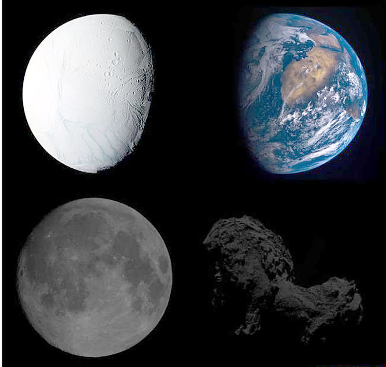
True brightness comparisons of four different Solar System bodies. At top are Saturn’s moon Enceladus and Earth. At bottom are the Moon and Comet 67P. Enceladus’ ice-covered surface makes it one of the brightest objects in the Solar System. In contrast, 67P is one of the darkest, its icy surface coated in dark mineral dust and organic compounds. Credit: ESA
Scientists have identified 120 regions on the surface of Comet 67P/Churyumov-Gerasimenko that are up to ten times brighter than the average surface brightness. Some are individual boulders, while others form clusters of bright specks. Seen in high resolution, many appear to be boulders with exposures of ice on their surfaces; the clusters are often found at the base of overhanging cliffs and likely got there when cliff walls collapsed, sending an avalanche of icy rocks downhill and exposing fresh ice not covered by dark dust.
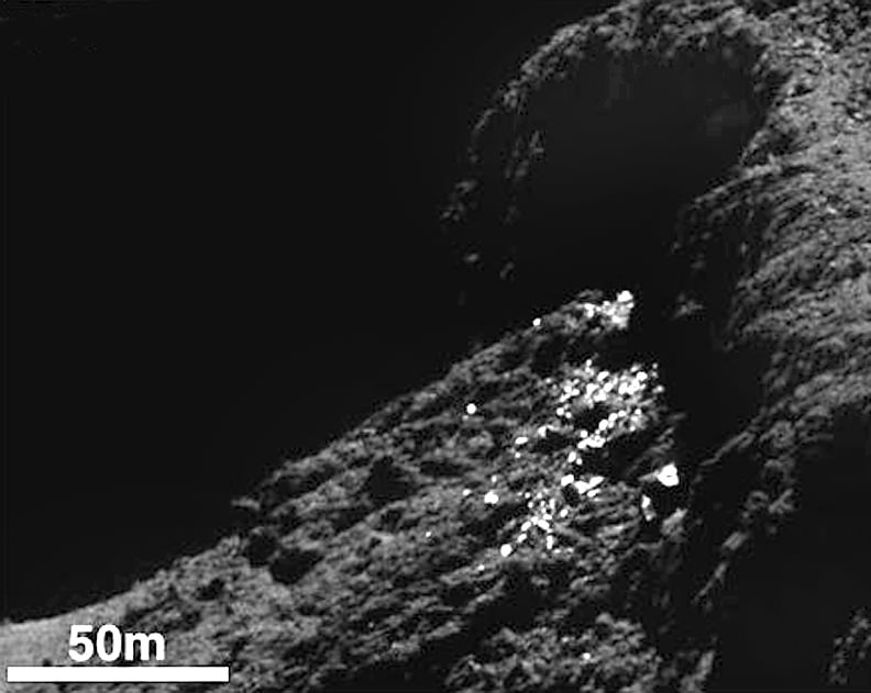
An individual boulder about 12 feet across with bright patches on its surface in the Hatmehit region. Credit: ESA/Rosetta/MPS for OSIRIS Team MPS/UPD/LAM/IAA/SSO/INTA/UPM/DASP/IDA
More intriguing are the isolated boulders found here and there that appear to have no relation to the surrounding terrain. Scientists think they arrived George Jetson style when they were jetted from the comet’s surface by the explosive vaporization of ice only to later land in a new location. The comet’s exceedingly low gravity makes this possible. Let that image marinate in your mind for a moment.
All the ice-glinting boulders seen thus far were found in shadowed regions not exposed to sunlight, and no changes were observed in their appearance over a month’s worth of observations.
“Water ice is the most plausible explanation for the occurrence and properties of these features,” says Antoine Pommerol of the University of Bern and lead author of the study.
How do we know it’s water ice and not CO2 or some other form of ice? Easy. When the observations were made, water ice would have been vaporizing at the rate of 1 mm per hour of solar illumination. By contrast, carbon monoxide or carbon dioxide ice, which have much lower freezing points, would have rapidly sublimated in sunlight. Water ice vaporizes much more slowly in comparison.
Lab tests using ice mixed with different minerals under simulated sunlight revealed that it only took a few hours of sublimation to produce a dust layer only a few millimeters thick. But it was enough to conceal any sign of ice. They also found that small chunks of dust would sometimes break away to expose fresh ice beneath.
“A 1 mm thick layer of dark dust is sufficient to hide the layers below from optical instruments,” confirms Holger Sierks, OSIRIS principal investigator at the Max Planck Institute for Solar System Research.
Comet 67P/C-G on June 21, 2015. The nucleus is a mixture of frozen ices and dust. As the comet approaches the Sun, sunlight warms its surface, causing the ices to boil away. This gas streams away carrying along large amounts of dust, and together they build up the coma. Copyright: ESA/Rosetta/NavCam – CC BY-SA IGO 3.0
It appears then that Comet 67P’s surface is mostly covered in dark dust with small exposures of fresh ice resulting from changes in the landscape like crumbling cliffs and boulder-tossing from jet activity. As the comet approaches perihelion, some of that ice will become exposed to sunlight while new patches may appear. You, me and the Rosetta team can’t wait to see the changes.
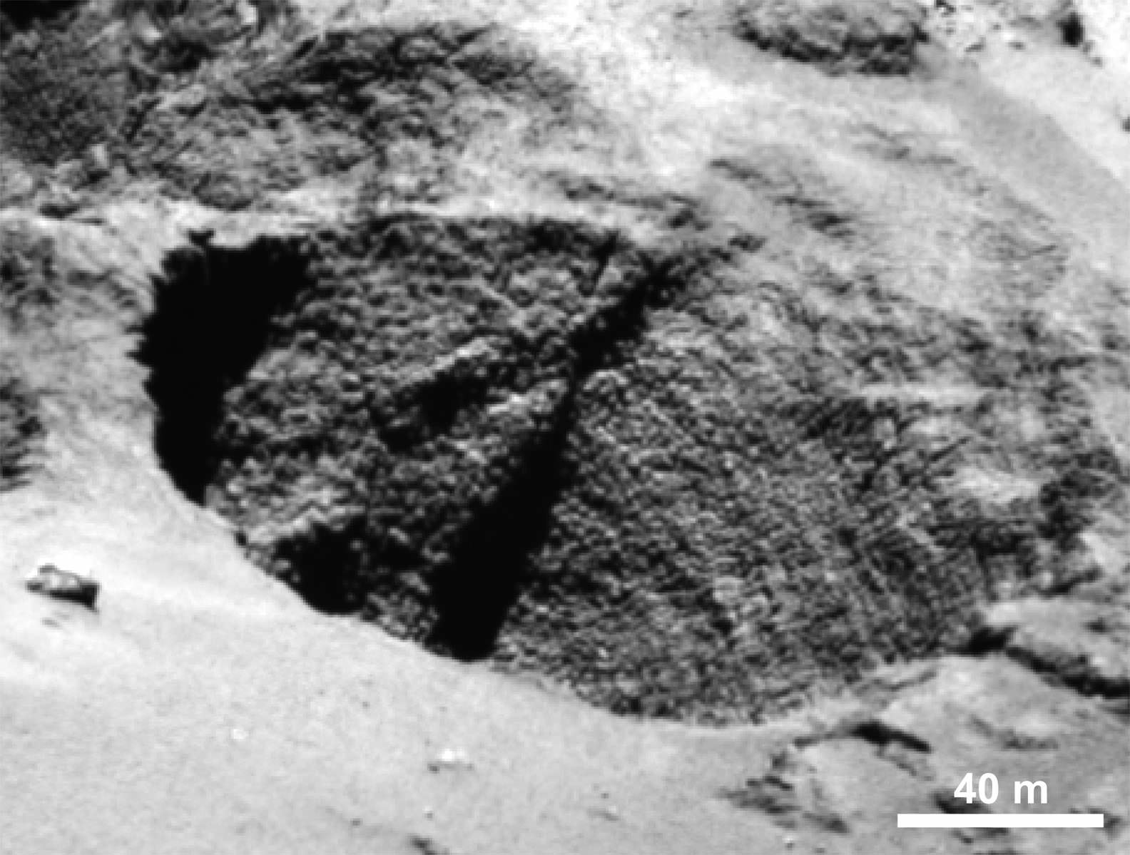
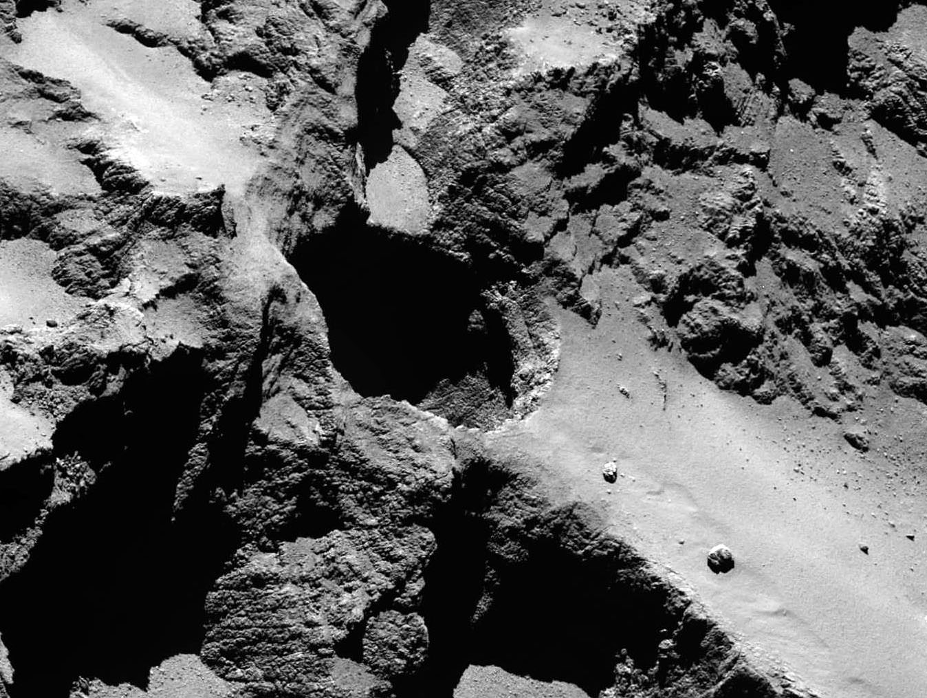
High-resolution view of an active pit photographed last September from a distance of about 16 miles (26 km) from the comet’s surface in the Seth region. The image scale is about 45 cm a pixel. The Seth_01 pit measures approximately 720 feet (220 m) across and 605 feet (85 m) deep. Note the smooth deposits of dust around the pit. Credit: ESA/Rosetta/MPS for OSIRIS Team MPS/UPD/LAM/IAA/SSO/INTA/UPM/DASP/IDA
Ever wonder how a comet gets its jets? In another new study appearing in the science journal Nature, a team of researchers report that 18 active pits or sinkholes have been identified in the comet’s northern hemisphere. These roughly circular holes appear to be the source of the elegant jets like those seen in the photo above. The pits range in size from around 100 to 1,000 feet (30-100 meters) across with depths up to 690 feet (210 meters). For the first time ever, individual jets can be traced back to specific pits.
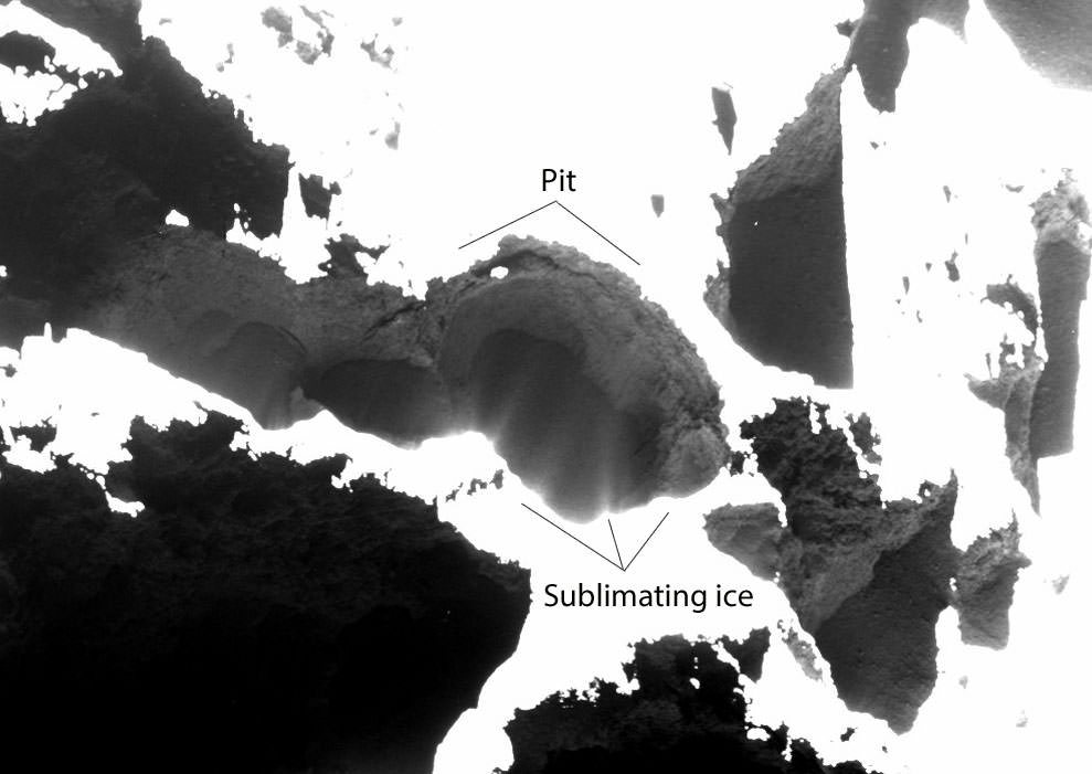
In specially processed photos, material can be seen streaming from inside pit walls like snow blasting from a snowmaking machine. Incredible!
Active pits detected in the Seth region of the comet. The contrast of the image has been stretched to reveal the details of the fine-structured jets against the shadow of the pit, which are interpreted as dusty streams rising from the fractured wall of the pit. The image was acquired on October 20, 2014 from a distance of 4.3 miles (7 km) from the surface of the comet. Credit: ESA/Rosetta/MPS for OSIRIS Team MPS/UPD/LAM/IAA/SSO/INTA/UPM/DASP/IDA
“We see jets arising from the fractured areas of the walls inside the pits. These fractures mean that volatiles trapped under the surface can be warmed more easily and subsequently escape into space,” said Jean-Baptiste Vincent from the Max Planck Institute for Solar System Research, lead author of the study.
Similar to the way sinkholes form on Earth, scientists believe pits form when the ceiling of a subsurface cavity becomes too thin to support its own weight. With nothing below to hold it place, it collapses, exposing fresh ice below which quickly vaporizes. Exiting the hole, it forms a collimated jet of dust and gas.
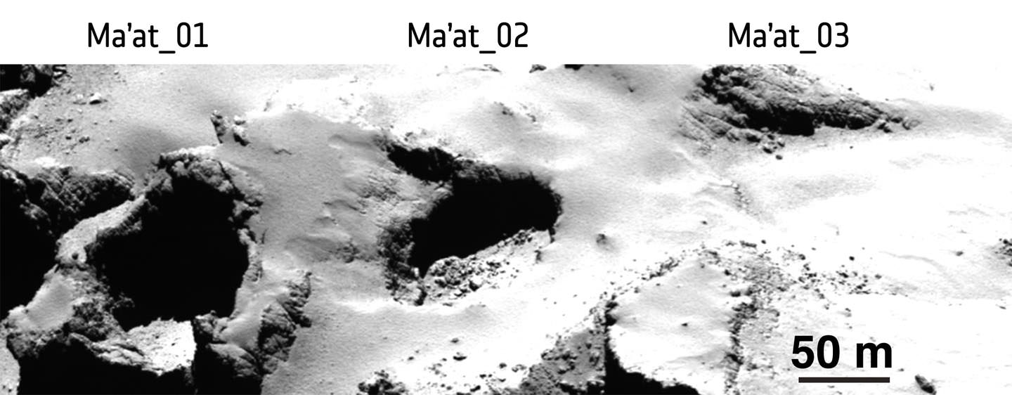
Pits Ma’at 1, 2 and 3 show differences in appearance that may reflect their history of activity. While pits 1 and 2 are active, no activity has been observed from pit 3. The young, active pits are very steep-sided; pits without any observed activity are shallower and seem to be filled with dust. Middle-aged pits tend to have boulders on their floors from mass-wasting of the sides. Credits: ESA/Rosetta/MPS for OSIRIS Team MPS/UPD/LAM/IAA/SSO/INTA/UPM/DASP/IDA
The paper’s authors suggest three ways for pits to form:
* The comet may contain voids that have been there since its formation. Collapse could be triggered by either vaporizing ice or seismic shaking when boulders ejected elsewhere on the comet land back on the surface.
* Direct sublimation of pockets of volatile (more easily vaporized) ices like carbon dioxide and carbon monoxide below the surface as sunlight warms the dark surface dust, transferring heat below.
* Energy liberated by water ice changing its physical state from amorphous to its normal crystalline form and stimulating the sublimation of the surrounding more volatile carbon dioxide and carbon monoxide ices.
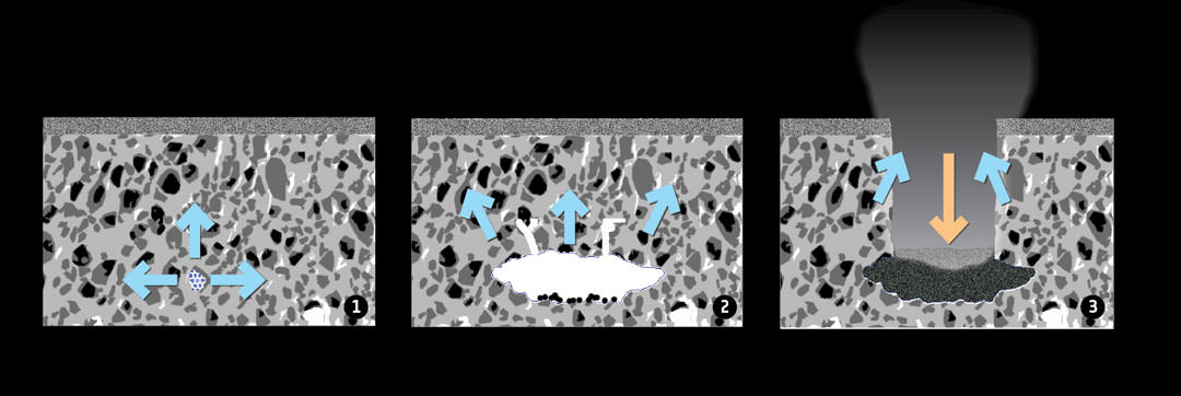
Graphic showing how pits may form through sinkhole collapse in the comet’s dusty surface layer covering a mixture of dust and ices. 1. Heat causes subsurface ices to sublimate (blue arrows), forming a cavity. 2.When the ceiling becomes too weak to support its own weight, it collapses, creating a deep, circular pit (orange arrow). Newly exposed material in the pit walls sublimates (blue arrows). Credit: ESA/Rosetta/J-B Vincent et al (2015)
The researchers think they can use the appearance of the sinkholes to age-date different parts of the comet’s surface — the more pits there are in a region, the younger and less processed the surface there is. They point to 67P/C-G’s southern hemisphere which receives more energy from the Sun than the north and at least for now, shows no pit structures.
The most active pits have steep sides, while the least show softened contours and are filled with dust. It’s even possible that a partial collapse might be the cause of the occasional outbursts when a comet suddenly brightens and enlarges as seen from Earth. Rosetta observed just such an outburst this past April. And these holes can really kick out the dust! It’s estimated a typical full pit collapse releases a billion kilograms of material.
With Rosetta in great health and perihelion yet to come, great things lie ahead. Maybe we’ll witness a new sinkhole collapse, an icy avalanche or even levitating boulders!
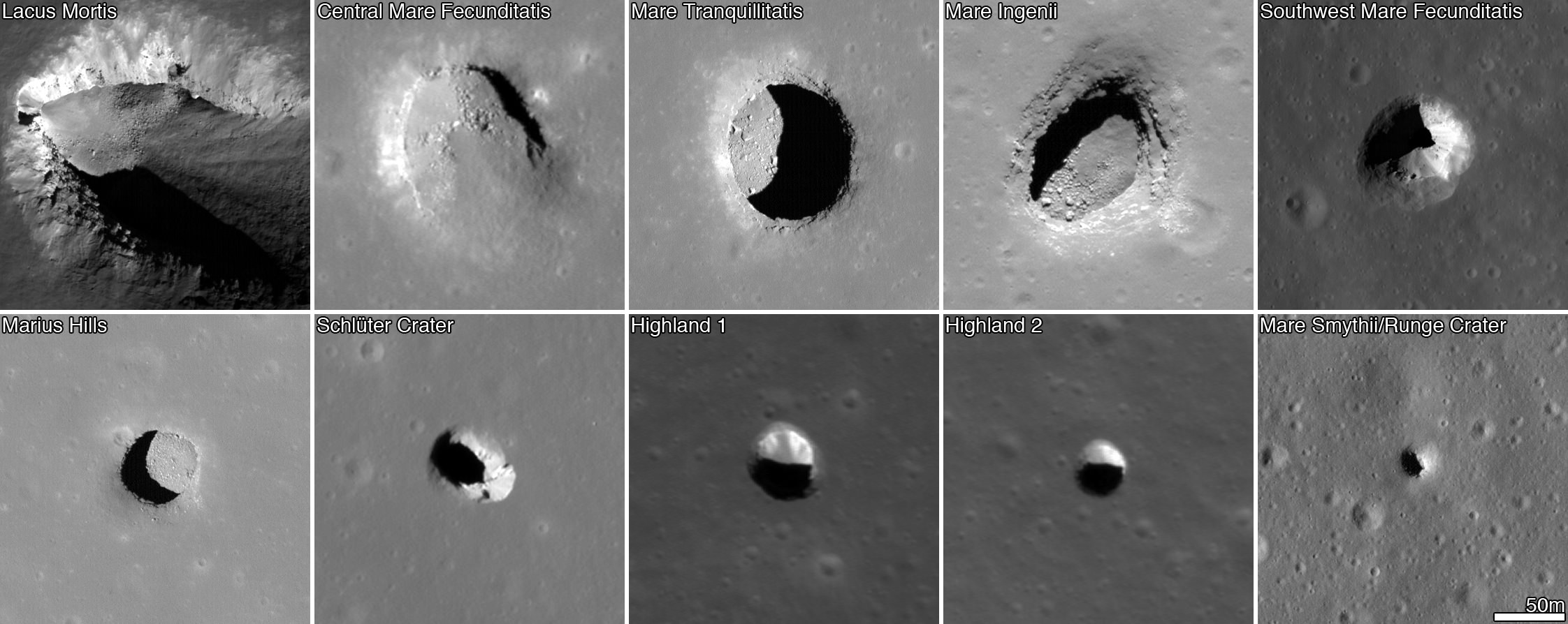
Images from the Lunar Reconaissance Orbiter showing pits on the lunar surface. The images are each 222 meters (728 feet) wide. Credit: NASA/GSFC/Arizona State University
Just look at that new video from NASA showing the first moon landing site in three dimensions. It’s tempting to touch on the surface nearby the Eagle lander there in the center and do some prospecting.
You’ll notice a lot of craters in that video, which is based on Lunar Reconnaissance Orbiter data. Across the moon’s surface, a separate study saw the spacecraft investigate 200 extremely steep-walled craters, known as “pits”.
These would be fascinating places to send astronauts for scientific study. Not only that, they’re actually one of the safest spots possible on the moon, according to a new study.
“Pits would be useful in a support role for human activity on the lunar surface,” stated lead researcher Robert Wagner of Arizona State University.
“A habitat placed in a pit — ideally several dozen meters back under an overhang — would provide a very safe location for astronauts: no radiation, no micrometeorites, possibly very little dust, and no wild day-night temperature swings.”
And if you look at the picture below, you can see at least one of those pits is in the Sea of Tranquility — the approximate landing area where Apollo 11 touched down 45 years ago this week. The pits were found mainly using a computer algorithm that scanned LRO photos, although a few of the craters were previously identified with the Japanese Kaguya spacecraft.
Large craters or lunar “seas” (ancient, solidified lava flows) are the locations where most of these pits are found. How they were formed is being investigated, but there are some hypotheses. Perhaps a meteorite impact caused a collapse, or perhaps molten rock flows under the surface gradually lost their lava, leaving voids.
Lunar Reconnaissance Orbiter. Image Credit: NASA
To learn more, the researchers say more LRO images would be great (only 40% of the surface imaged had the appropriate lighting conditions for this study) and in the future, we’d need to get much closer-up than pictures taken from orbit.
“The ideal follow-up, of course, would be to drop probes into one or two of these pits, and get a really good look at what’s down there,” added Wagner.
“Pits, by their nature, cannot be explored very well from orbit — the lower walls and any floor-level caves simply cannot be seen from a good angle. Even a few pictures from ground-level would answer a lot of the outstanding questions about the nature of the voids that the pits collapsed into. We’re currently in the very early design phases of a mission concept to do exactly this, exploring one of the largest mare pits.”
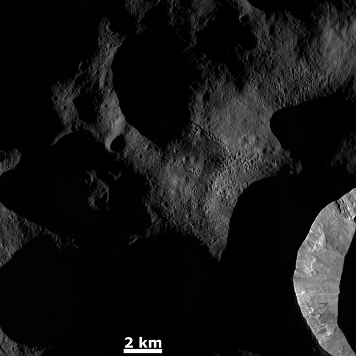
Vesta's surface textures get highlighted by dawn's light
[/caption]
Sunrise on Vesta highlights the asteroid’s varied surface textures in this image from NASA’s Dawn spacecraft, released on Monday, Feb. 20. The image was taken on Dec. 18 with Dawn’s Framing Camera (FC).
Just as the low angle of early morning sunlight casts long shadows on Earth, sunrise on Vesta has the same effect — although on Vesta it’s not trees and buildings that are being illuminated but rather deep craters and chains of pits!
The steep inner wall of a crater is seen at lower right with several landslides visible, its outer ridge cutting a sharp line.
Chains of pits are visible in the center of the view. These features are the result of ejected material from an impact that occurred outside of the image area.
Other lower-profile, likely older craters remain in shadow.
Many of these features would appear much less dramatic with a high angle of illumination, but they really shine brightest in dawn’s light.