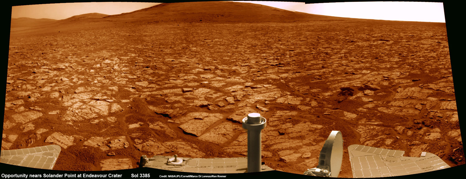
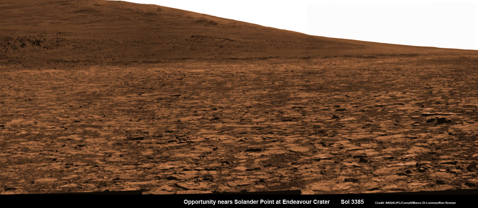
Opportunity rover’s 1st mountain climbing goal is dead ahead in this up close view of Solander Point along the eroded rim of Endeavour Crater. Opportunity will soon ascend the mountain in search of minerals signatures indicative of a past Martian habitable environment. This navcam panoramic mosaic was assembled from raw images taken on Sol 3385 (Aug 2, 2013). Credit: NASA/JPL/Cornell/Marco Di Lorenzo/Ken Kremer (kenkremer.com)
Opportunity rover’s 1st mountain climbing goal is dead ahead in this up close view of Solander Point at Endeavour Crater. Opportunity will ascend the mountain looking for clues indicative of a Martian habitable environment. This navcam panoramic mosaic was assembled from raw images taken on Sol 3385 (Aug 2, 2013).
Credit: NASA/JPL/Cornell/Marco Di Lorenzo/Ken Kremer (kenkremer.com)[/caption]
NASA’s most powerful Mars orbiter has been given the green light today (Aug. 5) to capture new high resolution spectral scans that are absolutely crucial for directing the long lived Opportunity rover’s hunt for signatures of habitability atop the intriguing mountain she will soon ascend.
In a plan only recently approved by NASA, engineers are aiming the CRISM mineral mapping spectrometer aboard the Mars Reconnaissance Orbiter (MRO) circling overhead to collect high resolution survey scans of Solander Point – Opportunity’s 1st mountain climbing goal along the rim of huge Endeavour Crater.
“New CRISM observations centered over Solander Point will be acquired on Aug. 5, 2013,” Ray Arvidson told Universe Today exclusively. Arvidson is the mission’s deputy principal scientific investigator from Washington University in St. Louis, Mo.
NASA’s decade old rover Opportunity is about to make ‘landfall’ at the base of Solander Point, the Martian mountain she will scale in search of the chemical ingredients that could sustain Martian microbes.
So the new spectral data can’t come back to Earth soon enough.
Currently, the science team lacks the same quality of high resolution CRISM data from Solander Point that they had at a prior stop at Cape York. And that data was crucial because it allowed the rover to be precisely targeted – and thereby discover a habitable zone, Arvidson told me.
“CRISM collected lots of overlapping measurements at Cape York to sharpen the image resolution to 5 meters per pixel to find the phyllosilicate smectite [clay minerals] signatures at Matejivic Hill on Cape York.”
“We don’t have that at Solander Point. We only have 18 meters per pixel data. And at that resolution you can’t tell if the phyllosilicate smectite [clay minerals] outcrops are present.”
Today’s new survey from Mars orbit will vastly improve the spectral resolution – from 18 meters per pixel down to 5 meters per pixel.
“5 meter per pixel CRISM resolution is expected in the along-track direction over Solander Point by commanding the gimbaled optical system to oversample that much,” Arvidson explained.
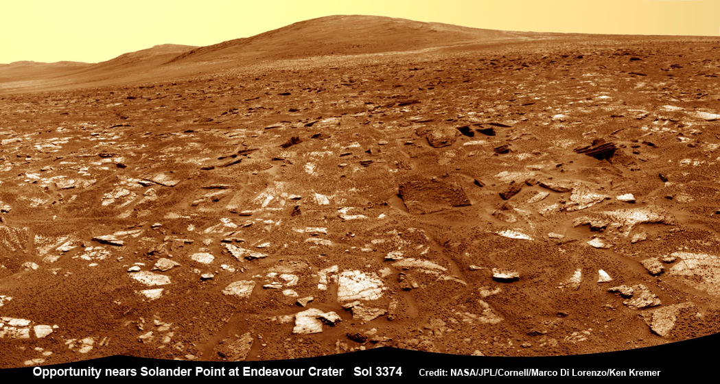
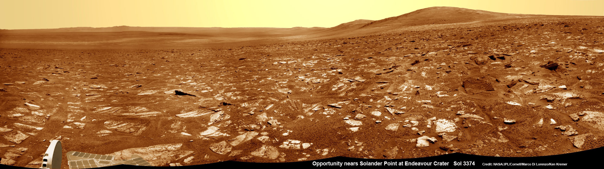
Opportunity rover’s view from very near the foothills of Solander Point looking along the rim and vast expanse of Endeavour Crater. Solander Point is the 1st Martian Mountain NASA’s Opportunity will climb and the rovers next destination. Solander Point may harbor clay minerals indicative of a past Martian habitable environment. This navcam mosaic was assembled from raw images taken on Sol 3374 (July 21, 2013). Credit: NASA/JPL/Cornell/Marco Di Lorenzo/Ken Kremer (kenkremer.com)
The new CRISM spectral survey from Mars is essential to enable the science team to carefully study the alien, unexplored terrain in detail and locate the clay minerals and other water bearing minerals, even before the rover arrives.
Clay minerals form in neutral pH water conducive to life.
Opportunity would then be commanded to drive to preselected sites to conduct “ground truth” forays at Solander.
That’s just like was done at Cape York and the “Esperance” rock loaded with clay minerals that turned into one of the “Top 5 discoveries of the mission” according to Arvidson and Steve Squyres, Opportunity’s Science Principal Investigator of Cornell.
But it took some cajoling and inter team negotiations to convince everyone to move forward with the special but crucial CRISM imaging plan.
Since MRO is getting on in age – it launched in 2005 – NASA and the spacecraft managers have to carefully consider special requests such as this one which involves slewing the MRO spacecraft instruments and therefore entails some health risks to the vehicle.
“CRISM has been operating at Mars since 2006 and sometimes the optics on a gimble have actuators that get stuck a little bit and don’t sweep as fully as planned.”
Nevertheless, Arvidson told me a few weeks ago he was hopeful to get approval.
“I suspect I can talk the team into it.”
And eventually he did! And informed me for the readers of Universe Today.
The fact that the Opportunity scientists already scored a ‘Science Home Run’ with their prior CRISM targeting request at Cape York certainly aided their cause immensely.
The new approved CRISM measurements due to be captured today will give Opportunity the best chance to be targeted to the most promising mineral outcrops, and as quickly as possible.
“With the coordinated observations from CRISM and Opportunity we will go into Solander Point a lot smarter!”
“And we’ll have a pretty good idea of what to look for and where,” Arvidson told me.
Opportunity snap up close view of the base of Solander Point and mountain slopes she will ascend soon. This hi res pancam camera mosaic was assembled from raw images taken on Sol 3385 (Aug 2, 2013). Credit: NASA/JPL/Cornell/ASU/Marco Di Lorenzo/Ken Kremer (kenkremer.com)
Today marks Opportunity’s 3389th Sol or Martian day roving Mars. Merely 90 days were expected!
Having completed her investigation of the rocky crater plains, the rover continues to drive south.
Any day now Opportunity will drive onto the Bench surrounding Solander and start a new phase of the mission.
Since she basically arrived at Solander with plenty of power and ahead of schedule prior to the onset of the 6th Martian winter, the robot has some spare time to investigate the foothills before ascending the north facing slopes.
“We will be examining the bench and then working our way counterclockwise to reach the steep slopes associated with the Noachian outcrops that are part of the Endeavour rim,” Arvidson said.
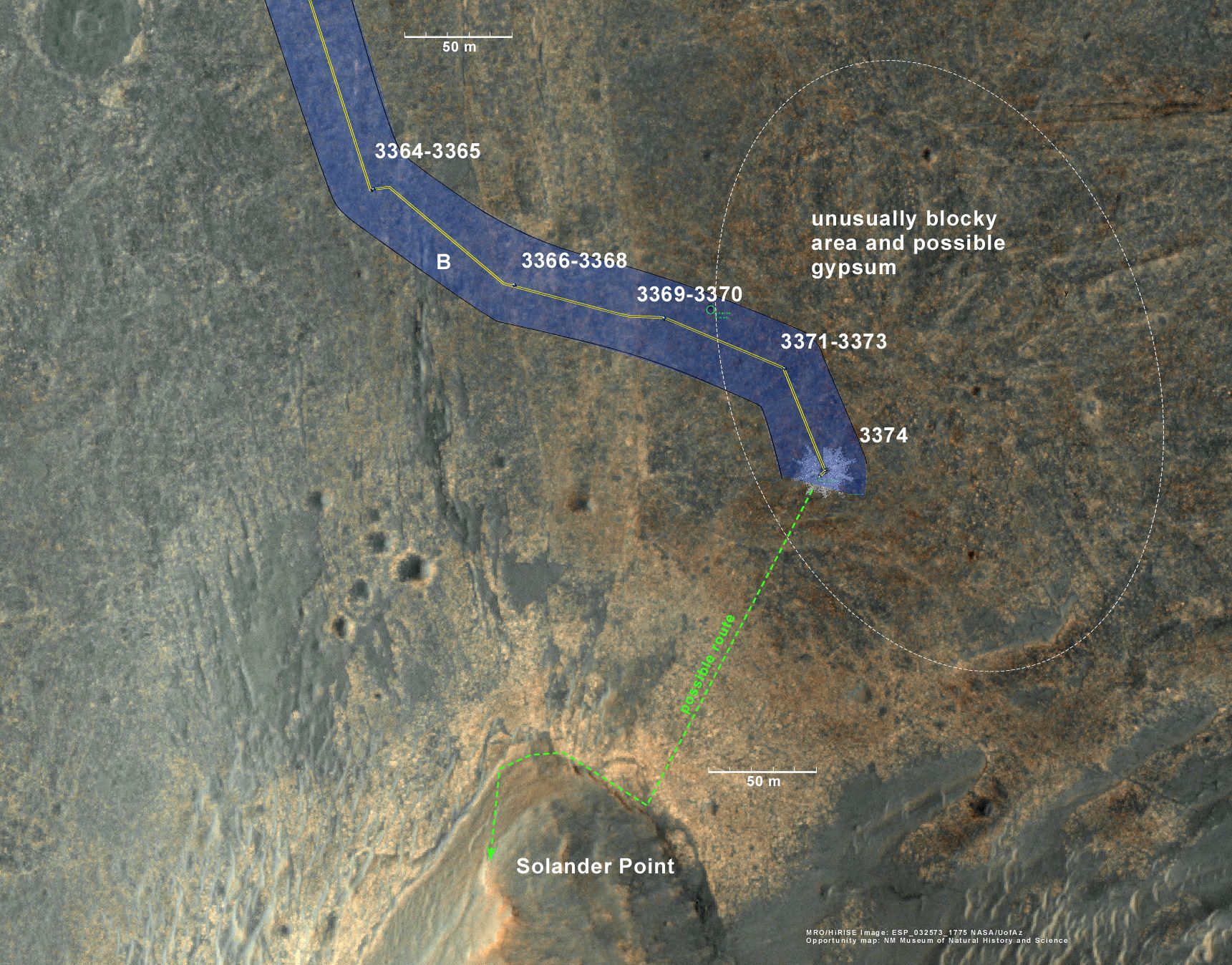
Ken Kremer Opportunity rover location in the latest MRO/HiRISE color image. The green line shows more or less the route we hope to take to the base of Solander point. Since it is only a couple of hundred meters away, we could be there is a couple of drives. Maybe by the end of next week. The label say “3374” but this is also roughly the location through 3379. Credit: NASA/JPL/Larry Crumpler
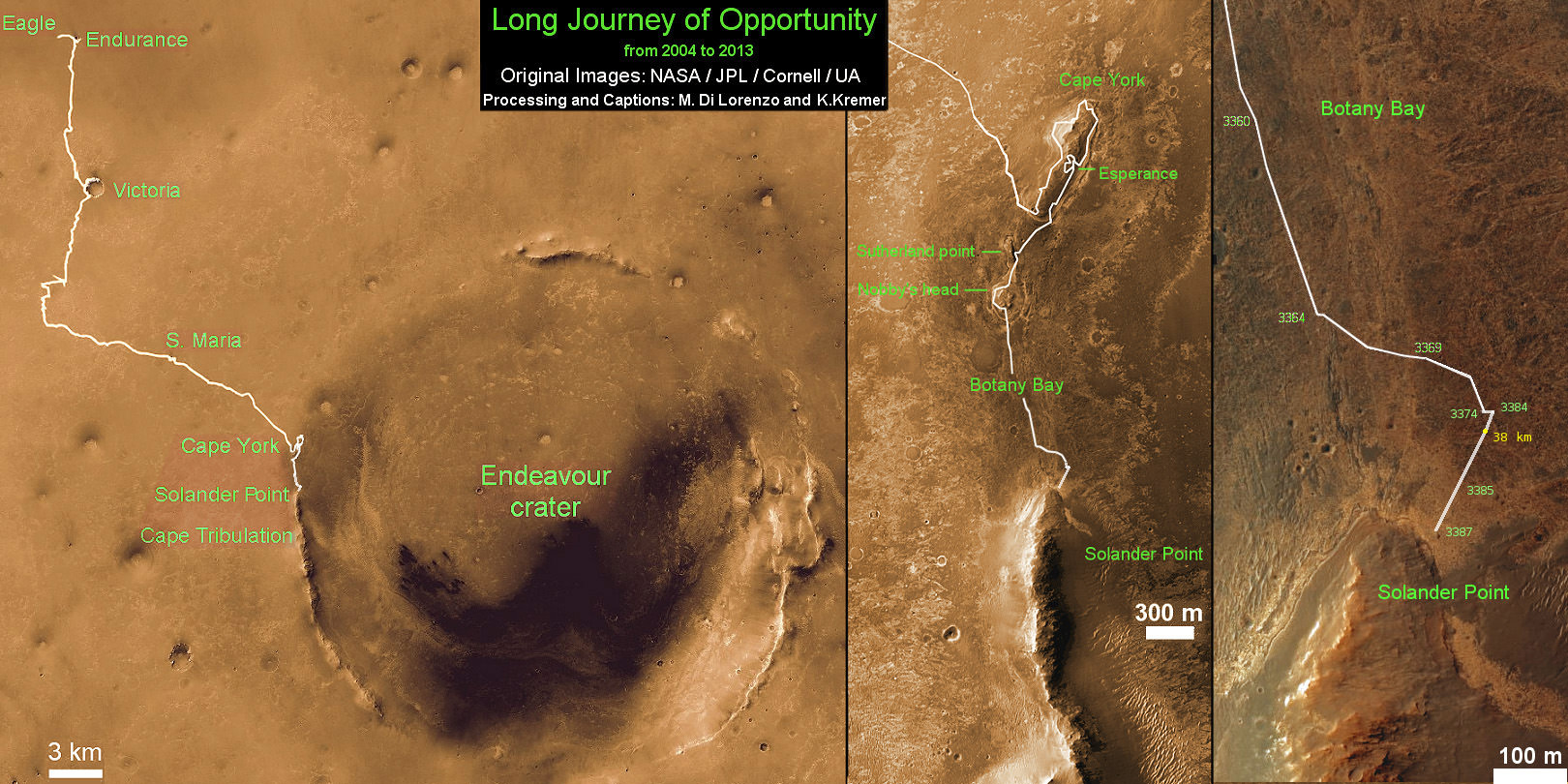
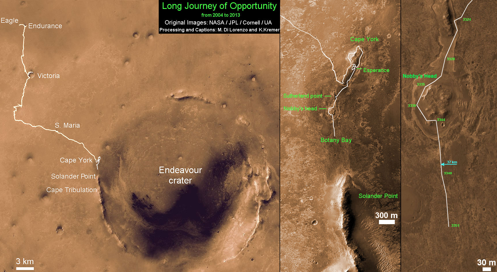
Traverse Map for NASA’s Opportunity rover from 2004 to 2013
This map shows the entire path the rover has driven during more than 9 years and over 3387 Sols, or Martian days, since landing inside Eagle Crater on Jan 24, 2004 to current location near foothills of Solander Point at the western rim of Endeavour Crater. Opportunity discovered clay minerals at Esperance – indicative of a habitable zone. Credit: NASA/JPL/Cornell/ASU/Marco Di Lorenzo/Ken Kremer
Opportunity rover’s view from very near the foothills of Solander Point looking along the rim and vast expanse of Endeavour Crater. Solander Point is the 1st Martian Mountain NASA’s Opportunity will climb and the rovers next destination. Solander Point may harbor clay minerals indicative of a past Martian habitable environment. This navcam mosaic was assembled from raw images taken on Sol 3374 (July 21, 2013). Credit: NASA/JPL/Cornell/Marco Di Lorenzo/Ken Kremer (kenkremer.com) See complete panoramic mosaic below
Opportunity rover’s view from very near the foothills of Solander Point looking along the rim and vast expanse of Endeavour Crater. This area exhibits gypsum signatures and numerous blocks of intriguing rock. Solander Point is the 1st Martian Mountain NASA’s Opportunity will climb and the rovers next destination. Solander Point may harbor clay minerals indicative of a past Martian habitable environment. This navcam mosaic was assembled from raw images taken on Sol 3374 (July 21, 2013). Credit: NASA/JPL/Cornell/Marco Di Lorenzo/Ken Kremer (kenkremer.com).
See complete panoramic mosaic below. Story updated with further details[/caption]
Exactly a decade after blasting off for the Red Planet and discovering a wide swath of water altered rocks and minerals in the ensuing years by exploring countless craters large and small, NASA’s intrepid Opportunity rover is just days away from arriving at her next big quest – a Martian mountain named Solander Point that may possess the key chemical ingredients necessary to sustain Martian life forms.
“We are parked 200 meters away from the bench at Solander Point,” Ray Arvidson told Universe Today exclusively. Arvidson is the mission’s deputy principal scientific investigator from Washington University in St. Louis, Mo. Furthermore, this area exhibits signatures related to water flow.
Solander Point also represents ‘something completely different’ – the first mountain the intrepid robot will ever climb.
“This will be Opportunity’s first mountain and the view from the ridge crest should be spectacular,” wrote Larry Crumpler, a science team member from the New Mexico Museum of Natural History & Science, in his latest field report about the 10 years ongoing Mars Exploration Rover (MER) mission.
Indeed the rover is now just a few short drives southward from making landfall on the northern tip of the point in her current trek across the relatively flat plains around the rim of Endeavour crater.
“We are now only about 180 meters from the new mountain, Solander Point.”
Opportunity rover location in the latest MRO/HiRISE color image. The green line shows more or less the route we hope to take to the base of Solander point. Since it is only a couple of hundred meters away, the rover could be there is a couple of drives. Maybe by the end of next week. The label say “3374” but this is also roughly the location through 3379. NASA/JPL/Larry Crumpler
But before moving onward, Arvidson explained that the rover will briefly pause here “at dark terrain” for some exciting science due to water related spectral observations from the CRISM instrument captured by NASA’s Mars Reconnaissance Orbiter (MRO) circling overhead.
“CRISM data [from Mars orbit] shows a relatively deep 1.9 micrometer absorption feature due to H2O-bearing minerals,” said Arvidson.
This past spring, Opportunity made the historic discovery of clay minerals and a habitable environment on a low hill called Cape York at the rover’s prior stop along the rim of Endeavour crater.
Solander was selected as the robot’s next destination because it simultaneously offers a goldmine of science as well as north facing slopes – where Opportunity’s solar wings can more effectively soak up the sun’s rays to generate life giving electrical power during the next Martian winter.
But since Opportunity is currently generating plenty of power from her solar arrays and arriving with a bonus cushion of time before the looming onset of her 6th Martian winter, the team decided to take a small detour to the southeast and spend several sols (or Martian days) exploring an area of intriguing geology of outcrops, gypsum signatures and more on the bench surrounding the base of the mountain.
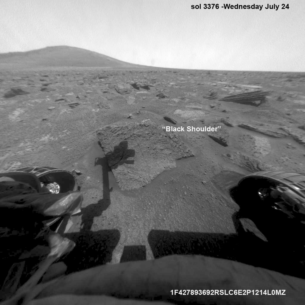
“We slowed down this week so that we could check out the rocks here where there is a strange hydration signature from orbital remote sensing,” says Crumpler.
“This is also an area that appears to have more large blocks in the HiRISE images [from Mars orbit], so we are checking out one of the blocks, “Black Shoulder”.
“We are hoping that the rocks on the ridge crest will be spectacular too,” notes Crumpler.
Opportunity rover’s view very near the foothills of Solander Point along the rim and vast expanse of Endeavour Crater. This area exhibits gypsum signatures and numerous blocks of intriguing rock. Solander Point is the 1st Martian Mountain NASA’s Opportunity will climb and the rovers next destination. Solander Point may harbor clay minerals indicative of a past Martian habitable environment. This navcam panoramic mosaic was assembled from raw images taken on Sol 3374 (July 21, 2013). Credit: NASA/JPL/Cornell/Marco Di Lorenzo/Ken Kremer (kenkremer.com)
Opportunity is using the science instruments on her 3 foot ( 1 meter) long robotic arm to conduct brief in-situ investigations of “Black Shoulder” with the Microscopic Imager (MI) and the Alpha Particle X-ray Spectrometer (APXS).
And …. it’s ‘Mountains Galore’ from here on out for the remainder of Opportunity’s Magnificent Mission to Mars.
Why? Because Opportunity is nearing the foothills of a long chain of eroded segments of the crater wall of Endeavour crater which spans a humongous 14 miles (22 kilometers) wide.
Solander Point may harbor deposits of phyllosilicate clay minerals – which form in neutral pH water – in a thick layer of rock stacks indicative of a past Martian habitable zone.
The rover team is discussing the best way to approach and drive up Solander.
“One idea is to drive part way up Solander from the west side of the rim, turn left and then drive down the steeper north facing slopes with the stratographic sections,” Ray Arvidson explained to Universe Today.
“That way we don’t have to drive up the relatively steeper slopes.”
“The rover can drive up rocky surfaces inclined about 12 to 15 degrees.”
“We want to go through the stratographic sections on the north facing sections,” Arvidson told me.
Opportunity rover moves closer to the foothills of Solander Point along the rim and vast expanse of Endeavour Crater. The rover investigated one of the large rocks near here with her microscopic imager and X-Ray spectrometer. Soon she will start climbing up Solander – her 1st Martian Mountain ascent. This navcam panoramic mosaic was assembled from raw images taken on Sol 3376 (July 23, 2013).
Credit: NASA/JPL/Cornell/Marco Di Lorenzo/Ken Kremer (kenkremer.com)
Today (July 28) is Sol 3380 for a mission that was only warrantied to last 90 Sols!
Opportunity’s total driving distance exceeds 23.6 miles (37.9 kilometers). She has snapped over 182,000 images.
The “work volume”. This view from the front hazcams shows the rock target that is being checked out before the final slog to the south. With luck, by the end of next week we will be plinking around the base of yonder mountain. “Plinking” is a geological term for wandering around with your hammer trying to get a handle on the local outcrops before plunging ahead with mapping and asking the rocks serious questions. Credit: NASA/JPL/Larry Crumpler
Meanwhile on the opposite side of Mars at Gale Crater, Opportunity’s younger sister rover Curiosity also discovered a habitable environment originating from a time when the Red Planet was far warmer and wetter billions of years ago.
And like Opportunity, Curiosity is also trekking towards a mountain rich in sedimentary layers hoping to unveil the mysteries of Mars past. But Curiosity likely won’t arrive at 3.4 mile (5.5 km) high Mount Sharp for another year.
Traverse Map for NASA’s Opportunity rover from 2004 to 2013
This map shows the entire path the rover has driven during more than 9 years and over 3374 Sols, or Martian days, since landing inside Eagle Crater on Jan 24, 2004 to current location near foothills of Solander Point at the western rim of Endeavour Crater. Opportunity discovered clay minerals at Esperance – indicative of a habitable zone. Credit: NASA/JPL/Cornell/ASU/Marco Di Lorenzo/Ken Kremer
…………….
Learn more about Mars, Curiosity, Opportunity, LADEE, MAVEN, Antares and more at Ken’s upcoming lecture presentations
Aug 12: “RockSat-X Suborbital Launch, LADEE Lunar & Antares Rocket Launches from Virginia”; Rodeway Inn, Chincoteague, VA, 8 PM
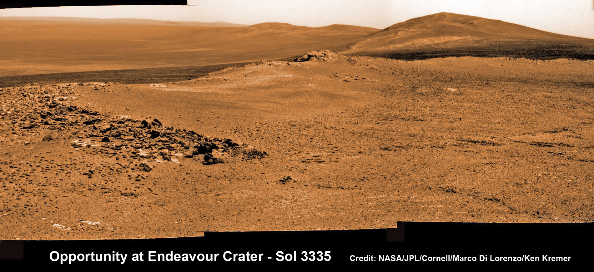
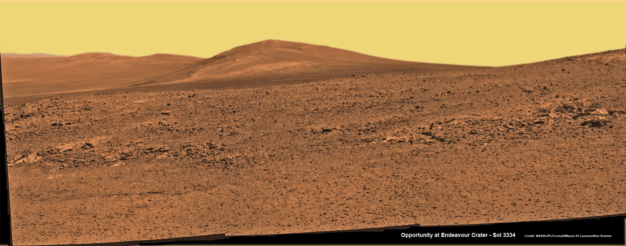
Opportunity rover captures spectacular view ahead to her upcoming mountain climbing goal, the raised rim of “Solander Point” at right, located along the western edge of Endeavour Crater. It may harbor clay minerals indicative of a habitable zone. This pancam photo mosaic was taken on Sol 3335, June 11, 2013. Credit: NASA/JPL/Cornell/ASU/Marco Di Lorenzo/Ken Kremer (kenkremer.com) See full panoramic scene below
Opportunity rover captures spectacular view ahead to her upcoming mountain climbing goal, the raised rim of “Solander Point” at right, located along the western edge of Endeavour Crater. It may harbor clay minerals indicative of a habitable zone. This pancam photo mosaic was taken on Sol 3335, June 11, 2013. Credit: NASA/JPL/Cornell/ASU/Marco Di Lorenzo/Ken Kremer (kenkremer.com)
See full panoramic scene – below Your last chance to “Send Your Name to Mars aboard NASA’s MAVEN orbiter” – below[/caption]
NASA’s nearly decade old Opportunity Mars rover is sailing swiftly on a southerly course towards her first true mountain climbing destination – named “Solander Point” – in search of further evidence of habitable environments with the chemical ingredients necessary to sustain Martian life forms.
At Solander Point, researchers have already spotted deep stacks of ancient rocks transformed by flowing liquid water eons ago. It is located along the western rim of huge Endeavour Crater.
“Right now the rover team is discussing the best way to approach and drive up Solander,” Ray Arvidson told Universe Today. Arvidson is the mission’s deputy principal scientific investigator from Washington University in St. Louis, Mo.
Solander Point may harbor clay minerals in the rock stacks indicative of a past Martian habitable zone.
“One idea is to drive part way up Solander from the west side of the rim, turn left and then drive down the steeper north facing slopes with the stratographic sections,” Arvidson told me.
“That way we don’t have to drive up the relatively steeper slopes. The rover can drive up rocky surfaces inclined about 12 to 15 degrees.”
“We want to go through the stratographic sections on the north facing sections.”
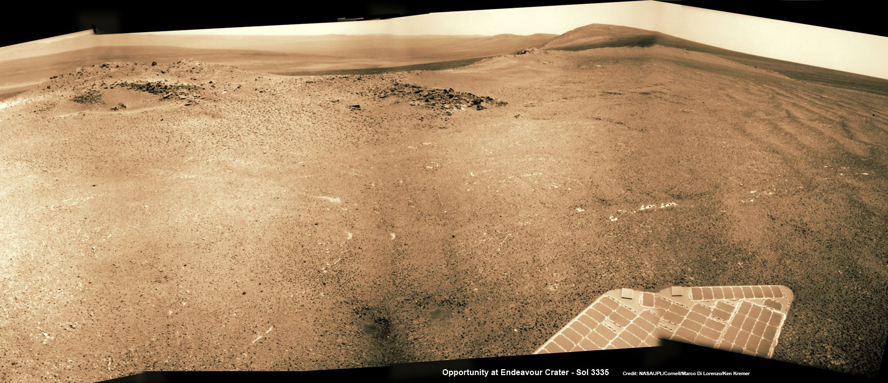
Solander Point mosaic captured by high resolution pancam camera on Sol 3334, June 10, 2013. Opportunity will scale Solander after arriving in August 2013 in search of chemical ingredients to sustain Martian microbes Credit: NASA/JPL/Cornell/ASU/Marco Di Lorenzo/Ken Kremer (kenkremer.com)
The science team hopes that by scaling Solander, Opportunity will build on her recent historic discovery of a habitable environment at a rock called “Esperance” that possesses a cache of phyllosilicate clay minerals.
These aluminum rich clay minerals typically form in neutral, drinkable water that is not extremely acidic or basic and therefore could support a path to potential Martian microbes.
“Esperance ranks as one of my personal Top 5 discoveries of the mission,” said Steve Squyres of Cornell University, Ithaca, N.Y., principal investigator for NASA’s rover mission at a recent media briefing.
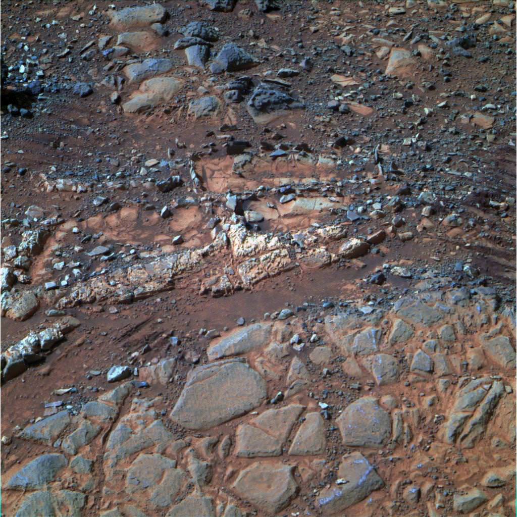
‘Esperance’ Target Examined by Opportunity in May 2013. The pale rock called “Esperance,” has a high concentration of clay minerals formed in near neutral water indcating a spot favorable for life. Credit: NASA/JPL-Caltech/Cornell Univ./Arizona State Univ.
Using high resolution CRISM spectral data collected from Mars orbit, the rover was specifically directed to Esperance, Arvidson explained. The rock was found about a kilometer back on Matijevic Hill at ‘Cape York’, a rather low hilly segment of the western rim of giant Endeavour crater which spans 14 miles (22 km) across.
‘Solander Point’ offers roughly about a 10 times taller stack of geological layering compared to ‘Cape York.’ Both areas are raised segments of the western rim of Endeavour Crater.
The team is working now to obtain the same type of high resolution spectral evidence for phyllosilicate clay minerals at Solander as they had at Cape York to aid in targeting Opportunity to the most promising outcrops, Arvidson explained.
Opportunity is snapping ever more spectacular imagery of Solander Point and the eroded rim of Endeavour Crater as she approaches closer every passing Sol, or Martian Day. See our original photo mosaics herein by Marco Di Lorenzo and Ken Kremer.
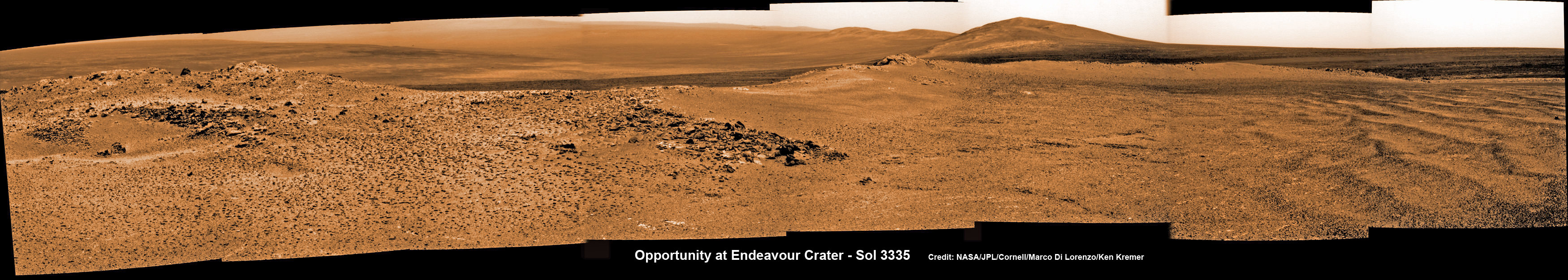
Opportunity captures spectacular panoramic view ahead to her upcoming mountain climbing goal, the raised rim of “Solander Point” at right, located along the western edge of Endeavour Crater. It may harbor clay minerals indicative of a habitable zone. The rise at left is “Nobbys Head” which the rover just passed on its southward drive to Solander Point from Cape York. This pancam photo mosaic was taken on Sol 3335, June 11, 2013 shows vast expanse of the central crater mound and distant Endeavour crater rim.
Credit: NASA/JPL/Cornell/ASU/Marco Di Lorenzo/Ken Kremer (kenkremer.com)
The long lived robot arrived at the edge of Endeavour crater in mid-2011 and will spend her remaining life driving around the scientifically rich crater rim segments.
On June 21, 2013, Opportunity marked five Martian years on Mars since landing on Jan 24, 2004 with a mere 90 day (Sol) ‘warranty’.
This week Opportunity’s total driving distance exceeded 23 miles (37 kilometers).
The solar powered robot remains in excellent health and the life giving solar arrays are producing plenty of electrical power at the moment.
Solander Point also offers northerly tilled slopes that will maximize the power generation during Opportunity’s upcoming 6th Martian winter .
The rover handlers want Opportunity to reach Solander’s slopes by August, before winter’s onset.
As ot today (tosol) Opportunity has trekked about halfway from Cape York to Solander Point – tip to tip.
On the opposite side of Mars at Gale Crater, Opportunity’s younger sister rover Curiosity also discovered clay minerals and a habitable environment originating from a time when the Red Planet was far warmer and wetter billions of years ago.
And this is your last chance to “Send Your Name to Mars” aboard NASA’s MAVEN orbiter- details here. Deadline: July 1, 2013. Launch: Nov. 18, 2013
Wide angle view of Endeavour Crater showing Solander Point and Cape Tribulation in this photo mosaic captured by navcam camera on Sol 3335, June 11, 2013. Opportunity will scale Solander after arriving in August 2013 in search of chemical ingredients to sustain Martian microbes. Credit: NASA/JPL/Cornell/Marco Di Lorenzo/Ken Kremer (kenkremer.com)Traverse Map for NASA’s Opportunity rover from 2004 to 2013. This map shows the entire path the rover has driven during more than 9 years and over 3351 Sols, or Martian days, since landing inside Eagle Crater on Jan 24, 2004 to current location heading south to Solander Point from Cape York ridge at the western rim of Endeavour Crater. Credit: NASA/JPL/Cornell/ASU/Marco Di Lorenzo/Ken Kremer
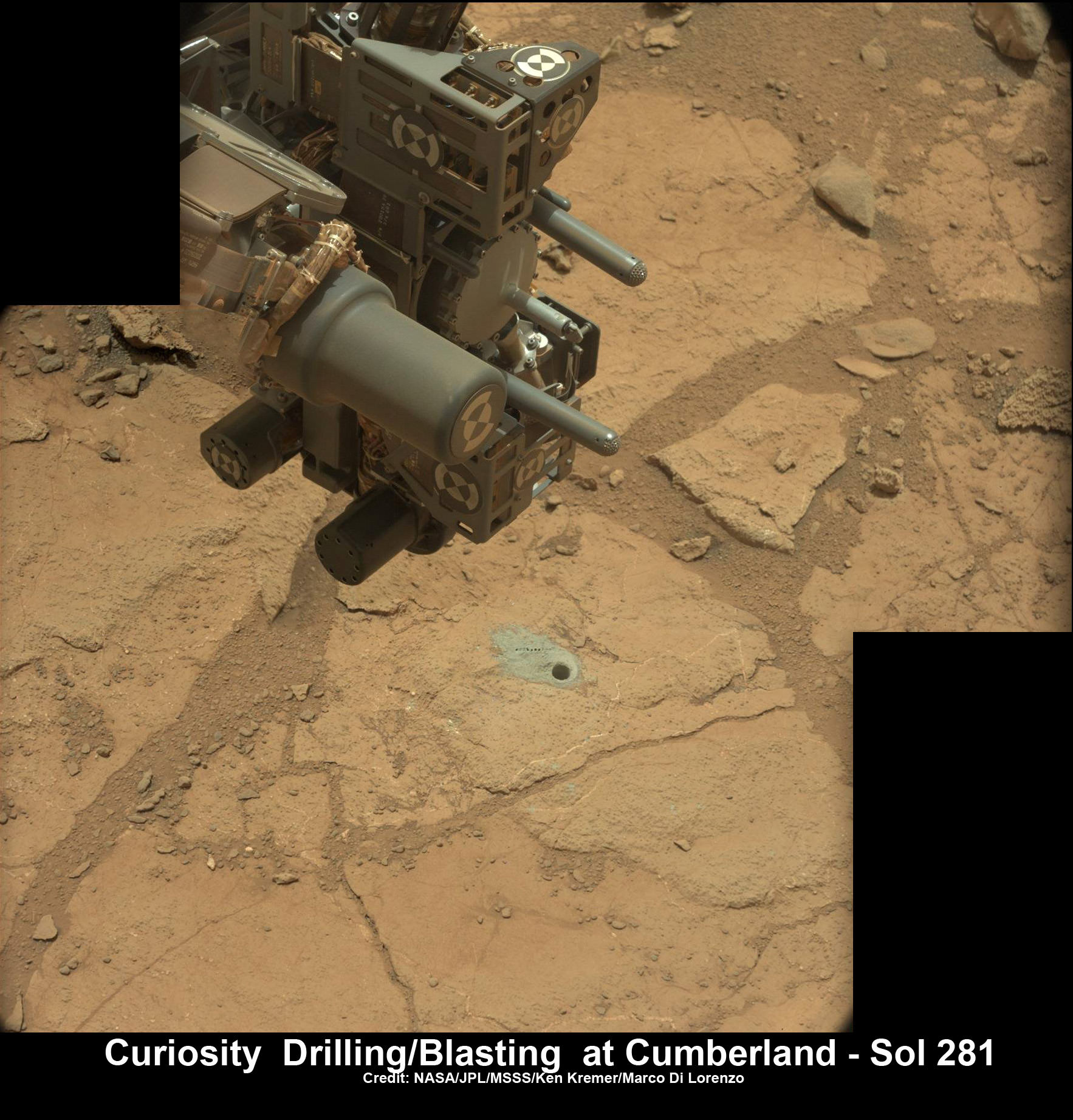
Curiosity’s hi tech ‘hand’ and percussion drill hovers above 2nd bore hole at Cumberland mudstone rock after penetrating laser blasting to unlock secrets of ancient flow of Martian water. Photo mosaic assembled from high resolution Mastcam images on May 21, 2013, Sol 281. Credit: NASA/JPL-Caltech/MSSS/Ken Kremer (kenkremer.com)/Marco Di Lorenzo
Ten months after her breathtaking touchdown on the Red Planet, NASA’s Curiosity rover is nearly set to embark on an epic drive like no other in space history to the slopes of mysterious Mount Sharp – looming supreme inside Gale Crater and the primary mission objective.
But not before the robot completes a few last critical science tasks to more fully illuminate the potential for the origin of Martian microbes in the habitable zone discovered at the work-site of her first penetrations into Mars water altered surface.
The rover science team has chosen a trio of final targets to investigate around the shallow basin of Yellowknife Bay, that resembles a dried out lakebed, where Curiosity has toiled for the past six months, drilled twice into the mudstone outcrops at ‘John Klein’ and ‘Cumberland’ and repeatedly fired her powerful science laser.
Curiosity will revisit a pair of intriguing outcrops named ‘Point Lake’ and ‘Shaler’ that the rover briefly investigated before arriving at ‘John Klein’, said Joy Crisp of JPL, Curiosity’s deputy project scientist, at a media briefing.
“Shaler might be a river deposit. Point Lake might be volcanic or sedimentary. A closer look at them could give us better understanding of how the rocks we sampled with the drill fit into the history of how the environment changed.”
Curiosity will employ nearly all her science instruments to study the outcrops – except the drill.
“It’s highly unlikely to drill at ‘Point Lake’ and ‘Shaler’ because we want to get driving,” Crisp told Universe Today.
“We might drill somewhere along the way to Mount Sharp depending on whether we find something compelling.”
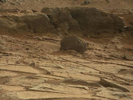
‘Point Lake’ Outcrop in Gale Crater. A priority target for a closer look byCuriosity before the rover departs the “Glenelg” area east of its landing site. The pitted outcrop called “Point Lake” is about 7 feet (2 meters) wide and 20 inches (50 centimeters) high. A closer inspection may yield information about whether it is a volcanic or sedimentary deposit. Credit: NASA/JPL-Caltech/MSSS
Researchers will also use the DAN (Dynamic Albedo of Neutrons) instrument to look for traces of mineral bound water – in the form of hydrogen – at the boundary between bedrock areas of mudstone and sandstone.
Thereafter, Curiosity’s handlers will command the 1 ton behemoth to begin the drive to the lower reaches of Mount Sharp which lies about 6 miles (10 kilometers) distant – as the Martian crow flies.
Mount Sharp rises about 3.4 miles (5.5 km) from the center of Gale Crater. It’s taller than Mount Ranier in Washington State.
Billions of years of Mars geologic history are preserved in the sedimentary layers of Mount Sharp – along with potential signatures of the chemical ingredients of life.
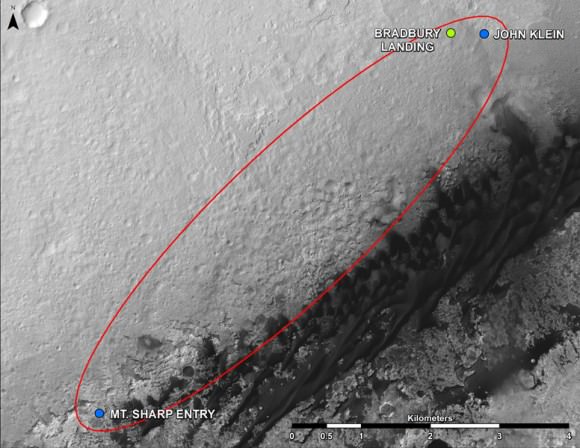
Curiosity Route Map From ‘Glenelg’ to Mount Sharp.
This map shows where NASA’s Mars rover Curiosity landed in August 2012 at “Bradbury Landing”; the area where the rover worked from November 2012 through May 2013 at and near the “John Klein” target rock in the “Glenelg” area; and the mission’s next major destination, the entry point to the base of Mount Sharp. Credit: NASA/JPL-Caltech/Univ. of Arizona
“The drive will start in a few weeks,” said Curiosity Project Manager Jim Erickson of NASA’s Jet Propulsion Laboratory, Pasadena, Calif. at the briefing.
But the team will be on the lookout for targets of opportunity along the way.
“We are on a mission of exploration. If we come across scientifically interesting areas, we are going to stop and examine them before continuing the journey,” Erikson added.
“If we pass something amazing and compelling we might turn around and drive back,” Crisp added.
It could take nearly a year to arrive at Mount Sharp. And Curiosity must pass through a potentially treacherous dune field to get there – see NASA JPL route map above.
“We are looking for the best path though,” said Erickson.
NASA chose Gale as the landing site specifically to dispatch Curiosity to investigate the sedimentary layers of Mount Sharp because it exhibited signatures of clay minerals that form in neutral water and that could possibly support the origin and evolution of simple Martian life forms, past or present.
“We have a real desire to get to Mount Sharp because there we see variations in the mineralogy as we go up from the base to higher levels and a change in the record of the environment,” said Crisp.
Analysis of the initial gray colored, powdery ‘John Klein’ sample by Curiosity’s pair of onboard chemistry labs – SAM & Chemin – revealed that this location on Mars was habitable in the past and possesses the key chemical ingredients – such as clay minerals – required to support microbial life forms- thereby successfully accomplishing the key science objective of the mission and making a historic discovery long before even arriving at destination Mount Sharp.
Besides the science measurements, researchers also learned lot about how to operate the complex drilling and sample delivery mechanisms much more efficiently for the second drilled rock sample.
The sieved and pulverized Cumberland sample was delivered in about a quarter of the time compared to the John Klein sample – accomplished at a deliberately measured and cautious pace.
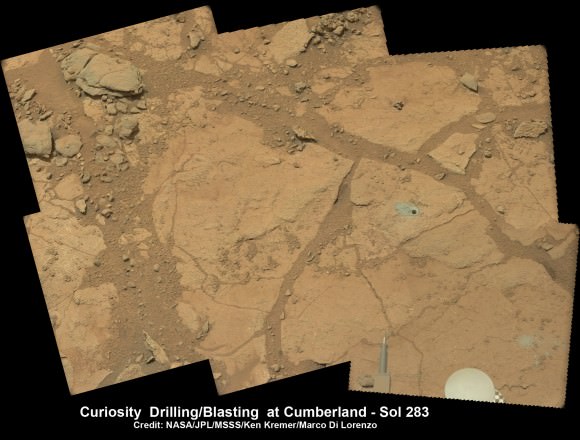
Context view of Curiosity’s 2nd drill site at Cumberland rock on the floor of Yellowknife Bay basin showing ancient water altered rocks where the rover found environmental conditions favorable for microbial life. Mastcam images on May 23, 2013, Sol 283. Credit: NASA/JPL-Caltech/MSSS/Ken Kremer (kenkremer.com)/Marco Di Lorenzo
Analysis of the “Cumberland” powder is currently in progress. The goal is to determine how it compares chemically and to confirm the results found at ‘John Klein.’
“No results from Cumberland are available yet,” said Crisp.
The robot used the powerful million watt ChemCam laser to blast into the Cumberland drill hole and gray tailings scattered on the surface to glean as much insight and measurements of the chemical composition and transformation by water as possible before departing.
Curiosity has just arrived at “Point Lake’. Stay tuned for my next Curiosity story.
Meanwhile, Curiosity’s older sister rover Opportunity has likewise discovered clay minerals and a habitable zone on the opposite side of the Red Planet – details here.
And don’t forget to “Send Your Name to Mars” aboard NASA’s MAVEN orbiter- details here. Deadline: July 1, 2013
Learn more about Mars, Curiosity, Opportunity, MAVEN, LADEE and NASA missions at Ken’s upcoming lecture presentations
June 23: “Send your Name to Mars on MAVEN” and “CIBER Astro Sat, LADEE Lunar & Antares Rocket Launches from Virginia”; Rodeway Inn, Chincoteague, VA, 8 PM
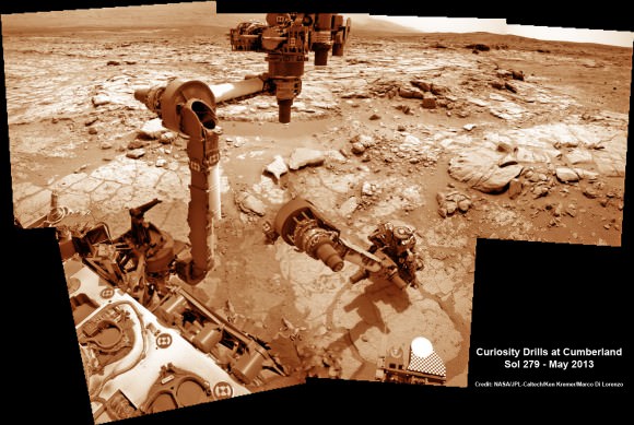
This time lapse mosaic shows Curiosity moving her robotic arm to drill into her 2nd rockt target named “Cumberland” to collect powdery material on May 19, 2013 (Sol 279) for analysis by her onboard chemistry labs; SAM & Chemin. The photomosaic was stitched from raw images captured by the navcam cameras on May 14 & May 19 (Sols 274 & 279). Credit: NASA/JPL-Caltech/Ken Kremer/Marco Di Lorenzo
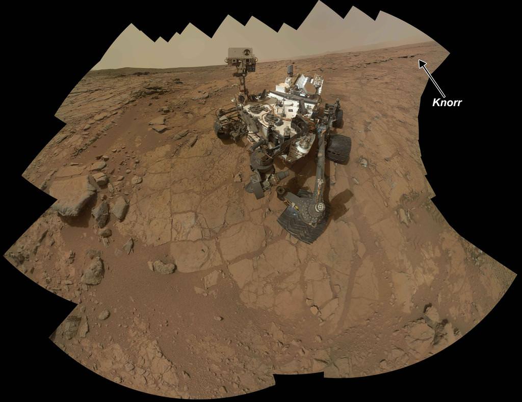
Rock Target ‘Knorr’ Near Curiosity. Scientists used Curiosity's Mast Camera (Mastcam) to study spectral characteristics of the rock target called Knorr in the Yellowknife Bay area and determined that it possessed veins of hydrated minerals, including hydrated calcium sulfate. This self-portrait is a mosaic of images taken by Curiosity's Mars Hand Lens Imager (MAHLI) camera during Sol 177 (Feb. 3, 2013). Credit: NASA/JPL-Caltech/MSSS
The science team guiding NASA’s Curiosity Mars Science Lab (MSL) rover have demonstrated a new capability that significantly enhances the robots capability to scan her surroundings for signs of life giving water – from a distance. And the rover appears to have found that evidence for water at the Gale Crater landing site is also more widespread than prior indications.
The powerful Mastcam cameras peering from the rovers head can now also be used as a mineral-detecting and hydration-detecting tool to search 360 degrees around every spot she explores for the ingredients required for habitability and precursors to life.
Researchers announced the new findings today (March 18) at a news briefing at the Lunar and Planetary Science Conference in The Woodlands, Texas.
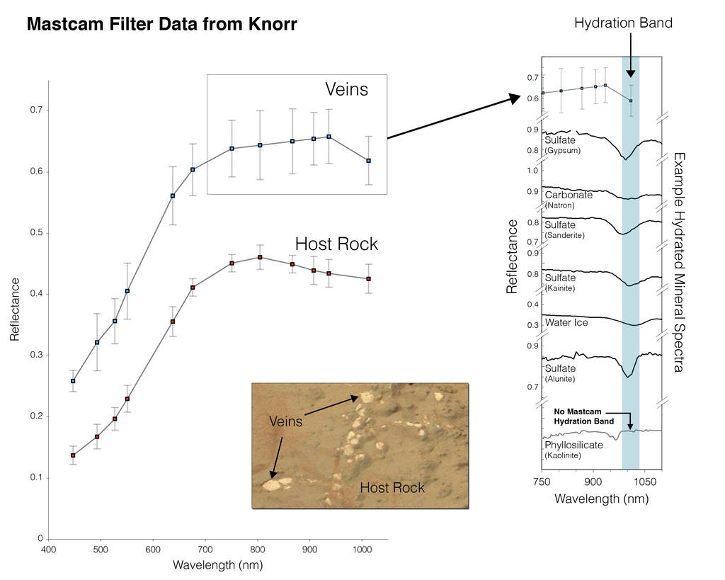
“Some iron-bearing rocks and minerals can be detected and mapped using the Mastcam’s near-infrared filters,” says Prof. Jim Bell, Mastcam co-investigator of Arizona State University, Tempe.
Bell explained that scientists used the filter wheels on the Mastcam cameras to run an experiment by taking measurements in different wavelength’s on a rock target called ‘Knorr’ in the Yellowknife Bay area were Curiosity is now exploring. The rover recently drilled into the John Klein outcrop of mudstone that is crisscrossed with bright veins.
Curiosity accomplished Historic 1st drilling into Martian rock at John Klein outcrop on Feb 8, 2013 (Sol 182), shown in this context mosaic view of the Yellowknife Bay basin taken on Jan. 26 (Sol 169) where the robot is currently working. The robotic arm is pressing down on the surface at John Klein outcrop of veined hydrated minerals – dramatically back dropped with her ultimate destination; Mount Sharp. Credit: NASA/JPL-Caltech/Ken Kremer (kenkremer.com)/Marco Di Lorenzo
Researchers found that near-infrared wavelengths on Mastcam can be used as a new analytical technique to detect the presence of some but not all types of hydrated minerals.
“Mastcam has some capability to search for hydrated minerals,” said Melissa Rice of the California Institute of Technology, Pasadena.
“The first use of the Mastcam 34 mm camera to find water was at the rock target called “Knorr.”
“With Mastcam, we see elevated hydration signals in the narrow veins that cut many of the rocks in this area. These bright veins contain hydrated minerals that are different from the clay minerals in the surrounding rock matrix.”
Mastcam thus serves as an early detective for water without having to drive up to every spot of interest, saving precious time and effort.
Hydration in Veins and Nodules at ‘Knorr’ rock in Yellowknife bay. At different locations on the surface of the same rock, scientists can use the Mast Camera (Mastcam) on Curiosity to measure the amount of reflected light at a series of different wavelengths to obtain spectral information about composition. The inset photograph shows two locations on a rock target called “Knorr,” where Mastcam spectral measurements were made: A light-toned vein and part of the host rock. The main graph shows the spectra recorded at those two points, with increasing wavelengths of visible light and near-infrared light from left to right, and with increasing intensity of reflectance from bottom to top. The bright vein shows greater reflectance through the range of wavelengths assessed. The shapes of the two curves also differ, especially where the vein spectrum dips in the near-infrared wavelengths. The range of wavelengths included in box-outlined portion of the vein spectrum is shown at the top of the group of reference spectra to the right. These reference spectra show how the dip in reflectance at those wavelengths in the vein material corresponds to dips in those wavelengths in several types of hydrated minerals — minerals that have molecules of water bound into their crystalline structure, including hydrated calcium-sulfates. Mastcam is not sensitive to all hydrated minerals, however, including many phyllosilicates. Credit: NASA/JPL-Caltech/MSSS/ASU
But Mastcam has some limits. “It is not sensitive to the hydrated phyllosilicates found in the drilling sample at John Klein” Rice explained.
“Mastcam can use the hydration mapping technique to look for targets related to water that correspond to hydrated minerals,” Rice added. “It’s a bonus in searching for water!”
The key finding of Curiosity thus far is that the fine-grained, sedimentary mudstone rock at the Yellowknife Bay basin possesses a significant amount of phyllosilicate clay minerals; indicating an environment where Martian microbes could once have thrived in the distant past.
“We have found a habitable environment which is so benign and supportive of life that probably if this water was around, and you had been on the planet, you would have been able to drink it,” said John Grotzinger, the chief scientist for the Curiosity Mars Science Laboratory mission at the California Institute of Technology in Pasadena, Calif.
Hydration Map, Based on Mastcam Spectra for ‘Knorr’ rock target shows coded map of the amount of mineral hydration indicated by a ratio of near-infrared reflectance intensities measured by Curiosity. The color scale on the right shows the assignment of colors for relative strength of the calculated signal for hydration. The map shows that the stronger signals for hydration are associated with pale veins and light-toned nodules in the rock. The Mastcam observations were conducted during Sol 133 (Dec. 20, 2012). The width of the area shown in the image is about 10 inches (25 centimeters). Credit: NASA/JPL-Caltech/MSSS/ASU
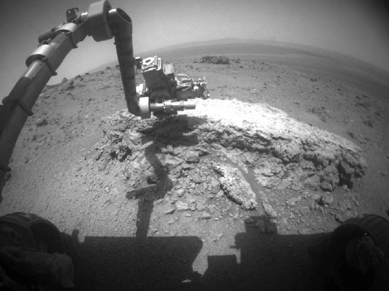
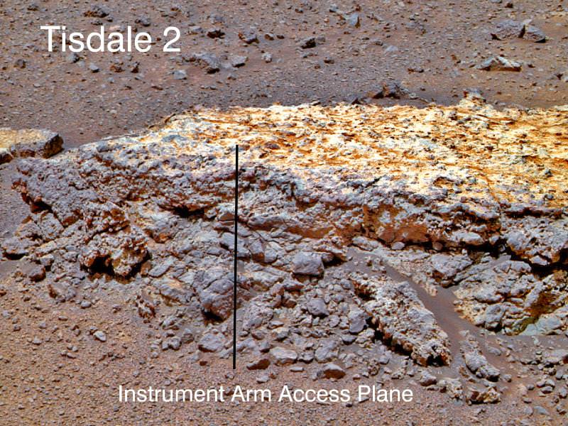
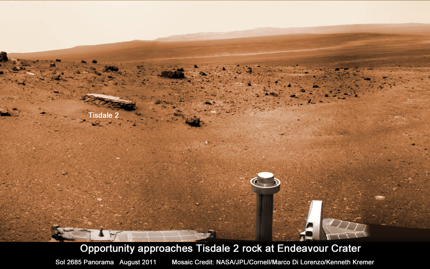
Opportunity investigates Tisdale 2 rock showing indications of ancient Martian water flow. NASA's Mars Exploration Rover Opportunity used its front hazard-avoidance camera to take this picture showing the rover's arm extended toward a light-toned rock, "Tisdale 2," during Sol 2695 of the rover's work on Mars (Aug. 23, 2011). The composition of Tisdale 2 is unlike any rock studied by Opportunity since landing 7.5 years ago. It is about 12 inches (30 centimeters) tall. Credit: NASA/JPL-Caltech
Scientists directing NASA’s Mars Opportunity rover gushed with excitement as they announced that the aging robot has discovered a rock with a composition unlike anything previously explored on the Red Planet’s surface – since she landed on the exotic Martian plains 7.5 years ago – and which offers indications that liquid water might have percolated or flowed at this spot billions of years ago.
Barely three weeks ago Opportunity arrived at the rim of the gigantic 14 mile ( 22 km) wide crater named Endeavour after an epic multi-year trek, and for the team it’s literally been like a 2nd landing on Mars – and the equivalent of the birth of a whole new mission of exploration at an entirely ‘new’ landing site.
“This is like having a brand new landing site for our veteran rover,” said Dave Lavery, program executive for NASA’s Mars Exploration Rovers at NASA Headquarters in Washington. “It is a remarkable bonus that comes from being able to rove on Mars with well-built hardware that lasts.”
Opportunity has traversed an incredible distance of 20.8 miles (33.5 km) across the Meridiani Planum region of Mars since landing on January 24, 2004 for a 3 month mission – now 30 times longer than the original warranty.
“Tisdale 2” is the name of the first rock that Opportunity drove to and investigated after reaching Endeavour crater and climbing up the rim at a low ridge dubbed ‘Cape York’.
This rock, informally named "Tisdale 2," was the first rock the NASA's Mars Rover Opportunity examined in detail on the rim of Endeavour crater. It has textures and composition unlike any rock the rover examined during its first 90 months on Mars. Its characteristics are consistent with the rock being a breccia -- a type of rock fusing together broken fragments of older rocks. Image credit: NASA/JPL-Caltech/Cornell/ASU
Endeavour’s rim is heavily eroded and discontinuous and divided into a series of segmented and beautiful mountainous ridges that offer a bonanza for science.
“This is not like anything we’ve ever seen before. So this is a new kind of rock.” said Steve Squyres, principal investigator for Opportunity at Cornell University in Ithaca, N.Y at a briefing for reporters on Sept. 1.
“It has a composition similar to some volcanic rocks, but there’s much more zinc and bromine than we’ve typically seen. We are getting confirmation that reaching Endeavour really has given us the equivalent of a second landing site for Opportunity.”
Tisdale 2 is a flat-topped rock about the size of a footstool that was blasted free by the impact that formed the tennis court sized “Odyssey” crater from which it was ejected.
“The other big take-away message, and this is to me the most interesting thing about Tisdale, is that this rock has a huge amount of zinc in it, way more zinc than we have ever seen in any Martian rock. And we are puzzling, we are thinking very hard over what that means,” Squyres speculated.
Bright veins cutting across outcrop in a section of Endeavour crater's rim called "Botany Bay" are visible in the foreground and middle distance of this view assembled from images taken by the navigation camera on Opportunity during Sol 2,681on Mars (Aug. 9, 2011). Credit: NASA/JPL-Caltech
Squyres said that high levels of zinc and bromine on Earth are often associated with rocks in contact with flowing water and thus experiencing hydrothermal activity and that the impact is the source of the water.
“When you find rocks on Earth that are rich in zinc, they typically form in a place where you had some kind of hydrothermal activity going on, in other words, you have water that gets heated up and it flows through the rocks and it can dissolve out and it can get redeposited in various places,” Squyres explained.
“So this is a clue, not definitive proof yet, but this is a clue that we may be dealing with a hydrothermal system here, we may be dealing with a situation where water has percolated or flowed or somehow moved through these rocks, maybe as vapor, maybe as liquid, don’t know yet.”
“But it has enhanced the zinc concentration in this rock to levels far in excess of anything we’ve ever seen on Mars before. So that’s the beginning of what we expect is going to be a long and very interesting story about these rocks.”
Endeavour crater was chosen three years ago as the long term destination for Opportunity because it may hold clues to a time billions and billions of years ago when Mars was warmer and wetter and harbored an environment that was far more conducive to the formation of life beyond Earth.
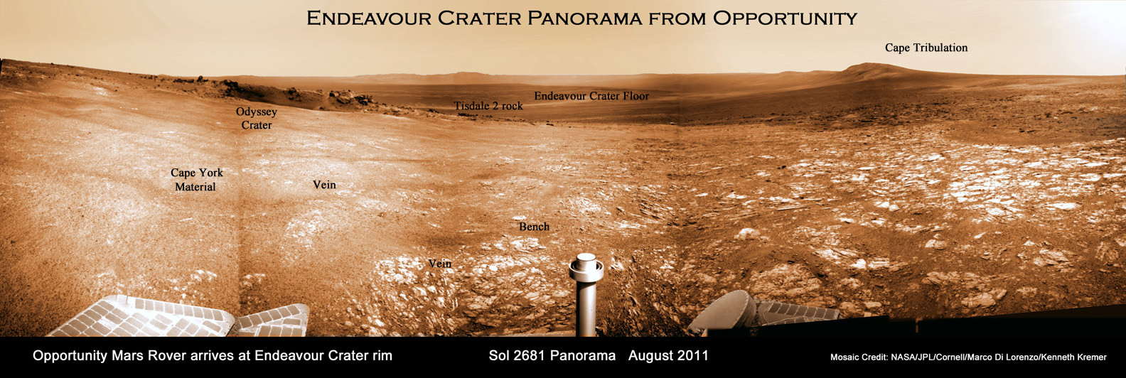
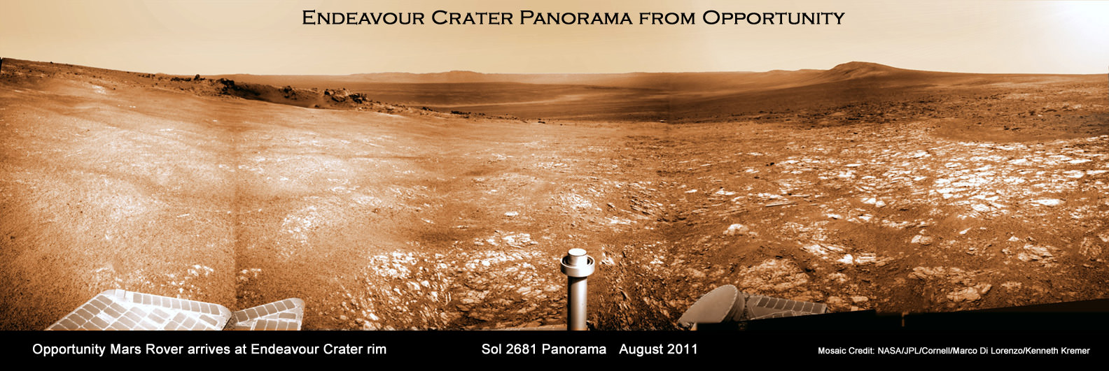
Endeavour Crater Panorama from Opportunity, Sol 2681, August 2011
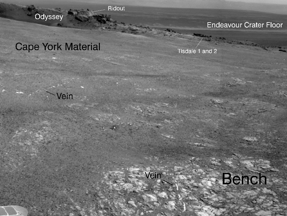
Opportunity arrived at the rim of Endeavour on Sol 2681, August 9, 2011 and climbed up the ridge known as Cape York. Odyssey crater is visible at left. The rover has driven to Tisdale 2 rock at the outskirts of Odyssey to investigate the ejecta blocks which may hold clues to ancient water flow on Mars. Distant portions of Endeavour’s rim - as far as 13 miles away – visible in the background. The rover will likely drive eventually to the Cape Tribulation rim segment at right which holds a mother lode of clay minerals. This photo mosaic was stitched together from raw images taken by Opportunity on Sol 2681.
Mosaic Credit: NASA/JPL/Cornell/Marco Di Lorenzo/Kenneth Kremer
Signatures of clay minerals, or phyllosilicates, were detected at several spots at Endeavour’s western rim by observations from the Compact Reconnaissance Imaging Spectrometer for Mars (CRISM) aboard NASA’s Mars Reconnaissance Orbiter (MRO).
“The motherlode of clay minerals is on Cape Tribulation. The exposure extends all the way to the top, mainly on the inboard side,” said Ray Arvidson, the rover’s deputy principal investigator at Washington University in St. Louis.
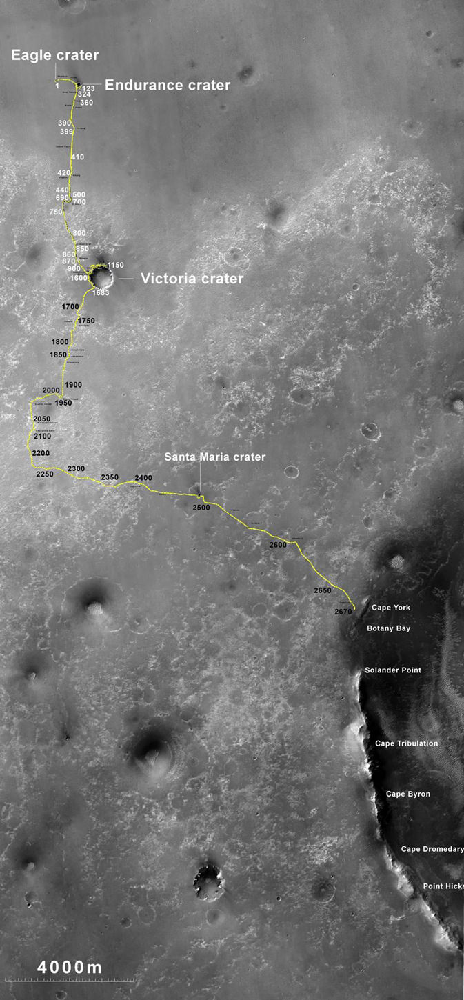
Opportunity Traverse Map: 2004 to 2011. The yellow line on this map shows where NASA's Mars Rover Opportunity has driven from the place where it landed in January 2004 -- inside Eagle crater, at the upper left end of the track -- to a point approaching the rim of Endeavour crater. The map traces the route through the 2,670th Martian day, or sol, of Opportunity's work on Mars (July 29, 2011). Image credit: NASA/JPL-Caltech/MSSS/NMMNHS.
Phyllosilicates are clay minerals that form in the presence of pH neutral water and which are far more hospitable to the possible genesis of life compared to the sulfate rich rocks studied in the more highly acidic aqueous environments examined by both the Opportunity and Spirit rovers thus far.
“We can get up the side of Cape Tribulation,” said Arvidson. It’s not unlike Husband Hill for Spirit. We need to finish up first at Cape York, get through the martian winter and then start working our way south along Solander Point.
The general plan is that Opportunity will probably spend the next several months exploring the Cape York region for before going elsewhere. “Just from Tisdale 2 we know that we have something really new and different here,” said Squyres.
“On the final traverses to Cape York, we saw ragged outcrops at Botany Bay unlike anything Opportunity has seen so far, and a bench around the edge of Cape York looks like sedimentary rock that’s been cut and filled with veins of material possibly delivered by water,” said Arvidson. “We made an explicit decision to examine ancient rocks of Cape York first.”
So far at least the terrain at Cape York looks safe for driving with good prospects for mobility.
Opportunity approaches Tisdale 2 rock at Endeavour Crater rim
Opportunity Mars rover climbed up the ridge known as Cape York and drove to the flat topped Tisdale 2 rock at upper left to analyze it with the science instruments on the robotic arm. This photo mosaic was stitched together from raw images taken by Opportunity on Sol 2685, August 2011.
Mosaic Credit: NASA/JPL/Cornell/Marco Di Lorenzo/Kenneth Kremer
“The good news is that, as predicted, we have hard packed soils like the plains at Gusev that Spirit saw before getting to the Columbia Hills,” said Arvidson. “The wheel tracks at Cape York are very, very shallow. So if anything we will have some skid going downhill the slopes of 5 to 10 degrees on the inboard side which we can correct for.”
“We are always on the lookout for sand traps. We are particularly sensitized to that after the Spirit situation. So far it’s clear sailing ahead.”
Opportunity will then likely head southwards towards an area dubbed “Botany Bay” and eventually drive some 1.5 km further to the next ridge named Cape Tribulation and hopefully scale the slopes in an uphill search for that mother lode of phyllosilicates.
“My strong hope – if the rover lasts that long – is that we will have a vehicle that is capable of climbing Cape Tribulation just as we climbed Husband Hill with Spirit. So it’s obvious to try if the rover is capable, otherwise we would try something simpler. But even if we lose a wheel we still have a vehicle capable of a lot of science,” Squyres emphasized. “Then we would stick to lower ground and more gently sloping stuff.”
“The clear intention as we finish up at Cape York, and look at what to do next, is that we are going to work our way south. We will focus along the crater’s rim. We will work south along the rim of Endeavour unless some discovery unexpectedly causes us to do something else.”
“We will go where the science takes us !” Squyres stated.
Opportunity is in generally good health but the rover is showing signs of aging.
“All in all, we have a very senior rover that’s showing her age, she has some arthritis and some other issues but generally, she’s in good health, she’s sleeping well at night, her cholesterol levels are excellent and so we look forward to productive scientific exploration for the period ahead,” said John Callas, project manager for Opportunity at NASA’s Jet Propulsion Laboratory in Pasadena, Calif.
“This has the potential to be the most revealing destination ever explored by Opportunity,” said Lavery. “This region is substantially different than anything we’ve seen before. We’re looking at this next phase of Opportunity’s exploration as a whole new mission, entering an area that is significantly different in the geologic context than anything we’ve seen with the rovers.”
This image taken from orbit shows the path of the path driven by NASA's Mars Exploration Rover Opportunity in the weeks around the rover's arrival at the rim of Endeavour crater. The sol number (number of Martian days since the rover landed on Mars) are indicated along the route. Sol 2674 corresponds to Aug. 2, 2011; Sol 2688 corresponds to Aug. 16, 2011. Image credit: NASA/JPL-Caltech/University of ArizonaElevated Zinc and Bromine in Tisdale 2 Rock on Endeavour Rim. This graphic presents information gained by examining part of the Martian rock called "Tisdale 2" with the alpha particle X-ray spectrometer on Mars rover Opportunity and comparing the composition measured there with compositions of other targets examined by Opportunity and its rover twin, Spirit. The comparison targets are soil in Gusev crater, examined by Spirit; the relatively fresh basaltic rock Adirondack, examined by Spirit; the stony meteorite Marquette examined by Opportunity; and Gibraltar, an example of sulfate-rich bedrock examined by Opportunity. The target area on Tisdale 2, called "Timmins 1," contains elevated levels of bromine (Br), zinc (Zn), phosphorus (P), sulfur (S) and chlorine (Cl) relative to the non-sulfate-rich comparison rocks, and high levels of zinc and phosphorus relative to Gibraltar. Credit: NASA/JPL-Caltech/Cornell/Max Planck Institute/University of Guelph
2 billion years ago Mars may have featured a frigid ocean. Credit: Taylor Perron/UC Berkeley.
[/caption]
Many planetary scientists suspect that Mars, now cold and very dry, once had a liquid water ocean covering parts of its surface. But this does not necessarily mean that the Red Planet was ever a tropical paradise… a recent paper by a team of astrobiologists suggests that Mars was much more bitter than balmy.
Astrobiologist Alberto Fairyn and colleagues have published a paper in the journal Nature Geoscience suggesting that the marked absence of phyllosilicates in Mars’ northern lowlands is indicative of a cold ocean environment, with perhaps even a boundary of frozen glaciers.
Phyllosilicates are minerals that, on Earth, are found readily in marine sediments and sedimentary rock that was formed in the presence of an ocean environment. These same minerals have also been seen via orbiting spacecraft spectrometers to be present in sediments located in Mars’ equatorial regions, but not in the northern latitudes. Fairyn and his team, intrigued by the disparity between existing models that described Mars as being once warm and wet and the lack of phyllosilicates in the north, used new climatic and geochemical models to deduce that Mars’ northern oceans must have been consistently near freezing, with portions even covered over by ice.
The current presence of moraines in the northern highlands also suggests that glaciers may have surrounded these frigid seas, which may have prevented the transportation of phyllosilicates down to the northern ocean basin. Again, to use our own planet as an analogy, moraines are rocky debris left over from the movement of glaciers. Their existence on Mars strongly suggests a period of early glaciation.
The research by Fairyn et al. contradict – or, more aptly, combine – two leading concepts of early Mars: one, that it was cold and dry and the existence of any liquid water was restricted to the equator for small periods of time; and two, that it was once globally warmer and wetter and sustained rivers, lakes and oceans of liquid water for extended periods.
Thus a cold Mars with an Arctic, icy ocean seems to be a more fitting causation of the current state of the planet, suggests Fairyn.
More research is planned, including running through more low-temperature models and hunting for ancient coastal areas that may have been impacted by icebergs. This will no doubt prove to be a challenge since much of the evidence is now buried deep beneath newer sediments and volcanic deposits. Still, Fairyn is confident that his model may help solve a long-standing debate over the history of the Red Planet.
Jason Major is a graphic designer, photo enthusiast and space blogger. Visit his website Lights in the Dark and follow him on Twitter @JPMajor or on Facebook for the most up-to-date astronomy awesomeness!
Endeavour Crater Panorama from Opportunity, Sol 2681, August 2011. NASA’s Opportunity Mars rover arrived at the rim of huge Endeavour crater on Sol 2681, August 9, 2011 and climbed up the ridge known as Cape York. A small crater dubbed ‘Odyssey’ is visible in the foreground at left. The rover has now driven to the outskirts of Odyssey to investigate the ejecta blocks which may stem from an ancient and wetter Martian Epoch. Opportunity snapped this soaring panorama showing distant portions of Endeavour’s rim - as far as 13 miles away - in the background. This photo mosaic was stitched together from raw images taken by Opportunity on Sol 2681. Mosaic Credit: NASA/JPL/Cornell/Marco Di Lorenzo/Kenneth Kremer
[/caption]NASA’s Mars Opportunity rover has finally arrived at the huge Martian crater named Endeavour that simultaneously offers a mother lode of superb scenery and potentially the “Mother of all Martian Science”. The epic journey took nearly three years.
The intrepid robogirl is now climbing uphill on a Scientific quest that may well produce bountiful results towards the most important findings ever related to the search for life on Mars. Opportunity arrived at the western rim of the 13 mile (21 km) wide Endeavour crater on the 2681st Sol , or Martian day, of a mission only warrantied to last 90 Sols.
See our new Opportunity panoramic mosaics (Marco Di Lorenzo & Ken Kremer) illustrating the magnificent scenery and science targets now at hand on the surface of the Red Planet, thanks to the diligent work of the science and engineering teams who created the twin Mars Exploration Rover (MER) vehicles – Spirit & Opportunity.
Opportunity made landfall at Endeavour at a ridge of the discontinuous crater rim named Cape York and at a spot dubbed “Spirit Point” – in honor or her twin sister Spirit which stopped communicating with Earth about a year ago following more than six years of active science duty. See traverse map mosaic.
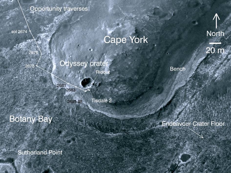
The martian robot quickly started driving northwards up the gnetle slopes of Cape York and has reached a small crater named “Odyssey” – the first science target, Dr. Matt Golembek told Universe Today. Golembek is a Senior Research Scientist with the Mars Exploration Program at the Jet Propulsion Laboratory (JPL) in Pasadena, Calif.
“Large ejecta blocks are clearly visible on the rim of Odyssey crater,” said Golembek. The crater is about 66 feet (20 m) in diameter.
Odyssey is a small impact crater of interest to the team because it features exposed material from Mars ancient Noachian era that was ejected when the crater was excavated long ago. Opportunity carefully drove over several days to one of those ejecta blocks – a flat topped rock nicknamed Tisdale 2.
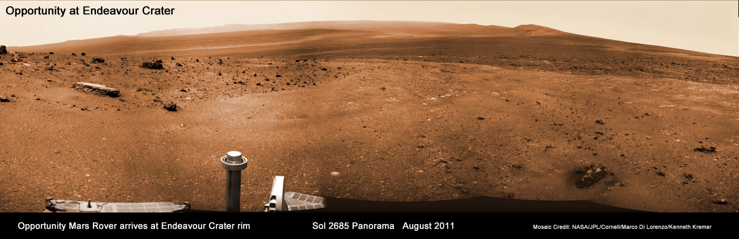
Endeavour Crater Panorama from Opportunity, Sol 2685, August 2011
NASA’s Opportunity Mars rover arrived at the rim of huge Endeavour crater on Sol 2681, August 9, 2011 and is climbed up the ridge known as Cape York. She drove to the flat topped Tisdale 2 rock at upper left to analyze it with the science instruments on the robotic arm. Opportunity snapped this soaring panorama showing distant portions of Endeavour’s rim - as far as 13 miles away - in the background. This photo mosaic was stitched together from raw images taken by Opportunity on Sol 2685.
Mosaic Credit: NASA/JPL/Cornell/Marco Di Lorenzo/Kenneth Kremer
“Opportunity is at a block of Odyssey crater ejecta called Tisdale 2 and the rock appears different from anything else we have seen,” Golembek explained.
Starting on Sol 2688 (Aug. 16) the rover began a science campaign time to investigate the rock with the instruments at the terminus of its robotic arm or IDD (Instrument Deployment Device) that will continue for some period of time.
“We are about to start an IDD campaign,” Golembek stated.
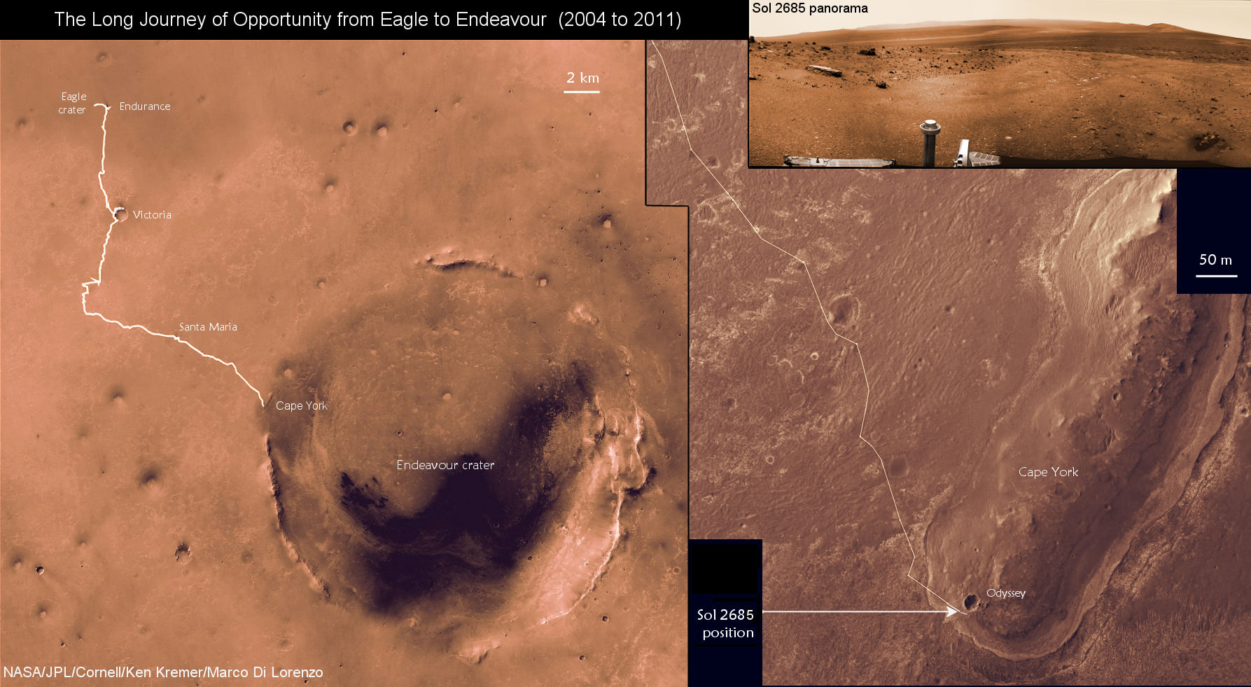
The Long Journey of Opportunity form Eagle to Endeavour Crater (2004 to 2011).
This map mosaic shows Opportunity’s epic trek of nearly eight years from landing at Eagle crater on January 24, 2004 to arrival at the giant 13 mile (21 km) diameter Endeavour crater in August 2011. Opportunity arrived the Endeavour’s rim and then drove up a ridge named Cape York. The photomosaic at top right show the outlook from Cape York on Sol 2685 (August 2011).
Mosaic Credit: NASA/JPL/Cornell/Kenneth Kremer/Marco Di Lorenzo
The team reports that the soil at Cape York is also of a different texture than any that Opportunity has seen so far on her incredible 20 mile (33 km) trek across the Meridiani Planum region of Mars. So far they haven’t seen of the iron-rich concretions, nicknamed “blueberries,” which have been plentiful on the surface along the way at numerous locations Opportunity has stopped at and investigated over the past 90 months. Initially the prime mission was projected to last 3 months – the remainder has been a huge bonus.
The science team is directing Opportunity to hunt for clay minerals, also known as phyllosilicates, that could unlock the secrets of an ancient Epoch on Mars stretching back billions and billions of years ago that was far wetter and very likely more habitable and welcoming to life’s genesis.
Phyllosilicate minerals form in neutral water that would be vastly more friendly to any potential Martian life forms – if they ever existed in the past or present. Signatures for phyllosilicates were detected by the CRISM instrument aboard NASA’s powerful Mars Reconnaissance Orbiter (MRO) spacecraft circling Mars
Flat-topped Tisdale 2 rock. Credit: NASA/JPL-Caltech'Ridout' Rock on Rim of Odyssey Crater. Opportunity looked across small Odyssey crater on the rim of much larger Endeavour crater to capture this raw image from its panoramic camera during the rover's 2,685th Martian day, or sol, of work on Mars (Aug. 13, 2011). From a position south of Odyssey, this view is dominated by a rock informally named "Ridout" on the northeastern rim of Odyssey. The rock is roughly the same size as the rover, which is 4.9 feet (1.5 meters) long. Credit: NASA/JPL-Caltech/Cornell/ASU