In 250 Million Years, a Single Supercontinent will Form, Wiping Out Nearly all Mammals

Figure 1 from the study displaying the warmest month average temperature (degrees Celsius) for Earth and the hypothesized supercontinent, Pangea Ultima, 250 million years from now, which the researchers hypothesize would make life for most mammals extremely difficult. (Credit: University of Bristol)

A recent study published in Nature Geoscience uses supercomputer climate models to examine how a supercontinent, dubbed Pangea Ultima (also called Pangea Proxima), that will form 250 million years from now will result in extreme temperatures, making this new supercontinent uninhabitable for life, specifically mammals. This study was conducted by an international team of researchers led by the University of Bristol and holds the potential to help scientists better understand how Earth’s climate could change in the distant future from natural processes, as opposed to climate change.

Continue reading “In 250 Million Years, a Single Supercontinent will Form, Wiping Out Nearly all Mammals”

What Is Pangaea?

Continents might be necessary for life, especially complex life. This image shows super-continent Pangaea during the Permian period (300 - 250 million years ago). Credit: NAU Geology/Ron Blakey

So, you are curious about what is Pangaea? It was the supercontinent that existed 250 million years ago during the Paleozoic and Mesozoic eras. During the ensuing millenia, plate tectonics slowly moved each continent to its current position on the planet. Each continent is still slowly moving across the face of our world.

The breaking up and formation of supercontinents appears to have happened several times over Earth’s history with Pangaea being one among many. The next-to-last one, Pannotia, formed about 600 million years ago during the Proterozoic eon. Pannotia included large amounts of land near the poles and only a relatively small strip near the equator connecting the polar masses.

60 million years after its formation Pannotia broke up, giving rise to the continents of Laurentia, Baltica, and Gondwana. Laurentia would eventually become a large portion of North America, the microcontinent of Avalonia(a small portion of Gondwana) would become the northeastern United States, Nova Scotia, and England. All of these came together at the end of the Ordovician.

While this was happening, Gondwana drifted slowly towards the South Pole. These were the early steps in the formation of Pangaea. The next step was the collision of Gondwana with the other land mass. Southern Europe broke free of Gondwana. By late Silurian time, North and South China rifted away from Gondwana and started to head northward across the shrinking Proto-Tethys Ocean.

Movement continued slowly until the land masses drifted until their current positions. The list of oceans and microcontinents is too long to include in this article. We have many articles about this full process here on Universe Today. The evidence for Pangaea lies in the fossil records from the period. It includes the presence of similar and identical species on continents that are now great distances apart.

Additional evidence for Pangaea is found in the geology of adjacent continents, including matching geological trends between the eastern coast of South America and western Africa. The polar ice cap of the Carboniferous Period covered the southern end of Pangaea. Glacial deposits of the same age and structure are found on many separate continents which would have been together in the continent of Pangaea.

We know that the existence of supercontinents has been proven. We know that they have existed at different times in the Earth’s history. Also, we know that the tectonic plates are still moving. Is it possible that there will be another supercontinent someday in the distant future.

We have written many articles about Pangaea for Universe Today. Here’s an article about the Continental Drift Theory, and here’s an article about the continental plates.

If you’d like more info on Pangaea, check out the Pangaea Interactive Map Game. And here’s a link to NASA’s Continents in Collision: Pangaea Ultima.

We’ve also recorded an episode of Astronomy Cast all about Plate Tectonics. Listen here, Episode 142: Plate Tectonics.

Sources:
http://en.wikipedia.org/wiki/Pangaea
http://pubs.usgs.gov/gip/dynamic/historical.html
http://library.thinkquest.org/17701/high/pangaea/

Continental Drift Theory

Map showing some of the continents

In elementary school, every teacher had one of those pull-down maps of the world to teach geography. On occasion, I thought the largest land masses, known as continents, reminded me of pieces in a jigsaw puzzle. They just seemed like they should fit together, somehow. Not until I took Earth Science, in 8TH grade, did I discover my earlier idea was correct. My teacher explained about a phenomenon, known as, The Continental Drift Theory. He said that some German had the same idea I did.

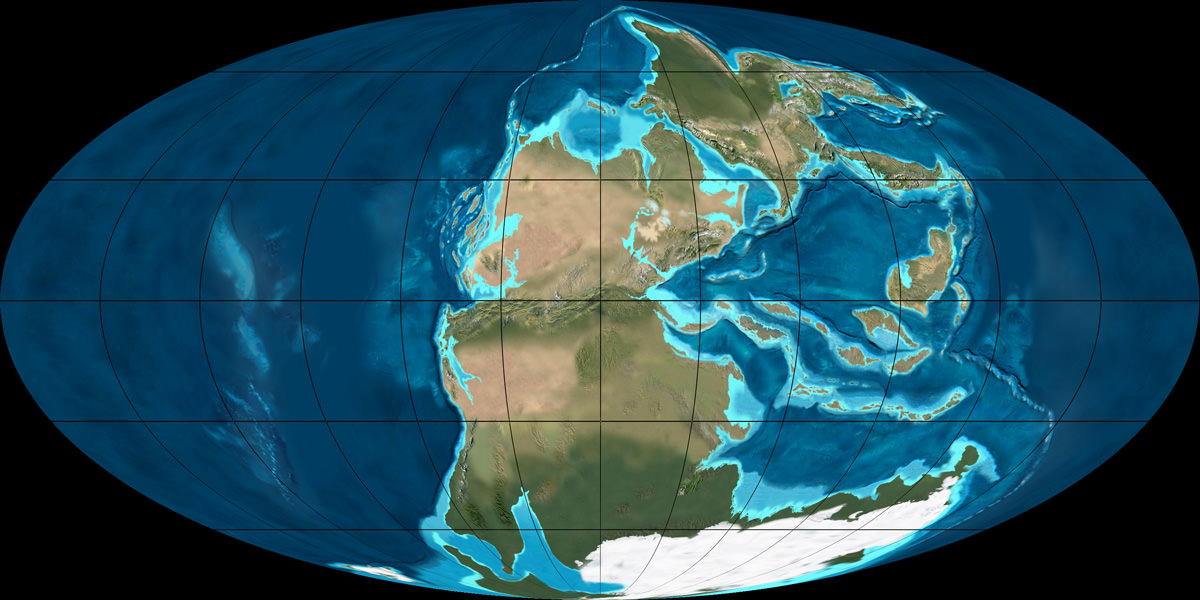
The man my teacher mentioned, Alfred Wegener (Vay gen ner), developed The Continental Drift Theory in 1915. He was a meteorolgist and a geologist. His theory basically said that, at one time, there existed one large supercontinent, called, Pangea, pan, meaning all-encompassing, and, gea, meaning the Earth. He went on to suggest that, seismic activity, such as erthquakes, volcanic eruptions, and tsunamis, also called tidal waves, eventually created fissures, or cracks in the Earth. As these fissures became larger, longer, and deeper, 7 pieces of Pangea broke off and, over time, drifted to the places where they are now. These 7 large pieces of land are what we now call, continents. They are: North America; South America; Europe; Asia; Africa; Antarctica; and, Australia. Some people refer to the country as Australia, and the continent as, Oceania. They do this because there are other countries, such as New Zealand, included as a part of that particular continent.

At the time, people thought Wegener was, well, “nuts.” Only in the 1950s did people begin to take his idea seriously. According to the United States Geological Survey (the USGS), thanks to the use of the submarine and the technology developed during World War II, scientists learned a lot about the Ocean Floor. When they found out that it was not as old as the Crust, or Surface, of the Earth, sicentists had to ask themselves, “Why?”

The answers have to do with earthquakes, volcanoes, and magnetism. When the Earth cracks, molten magma, from the middle of the Earth, known as the Mantle, works its way to the surface, where it becomes known as, lava. That lava melts away some of the older layers; then, when the water cools that lava, it forms a new layer of Earth. For that reason, if scientists tried to determine the age of the Earth from samples taken from the Ocean Floor, they would be very wrong.

That same equipment also helped scientists recognize that heavy amounts of basalt, a volcanic rock that contains high amounts of iron, could throw compasses off course. This information provided one more pieces to the puzzle. Now, scientists recognize that the North and South Poles were not always where they currently are.

The Earth changes every day. Although we might not notice it, the continents move all the time. We don’t only revolve, or spin, around the Sun. We also drift across the surface of the planet.

The United States Geological Survey has some excellent information on this topic.

University Today has some other fabulous material about this and related topics, including Earth, Barely Habitable?, by Fraser Cain begin_of_the_skype_highlighting     end_of_the_skype_highlighting, and Interesting Facts About Planet Earth.

You can also read or listen to Episode 51: Earth, of Astronomy Cast, also produced by Universe Today.

Sources:
http://en.wikipedia.org/wiki/Continental_drift
http://www.ucmp.berkeley.edu/history/wegener.html
http://pubs.usgs.gov/gip/dynamic/historical.html