A relic of the early Space Age turns 44 years old this week.
The United Kingdom’s first and only successful space launch using a UK-built rocket is still visible in low Earth orbit today, if you know exact where and how to look for it.
Launched atop a 3-stage Black Arrow R3 rocket on October 28th, 1971 from the Woomera launch station in the Australian outback, Prospero (sometimes also referred to simply as the X-3) was designed to test key communications satellite technologies.
Prospero wasn’t the first satellite fielded by the United Kingdom–that credit goes to the Ariel 1 satellite launched atop a Thor DM-19 Delta rocket by the United States from Cape Canaveral on April 26th, 1962—but Prospero was notable as part of a program cut short in its early stages.
The Black Arrow project from which Prospero was born was cancelled shortly after the launch, making the X-3 the only successful mission fielded by the program (X-2 failed to achieve orbit due to an early shut-down of the stage 2 rocket). Prospero almost didn’t make it as well, as the final Waxwing stage hit the satellite upon deployment, taking one of Prospero’s four radio antennae clean off!
How to spot fainter satellites
Unlike watching for bright passes of naked eye objects in low Earth orbit such as the International Space Station, hunting for binocular satellites such as Prospero takes careful planning. Our tried and true technique is not unlike the method recently described on Universe Today to hunt for near Earth grazers such as the Halloween asteroid 2015 TB 145. In stakeout mode, you’ll need to know exactly when Prospero passes near a bright object, such as a star or planet.
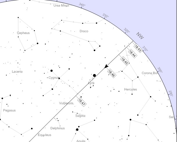
Heavens-Above is a great resource, and catalogs every satellite back through the early Space Age. And what’s really nifty is that Heavens-Above will plot the passage of the satellite showing the timing of the pass against the sky against the background of constellations and stars for your specific location.
A screen capture of a satellite pass from Heavens-Above. Image credit: Chris Peat/Heavens Above.com
If you have Space-Track access, you can also download the TLEs (Two Line Elements) for a particular satellite for manual entry into a program such as Starry Night or Orbitron to forecast passes. You’ll be aiming your binoculars at the target star Project Moonwatch-style at the appointed time, and simply waiting for the satellite to drift by. For precise timing, we like to listen to WWV radio broadcasting the time (in Universal or Greenwich Mean/Zulu Time) out of Fort Collins Colorado on AM shortwave 5000, 10000, 15000 and 20000 Hz. WWV radio calls out the time at the top of each minute, with time ticks for each second, allowing the observer to keep eyes on the sky continuously. Just which WWV station comes in clearest can vary after sunset, as the ionosphere changes in terms of radio reflectivity at dusk.
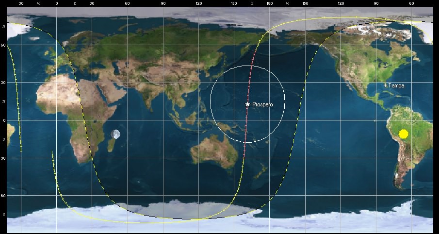
The orbital trace of Prospero. Image Credit: Orbitron
We tracked down a good pass on the errant ‘space tool bag’ lost by International Space Station astros back in 2008 using this method once it was assigned an individual NORAD ID number… there it was, a lost tool satchel with a date with a fiery reentry destiny, drifting right by the bright star Spica at the appointed time.
Prospects for Prospero
Radio operators tracked Prospero for decades on transmission frequency 137.560 MHz until 2004, eight years past its official deactivation in 1996. As of this writing, there aren’t any official future attempts to contact Prospero in the works, though it’s certainly possible for a motivated party to do in theory… Prospero isn’t expected to reenter until 2070, and perhaps it’ll last until its centenary in space.
For latitudes 30-40 degrees north, good viewing prospects for Prospero start up again around December 20th of this year at dusk. At its brightest on a pass straight overhead through the observer’s zenith, expect Prospero to reach about +8 magnitude in brightness, well within range of binoculars. Prospero orbits Earth once every 103 minutes in a 527 by 1,304 kilometre orbit, inclined 82 degrees relative to the Earth’s equator. Prospero’s NORAD ID COSPAR designator is 1971-093A catalog number (05580).
Our favorite tool for satellite hunting… Image credit: Dave Dickinson
Other relics of the Space Age are also visible in backyard near you, including:
The Vanguards: launched in starting in 1958 by the United States, The three Vanguard satellites represent the oldest bits of human artifacts in Earth orbit, and they aren’t due for reentry for another two centuries.
Tracking relics of the Space Age brings home the personal relevance of early space history. Looking further out towards satellites in geostationary orbit, we are seeing artifacts that may long withstand the tests of time and become the solitary testaments of our current civilization to a far off future era.
-Got a favorite relic of the Space Age you’d like us to track down? Let us know!
A 10 second exposure of a bright pass of the International Space Station. (Photo by Author).
It’s a question we get all the time.
Watch the sky closely in the dawn or dusk hours, and you’ll likely see a moving “star” or two sliding by. These are satellites, or “artificial moons” placed in low Earth orbit. These shine via reflected sunlight as they pass hundreds of kilometres overhead.
Many folks are unaware that you can see satellites with the naked eye. I always make an effort to watch for these during public star parties and point them out. A bright pass of the International Space Station if often as memorable as anything that can be seen through the eyepiece. But after this revelation, “the question” soon follows- “What satellite is that?”
Welcome to the wonderful and highly addictive world of satellite tracking. Ground observers have been watching the skies since Sputnik 1 and the first satellite launch in October 1957. Armies of dedicated volunteers even participated in tracking the early launches of the Space Age with Operation Moonwatch.
Depiction of the apparent motion of a typical satellite overhead with respect to the observer. (Graphic created by author).
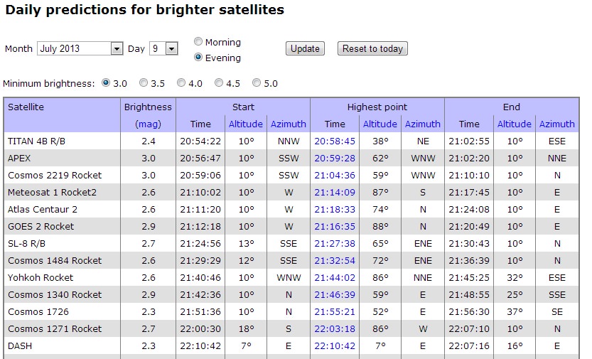
The Internet has offered a wealth of information for satellite hunters. Every time I write about “how to spot the ISS,” someone amazes me with yet another new tracker App that I hadn’t heard of. One of my favorites is still Heavens-Above. It’s strange to think that we’ve been visiting this outstanding website daily for a decade and a half now. Heavens-Above specializes in satellites, and will show you a quick listing of passes for brighter satellites once configured with your location. A nifty “quick check” for possibly resolving a mystery satellite is their link for “Daily Predictions for brighter satellites” Which will generate a list of visible passes by time.
Screenshot of a typical list of bright satellite passes from Heavens-Above filtered by brightness, time and location .
Looking at the time, direction, and brightness of a pass is crucial to satellite identification. No equipment is needed to start the hunt for satellites tonight, just a working set of eyes and information. We sometimes use a set of Canon image-stabilized 15x 45 binoculars to hunt for satellites too faint to see with the naked eye. We’ve seen the “Tool Bag” lost during an ISS EVA a few years back, as well as such “living relics” of the early Space Age as Canada’s first satellite Alloutte-1, and the Vanguards (Yes, they’re STILL up there!) using binocs.
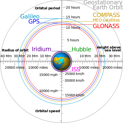
A comparison of typical satellite orbits. (Credit: Cmglee, Geo Swan graphic under a Creative Commons Attribution -Share Alike 3.0 unported license).
The trick to catching fainter satellites such as these is to “ambush” them. You’ll need to note the precise time that the selected satellite is going to pass near a bright star. Clicking on a selected satellite pass in Heavens-Above will give you a local sky chart with a time-marked path. I use a short wave portable AM radio tuned to WWV out of Fort Collins, Colorado for an accurate audible time signal. Just sit back, listen to the radio call out the time, and watch for the satellite to pass through the field of view near the target star.
Another great site for more advanced trackers is CALSky. Like Heavens-Above, CALSky will give you a customized list for satellite passes over your location. One cool extra feature on CALSky is the ability to set alerts for passes of the ISS near bright planets or transiting the Sun or Moon. These are difficult events to capture, but worth it!
The International Space Station transiting the Moon as captured by Mike Weasner from Cassiopeia Observatory in Arizona.
A great deal of what’s up there is space junk in the form of discarded hardware. Many satellites are on looping elliptical orbits, only visible to the naked eye when they are near perigee. Many satellites are located out at geosynchronous or geostationary orbits 35,786 kilometres distant and are invisible to the naked eye all together. These will often show up as streaks in astrophotos. An area notorious for geosynchronous satellites exists near the direction of M42 or Orion Nebula. During certain times of year, satellites can be seen nearby, nodding slowly north to south and back again. Around the March and September equinox seasons, geostationary satellites can be eclipsed by the shadow of the Earth. This can also cause communications difficulties, as many geo-sats also lie sunward as seen from the Earth around these times of year.
Probably one of the simplest satellite trackers for casual users is Space Weather’s Satellite Flybys page. North American users simply need to enter a postal code (worldwide users can track satellites via entering “country-state-city”) and a list of passes for your location is generated.
It’s a basic truism of satellite tracking that “aircraft blink; satellites don’t”. Know, we’re going to present an exception to this rule.
Some satellites will flash rhythmically due to a tumbling motion. This can be pretty dramatic to see. What you’re seeing is an expended booster, a cylinder tumbling due to atmospheric drag end-over-end. Some satellites can flash or flare briefly due to sunlight glinting off of reflective surfaces just right. Hubble, the ISS and the late NanoSail D2 can flare if conditions are just right.
The most dramatic of these are Iridium flares. The Iridium constellation consists of 66 active satellites used for satellite phone coverage in low-Earth orbit. When one of their three refrigerator-sized antennas catch the Sun just right, they can flare up to magnitude -8, or 40 times brighter than Venus. CALSky and Heavens-Above will also predict these events for your location.
Didn’t see a predicted satellite pass? Light pollution or bright twilight skies might be to blame. Keep in mind, passes lower to the horizon also fall prey to atmospheric extinction, as you’re looking through a thicker layer of the air than straight overhead. Some satellites such as the ISS or the USAF’s X-37B spy space plane even periodically boost or modify their orbits, throwing online prediction platforms off for a time.
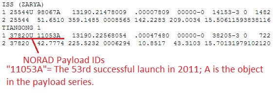
A screenshot example of TLE’s for the ISS & Tiangong-1 from Celestrak.
I use a free tracking platform created by Sebastian Stoff known as Orbitron. Orbitron lets you set your observing location and tailor your view for what’s currently over head. You can run simulations and even filter for “visual only” passes, another plus. I also like Orbitron’s ability to run as a stand-alone system in the field, sans Internet connection. Just remember, for it to work properly, you’ll need to periodically update the .txt file containing the Two-Line Element (TLE) sets. TLE’s are data element sets that describe the orbital elements of a satellite. Cut and paste TLEs are available from Heavens-Above and Celestrak.
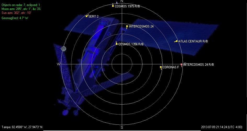
Orbitron screenshot for visible satellites using ‘radar’ mode… there’s lots up there! (Credit: Orbitron).
For serious users, NORAD’s Space-Track is the best site for up-to-date TLEs. Space-Track requires a login and user agreement to access, but is available to satellite spotters and educators as a valuable resource. Space-Track also hosts a table of upcoming reentries, as does the Aerospace Corporation’s Center for Orbital & Reentry Debris Studies.
The SeeSat-L mailing list is also an excellent source of discussion among satellite trackers worldwide. Increasingly, this discussion is also moving over to Twitter, which is ideal for following swiftly evolving action in orbit. @Twisst, created by Jaap Meijers,will even Tweet you prior to an ISS pass!
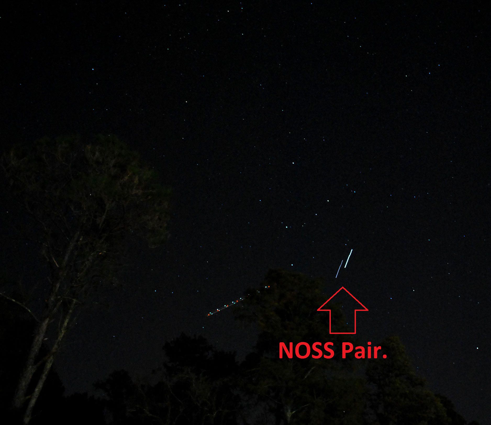
And there’s always something new or strange in the sky for the observant. Satellites such as those used in the Naval Ocean Surveillance System (NOSS) were launched in groups, and are eerie to watch as they move in formations of 2 or 3 across the sky. These are difficult to catch, and all three of our sightings thus far of a NOSS pair have been surreptitious. And we’ve only had the camera ready to swing into action once to nab a NOSS pair;
A NOSS pair captured by the author. The multi-colored trail to the left of the path is an aircraft. Note a bit of “jitter” at the beginning of the exposure- I had to swing the camera into action quickly!
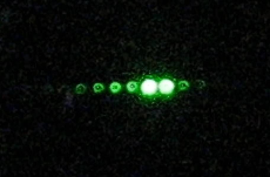
Another bizarre satellite to catch in action is known as the Cloud-Aerosol LiDAR & Infrared Pathfinder Satellite for Observations, or CALIPSO. Part of the “afternoon A-Train” of sun-synchronous Earth observing satellites, you can catch the green LiDAR flashes of CALIPSO from the ground with careful planning, just as Gregg Hendry did in 2008-2009:
A CALIPSO LiDAR pass imaged by Gregg Hendry in 2008. My Hendry mentions that, “The hollow nature of the spots is likely due to some spherical aberration in the camera lens coupled with imperfect focus, and is not representative of the laser beam’s optical quality.” (Credit: Gregg Hendry, used with permission).
NASA even publishes a prediction table for CALIPSO lidar passes. I wonder how many UFO sightings CALIPSO has generated?
Artist’s depiction of the A-Train constellation of Earth-Observing satellites. (Credit: NASA).
And speaking of photography, it’s easy to catch a bright pass such as the ISS on camera. Shooting a satellite pass with a wide field is similar to shooting star trails; just leave the shutter open for 10-60 seconds with a tripod mounted camera. Modern DSLRs allow you to do several test exposures prior to the pass, to get the ISO, f/stop, and shutter speed calibrated to local sky conditions.
You can even image the ISS through a telescope. Several sophisticated rigs exist to accurately track and image the space station through a scope, or you could use our decidedly low-tech but effective hand-guided method;
And that’s a brief overview of the exciting world of sat-spotting… let us know of your tales of triumph and tragedy as you sleuth out what’s going on overhead!