Artist's conception of NASA's Mars Reconnaissance Orbiter. Credit: NASA/JPL
Imagine being able to watch three months’ worth of high-definition space video sequentially — maybe real-time coverage on the International Space Station, or getting to watch the Mars Reconnaissance Orbiter zoom across the Red Planet over and over again. Well, that’s how much science data MRO itself has sent back in 10 years of operations, NASA said.
“The sheer volume is impressive, but of course what’s most important is what we are learning about our neighboring planet,” stated the Jet Propulsion Laboratory’s Rich Zurek, the project scientist for the Mars Reconnaissance Orbiter.
MRO has sent back 200 terabits, all told. It’s a wealth of science data on its own merits as it examined evidence of water, ancient volcanoes and other parts of the Red Planet’s history from above. The spacecraft, however, also serves as a relay for the NASA Curiosity and Opportunity rovers on the surface.
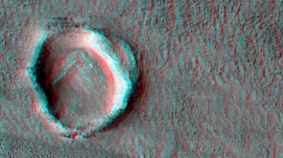
A crater imaged by the Mars Reconnaissance Orbiter’s HiRISE (High Resolution Imaging Science Experiment). Credit: NASA/JPL/University of Arizona
“Data gathered by the orbiter’s instruments and relayed from rovers are recorded onto the orbiter’s central memory. Each orbit around Mars takes the spacecraft about two hours. For part of each orbit, Mars itself usually blocks the communication path to Earth,” NASA stated.
“When Earth is in view, a Deep Space Network antenna on whichever part of Earth is turned toward Mars at that hour can be listening. Complex preparations coordinate scheduling the use of the network’s antennas by all deep-space missions — 32 of them this month. Mars Reconnaissance Orbiter typically gets several sessions every day.”
Once the Deep Space Network antennas in Spain, California and Australia pick up the data, JPL organizes them into their separate “products”, ranging from radar measurements from above to data picked up by a rover below. The information is then sent to various organizations around the world that have interests in the work.
MRO arrived at Mars in 2006 and its mission has been extended three times, with the latest one taking place in 2012. NASA also relays information from the planet using Mars Odyssey, which has been there since 2002.
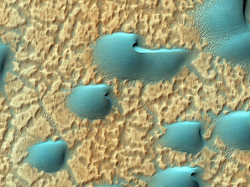
Dunes in Noachis Terra on Mars. Credit: NASA/JPL/University of Arizona
Who doesn’t love Mars? Amid the bad news of a U.S. government shutdown now stretching towards Day 12, there are still several spacecraft from NASA and the European Space Agency taking pictures of that red dot in the sky. Here are some recent stunners from the Red Planet.
Above is an infrared view of Noachis Terra as seen through the eyes of the Mars Reconnaissance Orbiter. The High Resolution Imaging Science Experiment (HiRISE) camera website (from the University of Arizona) released the picture on its website Oct. 2, with this description (in part):
“When there are perfect conditions for producing sand dunes — steady wind in one direction and just enough sand — barchan sand dunes form. The word ‘barchan’ is a Russian term because this type of dune was first described in the desert regions of Turkistan.”
MRO is run under a contract from NASA and is still operating, although its Twitter feed warns funds are running low.
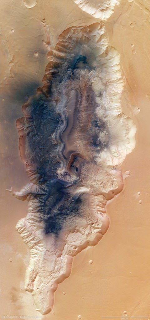
Mosaic of Hebes Chasma by ESA’s Mars Express. Credit: ESA/DLR/FU Berlin (G. Neukum)
Mars Express is a European Space Agency spacecraft and is thus not affected by the shutdown. This mosaic of eight images released Oct. 8 (above) shows Hebes Chasma, which is about 186 miles (300 kilometers) north of Valles Marineris. The trench is about five miles (eight kilometers) deep at its utmost, and hundreds of miles long. “A flat-topped mesa is located in the center of Hebes Chasma, which was likely shaped by the action of wind and water,” ESA wrote.
Meanwhile, the Curiosity and Opportunity rovers are still trundling away on Mars. NASA’s Jet Propulsion Laboratory is a contract operation and is still running its missions for the time being. These pictures were downloaded from the raw image sites for the rovers (here and here) as all press updates are suspended amid the shutdown.
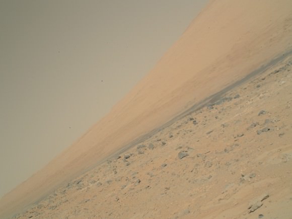
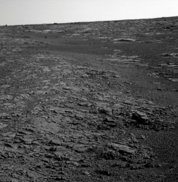
Raw Mars Curiosity image on Oct. 3 of Mount Sharp (Aeolis Mons) using its Mars Hand Lens Imager (MAHLI). Credit: NASA/JPL-Caltech/MSSSRaw image of Opportunity’s view of the Martian horizon on Sol 3450 earlier in October. Credit: NASA/JPL-Caltech
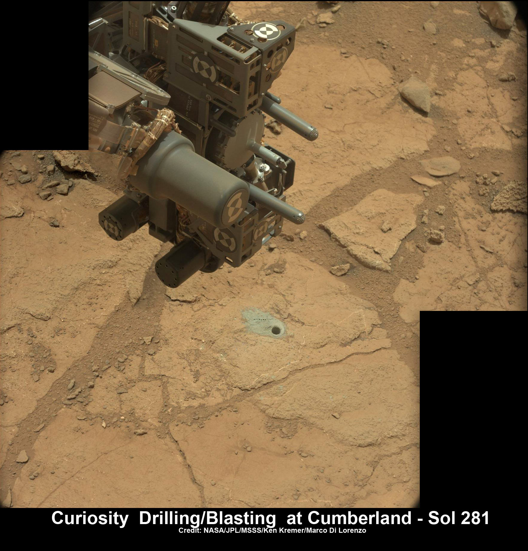
Curiosity’s hi tech ‘hand’ and percussion drill hovers above 2nd bore hole at Cumberland mudstone rock after penetrating laser blasting to unlock secrets of ancient flow of Martian water. Photo mosaic assembled from high resolution Mastcam images on May 21, 2013, Sol 281. Credit: NASA/JPL-Caltech/MSSS/Ken Kremer (kenkremer.com)/Marco Di Lorenzo
Ten months after her breathtaking touchdown on the Red Planet, NASA’s Curiosity rover is nearly set to embark on an epic drive like no other in space history to the slopes of mysterious Mount Sharp – looming supreme inside Gale Crater and the primary mission objective.
But not before the robot completes a few last critical science tasks to more fully illuminate the potential for the origin of Martian microbes in the habitable zone discovered at the work-site of her first penetrations into Mars water altered surface.
The rover science team has chosen a trio of final targets to investigate around the shallow basin of Yellowknife Bay, that resembles a dried out lakebed, where Curiosity has toiled for the past six months, drilled twice into the mudstone outcrops at ‘John Klein’ and ‘Cumberland’ and repeatedly fired her powerful science laser.
Curiosity will revisit a pair of intriguing outcrops named ‘Point Lake’ and ‘Shaler’ that the rover briefly investigated before arriving at ‘John Klein’, said Joy Crisp of JPL, Curiosity’s deputy project scientist, at a media briefing.
“Shaler might be a river deposit. Point Lake might be volcanic or sedimentary. A closer look at them could give us better understanding of how the rocks we sampled with the drill fit into the history of how the environment changed.”
Curiosity will employ nearly all her science instruments to study the outcrops – except the drill.
“It’s highly unlikely to drill at ‘Point Lake’ and ‘Shaler’ because we want to get driving,” Crisp told Universe Today.
“We might drill somewhere along the way to Mount Sharp depending on whether we find something compelling.”
‘Point Lake’ Outcrop in Gale Crater. A priority target for a closer look byCuriosity before the rover departs the “Glenelg” area east of its landing site. The pitted outcrop called “Point Lake” is about 7 feet (2 meters) wide and 20 inches (50 centimeters) high. A closer inspection may yield information about whether it is a volcanic or sedimentary deposit. Credit: NASA/JPL-Caltech/MSSS
Researchers will also use the DAN (Dynamic Albedo of Neutrons) instrument to look for traces of mineral bound water – in the form of hydrogen – at the boundary between bedrock areas of mudstone and sandstone.
Thereafter, Curiosity’s handlers will command the 1 ton behemoth to begin the drive to the lower reaches of Mount Sharp which lies about 6 miles (10 kilometers) distant – as the Martian crow flies.
Mount Sharp rises about 3.4 miles (5.5 km) from the center of Gale Crater. It’s taller than Mount Ranier in Washington State.
Billions of years of Mars geologic history are preserved in the sedimentary layers of Mount Sharp – along with potential signatures of the chemical ingredients of life.
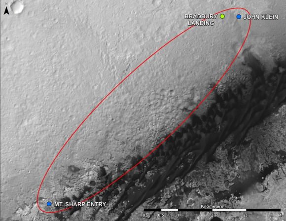
Curiosity Route Map From ‘Glenelg’ to Mount Sharp.
This map shows where NASA’s Mars rover Curiosity landed in August 2012 at “Bradbury Landing”; the area where the rover worked from November 2012 through May 2013 at and near the “John Klein” target rock in the “Glenelg” area; and the mission’s next major destination, the entry point to the base of Mount Sharp. Credit: NASA/JPL-Caltech/Univ. of Arizona
“The drive will start in a few weeks,” said Curiosity Project Manager Jim Erickson of NASA’s Jet Propulsion Laboratory, Pasadena, Calif. at the briefing.
But the team will be on the lookout for targets of opportunity along the way.
“We are on a mission of exploration. If we come across scientifically interesting areas, we are going to stop and examine them before continuing the journey,” Erikson added.
“If we pass something amazing and compelling we might turn around and drive back,” Crisp added.
It could take nearly a year to arrive at Mount Sharp. And Curiosity must pass through a potentially treacherous dune field to get there – see NASA JPL route map above.
“We are looking for the best path though,” said Erickson.
NASA chose Gale as the landing site specifically to dispatch Curiosity to investigate the sedimentary layers of Mount Sharp because it exhibited signatures of clay minerals that form in neutral water and that could possibly support the origin and evolution of simple Martian life forms, past or present.
“We have a real desire to get to Mount Sharp because there we see variations in the mineralogy as we go up from the base to higher levels and a change in the record of the environment,” said Crisp.
Analysis of the initial gray colored, powdery ‘John Klein’ sample by Curiosity’s pair of onboard chemistry labs – SAM & Chemin – revealed that this location on Mars was habitable in the past and possesses the key chemical ingredients – such as clay minerals – required to support microbial life forms- thereby successfully accomplishing the key science objective of the mission and making a historic discovery long before even arriving at destination Mount Sharp.
Besides the science measurements, researchers also learned lot about how to operate the complex drilling and sample delivery mechanisms much more efficiently for the second drilled rock sample.
The sieved and pulverized Cumberland sample was delivered in about a quarter of the time compared to the John Klein sample – accomplished at a deliberately measured and cautious pace.
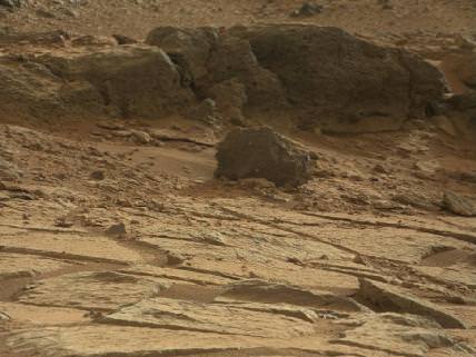
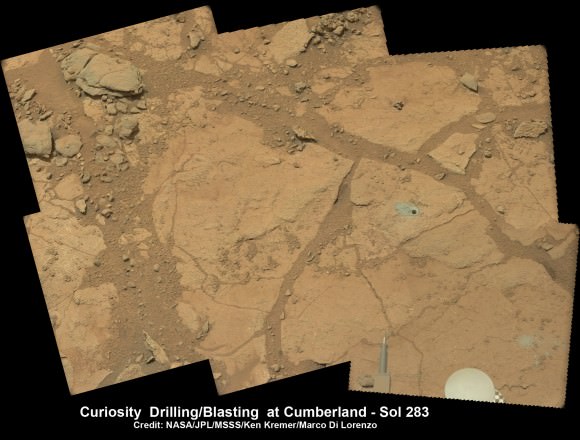
Context view of Curiosity’s 2nd drill site at Cumberland rock on the floor of Yellowknife Bay basin showing ancient water altered rocks where the rover found environmental conditions favorable for microbial life. Mastcam images on May 23, 2013, Sol 283. Credit: NASA/JPL-Caltech/MSSS/Ken Kremer (kenkremer.com)/Marco Di Lorenzo
Analysis of the “Cumberland” powder is currently in progress. The goal is to determine how it compares chemically and to confirm the results found at ‘John Klein.’
“No results from Cumberland are available yet,” said Crisp.
The robot used the powerful million watt ChemCam laser to blast into the Cumberland drill hole and gray tailings scattered on the surface to glean as much insight and measurements of the chemical composition and transformation by water as possible before departing.
Curiosity has just arrived at “Point Lake’. Stay tuned for my next Curiosity story.
Meanwhile, Curiosity’s older sister rover Opportunity has likewise discovered clay minerals and a habitable zone on the opposite side of the Red Planet – details here.
And don’t forget to “Send Your Name to Mars” aboard NASA’s MAVEN orbiter- details here. Deadline: July 1, 2013
Learn more about Mars, Curiosity, Opportunity, MAVEN, LADEE and NASA missions at Ken’s upcoming lecture presentations
June 23: “Send your Name to Mars on MAVEN” and “CIBER Astro Sat, LADEE Lunar & Antares Rocket Launches from Virginia”; Rodeway Inn, Chincoteague, VA, 8 PM
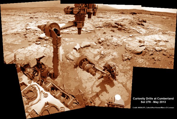
This time lapse mosaic shows Curiosity moving her robotic arm to drill into her 2nd rockt target named “Cumberland” to collect powdery material on May 19, 2013 (Sol 279) for analysis by her onboard chemistry labs; SAM & Chemin. The photomosaic was stitched from raw images captured by the navcam cameras on May 14 & May 19 (Sols 274 & 279). Credit: NASA/JPL-Caltech/Ken Kremer/Marco Di Lorenzo
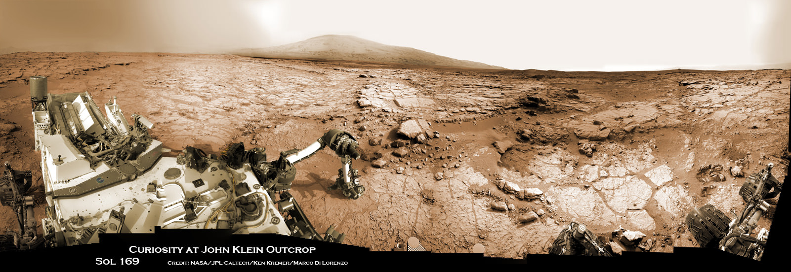
Curiosity accomplished historic 1st drilling into Martian rock at John Klein outcrop on Feb 8, 2013 (Sol 182), shown in this context mosaic view of the Yellowknife Bay basin taken on Jan. 26 (Sol 169) - back dropped with Mount Sharp - where the robot is currently working. Curiosity will bore a 2nd drill hole soon following the resumption of contact with the end of the solar conjunction period. Credit: NASA/JPL-Caltech/Ken Kremer/Marco Di Lorenzo
Curiosity accomplished historic 1st drilling into Martian rock at John Klein outcrop on Feb 8, 2013 (Sol 182), shown in this context mosaic view of the Yellowknife Bay basin taken on Jan. 26 (Sol 169) – back dropped with Mount Sharp – where the robot is currently working. Curiosity will bore a 2nd drill hole soon following the resumption of contact with the end of the solar conjunction period. Credit: NASA/JPL-Caltech/Ken Kremer/Marco Di Lorenzo
See drill hole and conjunction videos below[/caption]
After taking a well deserved and unavoidable break during April’s solar conjunction with Mars that blocked two way communication with Earth, NASA’s powerful Martian fleet of orbiters and rovers have reestablished contact and are alive and well and ready to Rock ‘n Roll ‘n Drill.
“Both orbiters and both rovers are in good health after conjunction,” said NASA JPL spokesman Guy Webster exclusively to Universe Today.
Curiosity’s Chief Scientist John Grotzinger confirmed to me today (May 1) that further drilling around the site of the initial John Klein outcrop bore hole is a top near term priority.
The goal is to search for the chemical ingredients of life.
“We’ll drill a second sample,” Grotzinger told Universe Today exclusively. Grotzinger, of the California Institute of Technology in Pasadena, Calif., leads NASA’s Curiosity Mars Science Laboratory mission.
“We’ll move a small bit, either with the arm or the wheels, and then drill another hole to confirm what we found in the John Klein hole.”
Earth, Mars and the Sun have been lined up in nearly a straight line for the past several weeks, which effectively blocked virtually all contact with NASA’s four pronged investigative Armada at the Red Planet.
NASA’s Red Planet fleet consists of the Curiosity (MSL) and Opportunity (MER) surface rovers as well as the long lived Mars Odyssey (MO) and Mars Reconnaissance Orbiter (MRO) robotic orbiters circling overhead. ESA’s Mars Express orbiter is also exploring the Red Planet.
“All have been in communications,” Webster told me today, May 1.
The NASA spacecraft are functioning normally and beginning to transmit the science data collected and stored in on board memory during the conjunction period when a commanding moratorium was in effect.
“Lots of data that had been stored on MRO during conjunction has been downlinked,” Webster confirmed to Universe Today.
Curiosity and Mount Sharp: Curiosity’s elevated robotic arm and drill stare back at you at the John Klein drill site – back dropped by mysterious Mount Sharp. The rover has resumed contact with NASA following the end of solar conjunction. This panoramic vista was snapped on March 23, 2013, Sol 223. Credit: NASA/JPL-Caltech/Marco Di Lorenzo/KenKremer (kenkremer.com)
And NASA is already transmitting and issuing new marching orders to the Martian Armada to resume their investigations into unveiling the mysteries of the Red Planet and determine whether life ever existed eons ago or today.
“New commanding, post-conjunction has been sent to both orbiters and Opportunity.”
“And the sequence is being developed today for sending to Curiosity tonight (May 1), as scheduled more than a month ago,” Webster explained.
“We’ll spend the next few sols transitioning over to new flight software that gives the rover additional capabilities,” said Grotzinger.
“After that we’ll spend some time testing out the science instruments on the B-side rover compute element – that we booted to before conjunction.”
Curiosity is at work inside the Yellowknife Bay basin just south of the Martian equator. Opportunity is exploring the rim of Endeavour crater at the Cape York rim segment.
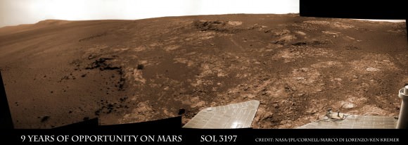
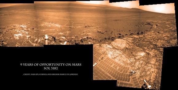
Opportunity Celebrates 9 Years and 3200 Sols on Mars snapping this panoramic view from her current location on ‘Matijevic Hill’ at Endeavour Crater. The rover discovered phyllosilicate clay minerals and calcium sulfate veins at the bright outcrops of ‘Whitewater Lake’, at right, imaged by the Navcam camera on Sol 3197 (Jan. 20, 2013). “Copper Cliff” is the dark outcrop, at top center. Darker “Kirkwood” outcrop, at left, is site of mysterious “newberries” concretions. Credit: NASA/JPL-Caltech/Cornell/Marco Di Lorenzo/Ken Kremer
Mars Solar Conjunction is a normal celestial event that occurs naturally about every 26 months. The science and engineering teams take painstaking preparatory efforts to insure no harm comes to the spacecraft during the conjunction period when they have no chance to assess or intervene in case problems arise.
So it’s great news and a huge relief to the large science and operations teams handling NASA’s Martian assets to learn that all is well.
Since the sun can disrupt and garble communications, mission controllers suspended transmissions and commands so as not to inadvertently create serious problems that could damage the fleet in a worst case scenario.
So what’s on tap for Curiosity and Opportunity in the near term ?
“For the first few days for Curiosity we will be installing a software upgrade.”
“For both rovers, the science teams will be making decisions about how much more to do at current locations before moving on,” Webster told me.
The Opportunity science team has said that the long lived robot has pretty much finished investigating the Cape York area at Endeavour crater where she made the fantastic discovery of phyllosilicates clay minerals that form in neutral water.
Signals from Opportunity received a few days ago on April 27 indicated that the robot had briefly entered a standby auto mode while collecting imagery of the sun.
NASA reported today that all operations with Opportunity was “back under ground control, executing a sequence of commands sent by the rover team”, had returned to normal and the robot exited the precautionary status.
Opportunity Celebrates 9 Years on Mars snapping this panoramic view of the vast expanse of 14 mile (22 km) wide Endeavour Crater from atop ‘Matijevic Hill’ on Sol 3182 (Jan. 5, 2013). The rover then drove 43 feet to arrive at ‘Whitewater Lake’ and investigate clay minerals. Photo mosaic was stitched from Navcam images and colorized. Credit: NASA/JPL-Caltech/Cornell/Ken Kremer/Marco Di Lorenzo
“The Curiosity team has said they want to do at least one more drilling in Yellowknife Bay area,” according to Webster.
Curiosity has already accomplished her primary task and discovered a habitable zone that possesses the key ingredients needed for potential alien microbes to once have thrived in the distant past on the Red Planet when it was warmer and wetter.
The robot found widespread evidence for repeated episodes of flowing liquid water, hydrated mineral veins and phyllosilicates clay minerals on the floor of her Gale Crater landing site after analyzing the first powder ever drilled from a Martian rock.
Video Caption: Historic 1st bore hole drilled by NASA’s Curiosity Mars rover on Sol 182 of the mission (8 Feb 2013). Credit: NASA/JPL-Caltech/MSSS/Marco Di Lorenzo/Ken Kremer (http://www.kenkremer.com/)
During conjunction Curiosity collected weather, radiation and water measurements but no imagery.
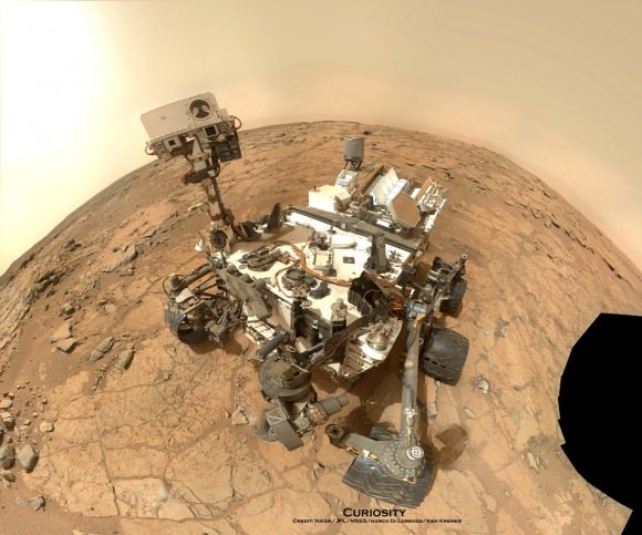
Curiosity Rover snapped this self portrait mosaic with the MAHLI camera while sitting on flat sedimentary rocks at the “John Klein” outcrop where the robot conducted historic first sample drilling inside the Yellowknife Bay basin, on Feb. 8 (Sol 182) at lower left in front of rover. The photo mosaic was stitched from raw images snapped on Sol 177, or Feb 3, 2013, by the robotic arm camera – accounting for foreground camera distortion. Credit: NASA/JPL-Caltech/MSSS/Marco Di Lorenzo/KenKremer (kenkremer.com).
Watch this brief NASA JPL video for an explanation of Mars Solar Conjunction.
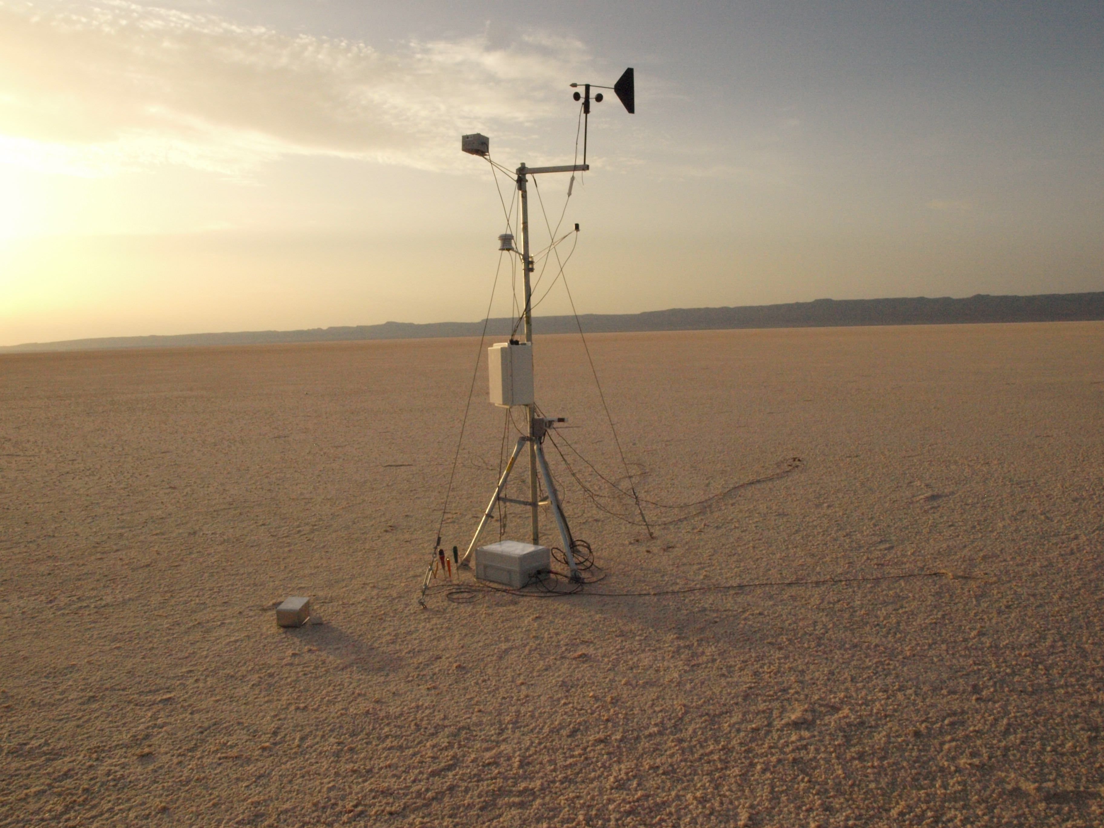
Just one of several weather stations set up at Chott El Jerid, a Tunisian saltpan, measuring temperature, humidity, ultraviolet radiation, wind direction and velocity. Image credit: Felipe Goméz/Europlanet
From orbit and on the ground, Mars looks inhospitable. But it doesn’t look much different than the freezing Antarctic plains, sun-baked saltpans in Tunisia or Spain’s corrosively acidic Rio Tinto, according to a few explorers from the Centro de Astrobiología (CAB) in Madrid, who today presented some of their findings of life during a press conference at the European Planetary Science Congress.
The biggest difference, however, is that life still thrives in these extreme locales on Earth.
“The big questions are: what is life, how can we define it and what the requirements for supporting life?” asks project leader Dr. Felipe Goméz. “To understand the results we receive back from missions like Curiosity, we need to have detailed knowledge of similar environments on Earth. Metabolic diversity on Earth is huge. We have found a range of complex chemical processes that allow life to survive in unexpected places.”
Over the past four years, Goméz and his colleagues have checked Earth’s most inhospitable locales; the Chott el Jerid saltpan in Tunisia, the Atacama Desert in Chile, Rio Tinto in southern Spain and Deception Island in Antarctica.
While visiting Chott el Jerid, the team tracked huge changes in environmental conditions throughout the day but it was a small rise in surface temperature after dusk that caught their eye. “We found that this is caused by water condensing on the surface and hydrating salts which releases heat in an exothermic reaction,” he said in the press release. This is very interesting from the perspective of the REMS instrument on Curiosity — it gives us away to follow when liquid water might be present on the surface.”
The team also built a three-dimensional picture of the subsurface in the saltpan by measuring the electrical properties of the soil. While drilling several meters into the subsurface at Chott el Jerid and in the Atacama Desert, researchers found bacteria at depth that was completely isolated from the surface. The researchers found not only bacteria, but also single-celled halophilic organisms that are able to oxidize metabolites under both aerobic and anaerobic conditions.
Along the surface of Chott El Jerid, which is made up of very pure sodium chloride with a trace of other salts, the team found small pieces of organic matter within the salt crystals. Once analyzed, they found populations of halophilic, salt-loving, dormant bacteria. In the laboratory, they were able to rehydrate the samples and bring the bacteria back to life, Goméz said.
Another unexpected find occurred while studying outcrops of the mineral jarosite at Rio Tinto in Spain. Jarosite, found on the surface of Mars by the Mars Exploration Rover Opportunity, forms only in the presence of water that contains high concentrations of metals, such as iron. The outcrops at Rio Tinto also are extremely corrosive. Yet, sandwiched between layers in the salt crusts, the team found photosynthetic bacteria. Unexpectedly, iron in the salt crust seems to protect bacteria from ultraviolet radiation, Goméz said. Samples of bacteria with iron present were exposed with high levels of ultraviolet radiation. They survived while bacteria samples without iron were destroyed.
“What the bacteria we found in Rio Tinto show is that the presence of ferric compounds can actually protect life. This could mean that life formed earlier on Earth than we thought. These effects are also relevant for the formation of life on the surface of Mars,” says Goméz. The team also found that salt provides stable conditions that can allow life to survive in very hard environments.
“Within salts, the temperature and humidity are protected from fluctuations and the doses of ultraviolet radiation are very low,” explained Goméz. “In the laboratory, we placed populations of different bacteria between layers of salt a few millimetres thick and exposed them to Martian conditions. Nearly 100% of deinoccocus radiodurans, a hardy type of bacteria survived being irradiated. But fascinatingly, about 40% of acidithiobacillus ferrooxidans – a very fragile variety of bacteria – also survived when protected by a salt crust.”
The findings have implications not only for studying possible life on Mars, but also for the development of life on early Earth.
Source: European Planetary Science Congress (EPSC) 2012 Press Release
Image Details: Photosynthetic bacteria at Rio Tinto. Credit: Felipe Goméz
About the author: John Williams is owner of TerraZoom, a Colorado-based web development shop specializing in web mapping and online image zooms. He also writes the award-winning blog, StarryCritters, an interactive site devoted to looking at images from NASA’s Great Observatories and other sources in a different way. A former contributing editor for Final Frontier, his work has appeared in the Planetary Society Blog, Air & Space Smithsonian, Astronomy, Earth, MX Developer’s Journal, The Kansas City Star and many other newspapers and magazines. Follow John on Twitter @terrazoom
Today, on the 11th anniversary of the World Trade Center attack, countless hearts and minds will be reflecting upon a day that changed our world forever and remembering those who lost their lives in the tragic collapse of the twin towers. Memorial events will be held in many locations around the planet… and even, in a small yet poignant way, on another planet. For, unknown to many, two pieces of the World Trade Center are currently on the surface of Mars: one affixed to the rover Spirit, now sitting silently next to a small rise dubbed “Home Plate”, and the other on its sister rover Opportunity, still actively exploring the rim of Endeavour crater.
Even more than scientific exploration tools, these rovers are also interplanetary memorials to all the victims of 9/11.
(The following is a repost of an article first featured on Universe Today in 2011, on the 10th anniversary of 9/11.)
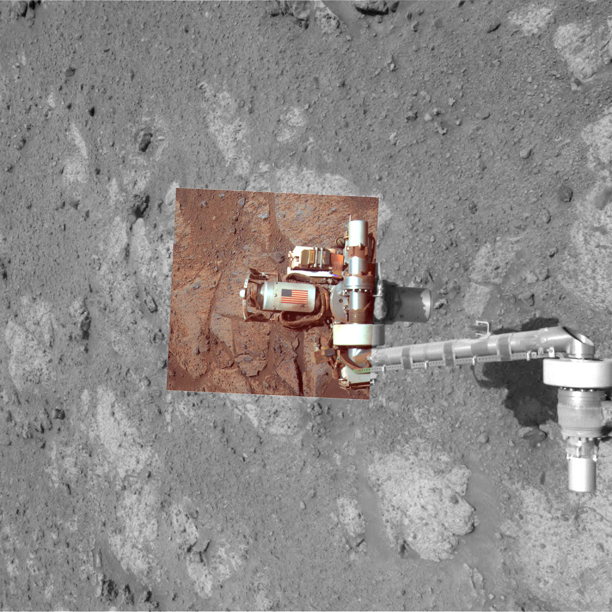
In September of 2001 workers at Honeybee Robotics in lower Manhattan were busy preparing the Rock Abrasion Tools that the twin rovers Spirit and Opportunity would each be equipped with, specialized instruments that would allow scientists to study the interiors of Martian rocks. After the World Trade Center attacks occurred, the company wanted a way to memorialize those who had lost their lives.
Through what was undoubtedly some incredibly skillful use of contacts, Honeybee founder and MER science team member Stephen Gorevan – on a suggestion by JPL engineer Steve Kondos and with help from the NYC mayor’s office and rover mission leader Steve Squyres – was able to procure two pieces of aluminum from the tower debris. These were fashioned into cylindrical cable shields by a contracted metal shop in Round Rock, Texas, and had American flags adhered to each by Honeybee engineer Tom Myrick.
The image above, taken in 2004, shows the cable shield with American flag on the Rock Abrasion Tool attached to Spirit. At right is an image of the flag shield on Opportunity, acquired on September 11, 2011.
The rovers were launched in the summer of 2003 and have both successfully operated on Mars many years past their planned initial mission timelines. Spirit currently sits silent, having ceased communication in March 2010, but Opportunity is still going strong in its exploration of the Martian surface.
“It’s gratifying knowing that a piece of the World Trade Center is up there on Mars. That shield on Mars, to me, contrasts the destructive nature of the attackers with the ingenuity and hopeful attitude of Americans.”
– Stephen Gorevan, Honeybee Robotics founder and chairman
These memorials will remain on Mars long after both rovers have ceased to run, subtle memorials to thousands of lives and testaments to our ability to forge ahead in the name of hopefulness and discovery.
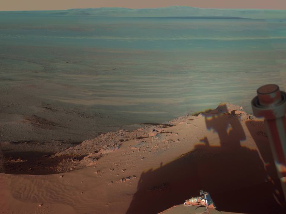
Opportunity's shadow aims eastward to the rim of Endeavour crater
[/caption]
The rover Opportunity captured a view into Endeavour crater as a low Sun cast a long shadow in this image, acquired back on March 9.
Endeavour is a large crater — 14 miles (22 km) wide, it’s about the same area as the city of Seattle. Opportunity arrived at its edge in August of 2011 after several years of driving across the Meridiani Plains.
Opportunity is currently the only operational manmade object on the surface of Mars… or any other planet besides Earth, for that matter. It’s a distinction it will hold until the arrival of Mars Science Laboratory at Gale Crater this August.
The scene is presented in false color to emphasize differences in materials such as dark dunes on the crater floor. This gives portions of the image an aqua tint.
Opportunity took most of the component images on March 9, 2012, while the solar-powered rover was spending several weeks at one location to preserve energy during the Martian winter. It has since resumed driving and is currently investigating a patch of windblown Martian dust near its winter haven.
Opportunity and its rover twin, Spirit, completed their three-month prime missions on Mars in April 2004. Both rovers continued for years of bonus, extended missions. Both have made important discoveries about wet environments on ancient Mars that may have been favorable for supporting microbial life. Spirit stopped communicating in 2010. Since landing in the Meridiani region of Mars in January 2004, Opportunity has driven 21.4 miles (34.4 kilometers).
Image credit: NASA/JPL-Caltech/Cornell/Arizona State University
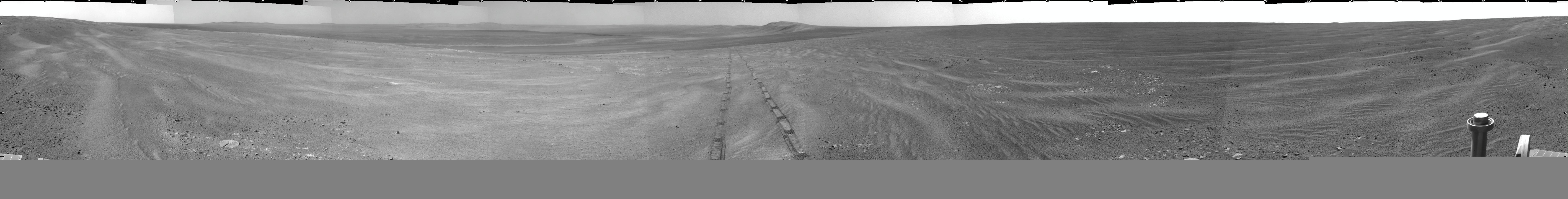
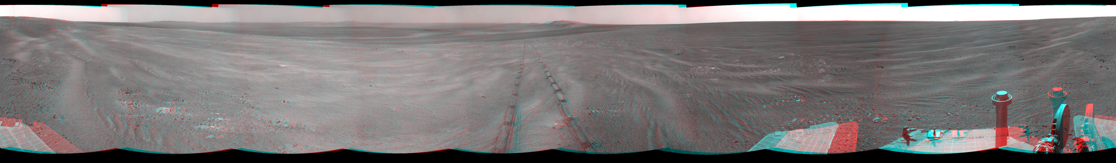
Opportunity - Panoramic view inside vast Endeavour Crater snapped ascending Cape York crater ridge on Sol 2754, October 23, 2011. Opportunity wheel tracks at right. Cape Tribulation and distant, far side Endeavour crater rim in background. Opportunity is now driving to the northern tip of Cape York in search of a winter haven to survive upcoming brutal Martian Antarctic winter temperatures. Credit: NASA/JPL/Cornell. See the entire panorama in 2 D and 3 D and route maps below.
[/caption]
NASA’s intrepid robogirl Opportunity is now swiftly scouting out locations at a Martian hill along gigantic Endeavour crater that would simultaneously proffer a goldmine of sun and science as her power level drops significantly in these waning days of Martian autumn ahead of the absolutely brutal and potentially deadly 6 month long Antarctic winter that’s fast approaching. Opportunity has just discovered a geologic vein possibly formed as a result of flowing water eons ago.
But, search time for a sunny exposure at the Martian hill known as Cape York is running out says the Mars rover team in new interviews with Universe Today. Recall that lack of power and utterly frigid temperatures killed her twin sister Spirit last winter.
“Martian winter in the southern hemisphere starts on March 29, 2012 or Sol 2908. But, Solar power levels already begin dropping dramatically months before Martian winter starts,” said Alfonso Herrera to Universe Today, Herrera is a Mars rover mission manager at NASA’s Jet Propulsion Laboratory in Pasadena, Calif.
“Orbital imagery indicates that the northern-most tip of Cape York might have north facing slopes which Opportunity will need in order to generate enough solar power to sustain her comfortably throughout the winter,” Herrera explained to me.
The team is very excited about the science implications of the vein detection.
“The importance of veins is that often they occur from the deposition of material that was dissolved and transported by hot water in cracks deep underground,” said Bruce Banerdt to Universe Today. Banerdt is the Project Scientist for the Mars rover mission at JPL.
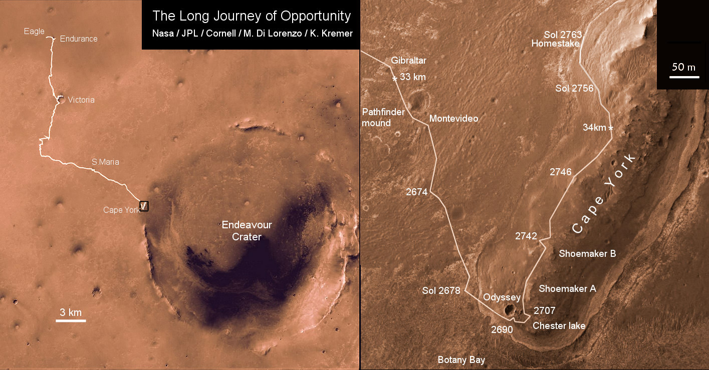
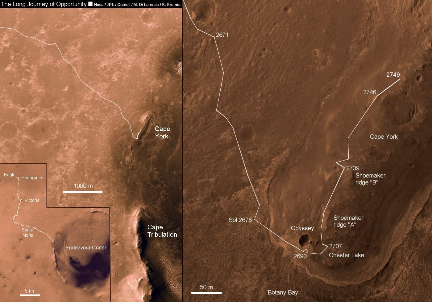
Traverse map showing the 7 Year Journey of Opportunity from Eagle Crater landing site Sol 1 (Jan. 24, 2004) to current location around Homestake on Sol 2763 (November 2011) at Cape York ridge at Endeavour Crater rim. Endeavour Crater is 14 miles or 22 kilometers in diameter. Opportunity has driven more than 21 miles (34 km). Credit: NASA/JPL/Cornell/Marco Di Lorenzo/Kenneth Kremer
Segments of Endeavour’s rim at Cape York and Cape Tribulation about 6 kilometers further south offers scientifically rich motherlodes of phyllosilicate clay minerals and other water bearing minerals that formed Billions of years ago on Mars and that could possibly point to habitats favorable for the genesis and support of Martian microbial life forms if they ever existed in the past or present.
Opportunity is currently traversing about the hilltops and slopes of Cape York where she recently made landfall after an epic three year trek across the plains of the Meridiani Planum region of Mars.
Initial reconnaissance around the southern tip and then climbing on top of the central ridge of Cape York have already yielded a bonanza of new science data at rock types never seen before on Mars, according to Steve Squyres, the Mars Rover Principal Investigator of Cornell University.
The rover is now driving north and back down around the base while searching for a “winter haven” with more potential for great science and a northerly inclined slope to more efficiently catch the sun’s rays.
“Opportunity is heading north to find the best winter site,” Ray Arvidson told Universe Today. Arvidson is the rover’s deputy principal investigator, of Washington University in St. Louis.
“We are more than halfway toward the northern part of Cape York where there are slopes steep enough to provide an energy-valid winter site and where science can take place. Now we are driving away from the predicted outcrops [of smectite clay minerals] on Cape York and onto the bench on the western side because we have run out of time to investigate these outcrops.”
Opportunity - Wide panoramic view inside vast Endeavour Crater snapped ascending Cape York crater ridge on Sol 2754, October 23, 2011. Opportunity wheel tracks at center. Cape Tribulation and distant, far side Endeavour crater rim in background. Opportunity is now driving to the northern tip of Cape York in search of a winter haven to survive upcoming brutal Martian Antarctic winter temperatures. Credit: NASA/JPL/Cornell
However, the rover team was still hoping to catch a break for science opportunities along the way north and just chanced upon geologic veins potentially indicative of past flow of liquid water.
“The bench around the edge of Cape York looks like sedimentary rock that’s been cut and filled with veins of material possibly delivered by water,” says Arvidson.
3 D Opportunity Panorama - 3 D Wide panoramic view inside vast Endeavour Crater snapped ascending Cape York crater ridge on Sol 2754, October 23, 2011. Opportunity wheel tracks at center. Cape Tribulation and distant, far side Endeavour crater rim in background. Opportunity is now driving to the northern tip of Cape York in search of a winter haven to survive upcoming brutal Martian Antarctic winter temperatures. Credit: NASA/JPL/Cornell
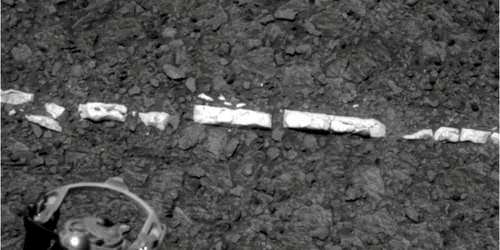
Opportunity has just driven to a light toned vein at a spot dubbed “Homestake” and will spend a few sols (martian days) investigating with all the tools on the terminus of the robotic arm – including some Microscopic Imager (MI) images of the vein and placing the Alpha Particle X-ray Spectrometer (APXS) on top for overnight integrations.
“Opportunity will then continue traveling on the outboard side of Cape York (i.e. facing the plains),” Herrera told Universe Today.
“Plans are subject to change, but currently, Opportunity will travel to the north end of Cape York and stay there for the winter if suitable north facing slopes are found.”
“Our hope is that once a winter haven is identified, Opportunity will have enough power to make brief forays for science gathering in the vicinity of the winter haven,” Herrera informed me.
Homestake vein close up on Sol 2765- November 3, 2011. RAT (Rock Abrasion Tool) at lower left will target Homestake. Credit: NASA/JPL/CornellOpportunity Panorama at Cape York Ridge at Endeavour Crater - November 2011
Opportunity rover is exploring around the base of Cape York hill at the bench and vein features which may hold clues to the ancient flow of liquid water here on Mars. Opportunity drives North (ahead) from here in search of a sunny winter haven. Mosaic Credit: NASA/JPL/Cornell/Kenneth Kremer/Marco Di Lorenzo
Opportunity’s power levels have dropped by nearly 25 percent in the past few months – as Martian dust builds up – and are hovering around 300 watts-hours , which is less than a third of the maximum output possible from her life giving solar arrays.
Her sparkling wing-like solar panels boasted an output of some 950 watt-hours upon landing on Mars nearly 8 years ago – for a mission warrentied to last a mere 90 Martian Days, or Sols. That equates to 31 times beyond the design lifetime !
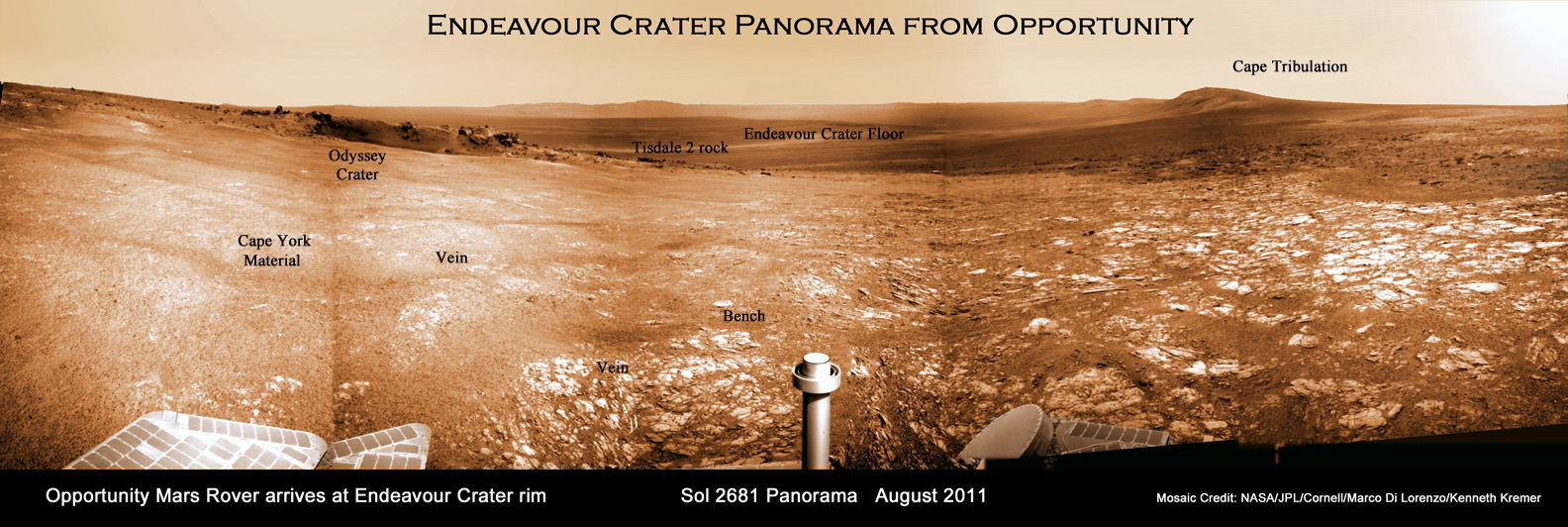
Endeavour Crater Panorama from Opportunity, Sol 2681, August 2011
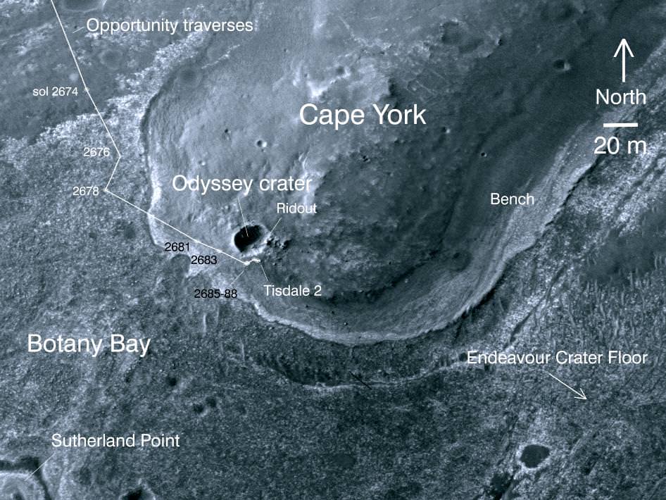
Opportunity arrived at the rim of Endeavour on Sol 2681, August 9, 2011 and climbed up the ridge known as Cape York. Odyssey crater is visible at left. Opportunity is now driving to the northern tip of Cape York (to the left) and is investigating a geologic vein that indicates flow of liquid water. Opportunity was photographed from Mars orbit on Sept. 10, 2011.
Mosaic Credit: NASA/JPL/Cornell/Marco Di Lorenzo/Kenneth Kremer
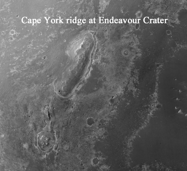
Cape York is a low ridge that belongs to the rim of humongous Endeavour crater, some 14 miles or 22 kilometers in diameter that offers spectacular panoramic vistas peering into the vast and beautiful crater sporting a huge central mound and mountainous rim segments both near and far.
Opportunity arrived at Cape York and Endeavour Crater in August 2011 after an overland expedition of more than 21 miles (34 km).
NASA’s Curiosity rover is on course to liftoff for Mars on Nov. 25
Traverse map showing the 7 Year Journey of Opportunity from Eagle Crater landing site to current location at Cape York ridge at Endeavour Crater rim. Credit: NASA/JPL/Cornell/Marco Di Lorenzo/Kenneth Kremer
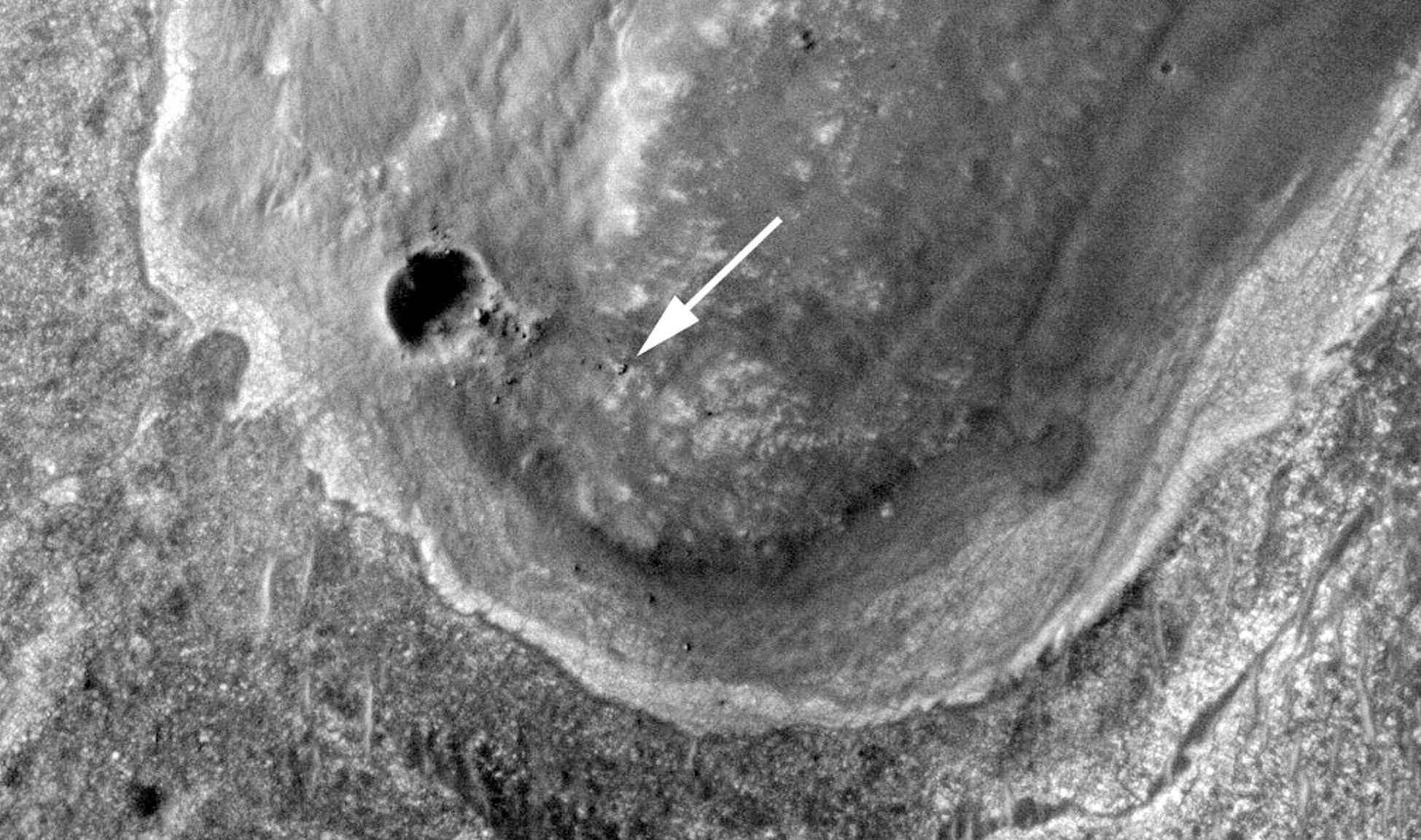
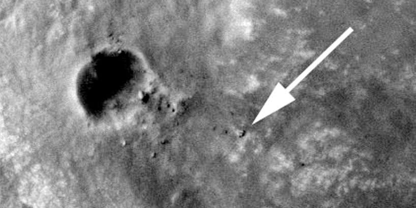
Opportunity captured at Endeavour Crater rim on Sept 10, 2011, Sol 2712. Opportunity is visible at the end of the white arrow, sitting atop some light toned outcrops on the rim of Endeavour Crater located at the southern tip of a rim segment named Cape York. Opportunity is ascending Endeavour at Cape York ridge and positioned to the right of the small crater named Odyssey. This image was taken by the HiRISE camera aboard NASA’s Mars Reconnaissance Orbiter (MRO), Opportunity travelled nearly three years to reach this rim because it contains rocks even more ancient than the rocks of Meridiani Planum, which the rover has been exploring since 2004, and hence may teach us something about an even more ancient era in Martian history. Click to enlarge. Credit: NASA/JPL/University of Arizona
[/caption]
Opportunity has just been imaged in high resolution at Endeavour crater by a powerful NASA camera orbiting overhead in Mars orbit. The new image (see above) was snapped while NASA’s long lived robot was climbing a hilltop offering spectacular panoramic vistas peering into the vast crater which is some 14 miles (22 km) wide.
The HiRiSE camera aboard NASA’s Mars Reconnaissance Orbiter photographed Opportunity and her wheel tracks on September 10, 2011, or Martian Sol 2712 for a mission warrentied to last only 90 Sols ! The rover is sitting to the right of another small crater known as Odyssey. Click to enlarge the image.
Look very closely and you’ll even be able to easily discern the rovers pair of tire tracks showing the path traversed by the robot as she explores the crater and the ejecta rocks and boulders excavated and strewn about by an ancient impact.
Opportunity imaged at Endeavour crater rim with wheel tracks exploring Odyssey crater, rocks and boulders climbing up Cape York ridge. Credit: NASA/JPL/University of Arizona
Opportunity is ascending up the rim of Endeavour crater at the southern tip of a low ridge dubbed Cape York – a location that has already yielded a bonanza of new science data since her recent arrival in August 2011 after a more than 20 mile (33 km) epic trek.
The intrepid rover discovered a rock unlike any other since she safely landed at the Meridiani Planum region of Mars nearly eight years ago on Jan. 24, 2004.
Opportunity is now searching Endeavour crater and Cape York for signatures of phyllosilicates – clay minerals that formed in the presence of pH neutral water flowing on Mars surface billions of years ago. Cape York ridge at Endeavour Crater - From Orbit
This image taken from Mars orbit shows the path driven by NASA's Mars Exploration Rover Opportunity in the weeks around the rover's arrival at the rim of Endeavour crater and up to Sol 2688. Opportunity has since driven a short distance to the right. Credit: NASA/JPL-Caltech/University of Arizona
Endeavour Crater Panorama from Opportunity, Sol 2681, August 2011
Opportunity arrived at the rim of Endeavour on Sol 2681, August 9, 2011 and climbed up the ridge known as Cape York. Odyssey crater is visible at left. Opportunity has since driven a short distance beyond Odyssey crater and was photographed from Mars orbit on Sept. 10, 2011.
Mosaic Credit: NASA/JPL/Cornell/Marco Di Lorenzo/Kenneth Kremer
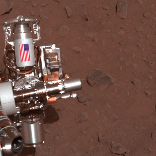
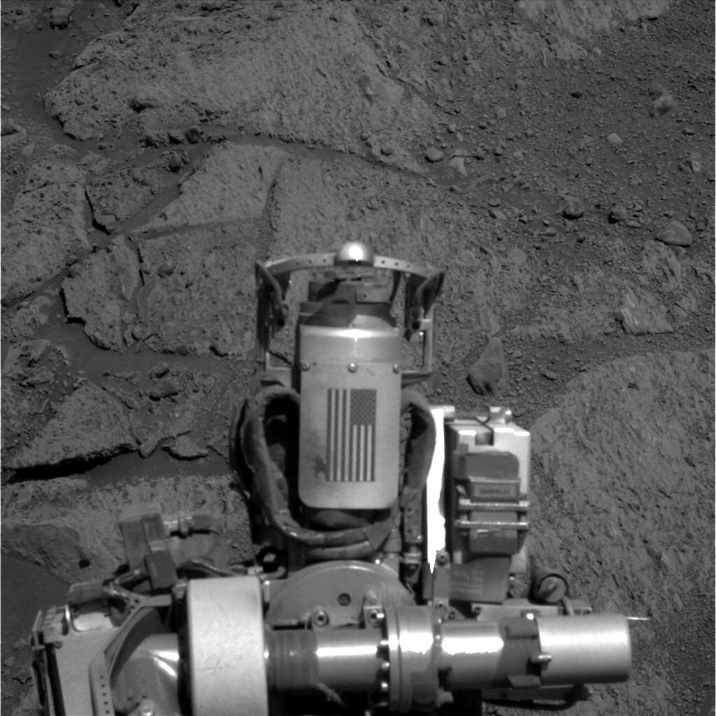
Memorial Image Taken on Mars on Sept. 11, 2011. This view of an American flag on metal recovered from the site of the World Trade Center towers shortly after their destruction on Sept. 11, 2001, was taken on Mars by NASA’s Opportunity rover on Sept. 11, 2011, the 10th anniversary of the attacks on the towers. Credit: NASA/JPL-Caltech/Cornell University/Arizona State University
[/caption]
On this somber occasion marking the 10th anniversary of the tragic events of 9/11, NASA’s Opportunity Mars rover has taken new images of itself on 9/11/11 showing a piece of metal recovered from the wreckage of the Twin Towers of the World Trade Center in New York City that was carried all the way to the planet Mars as a commemorative memorial to the innocent victims of the terrorist attacks of Sept 11, 2001.
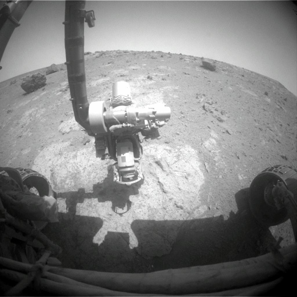
On Sept. 11, 2011 (Martian Sol 2713), Opportunity snapped the memorial image above showing the Rock Abrasion Tool (RAT) and an American Flag – evoking the memory of the Twin Towers – from a slope on a Martian hill named Cape York which in turn is a segment of the rim of a gigantic crater named Endeavour.
Opportunity is still roving the red planet’s surface, nearly 8 years after safely landing on Jan 24, 2004. After an epic trek she recently arrived at the gigantic 14 mile wide Endeavour crater .
Opportunity took the new image of the RAT and 9/11 US Flag memorial on Mars on the exact day timed to coincide with the 10th anniversary of the attacks.
The image shows the arm extended for inspection of target on a rock called “Chester Lake”, according to NASA officials. Opportunity is driving in a northerly direction up the Cape York hill on her scientific expedition of the crater’s rim.
Memorial Close-up Image Taken on Mars on Sept. 11, 2011
Close-up image taken on 9/11/11 of a piece of metal with the American flag on it of a NASA’s Opportunity rover on Mars is made of aluminum recovered from the site of the World Trade Center towers in the weeks after their destruction on Sept. 11, 2001. Credit: NASA/JPL-Caltech/Cornell University/Arizona State University
Both towers of the World Trade Center in New York City were destroyed by the terrorists on that terrible day and nearly 3000 precious people were killed during horrifying historic events that changed America and the World forever.
The RAT was built for NASA and both rovers by Honeybee Robotics which at that time was located less than a mile away from the WTC near the southern tip of Manhattan.
Steve Gorevan, the founder and chairman of Honeybee and a member of the rover science team, told me in a past interview that he was on his way to work and out on the city streets within a few blocks of the Twin Towers when he suddenly heard the sounds of the jet engines just before the first tower was struck.
Gorevan and the Honeybee employees watched the tragic events unfold from their company’s offices and rooftop the rest of the day. Following the terror attacks, Gorevan said access to Honeybee was restricted for weeks and the firm was on a tight deadline to deliver the RAT’s to NASA and the Jet Propulsion Laboratory in California where the rovers were being assembled.
The idea for somehow placing a Martian memorial on the rovers was presented. Gorevan told me that he was able to secure metallic pieces from the WTC wreckage through the Office of the then NYC Mayor Rudy Guiliani a few weeks after the attacks.
Memorial Image Taken on Mars on Sept. 11, 2011 of Robotic Arm at Work showing US Flag 9/11 Memorial on the Rock Abrasion Tool (RAT). Image taken on Sol 2713 as the robot investigates a rock outcrop called Chester Lake. Credit: NASA/JPL-Caltech
Aluminum shards were delivered by the Mayor’s office to Honeybee along with a note indicating their authenticity. These were soon fashioned into an aluminum shield that was placed on each RAT along with a US Flag. The shield serves as a cable guard.
Gorevan says the twin towers memorial was purposely kept quiet for some time until well after both rovers landed out of respect for the victims’ families.
Opportunity is healthy and continuing her exploration of Endeavour crater which harbors geologic formations and rocks unlike any previously investigated by either of the Mars Exploration (MER) rovers.
Along the rim of Endeavour crater rover scientists hope to discover and analyze clay minerals which formed in pH neutral water billions of years ago and a habitable environment much more favorable to the formation of life compared to all the other spots studied by either rover thus far.
Both rovers far exceeded their original 90 days warranties with many years of added bonus time for science exploration.
Endeavour Crater Panorama from Opportunity, Sol 2681, August 2011
Opportunity arrived at the rim of Endeavour on Sol 2681, August 9, 2011 and climbed up the ridge known as Cape York. Odyssey crater is visible at left. Opportunity drove north from here to snap a new 9/11 memorial image on Sept 11, 2011 marking the 10th anniversary of the 9/11 terrorist attacks.
Mosaic Credit: NASA/JPL/Cornell/Marco Di Lorenzo/Kenneth Kremer