Imminent Impact of Deadly Cat 4 Hurricane Matthew Forces Closure of Kennedy Space Center and Mass Coastal Evacuations

Cat 4 Hurricane Matthew track during the late evening of 6 Oct 2016. Credit: NASA/NOAA
Cat 4 Hurricane Matthew track during the late evening of 6 Oct 2016.  Credit: NASA/NOAA
Cat 4 Hurricane Matthew track during the late evening of 6 Oct 2016. Credit: NASA/NOAA

The imminent impact of the already deadly Category 4 Hurricane Matthew along the Florida Space Coast tonight, Thursday, October 6, has forced the closure of NASA’s Kennedy Space Center (KSC) and mass evacuations along the US East coast from Florida, to Georgia to the Carolinas.

“Hurricane Matthew, currently an extremely dangerous Category 4 storm on the Saffir-Simpson Hurricane Wind Scale, continues to bear down on the southeastern United States,” says NASA in an update today.

NASA has closed KSC for today and tomorrow, at a minimum and the center has entered HurrCon 1 status.

“Under the current storm track, peak winds are forecast to be 125 mph sustained with gusts to 150 mph, however a shift in the track even slightly could improve the wind forecast somewhat,” wrote NASA’s Brian Dunbar.

“The Kennedy Space Center is closed today, Oct. 6, and Friday for Hurricane Matthew. Kennedy Space Center is now in HurrCon 1 status, meaning a hurricane is imminent.”

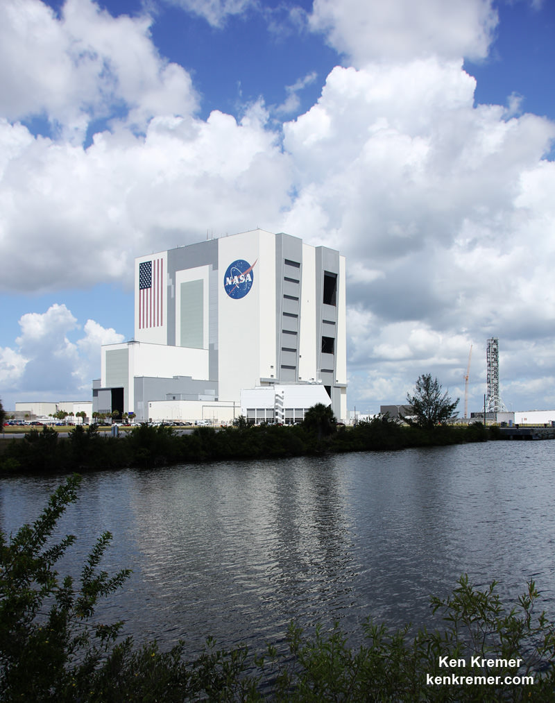
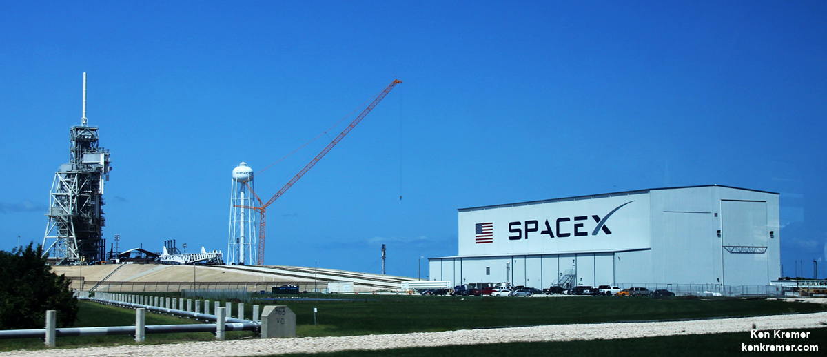
The Kennedy Space Center on Florida’s Space Coast is home to the iconic Vehicle Assembly Building (VAB) – the most well known building at NASA – as well as Launch Complex’s 39 A and B which launched American astronauts to Moon and thereafter Space Shuttles for three decades.

The launch pads sit precariously close to the Atlantic Ocean shoreline – just a few hundred yards (meters) away!

View of the VAB and Mobile Launcher from the KSC Launch Complex 39 Press Site.   NASA is upgrading the VAB with new platforms to assemble and launch  NASA’s Space Launch System rocket at the Kennedy Space Center in Florida.  Credit: Ken Kremer/kenkremer.com
View of the VAB and Mobile Launcher from the KSC Launch Complex 39 Press Site. NASA is upgrading the VAB with new platforms to assemble and launch NASA’s Space Launch System rocket at the Kennedy Space Center in Florida. Credit: Ken Kremer/kenkremer.com

“Across the spaceport, essential personnel are preparing facilities for the storm’s arrival,” according to George Diller, NASA Kennedy Space Center Public Affairs Officer.

“Hurricane Matthew is expected to make its closest approach to the Cape Canaveral/Kennedy area overnight Thursday and into Friday morning, bringing with it the potential for heavy rain, storm surge and hurricane-force winds.”

The last time a major Hurricane impacted near KSC and the Space Coast was in 2004. The VAB suffered some outside damage.

The Kennedy Space Center Visitor Complex is also closed on Thursday, October 6 and Friday, October 7.

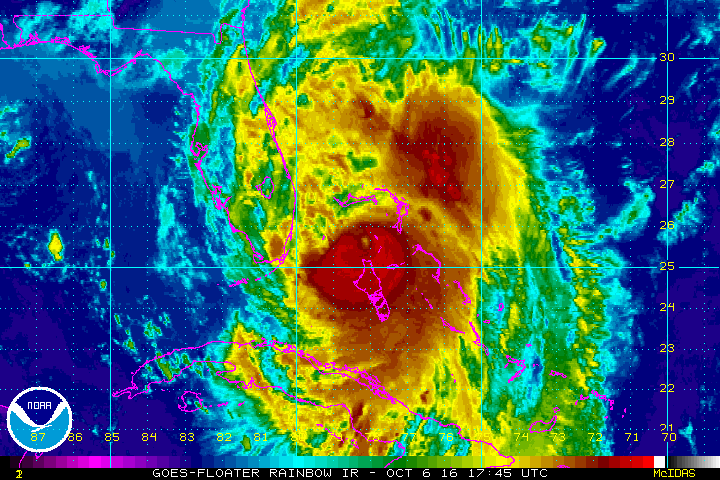
Hurricane Matthew is bearing down on the US East Coast right now at Florida’s Peninsula and is tracking north.

This visible image on Oct. 6 at 1:00 p.m. EDT from NOAA's GOES-East satellite shows Hurricane Matthew as it regained Category 4 Hurricane Status.  Credits: NASA/NOAA GOES Project
This visible image on Oct. 6 at 1:00 p.m. EDT from NOAA’s GOES-East satellite shows Hurricane Matthew as it regained Category 4 Hurricane Status. Credits: NASA/NOAA GOES Project

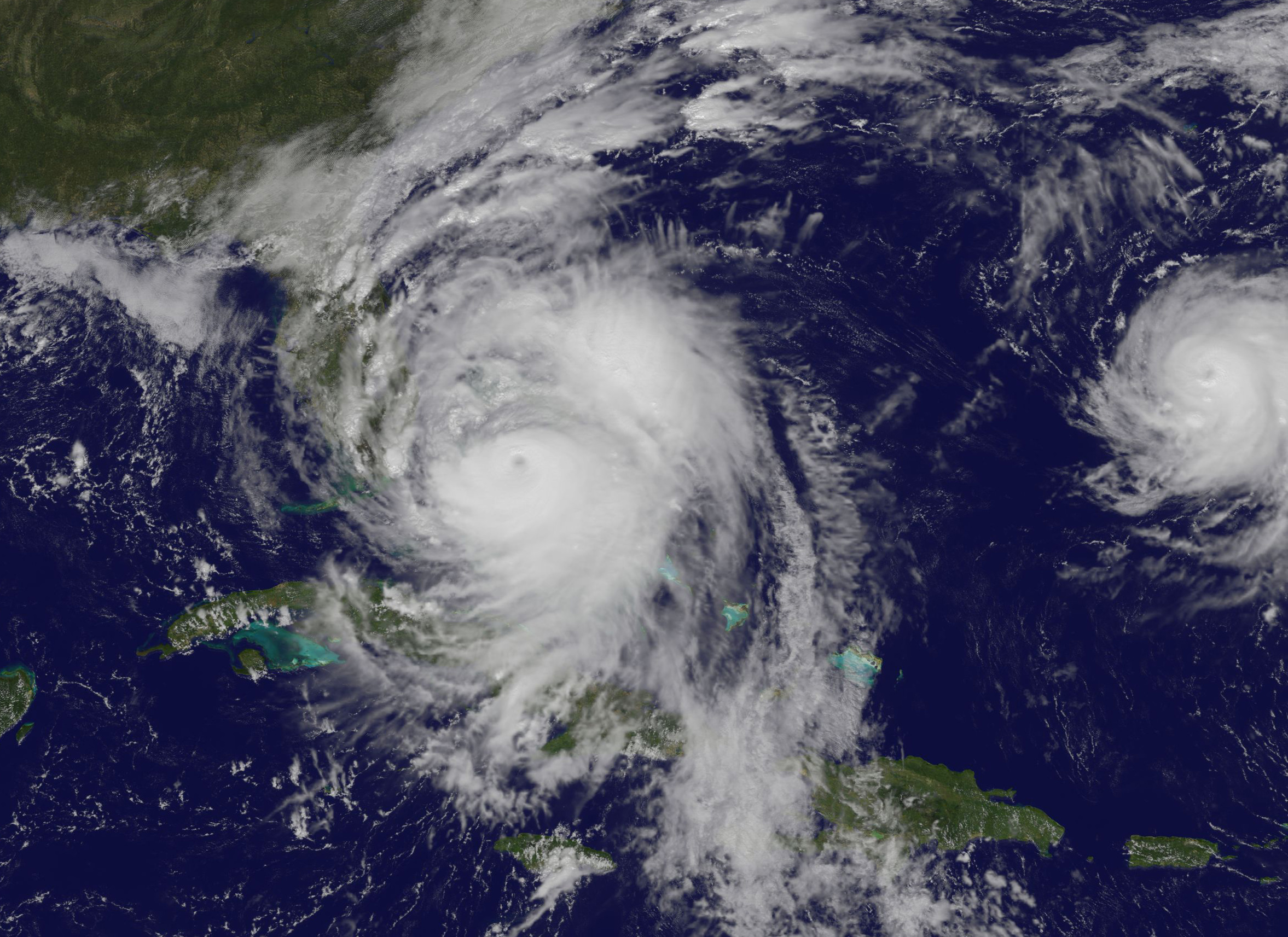
Herein is the latest satellite imagery from NASA and NOAA of this evening.

Mass evacuations have been ordered and States of Emergencies declared by the Governors of Florida, Georgia and North and South Carolina.

The high winds, storm surge of potentially 5 to 11 feet, drenching rains and extensive flooding is expected to cause massive damage and devastation to homes, businesses and infrastructure.

Cat 4 Hurricane Matthew track during the late evening of 6 Oct 2016.  Credit: NASA/NOAA
Cat 4 Hurricane Matthew track during the late evening of 6 Oct 2016. Credit: NASA/NOAA

Hundreds of thousands of folks have left their home over the past 2 days. Many gas stations are dry and grocery store shelves emptied.

Matthew will cause a wide swath of destruction and potentially deaths along hundreds of miles of US shoreline and inland areas as the massive storm hugs the coast like none before in recorded history.

Furthermore, hundreds of thousands of folks are expected to lose power as well, for days and perhaps weeks.

Hundreds of deaths and massive destruction in Haiti, Cuba and elsewhere in the Caribbean can already be blamed on Hurricane Matthew – a storm like none other and by far the worst since Superstorm Sandy and Hurricane Katrina.

After the storm passes KSC will evaluate all its facilities.

“Once the storm has passed, center facilities and infrastructure will be assessed and employees will be cleared to return when it is safe to do so,” Diller.

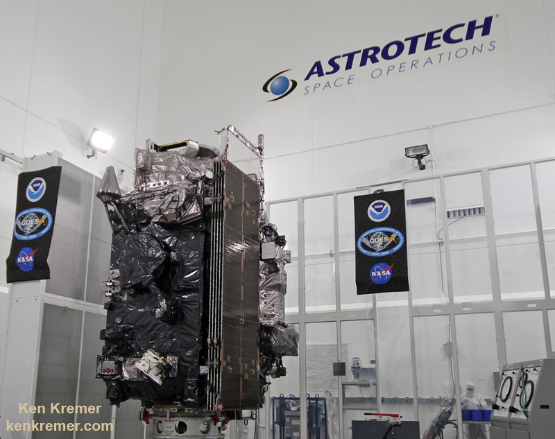
Indeed NASA was preparing to launch America’s newest and most advanced weather satellite on Nov 4. It’s named GOES-R and was slated for blastoff from Cape Canaveral Air Force Station atop a ULA Atlas V on Nov. 4.

The launch facilities will have to be thoroughly inspected before the launch can proceed.

The satellite is in the final stages of preparation at the Astrotech Space Operations Facility in Titusville, FL as I recently observed during an up close visit in the High Bay cleanroom.

Titusville and Astrotech could suffer a direct hit from Matthew. But the satellite has been secured.

The NASA/NOAA GOES-R (Geostationary Operational Environmental Satellite - R Series) being processed at Astrotech Space Operations, in Titusville, FL, in advance of the planned launch on a ULS Atlas V on Nov 4, 2016.  GOES-R will be America’s most advanced weather satellite. Credit: Ken Kremer/kenkremer.com
The NASA/NOAA GOES-R (Geostationary Operational Environmental Satellite – R Series) being processed at Astrotech Space Operations, in Titusville, FL, in advance of the planned launch on a ULS Atlas V on Nov 4, 2016. GOES-R will be America’s most advanced weather satellite. Credit: Ken Kremer/kenkremer.com

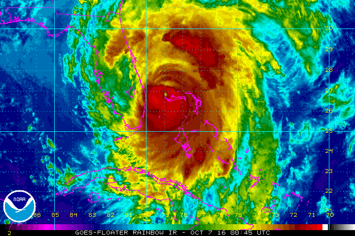
Here is the latest Advisory from the National Hurricane Center (NHC) as of 8 PM EDT Oct 6.

At 800 PM EDT (0000 UTC), the eye of Hurricane Matthew was located over the western end of Grand Bahama Island near latitude 26.6 North, longitude 78.9 West. The hurricane is moving toward the northwest near 13 mph (20 km/h), and this general motion is expected to continue tonight with a turn toward the north-northwest early Friday. On the forecast track, the eye of Matthew should move away from Grand Bahama Island during the next few hours, and move close to or over the east coast of the Florida peninsula through Friday night.

Reports from a NOAA Hurricane Hunter aircraft indicate that maximum sustained winds are now near 130 mph (210 km/h) with higher gusts. Matthew is a category 4 hurricane on the Saffir-Simpson Hurricane Wind Scale. Some fluctuations in intensity are likely while the hurricane moves toward the coast of Florida.

Hurricane-force winds extend outward up to 60 miles (95 km) from the center and tropical-storm-force winds extend outward up to 185 miles (295 km). Settlement Point in the Bahamas recently reported a sustained wind of 79 mph (128 km/h) with a gust of 105 mph (169 km/hr). The Lake Worth Pier near Palm Beach, Florida, recently reported a sustained wind of 46 mph (74 km/h) and a wind gust of 60 mph (96 km/h).

The minimum central pressure estimated from NOAA Hurricane Hunter data is 939 mb (27.73 inches).

…….

The latest weather briefing indicates that “tropical storm force winds beginning at Cape Canaveral tonight at midnight with hurricane force winds starting at about 6 a.m.

A hurricane ride-out crew of 116 has arrived at KSC this evening to prepare for Matthew.

“All facilities at Kennedy Space Center and Cape Canaveral Air Force Station have been secured.”

SpaceX is currently renovating and refurbishing pad 39A to launch their commercial Falcon 9 and Falcon Heavy rockets as well the Crew Dragon with astronauts on mission to the ISS.

The eye of the storm is barreling towards KSC at this moment. Stay tuned for the outcome.

SpaceX is renovating Launch Complex 39A at the Kennedy Space Center for launches of the Falcon Heavy and human rated Falcon 9.  Credit: Ken Kremer/kenkremer.com
SpaceX is renovating Launch Complex 39A at the Kennedy Space Center for launches of the Falcon Heavy and human rated Falcon 9. Credit: Ken Kremer/kenkremer.com

Stay tuned here for Ken’s continuing Earth and Planetary science and human spaceflight news.

Ken Kremer

Danny – First Atlantic Hurricane of 2015 as Seen from Space Station by Scott Kelly

NASA Astronaut Scott Kelly took this picture of Hurricane Danny on August 20 at 6 a.m. EDT from aboard the International Space Station. Credits: NASA

Hurricane Danny, the first Atlantic Ocean hurricane of the 2015 season has been caught on camera by NASA astronaut Scott Kelly, in a beautiful image taken on Thursday, August 20 at 6 a.m. EDT from his glorious perch aboard the International Space Station (ISS).

Poking majestically down at the sprawling hurricane is the space stations Canadian-built robotic arm that will be used by Kelly in a few days to grapple Kounotori, the Japanese cargo ship launched earlier this week and berth it at a docking port.

Kelly is nearly five months into his year-long stay aboard the ISS and is a prolific photographer of the natural wonders of our home planet.

“Hurricane Danny. Keeping an eye on you from the International Space Station. Looks like you’re 1st in the Atlantic this year. Stay safe below! #YearInSpace,” wrote Kelly on his Facebook and twitter pages.

Danny had risen to a Category 3 hurricane by Friday afternoon, August 21, with winds over 115 mph and was moving westward in the Central Atlantic Ocean towards the Leeward Islands in the Caribbean.

By 11 a.m. EDT (1500 UTC) on Friday, August 21, the eye of Hurricane Danny was located near latitude 14.0 North, longitude 48.2 West, according to NASA. The center of Danny was about 930 miles (1,195 km) east of the Leeward Islands. With maximum sustained winds of near 105 mph (165 kph), Danny was a Category 2 hurricane on the Saffir-Simpson Hurricane Wind Scale.

By 8:00 p.m. Friday evening, Friday, the National Hurricane Center said Danny was located over the central tropical Atlantic Ocean about 800 miles east of the Leeward Islands.

Late this evening at 11 p.m., the National Hurricane Center said it had weakened slightly back to a Category 2 storm with maximum winds of 110 mph and was located at 14.8°N and 49.8°W while moving west northwest at 10 mph.

The NASA GOES-East animation below combines visible and infrared imagery showing Hurricane Danny’s movement in the eastern and central Atlantic Ocean from Aug. 18 to 21, 2015.

Video caption: Hurricane Danny Seen By GOES-East. This animation of visible and infrared imagery of Hurricane Danny in the Central Atlantic Ocean was taken from NOAA’s GOES-East satellite from Aug. 18 to 21. Credits: NASA/NOAA GOES Project

Forecasters with the National Hurricane Center think it may weaken over the next few days as it heads towards the Caribbean islands.

“Vertical shear is expected to increase further during the next couple of days, which should allow drier air in the surrounding environment to penetrate into Danny’s circulation. Therefore,there is no change in the thinking that Danny should weaken as it approaches and moves across the Leeward Islands and the Greater Antilles during the forecast period.”

Danny could reach Puerto Rico by Monday in a weakened state.

Although it’s still far away from the US, it’s not expected to impact the East Coast but that could change.

If Danny were to take aim at the US, it could impact plans to launch the Air Force MUOS-4 satellite on Aug. 31 from Cape Canaveral Air Force Station by United Launch Alliance (ULA).

Here’s a map showing the current location:

Hurricane Danny location on Aug. 21, 2015. Credit: National Hurricane Center

On Aug. 19, NASA’s Global Precipitation Measurement (GPM) mission core satellite passed over Danny and analyzed the structure of its rainfall, as seen in this image.

On Aug. 19, 2015 GPM saw Danny's rain structure was still asymmetric as noted by the large rain band (identified by the green arc indicating moderate rain) being located mainly on the eastern side of the storm. Within this rain band, GPM detected rain rates of up to 73.9 mm/hour (shown in darker red).Credits: SSAI/NASA, Hal Pierce
On Aug. 19, 2015 GPM saw Danny’s rain structure was still asymmetric as noted by the large rain band (identified by the green arc indicating moderate rain) being located mainly on the eastern side of the storm. Within this rain band, GPM detected rain rates of up to 73.9 mm/hour (shown in darker red).Credits: SSAI/NASA, Hal Pierce

A research team at NASA’s Goddard Space Flight Center in Greenbelt, Maryland, created a 3-D rendering of Danny using data from the GPM DPR (Dual-frequency Precipitation Radar) instrument.

“GPM showed that Danny was still in the process of becoming organized. The rain structure was still very asymmetric as noted by a large rain band being located mainly on the eastern side of the storm. Within this rain band, GPM detected rain rates of up to 73.9 mm/hour. At the time of this image, Danny was still a minimal tropical storm with sustained winds estimated at 50 mph by the National Hurricane Center (NHC),” said officials.

And dont forget that you can watch Commander Scott Kelly and his five international crew mates on a regular basis as they soar overhead. Just click on NASA’s Spot the Station link and plug in your location.

ISS crosses the Big Dipper over NJ.  Credit: Ken Kremer/kenkremer.com
ISS crosses the Big Dipper over NJ. Credit: Ken Kremer/kenkremer.com

Stay tuned here for Ken’s continuing Earth and planetary science and human spaceflight news.

Ken Kremer