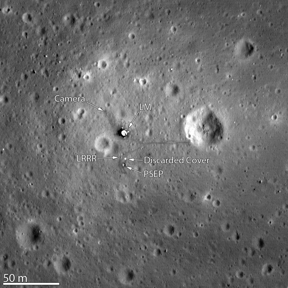
LROC image of the Apollo 11 landing site, acquired Nov. 5, 2011 (NASA/GSFC/Arizona State University)
[/caption]
Just over 42 years after Neil and Buzz became the first humans to experience the “stark beauty” of the lunar surface, the Lunar Reconnaissance Orbiter captured the remnants of their visit in the image above, acquired Nov. 5, 2011 from an altitude of only 15 miles (24 km). This is the highest-resolution view yet of the Apollo 11 landing site!
The Lunar Module’s descent stage, a seismic experiment monitor, a laser ranging reflector (LRRR, still used today to measure distances between Earth and the Moon) and its cover, and a camera can be discerned in the overhead image… as well as the darker trails of the astronauts’ bootprints, including Armstrong’s jaunt eastward to the rim of Little West crater.
The crater was the furthest the Apollo astronauts ventured; in fact, if you take the total area Neil and Buzz explored it would easily fit within the infield of a baseball diamond!
Neil Armstrong’s visit to the crater’s edge was an unplanned excursion. He used the vantage point to capture a panoramic image of the historic site:
Panorama of the Apollo 11 site from Little West crater. (NASA)
“Isn’t that something! Magnificent sight out here.” Armstrong had stated before he was joined by Aldrin on the lunar surface. “It has a stark beauty all its own. It’s like much of the high desert of the United States. It’s different, but it’s very pretty out here.”
Previously the LROC captured the Apollo 15 landing site, which included the tracks of the lunar rover — as well as the rover itself! And, just yesterday, the LROC site operated by Arizona State University featured the latest similarly high-resolution view of the Apollo 12 site. This location has the honor of being two landing sites in one: Apollo 12 and the Surveyor 3 spacecraft, which had landed on April 20, 1967 – two and a half years earlier!
The Apollo 12 landing site in Oceanus Procellarum. (NASA/GSFC/Arizona State University)
Even though the US flag planted by Apollo 12 astronauts Pete Conrad and Alan Bean isn’t itself visible, the shadow cast by it is.
Apollo 12 was the only mission to successfully visit the site of a previous spacecraft’s landing, and it also saw the placement of the first Apollo Lunar Surface Experiments Package (ALSEP), which included a seismometer and various instruments to measure the lunar environment.
Read more about this image on the LROC page here, and check out the video tour below of the Apollo 12 site.
Images and video courtesy of NASA/GSFC/Arizona State University
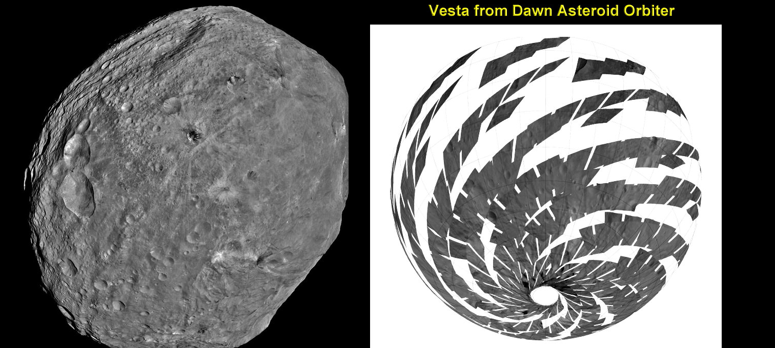
Vesta imaged by NASA’s Dawn Asteroid Orbiter. Dawn is currently at work at the Low Altitude Mapping Orbit (LAMO) acquiring new imagery and spectra of much higher resolution compared to these images acquired at higher altitudes and is also filling in gaps of surface data. The image from Dawn’s Framing Camera, at left, was taken on July 24 at a distance of 3,200 miles soon after achieving orbit around Vesta. The mosaic from Dawn’s Visible and infrared spectrometer (VIR), at right, was acquired from High-altitude mapping orbit (HAMO). Credit: NASA/ JPL-Caltech/ UCLA/ ASI/ INAF/ IAPS. Collage: Ken Kremer
[/caption]
NASA’s Dawn mission is getting a whopping boost in science observing time at the closest orbit around Asteroid Vesta as the probe passes the midway point of its 1 year long survey of the colossal space rock. And the team informs Universe Today that the data so far have surpassed all expectations and they are very excited !
Dawn’s bonus study time amounts to an additional 40 days circling Vesta at the highest resolution altitude for scientific measurements. That translates to a more than 50 percent increase beyond the originally planned length of 70 days at what is dubbed the Low Altitude Mapping Orbit, or LAMO.
“We are truly thrilled to be able to spend more time observing Vesta from low altitude,” Dr. Marc Rayman told Universe Today in an exclusive interview. Rayman is Dawn’s Engineer at NASA’s Jet Propulsion Laboratory (JPL) in Pasadena, Calif.
“It is very exciting indeed to obtain such a close-up look at a world that even a year ago was still just a fuzzy blob.”
The big extension for a once-in-a-lifetime shot at up close science was all enabled owing to the hard work of the international science team in diligently handling any anomalies along the pathway through interplanetary space and since Dawn achieved orbit in July 2011, as well as to the innovative engineering of the spacecraft’s design and its revolutionary ion propulsion system.
“This is a reflection of how well all of our work at Vesta has gone from the beginning of the approach phase in May 2011,” Rayman told me.
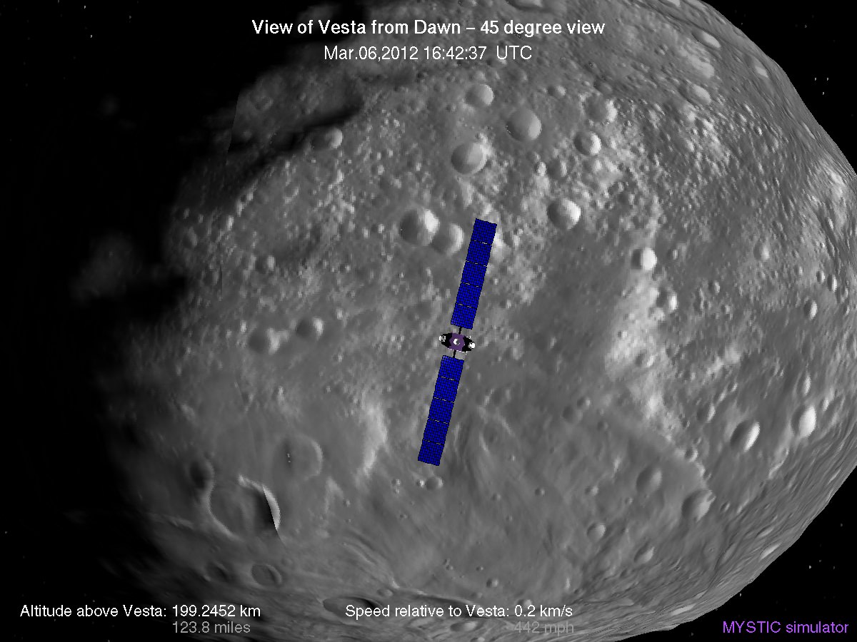
Simulated view of Vesta from Dawn in LAMO, low altitude mapping orbit - March, 6 2012
Credit: Gregory J. Whiffen, JPL
Dawn’s initially projected 10 week long science campaign at LAMO began on Dec. 12, 2011 at an average distance of 210 kilometers (130 miles) from the protoplanet and was expected to conclude on Feb. 20, 2012 under the original timeline. Thereafter it would start spiraling back out to the High Altitude Mapping Orbit, known as HAMO, approximately 680 kilometers above the surface.
“With the additional 40 days it means we are now scheduled to leave LAMO on April 4. That’s when we begin ion thrusting for the transfer to HAMO2,” Rayman stated.
And the observations to date at LAMO have already vastly surpassed all hopes – using all three of the onboard science instruments provided by the US, Germany and Italy.
“Dawn’s productivity certainly is exceeding what we had expected,” exclaimed Rayman.
“We have acquired more than 7500 LAMO pictures from the Framing Camera and more than 1 million LAMO VIR (Visible and Infrared) spectra which afford scientists a much more detailed view of Vesta than had been planned with the survey orbit and the high altitude mapping orbit (HAMO). It would have been really neat just to have acquired even only a few of these close-up observations, but we have a great bounty!”
“Roughly around half of Vesta’s surface has been imaged at LAMO.”
Dawn mosaic of Visible and Infrared spectrometer (VIR) data of Vesta
This mosaic shows the location of the data acquired by VIR (visible and infrared spectrometer) during the HAMO (high-altitude mapping orbit) phase of the Dawn mission from August to October 2011. Dawn is now making the same observations at the now extended LAMO (low-altitude mapping orbit) phase of the Dawn mission from December 2011 to April 2012. VIR can image Vesta in a number of different wavelengths of light, ranging from the visible to the infrared part of the electromagnetic spectrum. This mosaic shows the images taken at a wavelength of 550 nanometers, which is in the visible part of the electromagnetic spectrum. During HAMO VIR obtained more than 4.6 million spectra of Vesta. It is clear from this image that the VIR observations are widely distributed across Vesta, which results in a global view of the spectral properties of Vesta’s surface. This image shows Vesta’s southern hemisphere (lower part of the image) and equatorial regions (upper part of the image). NASA’s Dawn spacecraft obtained these VIR images with its visible and infrared spectrometer in September and October 2011. The distance to the surface of Vesta is around 700 kilometers (435 miles) and the average image resolution is 170 meters per pixel. Credit: NASA/ JPL-Caltech/ UCLA/ ASI/ INAF/ IAPS
The bonus time at LAMO will now be effectively used to help fill in the gaps in surface coverage utilizing all 3 science instruments. Therefore perhaps an additional 20% to 25% extra territory will be imaged at the highest possible resolution. Some of this will surely amount to enlarged new coverage and some will be overlapping with prior terrain, which also has enormous research benefits.
“There is real value even in seeing the same part of the surface multiple times, because the illumination may be different. In addition, it helps for building up stereo,” said Rayman.
Researchers will deduce further critical facts about Vesta’s topography, composition, interior, gravity and geologic features with the supplemental measurements.
Successive formation of impact craters on Vesta
This Dawn FC (framing camera) image shows two overlapping impact craters and was taken on Dec. 18,2011 during the LAMO (low-altitude mapping orbit) phase of the mission. The large crater is roughly 20 kilometers (12 miles) in diameter and the smaller crater is roughly 6 kilometers (4 miles) in diameter. The rims of the craters are both reasonably fresh but the larger crater must be older because the smaller crater cuts across the larger crater’s rim. As the smaller crater formed it destroyed a part of the rim of the pre-existing, larger crater. The larger crater’s interior is more densely cratered than the smaller crater, which also suggests that is it older. In the bottom of the image there is some material slumping from rim of the larger crater towards its center. This image with its framing camera on Dec. 18, 2011. This image was taken through the camera’s clear filter. The distance to the surface of Vesta is 260 kilometers (162 miles) and the image has a resolution of about 22 meters (82 feet) per pixel. Credit: NASA/ JPL-Caltech/ UCLA/ MPS/ DLR/ IDA
The foremost science goals at LAMO are collection of gamma ray and neutron measurements with the GRaND instrument – which focuses on determining the elemental abundances of Vesta – and collection of information about the structure of the gravitational field. Since GRaND can only operate effectively at low orbit, the extended duration at LAMO takes on further significance.
“Our focus is on acquiring the highest priority science. The pointing of the spacecraft is determined by our primary scientific objectives of collecting GRaND and gravity measurements.”
As Dawn continues orbiting every 4.3 hours around Vesta during LAMO, GRaND is recording measurements of the subatomic particles that emanate from the surface as a result of the continuous bombardment of cosmic rays and reveals the signatures of the elements down to a depth of about 1 meter.
“You can think of GRaND as taking a picture of Vesta but in extremely faint light. That is, the nuclear emissions it detects are extremely weak. So our long time in LAMO is devoted to making a very, very long exposure, albeit in gamma rays and neutrons and not in visible light,” explained Rayman.
Now with the prolonged mission at LAMO the team can gather even more data, amounting to thousands and thousands more pictures, hundreds of thousands of more VIR spectra and ultra long exposures by GRaND.
“HAMO investigations have already produced global coverage of Vesta’s gravity field,” said Sami Asmar, a Dawn co-investigator from JPL. Extended investigations at LAMO will likewise vastly improve the results from the gravity experiment.
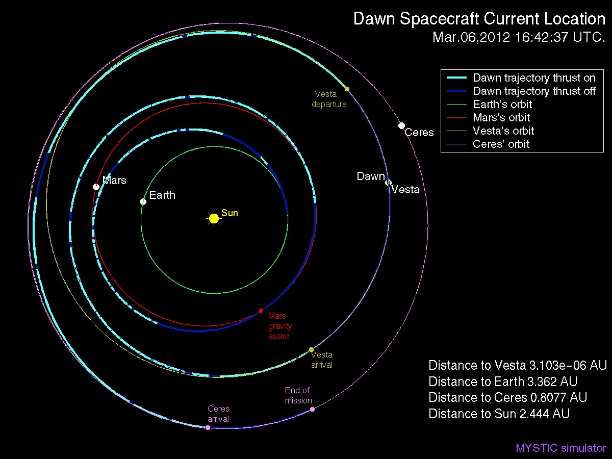
Dawn Spacecraft Current Location and Trajectory - March, 6 2012. Credit: Gregory J. Whiffen, JPL
“We always carried 40 days of “margin,” said Rayman, “but no one who was knowledgeable about the myriad challenges of exploring this uncharted world expected we would be able to accomplish all the complicated activities before LAMO without needing to consume some of that margin. So although we recognized that we might get to spend some additional time in LAMO, we certainly did not anticipate it would be so much.”
“As it turned out, although we did have surprises the operations team managed to recover from all of them without using any of those 40 days.”
“This is a wonderful bonus for science,” Rayman concluded.
“We remain on schedule to depart Vesta in July 2012, as planned for the past several years.”
Dawn’s next target is Ceres, the largest asteroid in the main Asteroid Belt between Mars and Jupiter
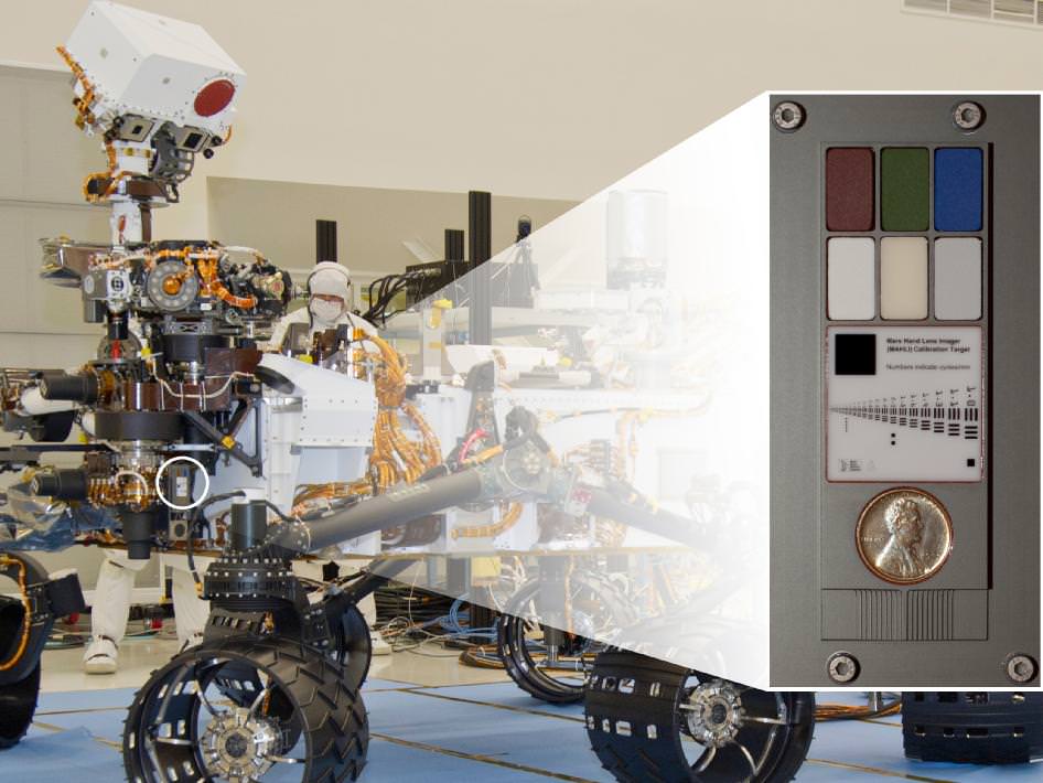
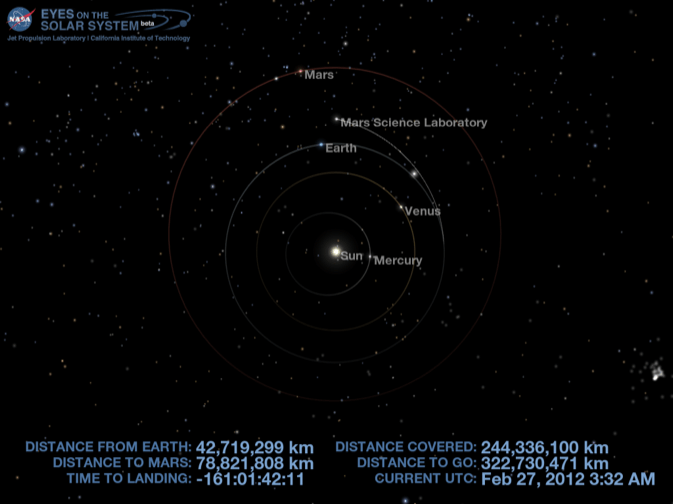
NASA's Mars rover Curiosity carries a Lincoln Penny on the calibration target to be used by a camera at the end of the robotic arm. The calibration target for the Mars Hand Lens Imager (MAHLI) camera is attached to a shoulder joint of the arm. Inset shows the location of the calibration target. Credit: NASA/JPL-Caltech
[/caption]
NASA’s huge Curiosity Mars Science Lab (MSL) rover is carrying a vintage Lincoln penny along for the long interplanetary journey to Mars – and it’s not to open the first Martian savings account.
Scientists will use the century old Lincoln penny – minted back in 1909 – as a modern age calibration target for one of Curiosity’s five powerful science cameras attached to the end of the hefty, 7 foot (2.1 meter) long robotic arm.
The car sized rover is on course to touchdown at the foothills of a towering and layered mountain inside Gale Crater in just 161 days on Aug. 6, 2012.
So far Curiosity has traveled 244 million kilometers since blasting off on Nov. 26, 2011 from Florida and has another 322 million kilometers to go to the Red Planet.
The copper penny is bundled to a shoulder joint on the rovers arm along with the other elements of the calibration target, including color chips, a metric standardized bar graphic, and a stair-step pattern for depth calibration.
The whole target is about the size of a smart phone and looks a lot like an eye vision chart in an ophthalmologist’s office. And it serves a similar purpose, which will be to check the performance of Curiosity eyes – specifically the Mars Hand Lens Imager (MAHLI) camera located at the terminus of the robotic arm.
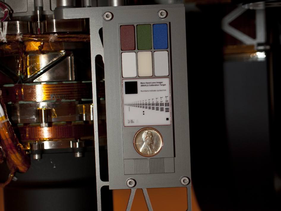
Curiosity’s Calibration Target
Two instruments at the end of the robotic arm on NASA's Mars rover Curiosity will use calibration targets attached to a shoulder joint of the arm. Credit: NASA/JPL-Caltech
MAHLI will conduct close-up inspections of Martian rocks and soil. It can show tiny details, finer than a human hair.
The term “hand lens” in MAHLI’s name refers to the standard practice by field geologists’ of carrying a hand lens during expeditions for close up, magnified inspection of rocks they find along the way. So it’s also critical to pack various means of calibration so that researchers can interpret their results and put them into proper perspective.
MAHLI can also focus on targets over a wide range of distances near and far, from about a finger’s-width away out to the Red Planets horizon, which in this case means the mountains and rim of the breathtaking Gale Crater landing site.
“When a geologist takes pictures of rock outcrops she is studying, she wants an object of known scale in the photographs,” said MAHLI Principal Investigator Ken Edgett, of Malin Space Science Systems, San Diego, which supplied the camera to NASA.
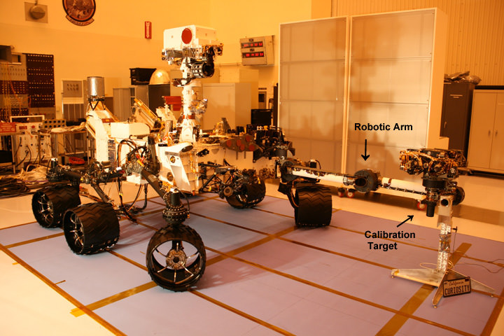
Curiosity Mars Science Laboratory Rover - inside the Cleanroom at KSC
Curiosity with robotic arm extended. Calibration target is located at a shoulder joint on the arm. Photo taken just before encapsulation for 8 month long interplanetary Martian Journey and touchdown inside Gale Crater. Credit: Ken Kremer
The target features a collection of marked black bars in a wide range of labeled sizes to correlate calibration images to each image taken by Curiosity.
“If it is a whole cliff face, she’ll ask a person to stand in the shot. If it is a view from a meter or so away, she might use a rock hammer. If it is a close-up, as the MAHLI can take, she might pull something small out of her pocket. Like a penny.”
Edgett donated the special Lincoln penny with funds from his own pocket. The 1909 “VDB” cent stems from the very first year that Lincoln pennies were minted and also marks the centennial of President Abraham Lincoln’s birth. The VDB initials of the coin’s designer – Victor David Brenner — are on the reverse side. In mint condition the 1909 Lincoln VDB copper penny has a value of about $20.
The Lincoln penny in this photograph is part of a camera calibration target attached to NASA's Mars rover Curiosity. Credit: NASA/JPL-Caltech
“The penny is on the MAHLI calibration target as a tip of the hat to geologists’ informal practice of placing a coin or other object of known scale in their photographs. A more formal practice is to use an object with scale marked in millimeters, centimeters or meters,” Edgett said. “Of course, this penny can’t be moved around and placed in MAHLI images; it stays affixed to the rover.”
“Everyone in the United States can recognize the penny and immediately know how big it is, and can compare that with the rover hardware and Mars materials in the same image,” Edgett said.
“The public can watch for changes in the penny over the long term on Mars. Will it change color? Will it corrode? Will it get pitted by windblown sand?”
MAHLI’s calibration target also features a display of six patches of pigmented silicone to assist in interpreting color and brightness in the images. Five of them are leftovers from Spirit and Opportunity. The sixth has a fluorescent pigment that glows red when exposed to ultraviolet light, allows checking of an ultraviolet light source on MAHLI. The fluorescent material was donated to the MAHLI team by Spectra Systems, Inc., Providence, R.I.
Three-dimensional calibration of the MSL images will be done using the penny and a stair-stepped area at the bottom of the target.
“The importance of calibration is to allow data acquired on Mars to be compared reliably to data acquired on Earth,” said Mars Science Laboratory Project Scientist John Grotzinger, of the California Institute of Technology, Pasadena.
Curiosity is a 1 ton (900 kg) behemoth. She measures 3 meters (10 ft) in length and is nearly twice the size and five times as heavy as Spirit and Opportunity, NASA’s prior set of twin Martian robots. The science payload is 15 times heavier than the twin robots.
Curiosity is packed to the gills with 10 state of the art science instruments that are seeking the signs of life in the form of organic molecules – the carbon based building blocks of life as we know it.
NASA could only afford to build one rover this time.
Curiosity MSL location on 27 Feb 2012. Credit: NASA
Curiosity will be NASA’s last Mars rover since the 4th generation ExoMars rover due to liftoff in 2018 was just cancelled by the Obama Administration as part of a deep slash to NASA’s Planetary Science budget.
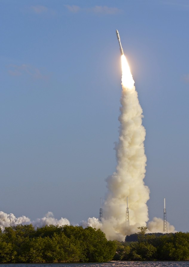
Feb. 24, 2012 launch of Atlas V with MUOS-1. Credit: Jen Scheer (@flyingjenny)
[/caption]
On the afternoon of February 24, 2012, at 5:15 p.m. EST local time, a United Launch Alliance Atlas V rocket lifted off from the pad at Cape Canaveral Air Force Base carrying in its payload the US Navy’s next-generation narrowband communications satellite MUOS-1. After two scrubbed launches the previous week due to weather, the third time was definitely a charm for ULA, and the launch went nominally (that’s science talk for “awesome”.)
But what made that day, that time the right time to launch? Do they just like ending a work week with a rocket launch? (Not that I could blame them!) And what about the weather… why go through the trouble to prepare for a launch at all if the weather doesn’t look promising? Where’s the logic in that?
As it turns out, when it comes to launches, it really is rocket science.
There are a lot of factors involved with launches. Obviously all the incredible engineering it takes to even plan and build a launch vehicle, and of course its payload — whatever it happens to be launching in the first place. But it sure doesn’t end there.
Launch managers need to take into consideration the needs of the mission, where the payload has to ultimately end up in orbit… or possibly even beyond. Timing is critical when you’re aiming at moving targets — in this case the targets being specific points in space (literally.) Then there’s the type of rocket being used, and where it is launching from. Only then can weather come into the equation, and usually only at the last minute to determine if the countdown will proceed before the launch window closes.
How big that launch window may be — from a few hours to a few minutes — depends on many things.
Kennedy Space Center’s Anna Helney recently assembled an article “Aiming for an Open Window” that explains how this process works:
_________________
The most significant deciding factors in when to launch are where the spacecraft is headed, and what its solar needs are. Earth-observing spacecraft, for example, may be sent into low-Earth orbit. Some payloads must arrive at a specific point at a precise time, perhaps to rendezvous with another object or join a constellation of satellites already in place. Missions to the moon or a planet involve aiming for a moving object a long distance away.
For example, NASA’s Mars Science Laboratory spacecraft began its eight-month journey to the Red Planet on Nov. 26, 2011 with a launch aboard a United Launch Alliance (ULA) Atlas V rocket from Cape Canaveral Air Force Station in Florida. After the initial push from the powerful Atlas V booster, the Centaur upper stage then sent the spacecraft away from Earth on a specific track to place the laboratory, with its car-sized Curiosity rover, inside Mars’ Gale Crater on Aug. 6, 2012. Due to the location of Mars relative to Earth, the prime planetary launch opportunity for the Red Planet occurs only once every 26 months.
Additionally, spacecraft often have solar requirements: they may need sunlight to perform the science necessary to meet the mission’s objectives, or they may need to avoid the sun’s light in order to look deeper into the dark, distant reaches of space.
A Delta II arcs across the sky carrying NASA's Suomi NPP spacecraft. Image credit: NASA/Bill Ingalls
Such precision was needed for NASA’s Suomi National Polar-orbiting Partnership (NPP) spacecraft, which launched Oct. 28, 2011 aboard a ULA Delta II rocket from Vandenberg Air Force Base in California. The Earth-observing satellite circles at an altitude of 512 miles, sweeping from pole to pole 14 times each day as the planet turns on its axis. A very limited launch window was required so that the spacecraft would cross the ascending node at exactly 1:30 p.m. local time and scan Earth’s surface twice each day, always at the same local time.
All of these variables influence a flight’s trajectory and launch time. A low-Earth mission with specific timing needs must lift off at the right time to slip into the same orbit as its target; a planetary mission typically has to launch when the trajectory will take it away from Earth and out on the correct course.
According to [Eric Haddox, the lead flight design engineer in NASA’s Launch Services Program], aiming for a specific target — another planet, a rendezvous point, or even a specific location in Earth orbit where the solar conditions will be just right — is a bit like skeet shooting.
“You’ve got this object that’s going to go flying out into the air and you’ve got to shoot it,” said Haddox. “You have to be able to judge how far away your target is and how fast it’s moving, and make sure you reach the same point at the same time.”
But Haddox also emphasized that Earth is rotating on its axis while it orbits the sun, making the launch pad a moving platform. With so many moving players, launch windows and trajectories must be carefully choreographed.
__________________
It’s a fascinating and complex set of issues that mission managers need to get just right in order to ensure the success of a launch — and thus the success of a mission, whether it be putting a communication satellite into orbit or a rover onto Mars… or somewhere much, much farther than that.
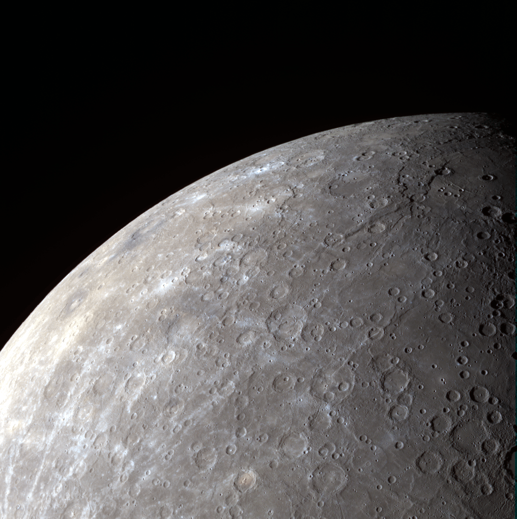
MESSENGER wide-angle camera image of Mercury's southern hemisphere.
[/caption]
NASA’s MESSENGER spacecraft, about to wrap up its first full year in orbit around Mercury, captured this view of the planet’s heavily-cratered southern hemisphere on August 28, 2011. Because of its orbit, MESSENGER gets particularly good panoramic views of Mercury’s underside.
Here’s why…
MESSENGER’s orbit, established on March 18, 2011 at 00:45 UTC, is not a simple circling path around the first rock from the Sun. Instead it is highly elliptical, bringing it 124 miles (200 km) above Mercury’s north pole at its closest and more than 9,420 miles (15,193 km) from its south pole at its farthest! (See diagram below.)
The close approaches over the northern hemisphere allow MESSENGER to study the Caloris basin, Mercury’s largest surface feature and, at over 960 miles (1,550 km) across, one of the largest impact craters in the entire Solar System.
The view of Mercury’s southern hemisphere above features some notable craters as well: the relatively youthful 444-mile (715-km) -wide Rembrandt basin is seen at top right, while the smaller pit-floor crater Kipling can be discerned to its left, just below the planet’s limb.
When craters are larger than 300 km in diameter, they are referred to as basins.
During its 12 months in orbit MESSENGER will have experienced only two days on Mercury! This is because Mercury rotates very slowly on its axis, completing a full solar day (sunrise to sunrise) every 176 Earth days. (And you thought your work day seemed to last forever!)
Tendrils of ice particles, called frazil, extend out into Antarctica's Mackenzie Bay. (NASA/EO-1 - ALI)
[/caption]
Ghostly green tendrils drift out into Mackenzie Bay off the coast of eastern Antarctica in this image, acquired by NASA’s Earth-Observing (EO-1) satellite on Feb. 12, 2012.
The tendrils are made of fine particles of ice called frazil, the result of upwelling cold water from deep beneath the Amery ice shelf.
Sea water flowing in currents under the Amery ice shelf gets cooled to temperatures below freezing, the result of greater water pressures existing at depth. As some of the water rises and flows along the underside of the shelf toward the open ocean, it gradually encounters less pressure since the ice thickness decreases the further away from shore it extends.
When the supercold water approaches the surface where pressure is lowest, it instantly freezes, forming needle-like ice particles called frazil.
Only 3 -4 millimeters wide, the frazil crystals can still be concentrated enough to be visible from orbit as it drifts into the bay, flowing around icebergs as it is carried along by wind and currents. (The largest iceberg in the image is a little over 4 km/2.5 miles long.)
Eventually the warmer surface water that surrounds the southern continent melts the frazil, and the tendrils fade away.
Scheduled to fly for a year and only designed to last a year and a half, EO-1 celebrated its eleventh anniversary on November 21, 2011. During its time in orbit the satellite has accomplished far more than anyone dreamed, and its Earth-observing mission continues on. Read more on the EO-1 site here.
Clouds over the southern Indian Ocean, July 23, 2007. (NASA/JPL-Caltech)
[/caption]
Ok, maybe not the sky itself… but the clouds. According to recent research by climate scientists in New Zealand, global cloud heights have dropped.
Researchers at The University of Auckland have reported a decreasing trend in average global cloud heights from 2000 to 2010, based on data gathered by the Multi-angle Imaging SpectroRadiometer (MISR) on NASA’s Terra satellite. The change over the ten-year span was 30 to 40 meters (about 100 to 130 feet), and was mostly due to fewer clouds at higher altitudes.
It’s suspected that this may be indicative of some sort of atmospheric cooling mechanism in play that could help counteract global warming.
“This is the first time we have been able to accurately measure changes in global cloud height and, while the record is too short to be definitive, it provides just a hint that something quite important might be going on,” said lead researcher Professor Roger Davies.
A steady reduction in cloud heights could help the planet radiate heat into space, thus serving as a negative feedback in the global warming process. The exact cause of the drop in cloud altitude is not yet known, but it could reasonably be resulting from a change in circulation patterns that otherwise form high-altitude clouds.
Rendering of the Terra spacecraft. (NASA)
Cloud heights are just one of the many factors that affect climate, and until now have not been able to be measured globally over a long span of time.
“Clouds are one of the biggest uncertainties in our ability to predict future climate,” said Davies. “Cloud height is extremely difficult to model and therefore hasn’t been considered in models of future climate. For the first time we have been able to accurately measure the height of clouds on a global basis, and the challenge now will be to incorporate that information into climate models. It will provide a check on how well the models are doing, and may ultimately lead to better ones.”
While Terra data showed yearly variations in global cloud heights, the most extreme caused by El Niño and La Niña events in the Pacific, the overall trend for the years measured was a decrease.
Continuing research will be needed to determine future trends and how they may impact warming.
“If cloud heights come back up in the next ten years we would conclude that they are not slowing climate change,” Davies said. “But if they keep coming down it will be very significant.”
The team’s study was recently published in the journal Geophysical Research Letters.
Terra is a multi-national, multi-disciplinary mission involving partnerships with the aerospace agencies of Canada and Japan. An important part of NASA’s Science Mission, Terra is helping scientists around the world better understand and protect our home planet.
Vesta's surface textures get highlighted by dawn's light
[/caption]
Sunrise on Vesta highlights the asteroid’s varied surface textures in this image from NASA’s Dawn spacecraft, released on Monday, Feb. 20. The image was taken on Dec. 18 with Dawn’s Framing Camera (FC).
Just as the low angle of early morning sunlight casts long shadows on Earth, sunrise on Vesta has the same effect — although on Vesta it’s not trees and buildings that are being illuminated but rather deep craters and chains of pits!
The steep inner wall of a crater is seen at lower right with several landslides visible, its outer ridge cutting a sharp line.
Chains of pits are visible in the center of the view. These features are the result of ejected material from an impact that occurred outside of the image area.
Other lower-profile, likely older craters remain in shadow.
Many of these features would appear much less dramatic with a high angle of illumination, but they really shine brightest in dawn’s light.
Mosaic: NASA/JPL/Cornell/ASU/Marco Di Lorenzo/Kenneth Kremer
[/caption]
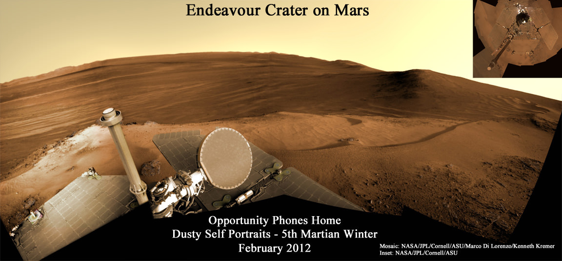
Opportunity, the Princess of Martian Robots, phoned home dusty new self portraits – above and below – of her beautiful bod basking in the utterly frigid sunshine during her 5th winter on the Red Planet whilst overlooking a humongous crater offering bountiful science.
NASA’s endearing robot is simultaneously carrying out an ambitious array of ground breaking science experiments this winter – providing insight into the mysterious nature of the Martian core – while sitting stationary until the energy augmenting rays of the springtime Sun shower down on Mars from the heavens above.
Opportunity’s current winter worksite is located at the rim of the vast crater named Endeavour, some 14 miles (22 kilometers) in diameter. The robot will remain parked for the winter on a slope at the north end of the crater rim segment called Cape York with an approximate 15-degree northerly tilt towards the life-giving sun to maximize solar energy production. The park-site is at an outcrop dubbed “Greeley Haven”, named in honor of Ronald Greeley, a beloved and recently deceased science team member.
The power killing dust buildup is readily apparent on the solar arrays and High Gain Antenna pictured in the new panoramic self-portraits of Opportunity’s wing-like deck. The red Martian dust also functions as a rather effective camouflage agent, sometimes blending the rover to near invisibility with the surface.
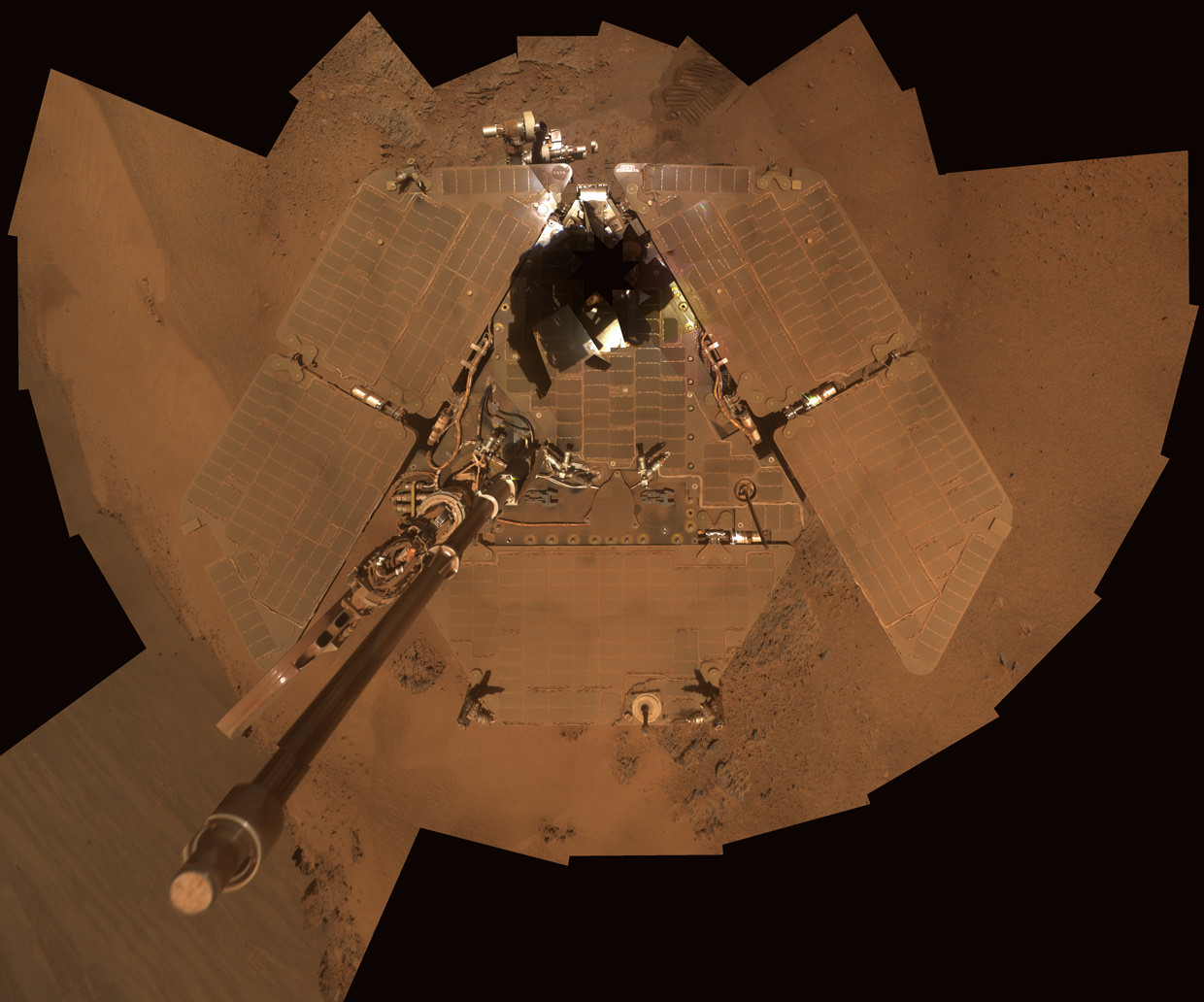
Dusty Mars Rover's Self-Portrait- Dec 2011
NASA's Mars Exploration Rover Opportunity shows dust accumulation on the rover's solar panels as the mission approached its fifth Martian winter at the rim of Endeavour Crater. Opportunity is located on the north-facing slope of a site called "Greeley Haven." This is a mosaic of images taken by Opportunity's panoramic camera (Pancam) during the 2,811th to 2,814th Martian days, or sols, of the rover's mission (Dec. 21 to Dec. 24, 2011). Credit: NASA/JPL-Caltech/Cornell/Arizona State Univ.
Indeed because Opportunity is covered with a thicker film of dust compared to her prior four Martian winters, the rover team was forced to employ the same “tilting” strategy they successfully used to keep her twin sister Spirit alive during her trio of Antarctic-like winters. This is the first winter that Opportunity did not have sufficient power to continue roving across the surface.
Since Opportunity is located just south of the Martian equator, the daylight hours for solar power generation are growing shorter until the southern Mars winter solstice occurs on March 30, 2012. As of mid- February 2012, the latest measure of solar array energy production was 274 watt-hours, compared to about 900 watt-hours at the start of the mission. See Solar Power energy graph below.
Power generation from the solar arrays has fluctuated up and down throughout Opportunity’s lifetime depending on when the completely unpredictable and fortuitous Martian wind storms chance by and miraculously clean the arrays of the rusty red dust.
Opportunity Rover Self-Portrait From 2007
Opportunity used its panoramic camera (Pancam) during the mission's sols 1282 and 1284 (Sept. 2 and Sept. 4, 2007) to take the images combined into this mosaic view of the rover. The downward-looking view omits the mast on which the camera is mounted.The deck panorama is presented in approximate true color, the camera team's best estimate of what the scene would look like if humans were there and able to see it with their own eyes.Credit: NASA/JPL-Caltech/Cornell
The rover science team is ingeniously using the lack of movement to their advantage and Opportunity is still vigorously hard at work doing breakthrough research each and every day.
From her stationary position, Opportunity is conducting her first ever radio science Doppler tracking measurements to support geo-dynamic investigations and to elucidate the unknown structure of the Martian interior and core. The team was eager for the long awaited chance to carry out the radio tracking experiment with the High Gain Antenna (HGA) and determine if Mars core is liquid or solid. Months of data collection are required while the rover stays stationary.
“This winter science campaign will feature two way radio tracking with Earth to determine the Martian spin axis dynamics – thus the interior structure, a long-neglected aspect of Mars,” Ray Arvidson told Universe Today. Arvidson, of Washington University in St. Louis, is the deputy rover Principal Investigator.
Opportunity has nearly finished snapping the 13 filter, 360 degree stereo Greeley” panorama. The rover deployed the robotic arm onto the surface of the “Amboy” outcrop to collect multi-sol integrations with the Mössbauer Spectrometer and the largest ever mosaic campaign using the Microscopic Imager.
“We’ll do good science while we’re at Greeley Haven. But as soon as we catch a wind gust or the seasons change, we’ll be on our way again,” Steve Squyres told Universe Today. Squyres, of Cornell University is the rover Science Principal Investigator
“The Martian southern winter solstice occurs at the end of March. A few months after that date we will drive her off the outcrop and further explore Cape York,” Arvidson told me
The team will drive Opportunity in search of further evidence of the gypsum mineral veins like “Homestake” – indicative of ancient water flow – previously discovered at Cape York. Thereafter they’ll rove further south to investigate deposits of phyllosilicates, the clay minerals which stem from an earlier epoch when liquid water flowed on Mars eons ago and perhaps may have been more favorable to sustaining life.
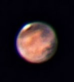
Graph shows Opportunity’s Solar power energy generation over the past 1000 Sols, or Martian Days, from Sol 1900 up to February 2012. Credit: NASA/JPL/Marco Di Lorenzo Mars from Earth on Feb 18, 2012 is nearly at opposition (occurs March 3) in this image taken using a Celestron 11 inch telescope in Leesburg, Florida. Astrophotographer Credit: Ernie Rossi
Opportunity is now well into her 9th year exploring hitherto unknown terrain on Mars, far exceeding anyone’s expectation. She landed inside a tiny crater on Jan. 24. 2004 for what was expected to be a mission of merely 90 Martian days, or Sols.
Today is Martian Sol 2873, that’s 32 times beyond the rover designers “warranty” for NASA’s Opportunity rover.
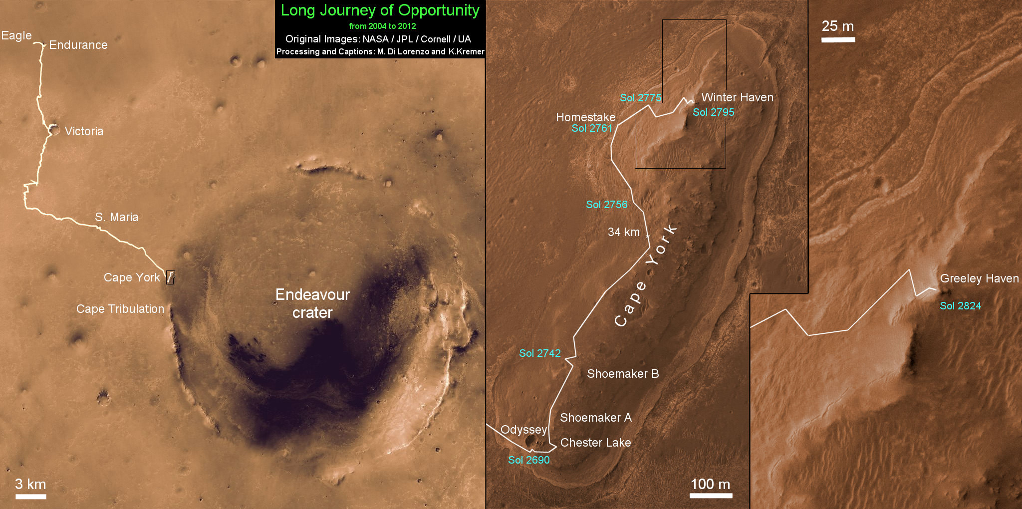
Altogether, Opportunity has journeyed more than 21 miles (34 kilometers) across the Red Planet’s surface, marking the first overland expedition on another Planet. See our route map below.
Opportunity Rover Traverse Map at Meridiani Planum on Mars - 2004 to 2012
Traverse map shows the 8 Year Journey of Opportunity from Eagle Crater landing site on Sol 1- Jan. 24, 2004 - to 5th Winter Haven worksite at Greeley Haven at Endeavour Crater rim in January 2012. Opportunity embarked on a crater tour and discovered bountiful evidence for the flow of liquid water on Mars billions of years ago. Endeavour Crater is 14 miles 22 kilometers) in diameter. Opportunity has driven more than 21 miles (34 km). Credit: NASA/JPL/Cornell/UA/Marco Di Lorenzo/Kenneth Kremer
Meanwhile, NASA’s Curiosity Mars Science Laboratory rover is rocketing through space and on course for a pinpoint touchdown inside the layered terrain of Gale Crater on August 6, 2012. Curiosity is now America’s last planned Mars rover following the cancellation of the joint NASA/ESA ExoMars rover mission in the Obama Administrations newly announced Fiscal 2013 NASA budget.
This image, acquired by NASA’s MESSENGER spacecraft on December 12, 2011, reveals the blue coloration of the 32-mile (52-km) -wide Degas crater located in Mercury’s Sobkou Planitia region.
Degas’ bright central peaks are highly reflective in this view, and may be surrounded by hollows — patches of sunken, eroded ground first identified by MESSENGER last year.
Such blue-colored material within craters has been increasingly identified as more of Mercury’s surface is revealed in detail by MESSENGER images. It is likely due to an as-yet-unspecified type of dark subsurface rock, revealed by impact events.
The slightly larger, more eroded crater that Degas abuts is named Brontë.
The image was acquired with MESSENGER’s Wide Angle Camera (WAC) of the Mercury Dual Imaging System (MDIS), using filters 9, 7, 6 (996, 748, 433 nanometers) in red, green, and blue, respectively.
Image credit: NASA/Johns Hopkins University Applied Physics Laboratory/Carnegie Institution of Washington.