Powerful Private Rocket Crucial to ISS Set for Maiden April Blast Off from Virginia – Launch Pad Gallery

The first stage of the privately developed Antares rocket stands on the pad at NASA's Wallops Flight Facility. Credit: Ken Kremer (kenkremer.com)

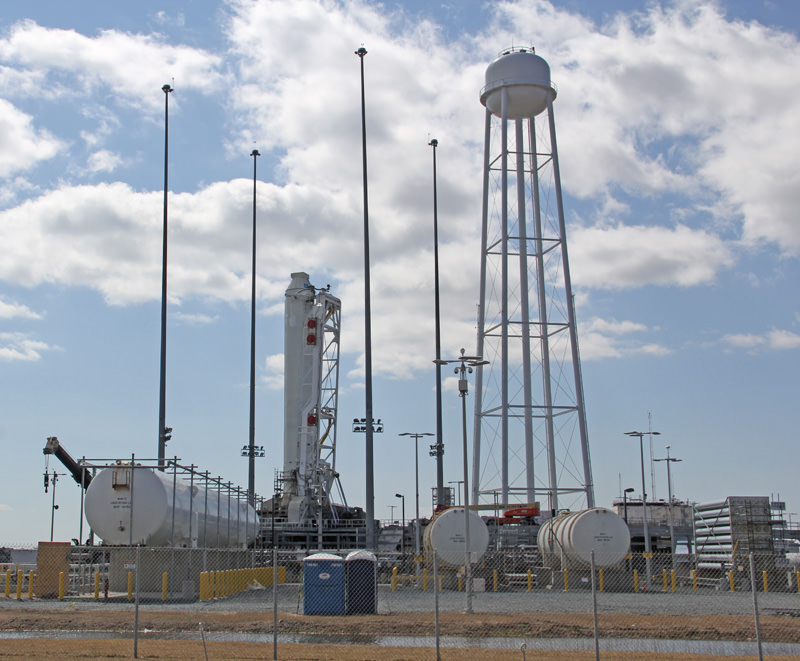
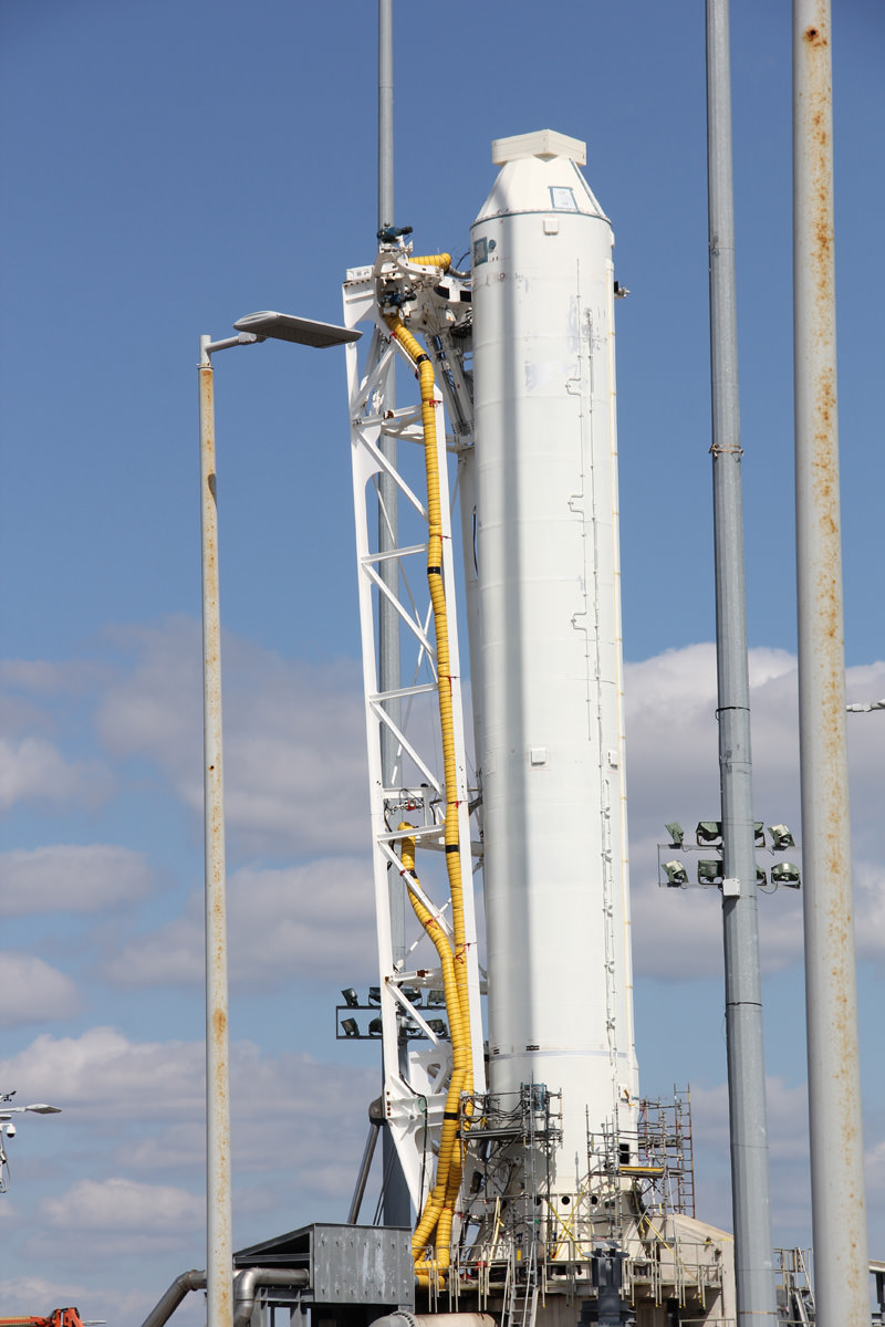
The first stage of the privately developed Antares rocket stands erect at newly constructed Launch Pad 0-A at NASA’s Wallops Flight Facility during exclusive launch complex tour by Universe Today. Maiden Antares test launch is scheduled for mid-April 2013. Later operational flights are critical to resupply the ISS.
Credit: Ken Kremer (kenkremer.com)
See Antares photo gallery below[/caption]

The most powerful rocket ever to ascend near major American East Coast population centers is slated to blast off soon from the eastern Virginia shore on its inaugural test flight in mid April.

And Universe Today took an exclusive inspection tour around the privately developed Antares rocket and NASA Wallops Island launch complex just days ago.

NASA announced that the maiden flight of the commercial Antares rocket from Orbital Sciences is slated to soar to space between April 16 to 18 from the newly constructed seaside launch pad dubbed 0-A at the Mid-Atlantic Regional Spaceport (MARS) at NASA’s Wallops Flight Facility in Virginia.

The two stage Antares rocket is absolutely pivotal to NASA’s plans to ship essential cargo to the International Space Station (ISS) in the wake of the shutdown of the Space Shuttle program in July 2011.

No admittance to the Orbital Sciences Corp. Antares rocket without permission from the pad manager! Credit: Ken Kremer (kenkremer.com)
No admittance to the Orbital Sciences Corp. Antares rocket without permission from the pad manager. Credit: Ken Kremer (kenkremer.com)

Antares stands 131 feet tall and serves as the launcher for the unmanned commercial Cygnus cargo spacecraft.

Both Antares and Cygnus were developed by Orbital Sciences Corp under NASA’s Commercial Orbital Transportation Services (COTS) program to replace the ISS cargo resupply capability previously tasked to NASA’s now retired Space Shuttle’s. The goal is to achieve safe, reliable and cost-effective transportation to and from the ISS and low-Earth orbit (LEO).

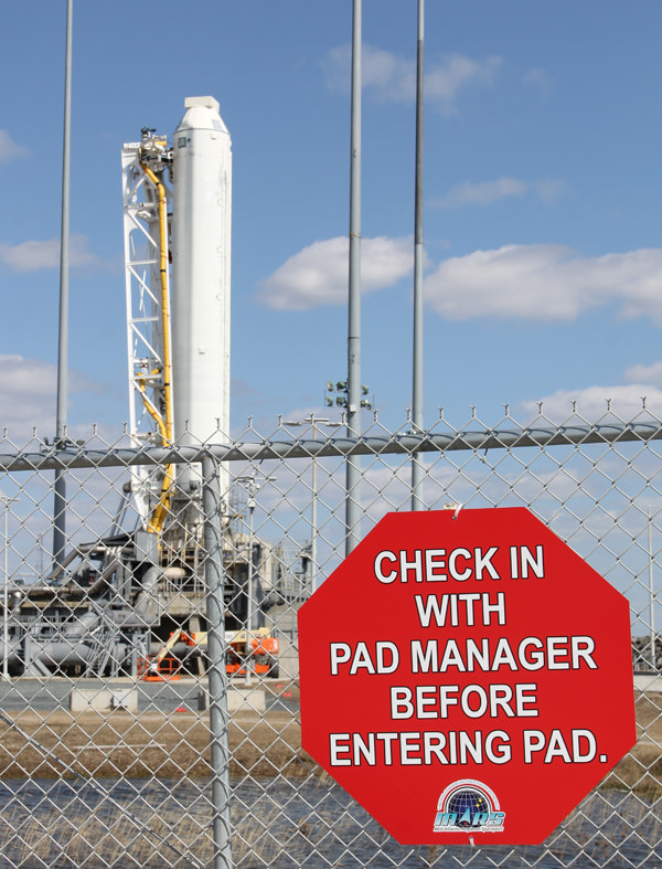
I visited NASA Wallops for an up close personal tour of the impressive Antares 1st stage rocket erected at the launch pad following the successful 29 second hot fire engine test that cleared the last hurdle to approve the maiden flight of Antares. Umbilical lines were still connected to the rocket.

Antares rocket 1st stage and umbilicals at NASA Wallops Flight Facility.  Credit: Ken Kremer (kenkremer.com)
Antares rocket 1st stage and umbilical lines at NASA Wallops Flight Facility. Credit: Ken Kremer (kenkremer.com)

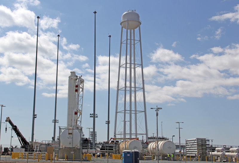
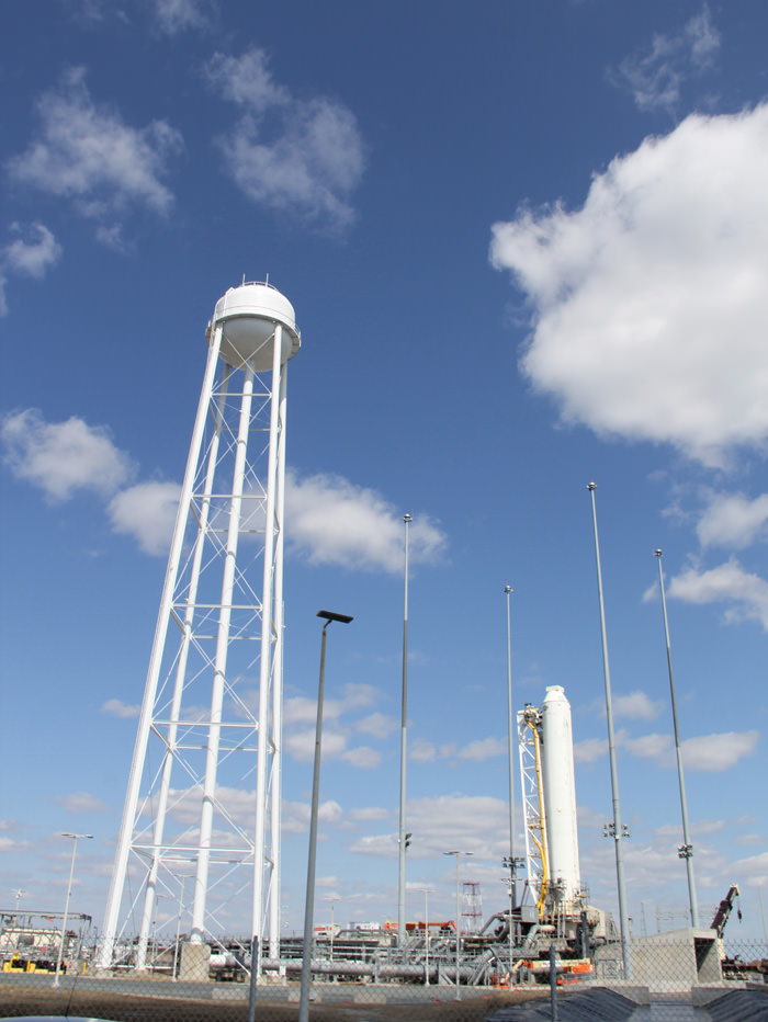
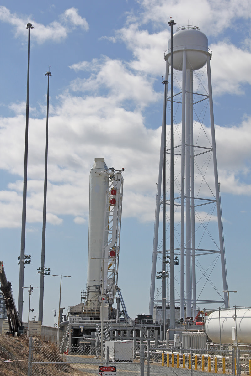
The pads protective seawall was rebuilt following significant damage from Hurricane Sandy, NASA Wallops spokesman Keith Koehler told me.

Launch Complex 0-A sits just a few hundred yards (meters) from Virginia’s eastern shore line on the Atlantic Ocean. It’s hard to believe just how close the low lying pad complex is to the beach and potentially destructive tidal surges.

Barely 400 meters (1300 feet) away lies the adjacent Launch Pad 0-B – from which Orbital’s new and unflown solid fueled Minotaur 5 rocket will boost NASA’s LADEE lunar science probe to the Moon in August 2013 – see my upcoming article.

The maiden Antares test flight is called the A-One Test Launch Mission. It will validate the medium class rocket for the actual follow-on flights to the ISS topped with the Cygnus cargo carrier starting later this year with a demonstration docking mission to the orbiting lab complex.

The first stage of the privately developed Antares rocket stands on the pad at NASA's Wallops Flight Facility. Credit: Ken Kremer (kenkremer.com)
1st stage of private Antares rocket erect at new Launch Pad 0-A at NASA’s Wallops Flight Facility. This rocket will be rolled back to the hanger to make way for the complete Antares booster due to blast off in mid-April 2013. Credit: Ken Kremer (kenkremer.com)

The Antares first stage is powered by dual liquid fueled AJ26 first stage rocket engines that generate a combined total thrust of some 680,000 lbs. The upper stage features a Castor 30 solid rocket motor with thrust vectoring. Antares can loft payloads weighing over 5000 kg to LEO.

The launch window opens at 3 p.m. and extends for a period of time since this initial test flight is not docking at the ISS, Orbital spokesman Barry Boneski told Universe Today.

Antares will boost a simulated version of the Cygnus carrier – known as a mass simulator – into a target orbit of 250 x 300 kilometers and inclined 51.6 degrees.

Antares A-One will fly on a southeast trajectory and the Cygnus dummy will be instrumented to collect flight and payload data.

The simulated Cygnus will separate from the upper stage 10 minutes after liftoff for orbital insertion.

“All launches are to the south away from population centers. Wildlife areas are nearby,” said Koehler.

The goal of the ambitious A-One mission is to fully demonstrate every aspect of the operational Antares rocket system starting from rollout of the rocket and all required functions of an operational pad from range operation to fueling to liftoff to payload delivery to orbit.

Orbital Sciences Antares rocket and Launch Complex 0-A at the edge of Virginia’s shore at NASA Wallops are crucial to resupply the International Space Station (ISS). Credit: Ken Kremer (kenkremer.com)
Orbital Sciences Antares rocket and Launch Complex 0-A at the edge of Virginia’s shore at NASA Wallops are crucial to resupply the International Space Station (ISS). . Credit: Ken Kremer (kenkremer.com)

Antares/Cygnus will provide a cargo up mass service similar to the Falcon 9/Dragon system developed by SpaceX Corporation – which has already docked three times to the ISS during historic linkups in 2012 and earlier this month following the tension filled March 1 liftoff of the SpaceX CRS-2 mission.

The Dragon is still docked to the ISS and is due to make a parachute assisted return to Earth on March 26.

The first stage of the privately developed Antares rocket stands on the pad at NASA's Wallops Flight Facility. Credit: Ken Kremer (kenkremer.com)
Antares rocket 1st stage and huge water tower at NASA’s Wallops Flight Facility. Credit: Ken Kremer (kenkremer.com)

Orbital has eight commercial resupply missions manifested under a $1.9 Billion contact with NASA to deliver approximately 20,000 kilograms of supplies and equipment to the ISS, Orbital spokesman Barry Boneski told me.

Tens of millions of American East Coast residents in the Mid-Atlantic and Northeast regions have never before had the opportunity to witness anything as powerful as an Antares rocket launch in their neighborhood.

Watch for my continuing reports through liftoff of the Antares A-One Test flight.

Ken Kremer

NASA Wallops Launch Control Center. Credit: Ken Kremer (kenkremer.com)
Ken Kremer & Antares rocket at NASA Wallops launch pad at the Virginia Eastern Shore.  Only a few hundred feet separate the pad from the Atlantic Ocean. Credit: Ken Kremer (kenkremer.com)
Ken Kremer & Antares rocket at NASA Wallops launch pad at the Virginia Eastern Shore. Only a few hundred feet of beach sand and a low sea wall separate the pad from the Atlantic Ocean and Mother Nature. Credit: Ken Kremer (kenkremer.com)

Sequester Cancels NASA Outreach


Well, it looks like it’s finally happened: the U.S. sequester — a “series of across-the-board cuts to government agencies totaling $1.2 trillion over 10 years” (CNN) — has finally hit NASA… right where it hurts, too: in public outreach and STEM programs. (UPDATE: some clarifications as to what this means — namely, that nothing’s actually been “canceled” but rather subject to review and possibly suspension — can be found at the end of this article. –JM)

In an internal memo issued on the evening of Friday, March 22, the Administration notes that “effective immediately, all education and public outreach activities should be suspended, pending further review. In terms of scope, this includes all public engagement and outreach events, programs, activities, and products developed and implemented by Headquarters, Mission Directorates, and Centers across the Agency, including all education and public outreach efforts conducted by programs and projects.”

Bummer.

Read the full memo from NASA Public Affairs below:

Subject: Guidance for Education and Public Outreach Activities Under Sequestration

As you know, we have taken the first steps in addressing the mandatory spending cuts called for in the Budget Control Act of 2011. The law mandates a series of indiscriminate and significant across-the-board spending reductions totaling $1.2 trillion over 10 years.

As a result, we are forced to implement a number of new cost-saving measures, policies, and reviews in order to minimize impacts to the mission-critical activities of the Agency. We have already provided new guidance regarding conferences, travel, and training that reflect the new fiscal reality in which we find ourselves. Some have asked for more specific guidance at it relates to public outreach and engagement activities. That guidance is provided below.

Effective immediately, all education and public outreach activities should be suspended, pending further review. In terms of scope, this includes all public engagement and outreach events, programs, activities, and products developed and implemented by Headquarters, Mission Directorates, and Centers across the Agency, including all education and public outreach efforts conducted by programs and projects.

The scope comprises activities intended to communicate, connect with, and engage a wide and diverse set of audiences to raise awareness and involvement in NASA, its goals, missions and programs, and to develop an appreciation for, exposure to, and involvement in STEM. Audiences include employees, partners, educators, students, and members of the general public. The scope encompasses, but is not limited to:

– Programs, events, and workshops.
– Permanent and traveling exhibits, signage, and other materials.
– Speeches, presentations, and appearances, with the exception of technical presentations by researchers at scientific and technical symposia.
– Video and multimedia products in development (and renewal of existing products).
– Web and social media sites in development (excludes operational sites).
– External and internal publications, with the exception of Scientific and Technical Information as defined by NPD 2200.1B.
– Any other activity whose goal is to reach out to external and internal stakeholders and the public concerning NASA, its programs, and activities.

Additional information regarding the waiver and review process will be issued by the Associate Administrators for Communications and Education. The Agency has already made tough choices about conferences and travel. For those activities planned to be held between the date of this memorandum through April 30, 2013, that your organization deems to be Agency mission-critical, the Headquarters Offices of Communications and Education will conduct a waiver process to promptly evaluate those specific efforts.

For future activities, the Offices of Communications and Education have established a process to assess and determine, in light of the current budget situation, what education and public outreach activities should be determined Agency mission critical and thereby be continued or implemented. We are requesting Mission Directorates and Headquarters organizations submit a summary of activities, including those planned by their respective programs and projects. We are also requesting that Centers submit a summary of Center-sponsored or supported activities. For public outreach activities, these should be submitted to David Weaver, Associate Administrator for Communications, no later than April 15, 2013. For education activities, these should be submitted to Leland Melvin, Associate Administrator for Education, also no later than April 15, 2013. Required summary and waiver documentation is being provided for distribution to Mission Directorates, Centers, programs, and projects through the Communications and Education Coordinating Councils. The Headquarters Office of Communications, working in conjunction with the Office of Education, will review the requested data and will make a timely and appropriate determination regarding what activities will go forward as planned.

This guidance is to be applied to all NASA employees, civil servants, and contractors (working through their contract officers). Leadership in our Centers, Mission Directorates, as well as individual program and project managers are responsible for ensuring that all public engagement activities, including the education and public outreach efforts conducted by programs and projects, are suspended and submitted to the review process. This guidance applies to existing and future efforts at least through the end of FY2013.

As our budgetary situation evolves over the coming months, NASA senior managers will continue to review this guidance and adjust, as appropriate. We appreciate your cooperation during this challenging fiscal period. Any questions on this guidance should be directed to David Weaver, Associate Administrator for Communications, Leland Melvin, Associate Administrator for Education. Dr. Elizabeth Robinson, Chief Financial Officer, or David Radzanowski, Chief of Staff.

Source: SpaceRef.com and NASA Watch

Note: hopefully this is more a sign of the formation of an internal review process than an all-out moratorium on programs… stay tuned for more news regarding this. Updates to be posted below.

Update: SpaceRef has posted an additional memo regarding exemptions from immediate suspension, notably “mission announcement media events and products, breaking news activities, and responses to media inquiries.” See the full memo here.

Update #2: According to an article on AmericaSpace, the Administration’s popular NASA Socials will still be held — events where select social media followers of various NASA accounts are invited to participate in public events and behind-the-scenes VIP tours — plus other social activities will still be taking place. (Although neither the article above nor the original one on SpaceRef specifically mentioned cancellation of the Socials, the memo’s bullet list does seem to imply as much.) This according to Deputy Associate Administrator for Communications Bob Jacobs. Read the full article here.

Also, Scott Lewis has an article up regarding this and the importance of NASA’s outreach programs to the public… check it out on his site KnowTheCosmos.com.

Update #3 3/23: After discussing this online today with Bob Jacobs, Deputy Associate Administrator for Communications, I learned that while most expenditures will now be critically reviewed first, it’s not like NASA is simply canceling all their programs wholesale.

“There’s a waiver process in place and there will be exemptions for mission activities…most activities will continue, I am confident of that,” Bob said. “But there are always things you can do better or more efficient, and these cuts are going to force the entire government to reduce services.”

“The more money saved the more likely you can avoid furloughs and maintain safe mission operations, which is the agency’s priority,” Bob added.


MESSENGER Sees a Smoother Side of Mercury

A high-resolution view of a "silky" surface on Mercury

During its two years in orbit around Mercury — as well as several more years performing flybys — the MESSENGER spacecraft has taken over 150,000 images of the innermost planet, giving us a look at its incredibly rugged, Sun-scoured surface like never before. But not all areas on Mercury appear so harsh — it has its softer sides too, as seen above in an image released earlier today.

Here we see the smooth walls, floor and upper surfaces around an irregular depression on Mercury in high definition. The velvety texture is the result of widespread layering of fine particles, because unlike many features on Mercury’s  ancient surface this rimless depression wasn’t caused by an impact from above but rather explosively escaping lava from below — this is the rim of a volcanic vent, not a crater!

Previous images have been acquired of this irregularly-shaped depression but this is the highest resolution view MESSENGER has captured to date — about 26 meters per pixel.

A wide-angle view of the same depression, captured in July 2012
A wide-angle view of the same depression, captured by MESSENGER in July 2012

The full depression, located northeast of the Rachmaninoff basin, is about 36 km (22 miles) across at its widest. It’s surrounded by a smooth blanket of high-reflectance material — explosively ejected volcanic particles from a pyroclastic eruption that spread over the surface like snow.

Other similar vents have been found on Mercury, like this heart-shaped one in Caloris basin. The smooth, bright surface material is a telltale sign of a volcanic outburst, as are the rimless, irregular shapes of the vents.

The numerous small craters that are seen inside the vent and on the smooth surrounding surfaces would be from meteorite impacts that occurred well after the eruption.

On March 17, 2011, MESSENGER became the first spacecraft ever to orbit the planet Mercury. It is capable of continuing orbital operations until early 2015. Find out more about the mission here.

Image credits: NASA/Johns Hopkins University Applied Physics Laboratory/Carnegie Institution of Washington


Planck’s Cosmic Map Reveals Universe Older, Expanding More Slowly

Like archaeologists sifting through the dust of ancient civilizations, scientists with the ESA Planck mission today showed a map of the oldest light in the Universe. The first cosmology results of the mission suggest our Universe is slightly older and expanding more slowly than previously thought.

Planck’s new estimate for the age of the Universe is 13.82 billion years.

The map also appears to show more matter and dark matter and less dark energy, a hypothetical force that is causing an expansion of the Universe.

“We are measuring the oldest light in the Universe, the cosmic microwave background,” says Paul Hertz, director of astrophysics with NASA. “It is the most sensitive and detailed map ever. It’s like going from standard television to a new high definition screen. The new details have become crystal clear.”

Overall, the cosmic background radiation, the afterglow of the Universe’s birth, is smooth and uniform. The map, however, provides a glimpse of the tiny temperature fluctuations that were imprinted on the sky when the Universe was just 370,000 years old. Scientists believe the map reveals a fossil, an imprint, of the state of the Universe just 10 nano-nano-nano-nano seconds after the Big Bang; just a tiny fraction of the time it took to read that sentence. The splotches in the Planck map represent the seeds from which the stars and galaxies formed.

The colors in the map represent different temperatures; red for warmer, blue for cooler. The temperature differences being only 1/100 millionth of a degree. “The contrast on the map has been turned way up,” says Charles Lawrence, the US project scientist for Planck at NASA’s Jet Propulsion Laboratory in Pasadena, Calif.

Planck, launched in 2009 from the Guiana Space Center in French Guiana, is a European Space Agency mission with significant contribution from NASA. The two-ton spacecraft gathers the ancient glow of the Universe’s beginning from a vantage more than 1 million miles from Earth.

735692main_pia16874-43_946-710
This graphic shows the evolution of satellites designed to measure the light left over from the Big Bang that created our Universe about 13.8 billion years ago. Called the cosmic background radiation, the light reveals information about the early Universe. The three panels show the same 10-square-degree patch of sky as seen by NASA’s Cosmic Background Explorer, or COBE, NASA’s Wilkinson Microwave Anisotropy Probe, or WMAP, and Planck. Planck has a resolution about 2.5 times greater than WMAP. Credit: NASA/JPL-Caltech/ESA

This is not the first map produced by Planck. In 2010, Planck produced an all-sky radiation map. Scientists, using supercomputers, have removed not only the bright emissions from foreground sources, like the Milky Way, but also stray light from the satellite itself.

As the light travels, matter scattered throughout the Universe with its associated gravity subtly bends and absorbs the light, “making it wiggle to and fro,” said Martin White, a Planck project scientist with the University of California, Berkeley and the Lawrence Berkeley National Laboratory.

“The Planck map shows the impact of all matter back to the edge of the Universe,” says White. “It’s not just a pretty picture. Our theories on how matter forms and how the Universe formed match spectacularly to this new data.”

“This is a treasury of scientific data,” said Krzysztof Gorski, a member of the Planck team with JPL. “We are very excited with the results. We find an early Universe that is considerably less rigged and more random than other, more complex models. We think they’ll be facing a dead-end.”

An artists animation depicting the “life” of a photon, or a particle light, as it travels across space and time from the beginning of the Universe to the detectors of the Planck telescope. Credit: NASA

Planck scientists believe the new data should help scientists refine many of the theories proposed by cosmologists that the Universe underwent a sudden and rapid inflation.

Curiosity Once Again in Safe Mode – If Only Briefly

Not even two and a half weeks after a memory glitch that sent NASA’s Curiosity rover into a safe mode on Feb. 27, the robotic Mars explorer once again went into standby status as the result of a software discrepancy — although mission engineers diagnosed the new problem quickly and anticipate having the rover out of safe mode in a couple of days.

“This is a very straightforward matter to deal with,” said Richard Cook, project manager for Curiosity at Jet Propulsion Laboratory in Pasadena. “We can just delete that file, which we don’t need anymore, and we know how to keep this from occurring in the future.”

Via a JPL press release, issued March 18:

“Curiosity initiated this automated fault-protection action, entering ‘safe mode’ at about 8 p.m. PDT (11 p.m. EDT) on March 16, while operating on the B-side computer, one of its two main computers that are redundant to each other. It did not switch to the A-side computer, which was restored last week and is available as a back-up if needed. The rover is stable, healthy and in communication with engineers.

“The safe-mode entry was triggered when a command file failed a size-check by the rover’s protective software. Engineers diagnosed a software bug that appended an unrelated file to the file being checked, causing the size mismatch.”

 The rover is stable, healthy and in communication with engineers.

– NASA’s Jet Propulsion Laboratory

Once Curiosity is back online its investigation into the watery history of Gale crater will resume, but another hiatus — this one planned — will commence on April 4, when Mars will begin passing behind the Sun from Earth’s perspective. Mission engineers will refrain from sending commands to the rover during a four-week period to avoid data corruption from solar interference.

Keep up with the latest news from the MSL mission here.

Then again, there’s a certain personality on Twitter who claims a slightly different reason for these recent setbacks…

Sarcastic Rover


Curiosity Demonstrates New Capability to Scan 360 Degrees for Life Giving Water – and is Widespread

Rock Target ‘Knorr’ Near Curiosity. Scientists used Curiosity's Mast Camera (Mastcam) to study spectral characteristics of the rock target called Knorr in the Yellowknife Bay area and determined that it possessed veins of hydrated minerals, including hydrated calcium sulfate. This self-portrait is a mosaic of images taken by Curiosity's Mars Hand Lens Imager (MAHLI) camera during Sol 177 (Feb. 3, 2013). Credit: NASA/JPL-Caltech/MSSS

The science team guiding NASA’s Curiosity Mars Science Lab (MSL) rover have demonstrated a new capability that significantly enhances the robots capability to scan her surroundings for signs of life giving water – from a distance. And the rover appears to have found that evidence for water at the Gale Crater landing site is also more widespread than prior indications.

The powerful Mastcam cameras peering from the rovers head can now also be used as a mineral-detecting and hydration-detecting tool to search 360 degrees around every spot she explores for the ingredients required for habitability and precursors to life.

Researchers announced the new findings today (March 18) at a news briefing at the Lunar and Planetary Science Conference in The Woodlands, Texas.

“Some iron-bearing rocks and minerals can be detected and mapped using the Mastcam’s near-infrared filters,” says Prof. Jim Bell, Mastcam co-investigator of Arizona State University, Tempe.

Bell explained that scientists used the filter wheels on the Mastcam cameras to run an experiment by taking measurements in different wavelength’s on a rock target called ‘Knorr’ in the Yellowknife Bay area were Curiosity is now exploring. The rover recently drilled into the John Klein outcrop of mudstone that is crisscrossed with bright veins.

Curiosity accomplished Historic 1st drilling into Martian rock at John Klein outcrop on Feb 8, 2013 (Sol 182), shown in this context mosaic view of the Yellowknife Bay basin taken on Jan. 26 (Sol 169) where the robot is currently working. The robotic arm is pressing down on the surface at John Klein outcrop of veined hydrated minerals – dramatically back dropped with her ultimate destination; Mount Sharp. Credit: NASA/JPL-Caltech/Ken Kremer/Marco Di Lorenzo
Curiosity accomplished Historic 1st drilling into Martian rock at John Klein outcrop on Feb 8, 2013 (Sol 182), shown in this context mosaic view of the Yellowknife Bay basin taken on Jan. 26 (Sol 169) where the robot is currently working. The robotic arm is pressing down on the surface at John Klein outcrop of veined hydrated minerals – dramatically back dropped with her ultimate destination; Mount Sharp. Credit: NASA/JPL-Caltech/Ken Kremer (kenkremer.com)/Marco Di Lorenzo

Researchers found that near-infrared wavelengths on Mastcam can be used as a new analytical technique to detect the presence of some but not all types of hydrated minerals.

“Mastcam has some capability to search for hydrated minerals,” said Melissa Rice of the California Institute of Technology, Pasadena.

“The first use of the Mastcam 34 mm camera to find water was at the rock target called “Knorr.”

“With Mastcam, we see elevated hydration signals in the narrow veins that cut many of the rocks in this area. These bright veins contain hydrated minerals that are different from the clay minerals in the surrounding rock matrix.”

Mastcam thus serves as an early detective for water without having to drive up to every spot of interest, saving precious time and effort.

Hydration in Veins and Nodules at ‘Knorr’ rock in Yellowknife bay. At different locations on the surface of the same rock, scientists can use the Mast Camera (Mastcam) on Curiosity to measure the amount of reflected light at a series of different wavelengths to obtain spectral information about composition.  The inset photograph shows two locations on a rock target called "Knorr," where Mastcam spectral measurements were made: A light-toned vein and part of the host rock. The main graph shows the spectra recorded at those two points, with increasing wavelengths of visible light and near-infrared light from left to right, and with increasing intensity of reflectance from bottom to top. The bright vein shows greater reflectance through the range of wavelengths assessed. The shapes of the two curves also differ, especially where the vein spectrum dips in the near-infrared wavelengths. The range of wavelengths included in box-outlined portion of the vein spectrum is shown at the top of the group of reference spectra to the right. These reference spectra show how the dip in reflectance at those wavelengths in the vein material corresponds to dips in those wavelengths in several types of hydrated minerals -- minerals that have molecules of water bound into their crystalline structure, including hydrated calcium-sulfates. Mastcam is not sensitive to all hydrated minerals, however, including many phyllosilicates. Credit: NASA/JPL-Caltech/MSSS/ASU
Hydration in Veins and Nodules at ‘Knorr’ rock in Yellowknife bay. At different locations on the surface of the same rock, scientists can use the Mast Camera (Mastcam) on Curiosity to measure the amount of reflected light at a series of different wavelengths to obtain spectral information about composition. The inset photograph shows two locations on a rock target called “Knorr,” where Mastcam spectral measurements were made: A light-toned vein and part of the host rock. The main graph shows the spectra recorded at those two points, with increasing wavelengths of visible light and near-infrared light from left to right, and with increasing intensity of reflectance from bottom to top. The bright vein shows greater reflectance through the range of wavelengths assessed. The shapes of the two curves also differ, especially where the vein spectrum dips in the near-infrared wavelengths. The range of wavelengths included in box-outlined portion of the vein spectrum is shown at the top of the group of reference spectra to the right. These reference spectra show how the dip in reflectance at those wavelengths in the vein material corresponds to dips in those wavelengths in several types of hydrated minerals — minerals that have molecules of water bound into their crystalline structure, including hydrated calcium-sulfates. Mastcam is not sensitive to all hydrated minerals, however, including many phyllosilicates. Credit: NASA/JPL-Caltech/MSSS/ASU

But Mastcam has some limits. “It is not sensitive to the hydrated phyllosilicates found in the drilling sample at John Klein” Rice explained.

“Mastcam can use the hydration mapping technique to look for targets related to water that correspond to hydrated minerals,” Rice added. “It’s a bonus in searching for water!”

The key finding of Curiosity thus far is that the fine-grained, sedimentary mudstone rock at the Yellowknife Bay basin possesses a significant amount of phyllosilicate clay minerals; indicating an environment where Martian microbes could once have thrived in the distant past.

“We have found a habitable environment which is so benign and supportive of life that probably if this water was around, and you had been on the planet, you would have been able to drink it,” said John Grotzinger, the chief scientist for the Curiosity Mars Science Laboratory mission at the California Institute of Technology in Pasadena, Calif.

Ken Kremer

Hydration Map, Based on Mastcam Spectra for ‘Knorr’ rock target shows coded map of the amount of mineral hydration indicated by a ratio of near-infrared reflectance intensities measured by Curiosity. The color scale on the right shows the assignment of colors for relative strength of the calculated signal for hydration. The map shows that the stronger signals for hydration are associated with pale veins and light-toned nodules in the rock. The Mastcam observations were conducted during Sol 133 (Dec. 20, 2012). The width of the area shown in the image is about 10 inches (25 centimeters). Credit: NASA/JPL-Caltech/MSSS/ASU

A Tribute to MESSENGER

If you’re reading this then you probably love space exploration, and if you love space exploration then you know how awesome the MESSENGER mission is — the incredibly successful venture by NASA, Johns Hopkins University Applied Physics Laboratory, and the Carnegie Institution of Washington to orbit and study the first rock from the Sun in unprecedented detail. Since entering orbit around Mercury on March 18, 2011, MESSENGER has mapped nearly 100% of the planet’s surface, found unique landforms called hollows residing in many of its craters, and even discovered evidence of water ice at its poles! That’s a lot to get accomplished in just two years!

The video above, assembled by Mark ‘Indy’ Kochte, is a tribute to the many impressive achievements of the MESSENGER mission, featuring orbital animations (love that MESSENGER shimmy!), surface photos, and the approach to the planet. Enjoy!

Images and animation stills courtesy NASA/Johns Hopkins University Applied Physics Laboratory/Carnegie Institution of Washington. Music: “Mercury Ridge” by Simon Wilkinson. Video creation and time-lapse animations by Mark ‘Indy’ Kochte.

Curiosity Discovers Environment Where Life Could have Thrived on Ancient Mars

This set of images shows the results from the rock abrasion tool from Opportunity (left) and the drill from NASA's Curiosity rover (right). Note how the rock grindings from Opportunity are brownish red, indicating the presence of hematite, a strongly oxidized iron-bearing mineral. Such minerals are less supportive of habitability and also may degrade organic compounds. On the right is the hole produced by Curiosity during the first drilling into a rock on Mars to collect a sample from inside the rock. In this case, the rock produced gray tailings -- not red -- suggesting the presence of iron that is less oxidized. Curiosity also found clay minerals that form in more neutral water friendly to the formation of life. Credit: NASA

After analyzing the first powder ever drilled from the interior of a Martian rock, NASA’s Curiosity rover discovered some of the key chemical ingredients necessary for life to have thrived on early Mars billions of years ago.

Curiosity has achieved her goal of discovering a habitable environment on the Red Planet, mission scientists reported today at a briefing held at NASA headquarters in Washington, D.C.

Data collected by Curiosity’s two analytical chemistry labs (SAM and CheMin) confirm that the gray powder collected from inside the sedimentary rock where the rover is exploring – near an ancient Martian stream bed – possesses a significant amount of phyllosilicate clay minerals; indicating an environment where Martian microbes could once have thrived in the distant past.

“We have found a habitable environment which is so benign and supportive of life that probably if this water was around, and you had been on the planet, you would have been able to drink it,” said John Grotzinger, the chief scientist for the Curiosity Mars Science Laboratory mission at the California Institute of Technology in Pasadena, Calif.

Curiosity cored the rocky sample from a fine-grained, sedimentary outcrop named “John Klein” inside a shallow basin named Yellowknife Bay, and delivered pulverized powered to the Sample Analysis at Mars (SAM) and Chemistry and Mineralogy (CheMin) instruments inside the robot.

The presence of abundant phyllosilicate clay minerals in the John Klein drill powder indicates a fresh water environment. Further evidence derives from the veiny sedimentary bedrock shot through with calcium sulfate mineral veins that form in a neutral to mildly alkaline pH environment.

This side-by-side comparison shows the X-ray diffraction patterns of two different samples collected from the Martian surface by NASA's Curiosity rover. These images were obtained by Curiosity's Chemistry and Mineralogy instrument (CheMin) and show the patterns obtained from a drift of windblown dust and sand called "Rocknest" and from a powdered rock sample drilled from the "John Klein" bedrock wherer Curiosty corted the frist interior rock samples.  The presence of abundant clay minerals in the John Klein drill powder and the lack of abundant salt suggest a fresh water environment. The presence of calcium sulfates suggests a neutral to mildly alkaline pH environment. NASA/JPL-Caltech/Ames
This side-by-side comparison shows the X-ray diffraction patterns of two different samples collected from the Martian surface by NASA’s Curiosity rover. These images were obtained by Curiosity’s Chemistry and Mineralogy instrument (CheMin) and show the patterns obtained from a drift of windblown dust and sand called “Rocknest” (left) and from a powdered rock sample drilled by Curiosity from the “John Klein” bedrock (right). The presence of abundant phyllosilicate clay minerals in the John Klein drill powder suggest a fresh water environment. The presence of calcium sulfates suggests a neutral to mildly alkaline pH environment. NASA/JPL-Caltech/Ames

“Clay minerals make up at least 20 percent of the composition of this sample,” said David Blake, principal investigator for the CheMin instrument at NASA’s Ames Research Center in Moffett Field, Calif.

The rovers 7 foot (2.1 meter) long robotic arm fed aspirin sized samples of the gray, pulverized powder into the miniaturized CheMin SAM analytical instruments on Feb. 22 and 23, or Sols 195 and 196. The samples were analyzed on Sol 200.

Scientists were able to identify carbon, hydrogen, oxygen, nitrogen, sulfur and phosphorus in the sample – all of which are essential constituents for life as we know it based on organic molecules.

“The range of chemical ingredients we have identified in the sample is impressive, and it suggests pairings such as sulfates and sulfides that indicate a possible chemical energy source for micro-organisms,” said Paul Mahaffy, principal investigator of the SAM suite of instruments at NASA’s Goddard Space Flight Center in Greenbelt, Md.

Curiosity accomplished Historic 1st drilling into Martian rock at John Klein outcrop on Feb 8, 2013 (Sol 182), shown in this context mosaic view of the Yellowknife Bay basin taken on Jan. 26 (Sol 169) where the robot is currently working. The robotic arm is pressing down on the surface at John Klein outcrop of veined hydrated minerals – dramatically back dropped with her ultimate destination; Mount Sharp. Credit: NASA/JPL-Caltech/Ken Kremer/Marco Di Lorenzo

The discovery of phyllosilicates on the floor of Gale crater was unexpected and has delighted the scientists. Based on spectral observations from Mars orbit. Grotzinger told me previously that phyllosilicates had only been detected in the lower reaches of Mount Sharp, the 3 mile (5 km) high mountain that is Curiosity’s ultimate destination.

Grotzinger said today that Curiosity will remain in the Yellowknife Bay area for several additional weeks or months to fully characterize the area. The rover will also conduct at least one more drilling campaign to try and replicate the results, check for organic molecules and search for new discoveries.

Ken Kremer

NASA’s KaBOOM Experimental Asteroid Radar Aims to Thwart Earth’s Kaboom

Installation of new KaBOOM asteroid detection radar dish antenna system at the Kennedy Space Center, Florida. Credit: Ken Kremer (kenkremer.com)

Over the past month, about a half dozen rather large asteroids have careened nearby our home planet and in one case caused significant injury and property damage with no forewarning – showcasing the hidden lurking dangers from lackluster attitudes towards Asteroid Detection & Planetary Defense.

Now in a prescient coincidence of timing, NASA is funding an experimental asteroid radar detection array called ‘KaBOOM’ that may one day help thwart Earth’s untimely Ka-boom – and which I inspected first-hand this past week at the Kennedy Space Center (KSC),following the SpaceX Falcon 9 blastoff for the ISS.

“KaBOOM takes evolutionary steps towards a revolutionary capability,” said Dr. Barry Geldzahler, KaBOOM Chief Scientist of NASA Headquarters, in an exclusive interview with Universe Today.

If successful, KaBOOM will serve as a prelude to a US National Radar Facility and help contribute to an eventual Near Earth Object (NEO) Planetary Defense System to avert Earth’s demise.

“It will enable us to reach the goal of tracking asteroids farther out than we can today.”

First some background – This weekend a space rock the size of a city block whizzed past Earth at a distance of just 2.5 times the distance to our Moon. The asteroid – dubbed 2013 ET – is noteworthy because it went completely undetected until a few days beforehand on March 3 and measures about 460 feet (140 meters) in diameter.

KaBOOM experimental asteroid radar array at KSC consists of three 12 meter wide dish antennas mounted on pedestals at the Kennedy Space Center in Florida.  Credit: Ken Kremer (kenkremer.com)
KaBOOM experimental asteroid radar array at KSC consists of three 12 meter wide dish antennas mounted on pedestals at the Kennedy Space Center in Florida. Credit: Ken Kremer (kenkremer.com)

2013 ET follows close on the heels of the Feb. 15 Russian meteor that exploded violently with no prior warning and injured over 1200 people on the same day as Asteroid 2012 DA 14 zoomed past Earth barely 17,000 miles above the surface – scarcely a whisker astronomically speaking.

Had any of these chunky asteroids actually impacted cities or other populated areas, the death toll and devastation would have been absolutely catastrophic – potentially hundreds of billions of dollars !

Taken together, this rash of uncomfortably close asteroid flybys is a wake-up call for a significantly improved asteroid detection and early warning system. KaBOOM takes a key step along the path to those asteroid warning goals.

KaBOOM asteroid radar under construction near alligator infested swamps at the Kennedy Space Center Visitor Complex in Florida.  Credit: Ken Kremer (kenkremer.com)
KaBOOM asteroid radar under construction near alligator infested swamps at the Kennedy Space Center in Florida. Credit: Ken Kremer (kenkremer.com)

‘KaBOOM’ – the acronym stands for ‘Ka-Band Objects Observation and Monitoring Project’ – is a new test bed demonstration radar array aimed at developing the techniques required for tracking and characterizing Near Earth Objects (NEO’s) at much further distances and far higher resolution than currently available.

“The purpose of KaBOOM is to be a ‘proof of concept’ using coherent uplink arraying of three widely spaced antennas at a high frequency; Ka band- 30 GHz,” KaBOOM Chief Scientist Geldzahler told me.

Currently the KaBOOM array consists of a trio of 12 meter wide radar antennas spaced 60 meters apart – whose installation was just completed in late February at a remote site at KSC near an alligator infested swamp.

I visited the array just days after the reflectors were assembled and erected, with Michael Miller, KaBOOM project manager of the Kennedy Space Center. “Ka Band offers greater resolution with shorter wavelengths to image smaller space objects such as NEO’s and space debris.”

“The more you learn about the NEO’s the more you can react.”

“This is a small test bed demonstration to prove out the concept, first in X-band and then in Ka band,” Miller explained. “The experiment will run about two to three years.”

Miller showed how the dish antennae’s are movable and can be easily slewed to different directions as desired.

“The KaBOOM concept is similar to that of normal phased arrays, but in this case, instead of the antenna elements being separated by ~ 1 wavelength [1 cm], they are separated by ~ 6000 wavelengths. In addition, we want to correct for the atmospheric twinkling in real time,” Geldzahler told me.

Why are big antennae’s needed?

“The reason we are using large antennas is to send more powerful radar signals to track and characterize asteroids farther out than we can today. We want to determine their size, shape, spin and surface porosity; is it a loose agglomeration of pebbles? composed of solid iron? etc.”

Such physical characterization data would be absolutely invaluable in determining the forces required for implementing an asteroid deflection strategy in case the urgent need arises.

How does KaBOOM compare with and improve upon existing NEO radars in terms of distance and resolution?

“Currently at NASA¹s Goldstone 70 meter antenna in California, we can track an object that is about 0.1 AU away [1 astronomical unit is the average distance between the Earth and the sun, 93 million miles, so 0.1 AU is ~ 9 million miles]. We would like to track objects 0.5 AU or more away, perhaps 1 AU.”

“In addition, the resolution achievable with Goldstone is at best 400 cm in the direction along the line of sight to the object. At Ka band, we should be able to reduce that to 5 cm – that’s 80 times better !”

“In the end, we want a high power, high resolution radar system,” Geldzahler explained.

Thumbs Up for Science & Planetary Defense !  Ken Kremer; Universe Today and Mike Miller; NASA KSC KaBOOM project manager. Credit: Ken Kremer (kenkremer.com)
Thumbs Up for Science & Planetary Defense !
Ken Kremer; Universe Today and Mike Miller; NASA KSC KaBOOM project manager. Credit: Ken Kremer (kenkremer.com)

Another significant advantage compared to Goldstone, is that the Ka radar array would be dedicated 24/7 to tracking and characterizing NEO’s and orbital debris, explained Miller.

Goldstone is only available about 2 to 3% of the time since it’s heavily involved in numerous other applications including deep space planetary missions like Curiosity, Cassini, Deep Impact, Voyager, etc.

‘Time is precious’ at Goldstone – which communicates with some 100 spacecraft per day, says Miller.

“If/when the proof of concept is successful, then we can envision an array of many more elements that will enable us to reach the goal of tracking asteroids farther out than we can today,” Geldzahler elaborated.

A high power, high resolution radar system can determine the NEO orbits about 100,000 times more precisely than can be done optically.

Lead KaBOOM scientist Barry Geldzahler ‘assists’ with dish antenna installation at the Kennedy Space Center; - I’m from Headquarters and I’m here to help’ - is Barry’s mantra.  Credit: NASA
Lead KaBOOM scientist Barry Geldzahler ‘assists’ with dish antenna installation at the Kennedy Space Center; – ‘I’m from Headquarters and I’m here to help’ – is Barry’s mantra. Credit: NASA/KSC

So – what are the implications for Planetary Defense ?

“If we can track asteroids that are up to 0.5 AU rather than 0.1 AU distant, we can track many more than we can track today.”

“This will give us a better chance of finding potentially hazardous asteroids.”

“If we were to find that a NEO might hit the Earth, NASA and others are exploring ways of mitigating the potential danger,” Geldzahler told me.

Kaboom’s ‘First light’ is on schedule for late March 2013.

More in Part 2

Ken Kremer

Plastic Wrapped Shuttle Atlantis Slated for Grand Public Unveiling in June

Space Shuttle Atlantis enveloped in plastic shrink-wrap for protection from ongoing construction debris inside her magnificent new futuristic museum pavilion home at the Kennedy Space Center Visitor complex in Florida. She will be unveiled to the public in June 2013. Credit: Ken Kremer (kenkremer.com)

Imagine visiting Star Fleet headquarters in the 23nd Century and being engulfed by a holodeck journey to a 21st century NASA Space Shuttle; complete with a full sized Hubble Space Telescope – perhaps the important science instrument ever constructed and an outstanding legacy of the Space Shuttle Program.

Well that’s the thrilling new experience awaiting the visiting public and space enthusiasts alike starting this summer at the Kennedy Space Center Visitor Complex (KSCVC) in Florida – after the ghostlike Space Shuttle Atlantis (see photo album above & below) is unveiled from a thick coating of shrink wrapped plastic.

But – there is one important caveat regarding the holodeck dream sequence.

Starting on June 29 you will be seeing the ‘real deal’, an actual space flown NASA Space Shuttle Orbiter – not a high tech imaginary glimpse, engineering reproduction or holodeck recreation.

During the recent SpaceX CRS-2 launch events, I was very fortunate to take a behind the scenes inspection tour all around of the new ‘Space Shuttle Atlantis’ pavilion that’s been under construction at the Kennedy Visitor Complex for a year and is now racing towards completion.

And Atlantis is still supremely impressive beneath that white plastic wrap – unlike any shuttle view I’ve see over the years.

Scan through my photo album walking around Atlantis – covered in 16,000 square feet of shrink wrap plastic – and the Star Fleet like pavilion that truly reminded me of an exciting Star Trek adventure ; to see what’s in store soon. The orange exterior pavilion facade is meant to evoke the scorching heat of reentry into the Earth’s atmosphere.

Shrink-wrapped Space Shuttle Atlantis inside museum home under construction at the Kennedy Space Center Visitor complex in Florida - mounted on pedestals.  Credit: Ken Kremer (kenkremer.com)
Shrink-wrapped Space Shuttle Atlantis inside museum home under construction at the Kennedy Space Center Visitor complex in Florida – mounted on steel pedestals. Credit: Ken Kremer (kenkremer.com)

The plastic wrap is protecting the orbiter from construction debris and will be unfurled in May. Then the payload bay doors will be carefully opened and the Canadian built remote manipulator system (RMS) — or robotic arm — will be installed and extended.

Inside her new 90,000-square-foot home, everyone will be treated to breathtaking, up close views of the real ‘Space Shuttle Atlantis’ mounted high on steel pedestals – tilted at exactly 43.21 degrees – simulating the outlook as though she was ‘in flight’ orbiting Earth and approaching the International Space Station (ISS).

The ISS and Hubble are the primary legacies of the Space Shuttle program. Atlantis flew 33 total space missions, spent 307 days in orbit and conducted the final flight of the shuttle era.

Rear-side view of plastic wrapped Space Shuttle Atlantis inside museum home under construction at the Kennedy Space Center Visitor complex in Florida.  Credit: Ken Kremer (kenkremer.com)
Rear-side view of plastic wrapped Space Shuttle Atlantis inside museum home under construction at the Kennedy Space Center Visitor complex in Florida. Walkways will provide exquisite up close viewing access. Credit: Ken Kremer (kenkremer.com)

You’ll gaze from stem to stern and from above and below – and all while peering down into the humongous open cargo bay, up to the heat shield tiles, or across to the engines, wings, tail and crew flight deck. Walkways will provide exquisite up close viewing access.

Atlantis rises some 30 feet off the ground. Although her nose soars 26.5 feet above ground the portside wingtip sits only 7.5 feet from the floor. The wing tip top soars 87 feet from the ground.

And sitting right beside Atlantis will be a co-orbiting, high fidelity full scale replica of NASA’s Hubble Space Telescope which was deployed and upgraded by the astronaut crews of six space shuttle missions.

ISS module mockups, simulators and displays will tell the story of the massive stations intricate assembly by several dozen shuttle crews.

Star Fleet like headquarters- still under construction -  is the permanent new home for Space Shuttle Atlantis due to open in June 2013 the Kennedy Space Center Visitor Complex in Florida. Credit: Ken Kremer (kenkremer.com)
Star Fleet like headquarters- still under construction – is the permanent new home for Space Shuttle Atlantis due to open in June 2013 at the Kennedy Space Center Visitor Complex in Florida. Credit: Ken Kremer (kenkremer.com)

More than 60 exhibits, hands- on activities and artifacts surrounding Atlantis will tell the complete story of the three-decade long Space Shuttle program and the thousands of shuttle workers who prepared all five orbiters for a total of 135 space missions spanning from 1981 to 2011.

Atlantis has been lovingly preserved exactly as she returned upon touchdown at the shuttle landing strip at the conclusion of her last space mission, STS-135, in July 2011 – dings, dents, scorch marks, you name it. And that is exactly as it should be in my opinion too.

Rear view of plastic wrapped Space Shuttle Atlantis with soaring tail at the Kennedy Space Center Visitor complex in Florida.  Credit: Ken Kremer (kenkremer.com)
Rear view of plastic wrapped Space Shuttle Atlantis with soaring tail at the Kennedy Space Center Visitor complex in Florida. Credit: Ken Kremer (kenkremer.com)

Shuttle Atlantis was towed to the Visitor Complex in November. The orbiter is housed inside a spanking new six- story museum facility constructed at a cost of $100 million that dominates the skyline at the largely revamped Kennedy Space Center Visitor Complex.

Rear view of plastic wrapped Space Shuttle Atlantis and 3 main engines at the Kennedy Space Center Visitor Complex in Florida.  Credit: Ken Kremer (kenkremer.com)
Rear view of plastic wrapped Space Shuttle Atlantis and 3 main engines at the Kennedy Space Center Visitor Complex in Florida. Credit: Ken Kremer (kenkremer.com)

Standing tall right outside the entry to the museum pavilion, visitors will see full scale replicas of the twin solid rocket boosters mated to the orange external fuel tank, suspended 24 feet above ground – and reaching to a top height of 185 feet. They will be erected vertically, precisely as they were at the Shuttle Launch Pads 39 A and 39 B. It will give a realistic sense of what it looked like atop the actual shuttle launch complex.

The mighty steel framework for holding the boosters in place (in case of hurricane force winds up to 140 MPH) was coming together piece by piece as workers maneuvered heavy duty cranes before my eyes during my pavilion museum tour just days ago.

Well, get set to zoom to space as never before beginning on June 29 with the last shuttle orbiter that ever flew in space.

Ken Kremer

Plastic wrapped Space Shuttle Atlantis tilted at 43.21 degrees and mounted on pedestals at the Kennedy Space Center Visitor Complex in Florida.  Credit: Ken Kremer (kenkremer.com)
Plastic wrapped Space Shuttle Atlantis tilted at 43.21 degrees and mounted on pedestals at the Kennedy Space Center Visitor Complex in Florida. Credit: Ken Kremer (kenkremer.com)
Workers install steel braces for outside display of twin shuttle Solid Rocket Boosters at new Space Shuttle Atlantis pavilions due to open in June 2013 the Kennedy Space Center Visitor Complex in Florida. Credit: Ken Kremer (kenkremer.com)
A full-scale space shuttle external fuel tank and twin solid rocket boosters will serve as a gateway at the entry to Space Shuttle Atlantis. The metallic “swish” on the outside of the new exhibit building is representative of the shuttle’s re-entry to Earth. Image credit: PGAV Destinations
Steel trusses being installed as braces for outside vertical display of full size twin, full size shuttle Solid Rocket Boosters at the Kennedy Space Center Visitor Complex in Florida. Credit: Ken Kremer (kenkremer.com)
Steel trusses being installed as braces for outside vertical display of twin, full size shuttle Solid Rocket Booster replicas at the Kennedy Space Center Visitor Complex in Florida. Credit: Ken Kremer (kenkremer.com)