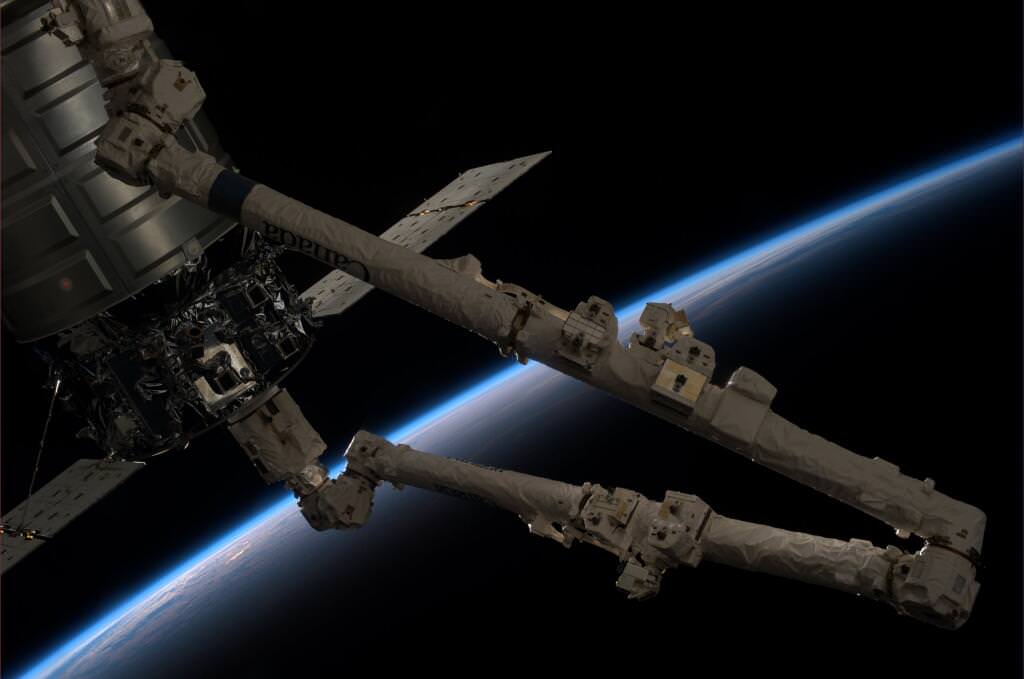
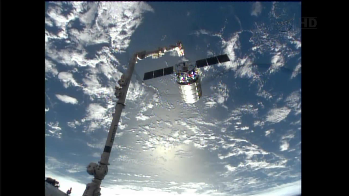
A view of Orbital Sciences' Cygnus spacecraft while it was being released from the International Space Station on Oct. 22. Credit: NASA/Karen Nyberg
Cargo resupply ships are vital for space exploration. These days they bring food, experiments and equipment to astronauts on the International Space Station. And in recent years, it hasn’t just been government agencies sending these things up; SpaceX’s Dragon spacecraft and (just this week) Orbital Sciences’ Cygnus spacecraft brought up cargo of their own to station in recent months.
NASA just published a brief timeline of (real-life) cargo spacecraft, so we thought we’d adapt that information in pictorial form. Here are some of the prominent members of that elite group. Did we miss anything? Let us know in the comments.
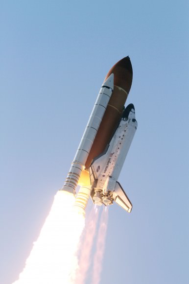
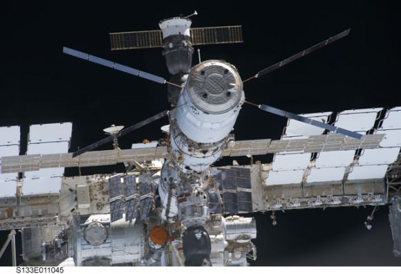
SpaceX’s Dragon in orbit during the CRS-2 mission. It was the first commercial spacecraft to resupply the space station, and since 2012 has completed resupply missions. Credit: NASA/CSA/Chris HadfieldSpace shuttle Discovery heads to space after lifting off from Launch Pad 39A at NASA’s Kennedy Space Center in Florida to begin its final flight to the International Space Station on the STS-133 mission. The shuttle was NASA’s main human spacecraft between 1981 and 2011. Credit: NASAProgress 51 on final approach to the International Space Station. The Russians have been flying versions of this cargo spacecraft since 1978. Credit: NASA TV (screencap)JAXA’s H-II Transfer Vehicle (HTV) during a mission in July 2012. The first demonstration flight took place in 2009. Credit: NASA
The ATV Johannes Kepler docked at the International Space Station. Versions of this spacecraft have flown since 2008. Credit: NASAA line drawing of the TKS (Transportnyi Korabl’ Snabzheniia, or Transport Supply Spacecraft). It was intended to send crew and cargo together in one flight, but delays and a change in program priorities never allowed it to achieve that. According to NASA, versions of TKS (under the Cosmos designation) flew to the Salyut 6 and Salyut 7 space station. The cargo part of the spacecraft was also used for Russian base modules in the Mir space station and International Space Station. Credit: NASA/Wikimedia Commons
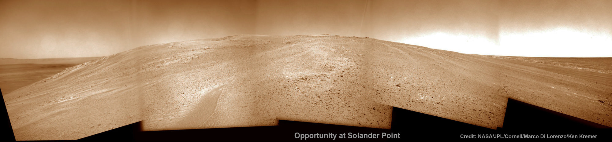
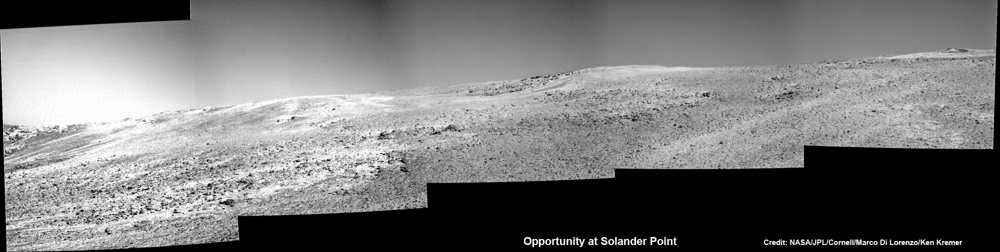
Opportunity starts Martian Mountaineering. NASA’s Opportunity rover captured this southward uphill panoramic mosaic on Oct. 21, 2013 (Sol 3463) after beginning to ascend the northwestern slope of "Solander Point" on the western rim of Endeavour Crater - her 1st mountain climbing adventure. The northward-facing slope will tilt the rover's solar panels toward the sun in the southern-hemisphere winter sky, providing an important energy advantage for continuing mobile operations through the upcoming winter. Assembled from Sol 3463 navcam raw images by Marco Di Lorenzo and Ken Kremer. Credit: NASA/JPL/Cornell/Marco Di Lorenzo/Ken Kremer
Opportunity starts Martian Mountaineering
NASA’s Opportunity rover captured this southward uphill panoramic mosaic on Oct. 21, 2013 (Sol 3463) after beginning to ascend the northwestern slope of “Solander Point” on the western rim of Endeavour Crater – her 1st mountain climbing adventure. The northward-facing slope will tilt the rover’s solar panels toward the sun in the southern-hemisphere winter sky, providing an important energy advantage for continuing mobile operations through the upcoming winter. Assembled from Sol 3463 navcam raw images by Marco Di Lorenzo and Ken Kremer.
Credit: NASA/JPL/Cornell/Marco Di Lorenzo/Ken Kremer Story and imagery updated[/caption]
“This is our first real Martian mountaineering with Opportunity,” said the principal investigator for the rover, Steve Squyres of Cornell University, Ithaca, N.Y.
And it happened right in the middle of the utterly chaotic US government shutdown ! – that seriously harmed some US science endeavors. And at a spot destined to become a science bonanza in the months and years ahead – so long as she stays alive to explore ever more new frontiers.
On Oct. 8, mission controllers on Earth directed the nearly decade old robot to start the ascent of Solander Point – the northern tip of the tallest hill she has encountered after nearly 10 Earth years on Mars.
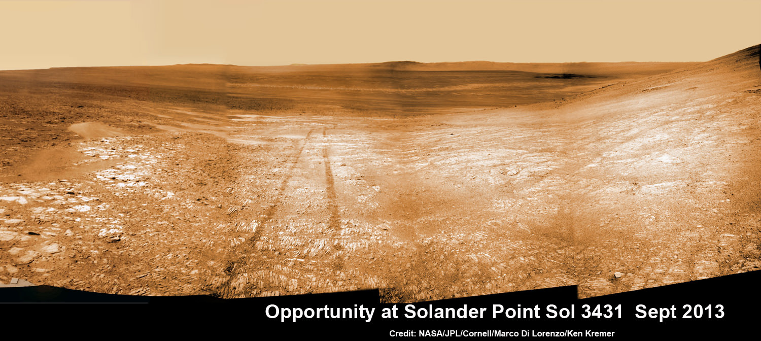
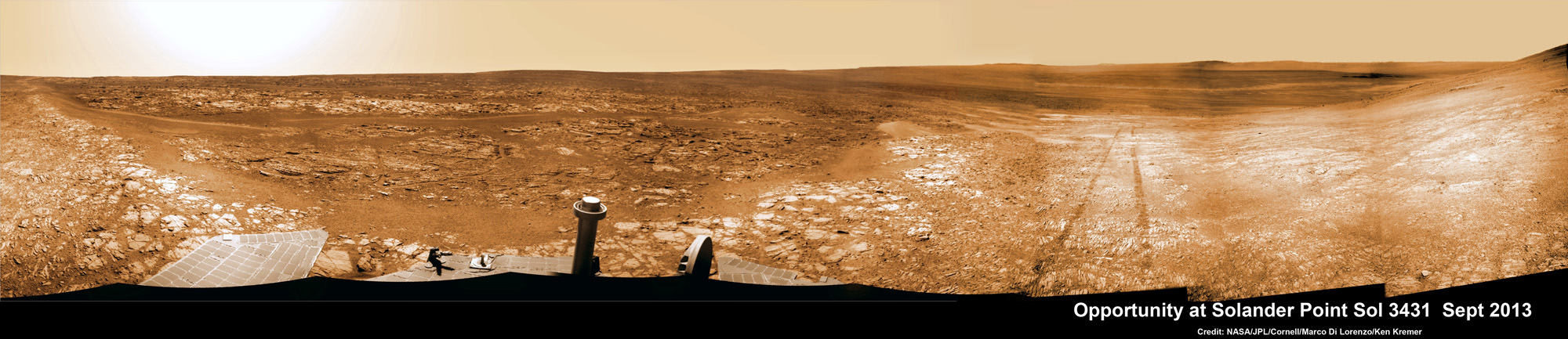
Opportunity starts scaling Solander Point – her1st mountain climbing goal. See the tilted terrain and rover tracks in this mosaic view from Solander Point peering across the vast expanse of huge Endeavour Crater. Opportunity will ascend the mountain looking for clues indicative of a Martian habitable environment. This navcam camera mosaic was assembled from raw images taken on Sol 3431 (Sept.18, 2013). Credit: NASA/JPL/Cornell/Marco Di Lorenzo/Ken Kremer (kenkremer.com). See the complete panoramic view below
The northward-facing slopes at Solander also afford another major advantage. They will tilt the rover’s solar panels toward the sun in the southern-hemisphere winter sky, providing an important energy boost enabling continued mobile operations through the upcoming frigidly harsh winter- her 6th since landing in 2004.
Opportunity will first explore outcrops on the northwestern slopes of Solander Point in search of the chemical ingredients required to sustain life before gradually climbing further uphill to investigate intriguing deposits distributed amongst its stratographic layers.
The rover will initially focus on outcrops located in the lower 20 feet (6 meters) above the surrounding plains on slopes as steep as 15 to 20 degrees.
Opportunity starts scaling Solander Point – her 1st mountain climbing goal. See the tilted terrain and rover tracks in this panoramic view from Solander Point peering across the vast expanse of huge Endeavour Crater. Opportunity will ascend the mountain looking for clues indicative of a Martian habitable environment. This navcam camera mosaic was assembled from raw images taken on Sol 3431 (Sept.18, 2013). Credit: NASA/JPL/Cornell/Marco Di Lorenzo/Ken Kremer (kenkremer.com).
At some later time, Opportunity may ascend Solander farther upward, which peaks about 130 feet (40 meters) above the crater plains.
“We expect we will reach some of the oldest rocks we have seen with this rover — a glimpse back into the ancient past of Mars,” says Squyres.
NASA’s powerful Mars Reconnaissance Orbiter (MRO) circling overhead recently succeeded in identifying clay-bearing rocks during new high resolution survey scans of Solander Point!
As I reported previously, the specially collected high resolution observations by the orbiters Compact Reconnaissance Imaging Spectrometer for Mars (CRISM) were collected in August and being analyzed by the science team. They will be used to direct Opportunity to the most productive targets of interest
“CRISM data were collected,” Ray Arvidson told Universe Today. Arvidson is the mission’s deputy principal scientific investigator from Washington University in St. Louis, Mo.
“They show really interesting spectral features in the [Solander Point] rim materials.”
NASA’s Opportunity rover captured this southward uphill view on Oct. 21, 2013 after beginning to ascend the northwestern slope of “Solander Point” on the western rim of Endeavour Crater. The northward-facing slope will tilt the rover’s solar panels toward the sun in the southern-hemisphere winter sky, providing an important energy advantage for continuing mobile operations through the upcoming winter. Credit: NASA/JPL
The new CRISM survey from Mars orbit yielded mineral maps which vastly improves the spectral resolution – from 18 meters per pixel down to 5 meters per pixel.
This past spring and summer, Opportunity drove several months from the Cape York rim segment to Solander Point.
“At Cape York, we found fantastic things,” Squyres said. “Gypsum veins, clay-rich terrain, the spherules we call newberries. We know there are even larger exposures of clay-rich materials where we’re headed. They might look like what we found at Cape York or they might be completely different.”
The summit of Solander Point
Opportunity rover captured mosaic on Oct. 21, 2013 (Sol 3463) after beginning to ascend the northwestern slope of “Solander Point” on the western rim of Endeavour Crater – her 1st mountain climbing adventure. Assembled from Sol 3463 pancam high resolution raw images by Marco Di Lorenzo and Ken Kremer. Credit: NASA/JPL/Cornell/Marco Di Lorenzo/Ken Kremer
Clay minerals, or phyllosilicates, form in neutral water that is more conducive to life.
At the base of Solander, the six wheeled rover discovered a transition zone between a sulfate-rich geological formation and an older formation. Sulfate-rich rocks form in a wet environment that was very acidic and less favorable to life.
Solander Point is located at the western rim of the vast expanse of Endeavour crater – some 22 kilometers (14 miles) in diameter.
Today marks Opportunity’s 3466th Sol or Martian Day roving Mars – for what was expected to be only a 90 Sol mission.
So far she has snapped over 185,200 amazing images on the first overland expedition across the Red Planet.
Her total odometry stands at over 23.89 miles (38.45 kilometers) since touchdown on Jan. 24, 2004 at Meridiani Planum.
On the opposite side of Mars, Opportunity’s younger sister rover Curiosity is trekking towards gigantic Mount Sharp and recently discovered a patch of pebbles formed by flowing liquid water.
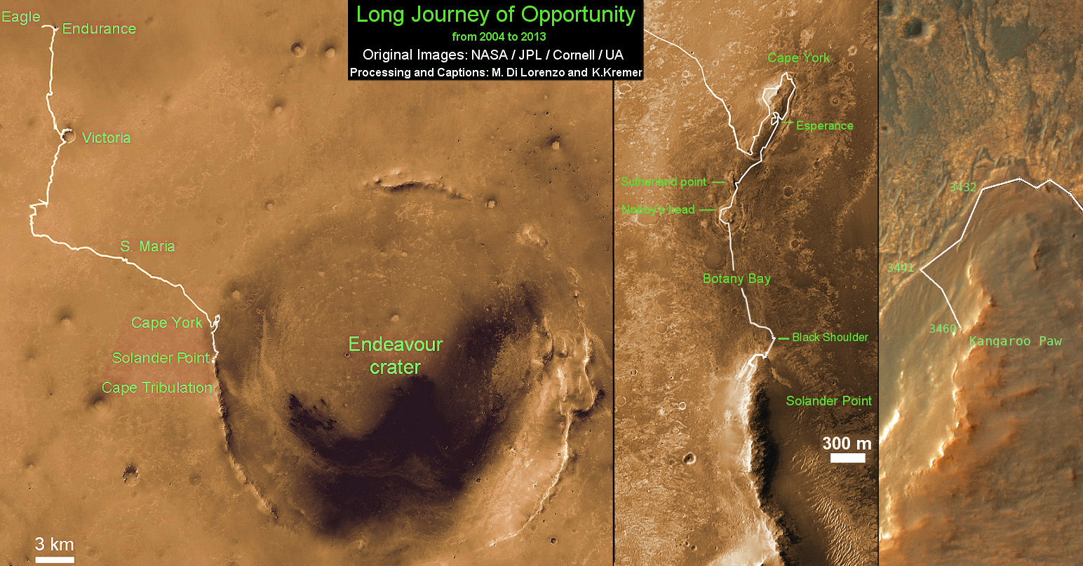
Traverse Map for NASA’s Opportunity rover from 2004 to 2013
This map shows the entire path the rover has driven during nearly 10 years and over 3460 Sols, or Martian days, since landing inside Eagle Crater on Jan 24, 2004 to current location ascending her 1st Martian Mountain – Solander Point – at the western rim of Endeavour Crater. Opportunity discovered clay minerals at Esperance – indicative of a habitable zone and seeks clay minerals now at Solander. Credit: NASA/JPL/Cornell/ASU/Marco Di Lorenzo/Ken Kremer
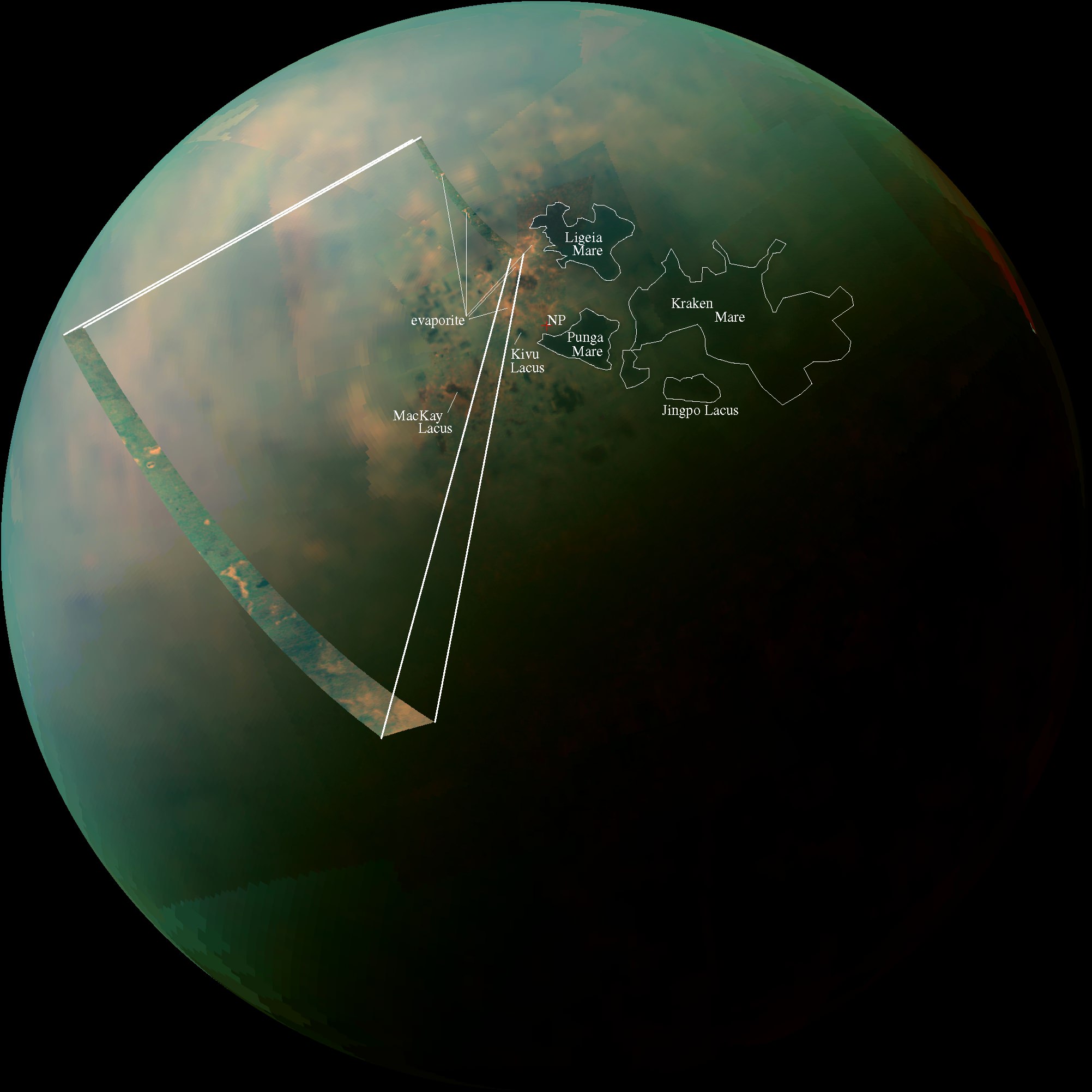
Titan's north pole is home to many methane lakes. Credit: NASA
A combination of exceptionally clear weather, the steady approach of northern summer, and a poleward orbital path has given Cassini — and Cassini scientists — unprecedented views of countless lakes scattered across Titan’s north polar region. In the near-infrared mosaic above they can be seen as dark splotches and speckles scattered around the moon’s north pole. Previously observed mainly via radar, these are the best visual and infrared wavelength images ever obtained of Titan’s northern “land o’ lakes!”
Titan is currently the only other world besides Earth known to have stable bodies of liquid on its surface, but unlike Earth, Titan’s lakes aren’t filled with water — instead they’re full of liquid methane and ethane, organic compounds which are gases on Earth but liquids in Titan’s incredibly chilly -290º F (-180º C) environment.
While one large lake and a few smaller ones have been previously identified at Titan’s south pole, curiously almost all of Titan’s lakes appear near the moon’s north pole.
Infrared observations of Titan’s northern lakes. The cross marks Titan’s geographic north pole. (NASA/JPL-Caltech/SSI)
For an idea of scale, the large lake at the upper right above (and the largest lake on Titan) Kraken Mare is comparative in size to the Caspian Sea and Lake Superior combined. Kraken Mare is so large that sunlight was seen reflecting off its surface in 2009. Punga Mare, nearest Titan’s pole, is 240 miles (386 km) across.
Besides revealing the (uncannily) smooth surfaces of lakes — which appear dark in near-infrared wavelengths but would also be darker than the surrounding landscape in visible light — these Cassini images also show an unusually bright terrain surrounding them. Since the majority of Titan’s lakes are found within this bright region it’s thought that there could be a geologic correlation; is this Titan’s version of karst terrain, like what’s found in the southeastern U.S. and New Mexico? Could these lakes be merely the visible surfaces of a vast underground hydrocarbon aquifer? Or are they shallow pools filling depressions in an ancient lava flow?
Annotated infrared mosaic of Titan’s north pole (NASA/JPL-Caltech/SSI)
Or, are they the remains of once-larger lakes and seas which have since evaporated? The orange-hued regions in the false-color mosaic may be evaporite — the Titan equivalent of salt flats on Earth. The evaporated material is thought to be organic chemicals originally from Titan’s haze particles that were once dissolved in liquid methane.
“Is this an indication that with increased warmth, the seas and lakes are starting to evaporate, leaving behind a deposit of organic material,” wrote Carolyn Porco, Cassini Imaging Team Leader, in an email earlier today. “…in other words, the Titan equivalent of a salt-flat?”
The largest lake at Titan’s south pole, Ontario Lacus, has been previously compared to such an ephemeral lake in Namibia called the Etosha Pan. (Read more here.)
These observations are only possible because of the extended and long-term study of Saturn and its family of moons by the Cassini spacecraft, which began with its establishing orbit in 2004 and has since continued across multiple seasons over a third of the ringed planet’s year. The existence of methane lakes on Titan is undoubtedly fascinating, but how deep the lakes are, where they came from and how they behave in Titan’s environment have yet to be discovered. Luckily, the changing season is on our side.
“Titan’s northern lakes region is one of the most Earth-like and intriguing in the solar system,” said Linda Spilker, Cassini project scientist, based at NASA’s Jet Propulsion Laboratory, Pasadena, Calif. “We know lakes here change with the seasons, and Cassini’s long mission at Saturn gives us the opportunity to watch the seasons change at Titan, too. Now that the sun is shining in the north and we have these wonderful views, we can begin to compare the different data sets and tease out what Titan’s lakes are doing near the north pole.”
The images shown above were obtained by Cassini’s visual and infrared mapping spectrometer (VIMS) during a close flyby of Titan on Sept. 12, 2013.
Read more on the Cassini Imaging Central Laboratory for Operations (CICLOPS) site here and on the NASA site here.
“But how thrilling it is to still be uncovering new territory on this fascinating moon… a place that, until Cassini’s arrival at Saturn nearly 10 years ago, was the largest single expanse of unseen terrain we had remaining in our solar system. Our adventures here have been the very essence of exploration. And it’s not over yet!”
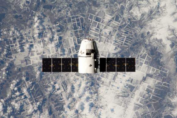
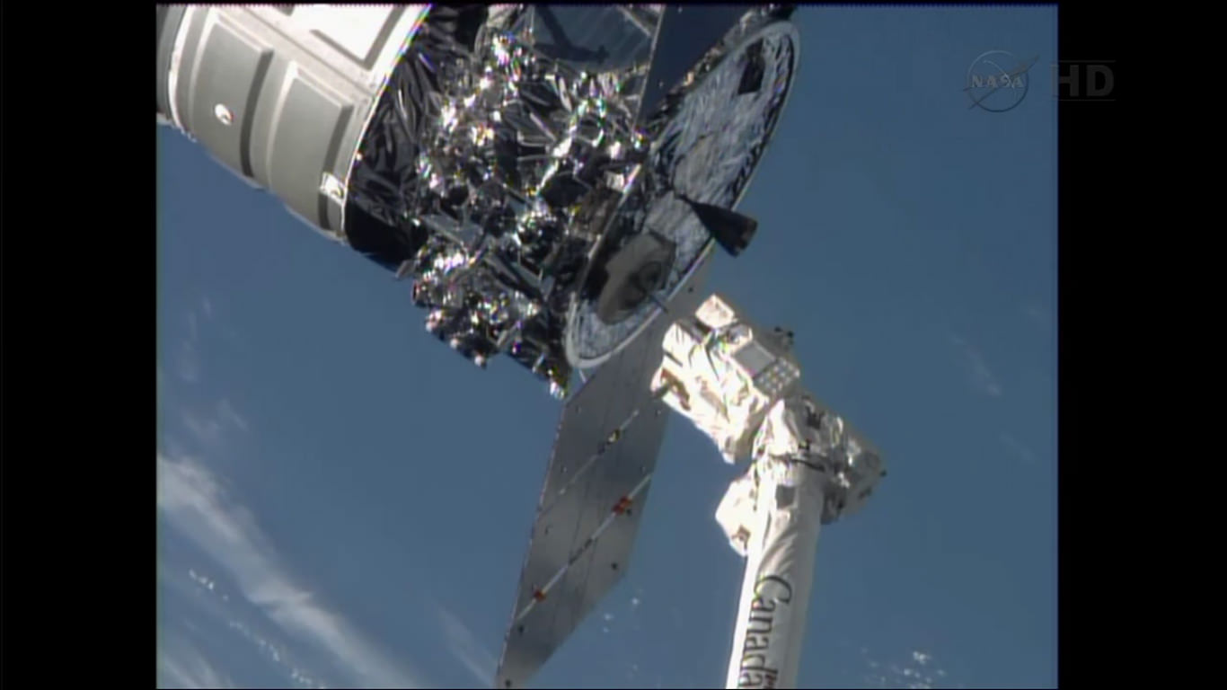
The Cygnus commercial resupply craft departed the ISS this morning (Oct. 22) to complete its maiden voyage after being released from Canadarm2 by station astronauts. Credit: NASA TV
Commercial space took another major leap forward this morning, Oct 22., when the privately developed Cygnus cargo vehicle undocked from the International Space Station on its historic maiden flight and successfully completed a highly productive month long stay during its demonstration mission – mostly amidst the US government shutdown.
The Cygnus was maneuvered about 10 meters (30 feet) away from the station and held in the steady grip of the stations fully extended robotic arm when astronauts Karen Nyberg and Luca Parmitano unlatched the arm and released the ship into free space at 7:31 a.m. EDT today – signifying an end to joint flight operations.
The next Cygnus resupply vessel is due to blast off in mid-December and is already loaded with new science experiments for microgravity research and assorted gear and provisions.
After the Expedition 37 crew members quickly pulled the arm back to a distance 1.5 meters away from Cygnus, ground controllers issued a planned “abort” command to fire the ships thrusters and safely depart from the massive orbiting lab complex.
Space Station robotic arm releases Cygnus after detachment from the ISS Harmony node. Credit: NASA TV
“It’s been a great mission. Nice work today!” radioed Houston Mission Control at NASA’s Johnson Space Center.
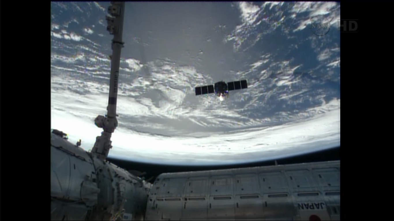
The vehicles were flying over the Atlantic Ocean and off the east coast of Argentina as Cygnus left the station some 250 miles (400 km) overhead in low Earth orbit.
The event was carried live on NASA TV and Cygnus was seen moving rapidly away.
Barely five minutes later Cygnus was already 200 meters away, appeared very small in the cameras view and exited the imaginary “Keep Out Sphere” – a strictly designated safety zone around the million pound station.
Cygnus commercial cargo craft rapidly departed the ISS this morning (Oct. 22) after release from the Canadarm2 robotic arm. Station modules visible at bottom. Credit: NASA TV
The Cygnus resupply ship delivered about 1,300 pounds (589 kilograms) of cargo, including food, clothing, water, science experiments, spare parts and gear to the six person Expedition 37 crew.
After the crew unloaded all that cargo, they packed the ship with 2,850 pounds of no longer needed trash.
On Wednesday (Oct. 23), a pair of deorbit burns with target Cygnus for a destructive reentry back into the Earth’s atmosphere at 2:18 p.m. EDT, to plummet harmlessly into the Pacific Ocean.
Cygnus was developed by Orbital Sciences Corp. with seed money from NASA in a public-private partnership between NASA and Orbital Sciences under NASA’s COTS commercial transportation initiative.
SpaceX Corp. was also awarded a COTS contract to develop the Dragon cargo carrier so that NASA would have a dual capability to stock up the station.
COTS was aimed at fostering the development of America’s commercial space industry to deliver critical and essential supplies to the ISS following the retirement of the Space Shuttle program.
“Congratulations to the teams at Orbital Sciences and NASA who worked hard to make this demonstration mission to the International Space Station an overwhelming success,” NASA Administrator Charles Bolden said in a statement.
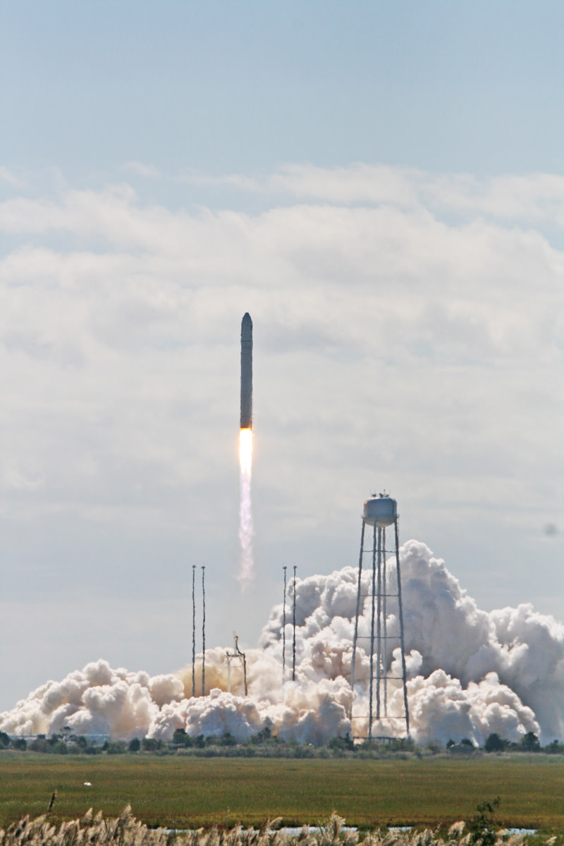
Antares rocket lifts off at 10:58 a.m. EDT Sept 18 with commercial Cygnus cargo resupply ship bound for the International Space Station (ISS) from Mid-Atlantic Regional Spaceport Pad-0A at NASA’s Wallops Flight Facility in Virginia. Credit: Ken Kremer (kenkremer.com)
“We are delighted to now have two American companies able to resupply the station. U.S. innovation and inspiration have once again shown their great strength in the design and operation of a new generation of vehicles to carry cargo to our laboratory in space. Orbital’s success today is helping make NASA’s future exploration to farther destinations possible.”
America completely lost its capability to send humans and cargo to the ISS when NASA’s space shuttles were forcibly retired in 2011. Orbital Sciences and SpaceX were awarded NASA contracts worth over $3 Billion to restore the unmanned cargo resupply capability over 20 flights totally.
“Antares next flight is scheduled for mid December,” according to Frank Culbertson, former astronaut and now Orbital’s executive Vice President responsible for the Antares and Cygnus programs.
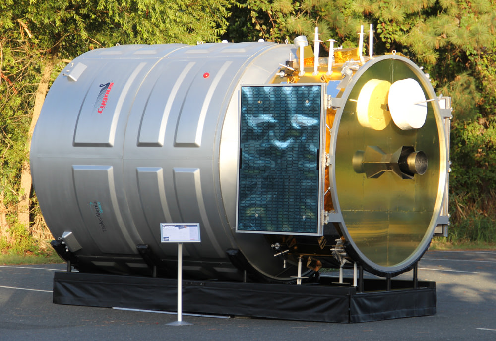
After launching to orbit atop the Antares rocket on Sept. 18, the first ever Cygnus cargo spacecraft chased the ISS and docked on Sept 29. Here is full scale, high fidelity mockup of Cygnus to give a feel for its size being similar to a small room. Credit: Ken Kremer (kenkremer.com)
On Expedition 27 in May 2011, NASA astronaut Cady Coleman participated in the Auroral Oval Spiral Top experiment. Credit: NASA
Wow! That was our reaction to seeing this picture (and others) of a light show aboard the International Space Station. After confirming with NASA that the images circulating lately on social media are real, we were directed to the Japan Aerospace Exploration Agency (JAXA), who co-ordinated this experiment.
The work is called “Auroral Oval Spiral Top” and was done in the Kibo module on May 12, 2011, JAXA said. This was the second version of the experiment, which initially ran April 30, 2009 during Expedition 19.
Spiral Top performed in 2009. The art project was an earlier version of the Auroral Oval Spiral Top experiment that was done in May 2011. Credit: NASA/JAXA
“Auroral Oval Spiral Top uses a spinning top that has arms illuminating with LED linear light sources and point light sources. Various movements of the spinning top floating in microgravity show aurora-like light traces,” JAXA stated on a web page about the experiment.
The project, JAXA added, is “designed to produce aurora-like luminescence traces using a spinning top with both linear and point light sources. In microgravity, the center of gravity of the spinning top continuously and randomly moves while it is spinning. Using the characteristics of the top in microgravity, the project tries to produce various light arts using its unexpected movements/spins, by changing attaching locations of its arms and weights.”
Takuro Osaka, a professor at the University of Tsukuba, was the principal investigator of this art project. What are your favorite experiments performed by astronauts in space? Let us know in the comments.
Another view of the Auroral Oval Spiral Top experiment. Credit: NASA
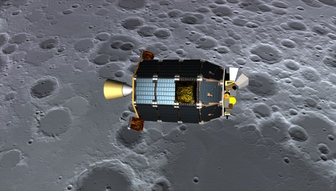
An artist's concept of NASA's Lunar Atmosphere and Dust Environment Explorer (LADEE) spacecraft seen orbiting near the surface of the moon after successfully entering lunar orbit on Oct. 6, 2013. Credit: NASA Ames / Dana Berry
NASA’s new LADEE spacecraft successfully entered lunar orbit, is operating beautifully and has begun shooting its radical laser communications experiment despite having to accomplish a series of absolutely critical do-or-die orbital insertion engine firings with a “skeleton crew ” – all this amidst the NASA and US government shutdown, NASA Ames Research Center Director Pete Worden told Universe Today in a LADEE mission exclusive.
During the two and a half week long NASA shutdown, engineers had to fire LADEE’s maneuvering thrusters three times over six days – first to brake into elliptical orbit about the Moon and then lower it significantly and safely into a circular commissioning orbit.
“All burns went super well,” Ames Center Director Worden told me exclusivly. And he is extremely proud of the entire team of “dedicated” professional men and women who made it possible during the shutdown.
“It says a lot about our people’s dedication and capability when a skeleton crew can get a new spacecraft into lunar orbit and fully commissioned in the face of a shutdown!” Worden said to Universe Today.
“I’m really happy that everyone’s back.”
After achieving orbit, a pair of additional engine burns reduced LADEE’s altitude and period into its initial commissioning orbit and teams began the month long activation and instrument checkout phase.
“We are at the commissioning orbit of 250 km,” said Worden.
And to top all that off, LADEE’s quartet of science instruments are checked out and the ground – breaking laser communications experiment that will bring about a quantum leap in transmitting space science data has already begun its work!
“All instruments are fully checked out with covers deployed.”
“We’ve begun the Lunar Laser Communications Demonstration (LLCD) tests and its working very well,” Worden explained.
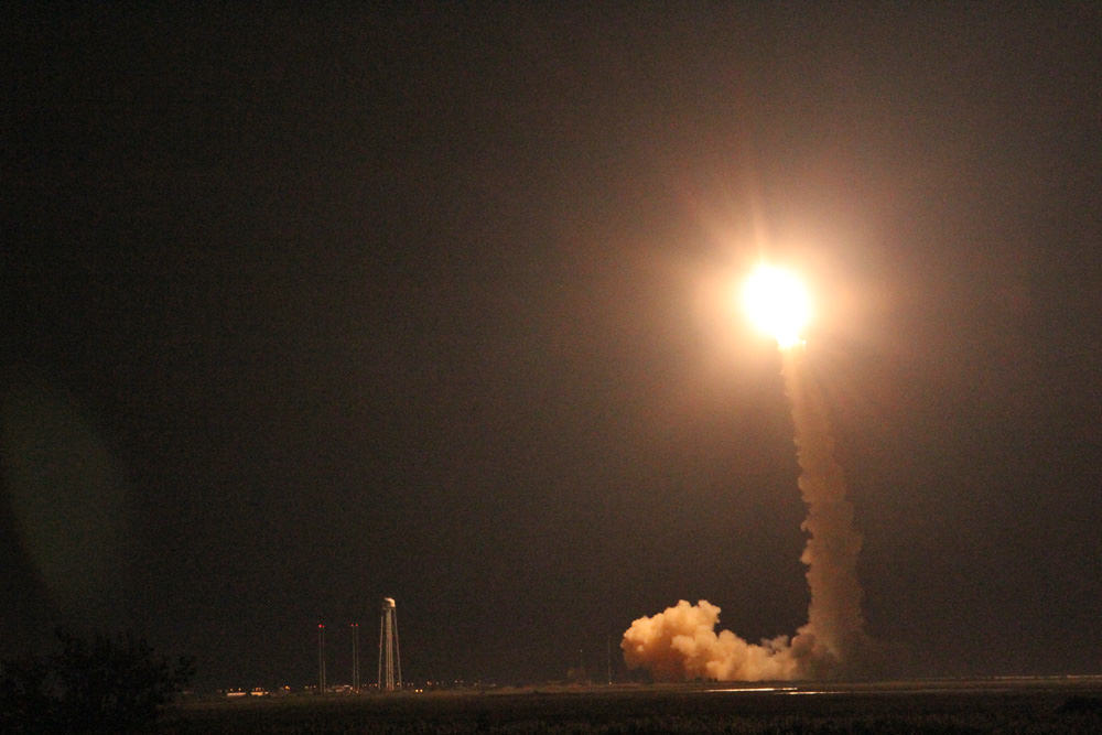
NASA’s LADEE lunar orbiter fired its main engine on Oct. 6 to enter lunar orbit in the midst of the US government shutdown. Credit: NASA
And that’s the whole point of the LADEE mission in the first place.
However, orbital mechanics follows the natural laws of the Universe, continues unabated and waits for no one in Washington, D.C.
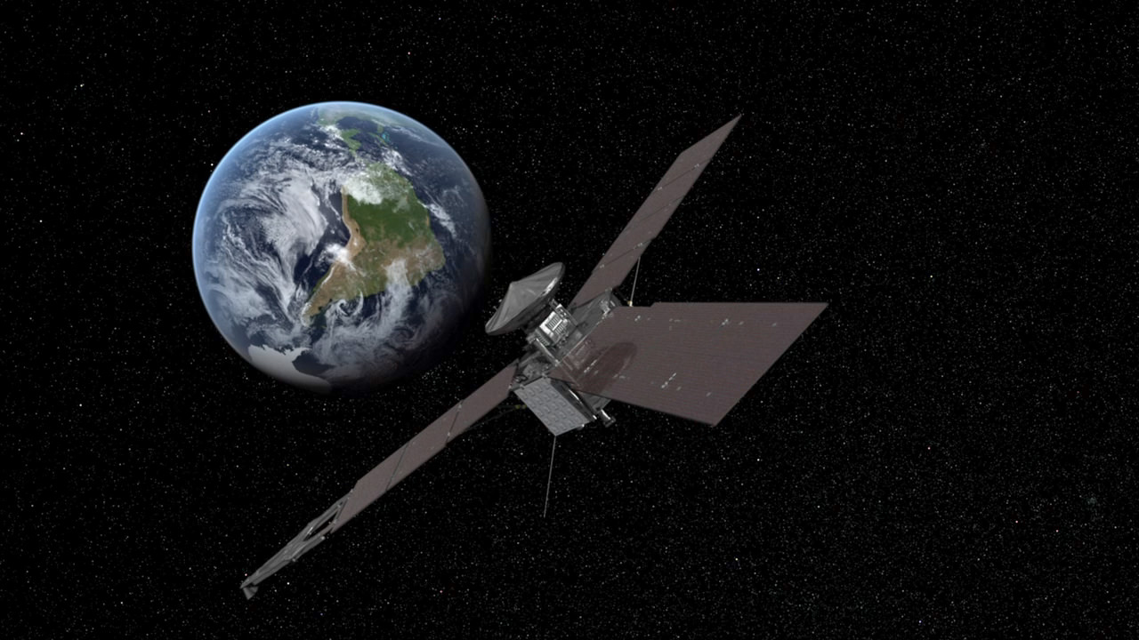
NASA’s Jupiter-bound Juno orbiter also flew by Earth amidst the DC shutdown showdown on Oct. 9 for a similarly critical do-or-die gravity assisted speed boost and trajectory targeting maneuver.
The stakes were extremely high for NASA’s Lunar Atmosphere and Dust Environment Explorer (LADEE) mission because the spacecraft was on course for the Moon and absolutely had to ignite its main engine on the Sunday morning of Oct. 6.
There were no second chances. If anything failed, LADEE would simply sail past the Moon with no hope of returning later.
So, mission controllers at NASA Ames commanded LADEE to ignite its main engine and enter lunar orbit on Oct. 6 following the spectacular Sept. 6 night launch from NASA’s Wallops Island spaceport in Virginia.
Launch of NASA’s LADEE lunar orbiter on Friday night Sept. 6, at 11:27 p.m. EDT on the maiden flight of the Minotaur V rocket from NASA Wallops, Virginia, viewing site 2 miles away. Antares rocket launch pad at left. Credit: Ken Kremer/kenkremer.com
The approximately four minute long burn know as Lunar Orbit Insertion burn 1 (LOI-1) began with LADEE’s arrival at the Moon following three and a half long looping orbits of the Earth.
LOI-1 changed the spacecrafts velocity by 329.8 meters/sec so that the couch sized probe could be captured by the Moon’s gravity and be placed into a 24 hour polar elliptical orbit.
The LOI-2 maneuver on Oct. 9 put LADEE into a 4-hour elliptic lunar orbit. The third and final LOI-3 burn occurred on Oct. 12, and put the spacecraft into the 2-hour commissioning orbit (roughly 235 Km x 250 Km), according to a NASA statement.
The 844 pound (383 kg) robot explorer was assembled at NASA’s Ames Research Center, Moffett Field, Calif., and is a cooperative project with NASA Goddard Spaceflight Center in Maryland.
“LADEE is the first NASA mission with a dedicated laser communications experiment,” said Don Cornwell, mission manager for the Lunar Laser Communications Demonstration (LLCD), NASA’s Goddard Space Flight Center, Greenbelt, Md, during an interview with Universe Today at the LADEE launch.
“With the LLCD experiment, we’ll use laser communications to demonstrate at least six times more data rate from the moon than what we can do with a radio system with half the weight and 25 percent less power,” said Cornwell.
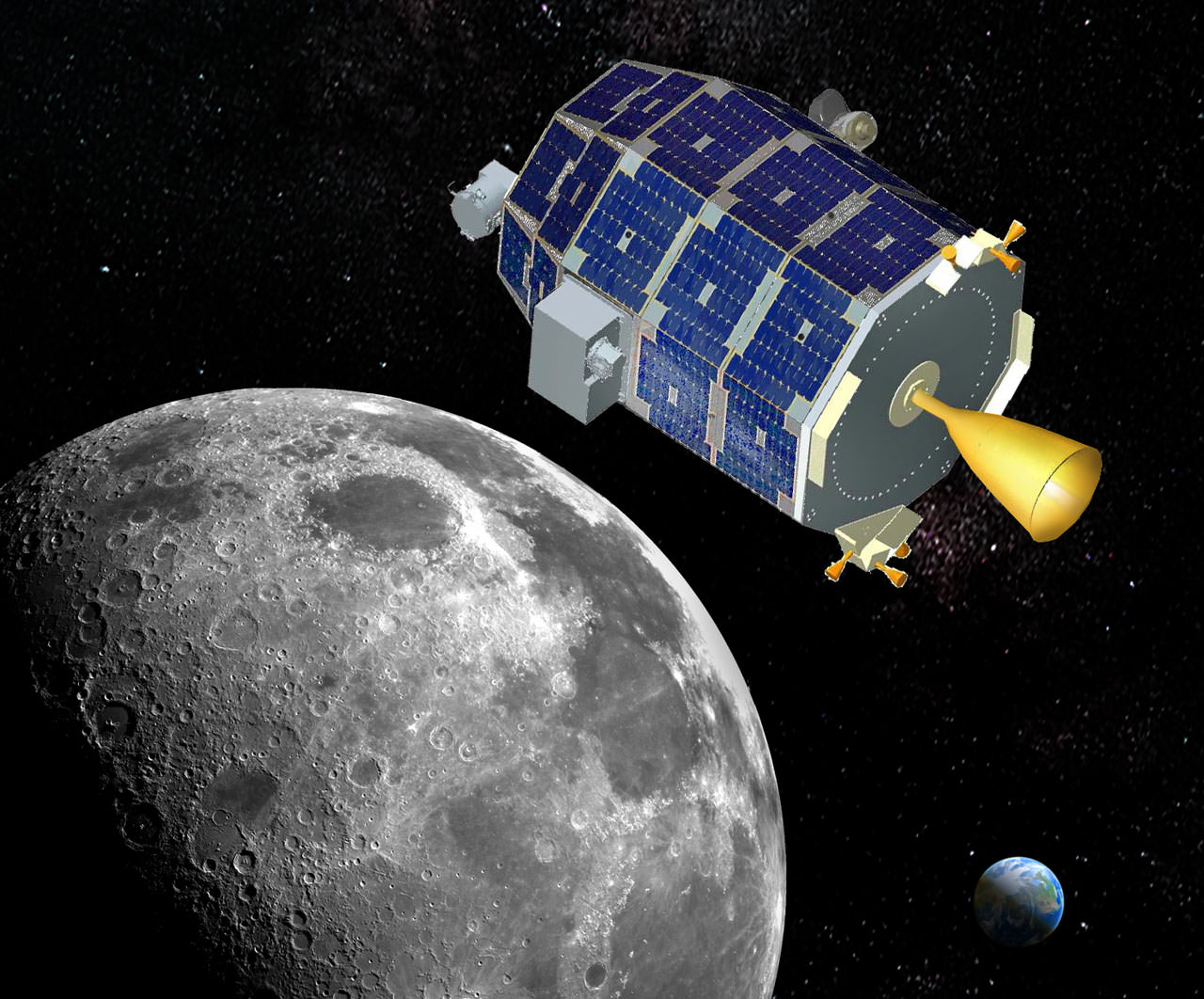
The LADEE satellite in lunar orbit. The revolutionary modular science probe is equipped with a Lunar Laser Communication Demonstration (LLCD) that will attempt to show two-way laser communication beyond Earth is possible, expanding the possibility of transmitting huge amounts of data. This new ability could one day allow for 3-D High Definition video transmissions in deep space to become routine. Credit: NASA
The LLCD will be operated for about 30 days during the time of the commissioning orbit period.
The purpose of LADEE is to collect data that will inform scientists in unprecedented detail about the ultra thin lunar atmosphere, environmental influences on lunar dust and conditions near the surface. In turn this will lead to a better understanding of other planetary bodies in our solar system and beyond.
The $280 million probe is built on a revolutionary ‘modular common spacecraft bus’, or body, that could dramatically cut the cost of exploring space and also be utilized on space probes to explore a wide variety of inviting targets in the solar system.
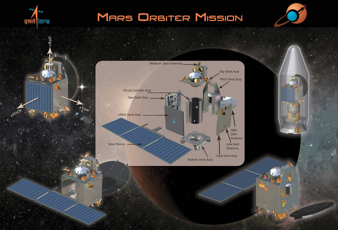
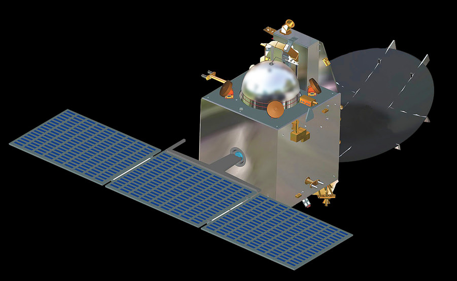
Graphic outlines India’s first ever probe to explore the Red Planet known as the Mars Orbiter Mission (MOM). It could liftoff as early as Oct. 28 from the Satish Dhawan Space Centre SHAR, Srihairkota, India. Credit: ISRO
India is gearing up for its first ever space undertaking to the Red Planet – dubbed the Mars Orbiter Mission, or MOM – which is the brainchild of the Indian Space Research Organization, or ISRO.
Among other objectives, MOM will conduct a highly valuable search for potential signatures of Martian methane – which could stem from either living or non living sources. The historic Mars bound probe also serves as a forerunner to bolder robotic exploration goals.
If all goes well India would become only the 4th nation or entity from Earth to survey Mars up close with spacecraft, following the Soviet Union, the United States and the European Space Agency (ESA).
The 1,350 kilogram (2,980 pound) orbiter, also known as ‘Mangalyaan’, is slated to blast off as early as Oct. 28 atop India’s highly reliable Polar Satellite Launch Vehicle (PSLV) from a seaside launch pad in Srihanikota, India.
India’s first ever probe to explore the Red Planet known as the Mars Orbiter Mission (MOM), is due to liftoff as early as Oct. 28 from the Satish Dhawan Space Centre SHAR, Srihairkota, India. Credit: ISRO
MOM is outfitted with an array of five science instruments including a multi color imager and a methane gas sniffer to study the Red Planet’s atmosphere, morphology, mineralogy and surface features. Methane on Earth originates from both biological and geological sources.
ISRO officials are also paying close attention to the local weather to ascertain if remnants from Tropical Cyclone Phaillin or another developing weather system in the South Pacific could impact liftoff plans.
The launch target date will be set following a readiness review on Friday, said ISRO Chairman K. Radhakrishnan according to Indian press reports.
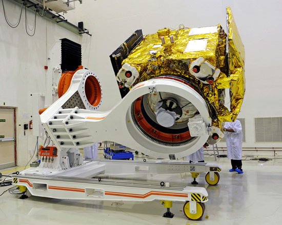
India’s Mars Orbiter Mission (MOM) spacecraft being prepared for a prelaunch test at Satish Dhawan Space Centre SHAR, Srihairkota. Credit: ISRO
‘Mangalyaan’ is undergoing final prelaunch test and integration at ISRO’s Satish Dhawan Space Centre SHAR, Srihairkota on the east coast of Andhra Pradesh state following shipment from ISRO’s Bangalore assembly facility on Oct. 3.
ISRO has already assembled the more powerful XL extended version of the four stage PSLV launcher at Srihairkota.
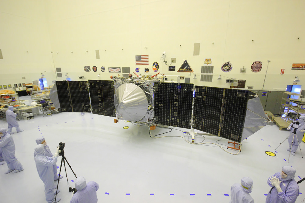
The upcoming Nov. 18 blastoff of NASA’s new MAVEN Mars orbiter was threatened by the US Federal Government shutdown when all launch processing work ceased on Oct. 1. Spacecraft preps had now resumed on Oct. 3 after receiving an emergency exemption. MAVEN was unveiled to the media, including Universe Today, inside the cleanroom at the Kennedy Space Center on Sept. 27, 2013. With solar panels unfurled, this is exactly how MAVEN looks when flying through space. Credit: Ken Kremer/kenkremer.com
MAVEN’s on time blastoff from Florida on Nov. 18, had been threatened by the chaos caused by the partial US government shutdown that finally ended this morning (Oct. 17), until the mission was granted an ‘emergency exemption’ due to the critical role it will play in relaying data from NASA’s ongoing pair of surface rovers – Curiosity and Opportunity.
NASA is providing key communications and navigation support to ISRO and MOM through the agency’s trio of huge tracking antennas in the Deep Space Network (DSN).
As India’s initial mission to Mars, ISRO says that the mission’s objectives are both technological and scientific to demonstrate the nation’s capability to design an interplanetary mission and carry out fundamental Red Planet research with a suite of indigenously built instruments.
MOM’s science complement comprises includes the tri color Mars Color Camera to image the planet and its two moon, Phobos and Diemos; the Lyman Alpha Photometer to measure the abundance of hydrogen and deuterium and understand the planets water loss process; a Thermal Imaging Spectrometer to map surface composition and mineralogy, the MENCA mass spectrometer to analyze atmospheric composition, and the Methane Sensor for Mars to measure traces of potential atmospheric methane down to the ppm level.
It will be of extremely great interest to compare any methane detection measurements from MOM to those ongoing from NASA’s Curiosity rover – which found ground level methane to be essentially nonexistent – and Europe’s planned 2016 ExoMars Trace Gas Orbiter.
MOM’s design builds on spacecraft heritage from India’s Chandrayaan 1 lunar mission that investigated the Moon from 2008 to 2009.
The 44 meter (144 ft) PSLV will launch MOM into an initially elliptical Earth parking orbit of 248 km x 23,000 km. A series of six orbit raising burns will eventually dispatch MOM on a trajectory to Mars by late November, assuming an Oct. 28 liftoff.
Following a 300 day interplanetary cruise phase, the do or die orbital insertion engine will fire on September 14, 2014 and place MOM into an 377 km x 80,000 km elliptical orbit.
NASA’s MAVEN is also due to arrive in Mars orbit during September 2014.
The $69 Million ‘Mangalyaan’ mission is expected to continue gathering measurements at the Red Planet for at least six months and perhaps ten months or longer.
Juno swoops over Argentina This reconstructed day side image of Earth is one of the 1st snapshots transmitted back home by NASA’s Jupiter-bound Juno spacecraft during its speed boosting flyby on Oct. 9, 2013. It was taken by the probes Junocam imager and methane filter at 12:06:30 PDT and an exposure time of 3.2 milliseconds. Juno was flying over South America and the southern Atlantic Ocean. The coastline of Argentina is visible at top right. Credit: NASA/JPL/SwRI/MSSS/Ken Kremer
Juno swoops over Argentina
This reconstructed day side image of Earth is one of the 1st snapshots transmitted back home by NASA’s Jupiter-bound Juno spacecraft during its speed boosting flyby on Oct. 9, 2013. It was taken by the probes Junocam imager and methane filter at 12:06:30 PDT and an exposure time of 3.2 milliseconds. Juno was flying over South America and the southern Atlantic Ocean. The coastline of Argentina is visible at top right. Credit: NASA/JPL/SwRI/MSSS/Ken Kremer
See another cool Junocam image below[/caption]
Engineers have deftly managed to successfully restore NASA’s Jupiter-bound Juno probe back to full operation following an unexpected glitch that placed the ship into ‘safe mode’ during the speed boosting swing-by of Earth on Wednesday, Oct. 9 – the mission’s top scientist told Universe Today late Friday.
“Juno came out of safe mode today!” Juno principal investigator Scott Bolton happily told me Friday evening. Bolton is from the Southwest Research Institute (SwRI), San Antonio, Texas.
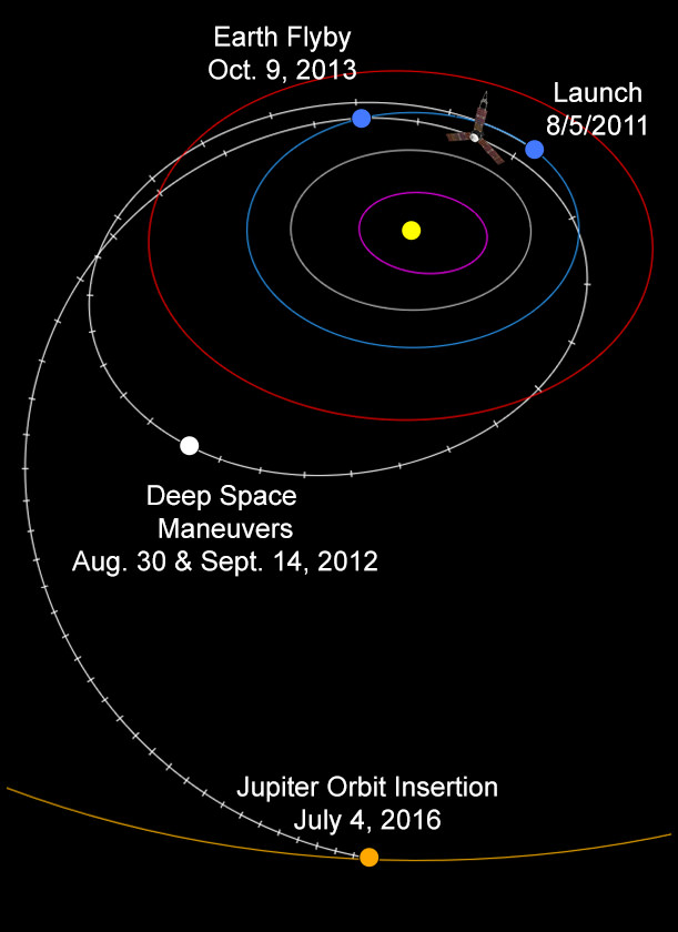
The solar powered Juno spacecraft conducted a crucial slingshot maneuver by Earth on Wednesday that accelerated its velocity by 16,330 mph (26,280 km/h) thereby enabling it to be captured into polar orbit about Jupiter on July 4, 2016.
Dayside view of a sliver of Earth snapped by Juno during flyby on Oct. 9, 2013. This mosaic has been reconstructed from raw image data captured by methane infrared filter on Junocam imager at 11:57:30 PDT. Credit: NASA/JPL/SwRI/MSSS/Ken Kremer/Marco Di Lorenzo
“The safe mode did not impact the spacecraft’s trajectory one smidgeon!”
Juno exited safe mode at 5:12 p.m. ET Friday, according to a statement from the Southwest Research Institute. Safe mode is a designated fault protective state that is preprogrammed into spacecraft software in case something goes amiss.
“The spacecraft is currently operating nominally and all systems are fully functional,” said the SwRI statement.
Although the Earth flyby did accomplish its primary goal of precisely targeting Juno towards Jupiter – within 2 kilometers of the aim point ! – the ship also suffered an unexplained anomaly that placed Juno into ‘safe mode’ at some point during the swoop past Earth.
“After Juno passed the period of Earth flyby closest approach at 12:21 PM PST [3:21 PM EDT] and we established communications 25 minutes later, we were in safe mode,” Juno Project manager Rick Nybakken, told me in a phone interview soon after Wednesday’s flyby of Earth. Nybakken is from NASA’s Jet Propulsion Lab in Pasadena, CA.
Credit: NASA/JPL
Nybakken also said that the probe was “power positive and we have full command ability.”
So the mission operations teams at JPL and prime contractor Lockheed Martin were optimistic about resolving the safe mode issue right from the outset.
“The spacecraft acted as expected during the transition into and while in safe mode,” acording to SwRI.
During the flyby, the science team also planned to observe Earth using most of Juno’s nine science instruments since the slingshot also serves as an important dress rehearsal and key test of the spacecraft’s instruments, systems and flight operations teams.
“The Juno science team is continuing to analyze data acquired by the spacecraft’s science instruments during the flyby. Most data and images were downlinked prior to the safe mode event.”
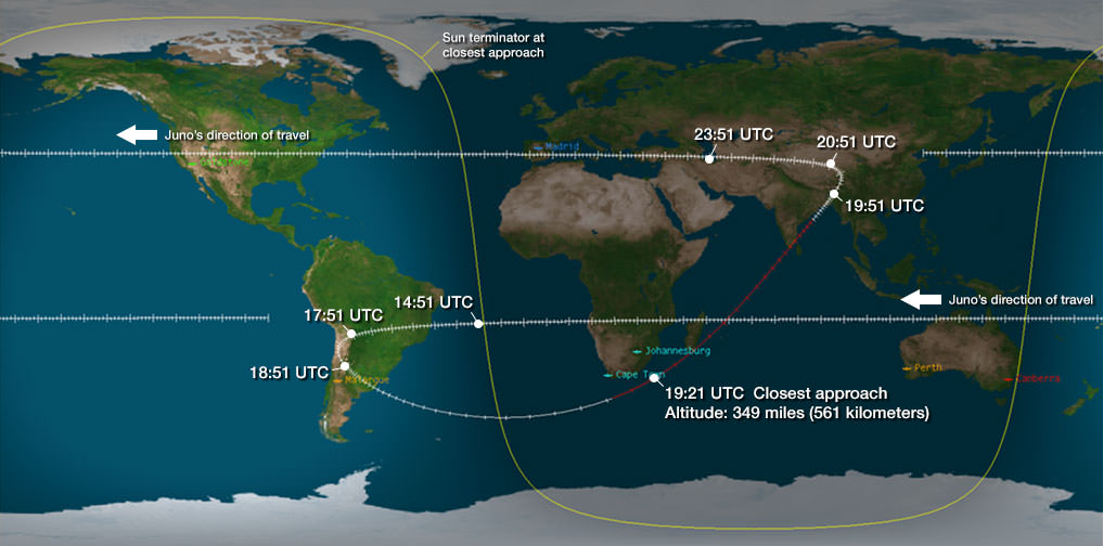
Juno’s closest approach took place over the ocean just off the tip of South Africa at about 561 kilometers (349 miles).
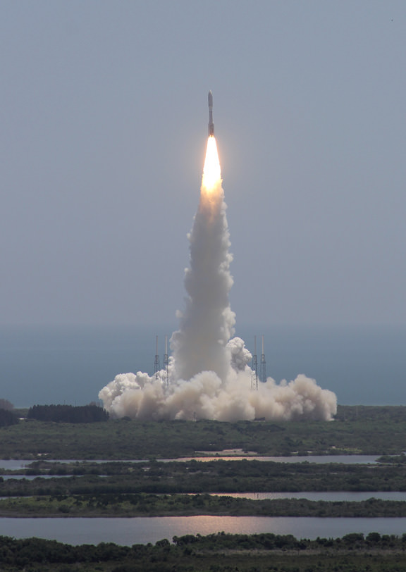
Juno launched atop an Atlas V rocket two years ago from Cape Canaveral Air Force Station, FL, on Aug. 5, 2011 on a journey to discover the genesis of Jupiter hidden deep inside the planet’s interior.
The $1.1 Billion Juno probe is continuing on its 2.8 Billion kilometer (1.7 Billion mile) outbound trek to the Jovian system.
During a one year long science mission – entailing 33 orbits lasting 11 days each – the probe will plunge to within about 3000 miles of the turbulent cloud tops and collect unprecedented new data that will unveil the hidden inner secrets of Jupiter’s origin and evolution.
“Jupiter is the Rosetta Stone of our solar system,” says Bolton. “It is by far the oldest planet, contains more material than all the other planets, asteroids and comets combined and carries deep inside it the story of not only the solar system but of us. Juno is going there as our emissary — to interpret what Jupiter has to say.”
Read more about Juno’s flyby in my articles – at NBC News; here, and Universe Today; here, here and here
Juno swoops over Argentina This reconstructed day side image of Earth is one of the 1st snapshots transmitted back home by NASA’s Jupiter-bound Juno spacecraft during its speed boosting flyby on Oct. 9, 2013. It was taken by the probes Junocam imager and methane filter at 12:06:30 PDT and an exposure time of 3.2 milliseconds. Juno was flying over South America and the southern Atlantic Ocean. The coastline of Argentina is visible at top right. Credit: NASA/JPL/SwRI/MSSS/Ken Kremer
Following the speed boosting slingshot of Earth on Wednesday, Oct. 9, that sent NASA’s Juno orbiter hurtling towards Jupiter, the probe has successfully transmitted back data and the very first flyby images despite unexpectedly going into ‘safe mode’ during the critical maneuver.
“Juno is transmitting telemetry today,” spokesman Guy Webster, of NASA’s Jet Propulsion Lab (JPL), told me in a phone interview late today (Oct. 10), as Juno continues sailing on its 2.8 Billion kilometer (1.7 Billion mile) outbound trek to the Jovian system.
The new images of Earth captured by the Junocam imager serves as tangible proof that Juno is communicating.
“Juno is still in safe mode today (Oct. 10),” Webster told Universe Today.
“Teams at mission control at JPL and Lockheed Martin are actively working to bring Juno out of safe mode. And that could still require a few days,” Webster explained.
Lockheed Martin is the prime contractor for Juno.
The initial raw images of Earth snapped by the craft’s Junocam imager were received by ground stations late today.
See above a day light image mosaic which I reconstructed and realigned based on the original raw image (see below) taken with the camera’s methane filter on Oct. 9 at 12:06:30 PDT (3:06:30 PM EST). Juno was to be flying over South America and the southern Atlantic Ocean.
This day side raw image of Earth is one of the 1st snapshots transmitted back home today by NASA’s Juno spacecraft during its speed boosting flyby on Oct. 9, 2013. It was taken by the probes Junocam imager and methane filter at 12:06:30 PDT and an exposure time of 3.2 milliseconds. Juno was due to be flying over South America and the southern Atlantic Ocean. Credit: NASA/JPL/SwRI/MSSS
Juno performed a crucial swingby of Earth on Wednesday that accelerated the probe by 16330 MPH to enable it to arrive in orbit around Jupiter on July 4, 2016.
However the gravity assist maneuver did not go entirely as planned.
Shortly after Wednesday’s flyby, Juno Project manager Rick Nybakken, of JPL, told me in a phone interview that Juno had entered safe mode but that the probe was “power positive and we have full command ability.”
“After Juno passed the period of Earth flyby closest approach at 12:21 PM PST [3:21 PM EDT] and we established communications 25 minutes later, we were in safe mode,” Nybakken explained.
The safe mode was triggered while Juno was in an eclipse mode, the only eclipse it will experience during its entire mission.
The Earth flyby did accomplish its objective by placing the $1.1 Billion Juno spacecraft exactly on course for Jupiter as intended.
“We are on our way to Jupiter as planned!”
“None of this affected our trajectory or the gravity assist maneuver – which is what the Earth flyby is,” Nybakken stated.
Juno’s closest approach was over South Africa at about 561 kilometers (349 miles).
During the flyby, the science team also planned to observe Earth using most of Juno’s nine science instruments since the slingshot also serves as a key test of the spacecraft systems and the flight operations teams.
Juno also was to capture an unprecedented new movie of the Earth/Moon system.
Many more images were snapped and should be transmitted in coming days that eventually will show a beautiful view of the Earth and Moon from space.
“During the earth flyby we have most of our instruments on and will obtain a unique movie of the Earth Moon system on our approach, Juno principal investigator Scott Bolton told me. Bolton is from the Southwest Research Institute (SwRI), San Antonio, Texas.
“We will also calibrate instuments and measure earth’s magnetosphere, obtain closeup images of the Earth and the Moon in UV [ultraviolet] and IR [infrared],” Bolton explained to Universe Today.
Juno is approaching the Earth from deep space, from the sunlit side.
“Juno will take never-before-seen images of the Earth-moon system, giving us a chance to see what we look like from Mars or Jupiter’” says Bolton.
Here is a description of Junocam from the developer – Malin Space Science Systems
“Like previous MSSS cameras (e.g., Mars Reconnaissance Orbiter’s Mars Color Imager) Junocam is a “pushframe” imager. The detector has multiple filter strips, each with a different bandpass, bonded directly to its photoactive surface. Each strip extends the entire width of the detector, but only a fraction of its height; Junocam’s filter strips are 1600 pixels wide and about 155 rows high. The filter strips are scanned across the target by spacecraft rotation. At the nominal spin rate of 2 RPM, frames are acquired about every 400 milliseconds. Junocam has four filters: three visible (red/green/blue) and a narrowband “methane” filter centered at about 890 nm.”
Juno soars skyward to Jupiter on Aug. 5, 2011 from launch pad 41 at Cape Canaveral Air Force Station at 12:25 p.m. EDT. View from the VAB roof. Credit: Ken Kremer/kenkremer.comJuno launched atop an Atlas V rocket two years ago from Cape Canaveral Air Force Station, FL, on Aug. 5, 2011 on a journey to discover the genesis of Jupiter hidden deep inside the planet’s interior.
During a one year long science mission – entailing 33 orbits lasting 11 days each – the probe will plunge to within about 3000 miles of the turbulent cloud tops and collect unprecedented new data that will unveil the hidden inner secrets of Jupiter’s origin and evolution.
The first color reconstruction of the Moon by Adam Hurcewicz
Developing story – NASA’s Juno-bound Jupiter orbiter successfully blazed past Earth this afternoon (Oct. 9) and gained its huge and critical gravity assisted speed boost that’s absolutely essential to reach the Jovian system in 2016.
However, Juno’s project manager Rick Nybakken told me moments ago that the Juno spacecraft unexpectedly entered ‘safe mode’ during the fly by maneuver and the mission teams are assessing the situation.
But the very good news is “Juno is power positive at this time. And we have full command ability,” said Nybakken in an exclusive phone interview with me.
“After Juno passed the period of Earth flyby closest approach at 12:21 PM PST [3:21 PM EDT] and we established communications 25 minutes later, we were in safe mode,” Nybakken told me. Nybakken is the Juno mission project manager at NASA’s Jet Propulsion Lab in Pasadena, CA.
Furthermore, the Earth flyby did place the $1.1 Billion Juno spacecraft exactly on course for Jupiter as intended.
“We are on our way to Jupiter as planned!”
“None of this affected our trajectory or the gravity assist maneuver – which is what the Earth flyby is.”
Juno’s closest approach was over South Africa at about 500 kilometers (350 miles).
“Juno hit the target corridor within 2 km of the aim point,” Nybakken elaborated to Universe Today.
Juno needs the 16,330 mph velocity boost from the Earth swingby because the Atlas V launcher was not powerful enough to hurtle the 8000 pound (3267 kg) craft fast enough on a direct path to Jupiter.
And the team is in full radio contact with the probe. Safe mode is a designated protective state.
“Prior to the eclipse, which was a few minutes earlier than closest approach, the spacecraft was ‘nominal’. When we came out of the eclipse Juno was in safe mode,” Nybakken stated.
“We are going through safe mode diagnostics steps right now.”
“We have established full uplink and downlink. And we have full command ability of the spacecraft.”
First JunoCam image of the day! Taken at 11:07 UTC when Juno was 206,000 Kilometers from the Moon.
Speed boosting slingshots have been used on numerous planetary missions in the past
The spacecraft’s power situation and health is as good as can be expected.
“Juno is power positive at this time and sun pointed and stable. So we are very pleased about that,” Nybakken explained.
I asked if Juno had ever entered ‘safe mode’ before?
“We have never been in safe mode before. We are in a safe, stable state.”
“We are investigating this,” said Nybakken.
Credit: NASA/JPL
Today’s (Oct. 9) Earth flyby is the only time the spacecraft experiences an eclipse period during Juno’s entire five year and 1.7 Billion mile (2.8 Billion km) trek to Jupiter, the largest planet in our solar system.
When it finally arrives at Jupiter on July 4, 2016, Juno will become the first polar orbiting spacecraft at the gas giant.
NASA’s Juno spacecraft blasted off atop an Atlas V rocket two years ago from Cape Canaveral Air Force Station, FL, on Aug. 5, 2011 on a journey to discover the genesis of Jupiter hidden deep inside the planet’s interior.
Juno soars skyward to Jupiter on Aug. 5, 2011 from launch pad 41 at Cape Canaveral Air Force Station at 12:25 p.m. EDT. View from the VAB roof. Credit: Ken Kremer/kenkremer.comThe science team had also hoped to use the on board JunoCam imager to make a cool and unprecedented movie of Earth as it approached from the sunlit side – showing the passage as though you were a visitor from outer space.
I had an inkling that something might be amiss this afternoon when no images of Earth appeared on the Juno mission website.
So I asked the status.
“We don’t know yet if any images of Earth were collected. We hope to know soon.”
Juno flew past the Moon before the gravity assist slingshot with Earth. And it did manage to successfully capture several lunar images. See the images herein.
Read more about Juno in my flyby preview story – here.
Note: Due to the continuing chaos resulting from the US government partial shutdown caused by gridlocked politico’s in Washington DC, NASA public affairs remains shut down and is issuing no official announcements on virtually anything related to NASA! This pertains to Juno’s flyby, LADEE’s lunar arrival on Oct. 6, MAVEN’s upcoming launch in November, Cygnus at the ISS, and more!
Stay tuned here for continuing Juno, LADEE, MAVEN and more up-to-date NASA news.