Boeing Commercial Space Taxi and Atlas V Launcher Move Closer to Blastoff

Shown is the integrated CST-100 crew capsule and Atlas V launcher model at NASA's Ames Research Center. The model is a 7 percent model of the Boeing CST-100 spacecraft, launch vehicle adaptor and launch vehicle. Credit: Boeing

The next time that American astronauts launch to space from American soil it will surely be aboard one of the new commercially built “space taxis” currently under development by a trio of American aerospace firms – Boeing, SpaceX and Sierra Nevada Corp – enabled by seed money from NASA’s Commercial Crew Program (CCP).

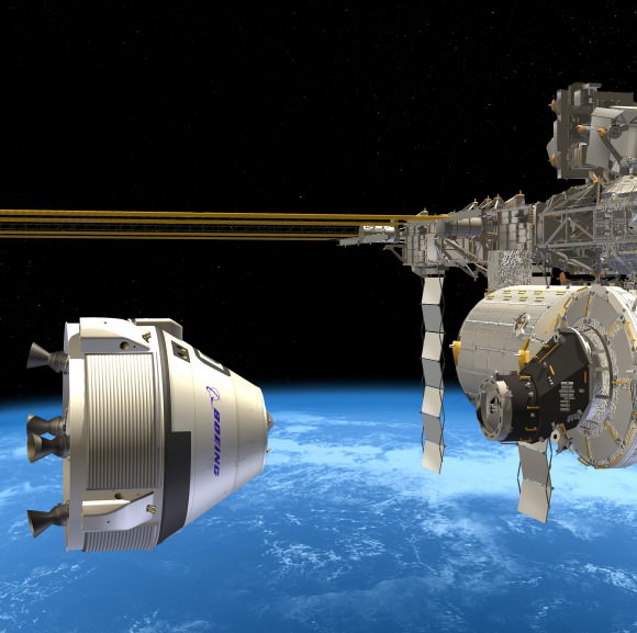
Boeing has moved considerably closer towards regaining America’s lost capability to launch humans to space when the firm’s privately built CST-100 crew capsule achieved two key new milestones on the path to blastoff from Florida’s Space Coast.

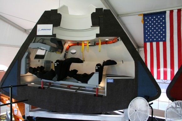
The CST-100 capsule is designed to carry a crew of up to 7 astronauts on missions to low-Earth orbit (LEO) and the International Space Station (ISS) around the middle of this decade.

Boeing CST-100 crew vehicle docks at the ISS. Credit: Boeing

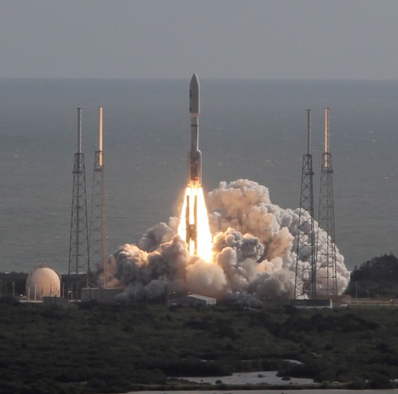
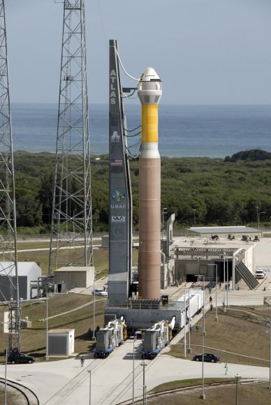
Boeing’s crew transporter will fly to space atop the venerable Atlas V rocket built by United Launch Alliance (ULA) from Launch Complex 41 on Cape Canaveral Air Force Station in Florida.

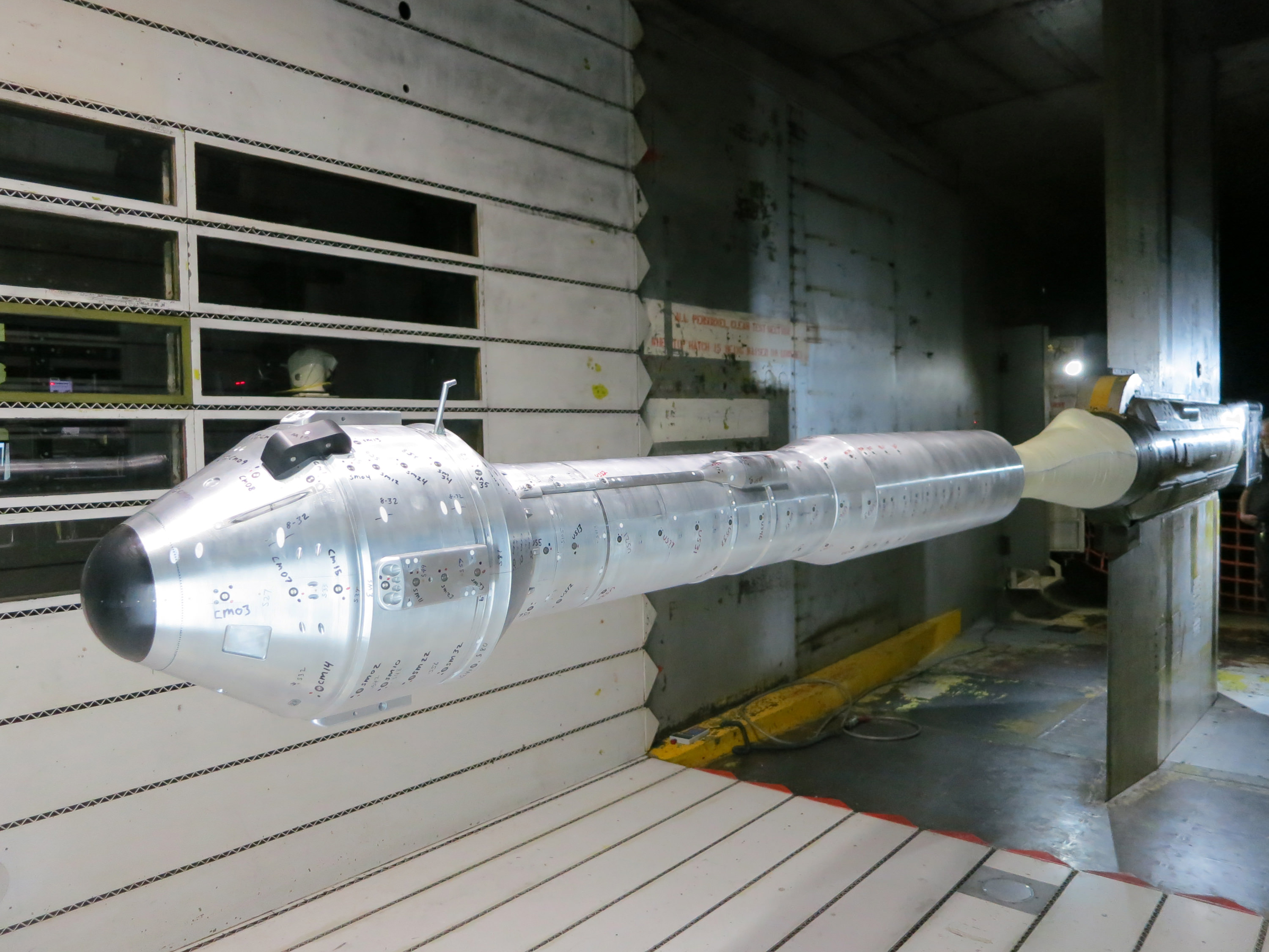
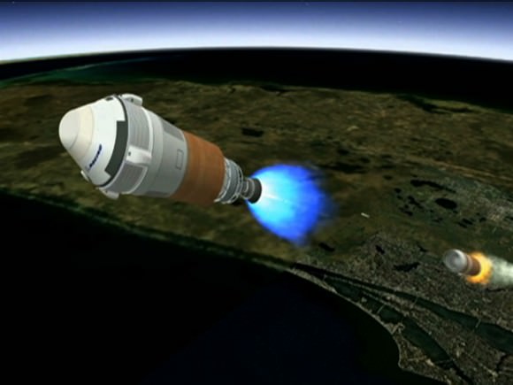
The Boeing and ULA teams recently completed the first wind tunnel tests of a 7 percent scale model of the integrated capsule and Atlas V rocket (photo above) as well as thrust tests of the modified Centaur upper stage.

The work is being done under the auspices of NASA’s Commercial Crew Integrated Capability (CCiCap) initiative, intended to make commercial human spaceflight services available for both US government and commercial customers, such as the proposed Bigelow Aerospace mini space station.

Boeing CST-100 capsule mock-up, interior view. Credit: Ken Kremer - kenkremer.com
Boeing CST-100 capsule mock-up, interior view. Credit: Ken Kremer – kenkremer.com

Since its maiden liftoff in 2002, the ULA Atlas V rocket has flawlessly launched numerous multi-billion dollar NASA planetary science missions like the Curiosity Mars rover, Juno Jupiter orbiter and New Horizons mission to Pluto as well as a plethora of top secret Air Force spy satellites.

But the two stage Atlas V has never before been used to launch humans to space – therefore necessitating rigorous testing and upgrades to qualify the entire vehicle and both stages to meet stringent human rating requirements.

“The Centaur has a long and storied past of launching the agency’s most successful spacecraft to other worlds,” said Ed Mango, NASA’s CCP manager at the agency’s Kennedy Space Center in Florida. “Because it has never been used for human spaceflight before, these tests are critical to ensuring a smooth and safe performance for the crew members who will be riding atop the human-rated Atlas V.”

The combined scale model CST-100 capsule and complete Atlas V rocket were evaluated for two months of testing this spring inside an 11- foot diameter transonic wind tunnel at NASA’s Ames Research Center in Moffett Field, Calif.

“The CST-100 and Atlas V, connected with the launch vehicle adaptor, performed exactly as expected and confirmed our expectations of how they will perform together in flight,” said John Mulholland, Boeing vice president and program manager for Commercial Programs.

Testing of the Centaur stage centered on characterizing the flow of liquid oxygen from the oxygen tank through the liquid oxygen-feed duct line into the pair of RL-10 engines where the propellant is mixed with liquid hydrogen and burned to create thrust to propel the CST-100 into orbit.

Boeing is aiming for an initial three day manned orbital test flight of the CST-100 during 2016, says Mulholland.

Artist's concept shows Boeing's CST-100 spacecraft separating from the first stage of its launch vehicle, a United Launch Alliance Atlas V rocket, following liftoff from Cape Canaveral Air Force Station in Florida. Credit: Boeing
Artist’s concept shows Boeing’s CST-100 spacecraft separating from the first stage of its launch vehicle, a United Launch Alliance Atlas V rocket, following liftoff from Cape Canaveral Air Force Station in Florida. Credit: Boeing

But that date is dependent on funding from NASA and could easily be delayed by the ongoing sequester which has slashed NASA’s and all Federal budgets.

Chris Ferguson, the commander of the final shuttle flight (STS-135) by Atlantis, is leading Boeing’s flight test effort.

Boeing has leased one of NASA’s Orbiter Processing Facility hangers (OPF-3) at the Kennedy Space Center (KSC) for the manufacturing and assembly of its CST-100 spacecraft.

Mulholland told me previously that Boeing will ‘cut metal’ soon. “Our first piece of flight design hardware will be delivered to KSC and OPF-3 around mid 2013.”

NASA’s CCP program is fostering the development of the CST-100 as well as the SpaceX Dragon and Sierra Nevada Dream Chaser to replace the crew capability of NASA’s space shuttle orbiters.

The Atlas V will also serve as the launcher for the Sierra Nevada Dream Chaser space taxi.

Since the forced retirement of NASA’s shuttle fleet in 2011, US and partner astronauts have been 100% reliant on the Russians to hitch a ride to the ISS aboard the Soyuz capsules – at a price tag exceeding $60 Million per seat.

Simultaneously on a parallel track NASA is developing the Orion crew capsule and SLS heavy lift booster to send humans to the Moon and deep space destinations including Asteroids and Mars.

And don’t forget to “Send Your Name to Mars” aboard NASA’s MAVEN orbiter- details here. Deadline: July 1, 2013

Ken Kremer

…………….
Learn more about Conjunctions, Mars, Curiosity, Opportunity, MAVEN, LADEE and NASA missions at Ken’s upcoming lecture presentations:

June 4: “Send your Name to Mars” and “CIBER Astro Sat, LADEE Lunar & Antares ISS Rocket Launches from Virginia”; Rodeway Inn, Chincoteague, VA, 8:30 PM

June 11: “Send your Name to Mars” and “LADEE Lunar & Antares ISS Rocket Launches from Virginia”; NJ State Museum Planetarium and Amateur Astronomers Association of Princeton (AAAP), Trenton, NJ, 730 PM.

June 12: “Send your Name to Mars” and “LADEE Lunar & Antares ISS Rocket Launches from Virginia”; Franklin Institute and Rittenhouse Astronomical Society, Philadelphia, PA, 8 PM.

NASA’s Curiosity Mars Science Laboratory  (MSL) rover blasts off for Mars atop a stunningly beautiful Atlas V  rocket on Nov. 26, 2011 at 10:02 a.m. EST from Cape Canaveral, Florida.   United Launch Alliance (ULA) is now upgrading the Atlas V to launch humans aboard the Boeing CST-100 and Sierra Nevada Dream Chaser space taxis. Credit: Ken Kremer - kenkremer.com
NASA’s Curiosity Mars Science Laboratory (MSL) rover blasts off for Mars atop a stunningly beautiful Atlas V rocket on Nov. 26, 2011 at 10:02 a.m. EST from Cape Canaveral, Florida. United Launch Alliance (ULA) is now upgrading the Atlas V to launch humans aboard the Boeing CST-100 and Sierra Nevada Dream Chaser space taxis. Credit: Ken Kremer – kenkremer.com
The CST-100 spacecraft awaits liftoff aboard an Atlas V launch vehicle in this artist's concept. Credit: Boeing
The CST-100 spacecraft awaits liftoff aboard an Atlas V launch vehicle in this artist’s concept. Credit: Boeing

Opportunity Discovers Clays Favorable to Martian Biology and Sets Sail for Motherlode of New Clues

Opportunity established a new American driving record for a vehicle on another world on May 15, 2013 (Sol 3309) and made history by driving ahead from this point at Cape York. This navcam mosaic shows the view forward to her next destinations of Solander Point and Cape Tribulation along the lengthy rim of huge Endeavour crater spanning 14 miles (22 km) in diameter. Opportunity discovered clay minerals at Cape York and stands as the most favorable location for Martian biology discovered during her entire nearly 10 year long mission to Mars. Credit: NASA/JPL/Cornell/Kenneth Kremer/Marco Di Lorenzo

NASA’s Opportunity Mars rover discovered clay minerals at Cape York ridge along the rim of Endeavour crater – seen in this photo mosaic – which stands as the most favorable location for Martian biology discovered during her entire nearly 10 year long mission to Mars. Opportunity also established a new American driving record for a vehicle on another world on May 15, 2013 (Sol 3309) and made history by driving ahead from this point at Cape York. This navcam photo mosaic shows the view forward to her next destinations of Solander Point and Cape Tribulation along the lengthy rim of huge Endeavour crater spanning 14 miles (22 km) in diameter.
Credit: NASA/JPL/Cornell/Ken Kremer (kenkremer.com)/Marco Di Lorenzo
Updated: Illustrated below with a collection of imagery, mosaics and route maps[/caption]

Now nearly a decade into her planned 3 month only expedition to Mars, NASA’s longest living rover Opportunity, struck gold and has just discovered the strongest evidence to date for an environment favorable to ancient Martian biology – and she has set sail hunting for a motherlode of new clues amongst fabulous looking terrain!!

Barely two weeks ago in mid-May 2013, Opportunity’s analysis of a new rock target named “Esperance” confirmed that it is composed of a “clay that had been intensely altered by relatively neutral pH water – representing the most favorable conditions for biology that Opportunity has yet seen in the rock histories it has encountered,” NASA said in a statement.

The finding of a fractured rock loaded with clay minerals and ravaged by flowing liquid water in which life could have thrived amounts to a scientific home run for the golf cart sized rover!

“Water that moved through fractures during this rock’s history would have provided more favorable conditions for biology than any other wet environment recorded in rocks Opportunity has seen,” said the mission’s principal investigator Prof. Steve Squyres of Cornell University, Ithaca, N.Y.

Opportunity accomplished the ground breaking new discovery by exposing the interior of Esperance with her still functioning Rock Abrasion Tool (RAT) and examining a pristine patch using the microscopic camera and X-Ray spectrometer on the end of her 3 foot long robotic arm.

The pale rock in the upper center of this image, about the size of a human forearm, includes a target called "Esperance," which was inspected by NASA's Mars Exploration Rover Opportunity. Data from the rover's alpha particle X-ray spectrometer (APXS) indicate that Esperance's composition is higher in aluminum and silica, and lower in calcium and iron, than other rocks Opportunity has examined in more than nine years on Mars. Preliminary interpretation points to clay mineral content due to intensive alteration by water. Credit: NASA/JPL-Caltech/Cornell/Arizona State Univ
The pale rock in the upper center of this image, about the size of a human forearm, includes a target called “Esperance,” which was inspected by NASA’s Mars Exploration Rover Opportunity. Data from the rover’s alpha particle X-ray spectrometer (APXS) indicate that Esperance’s composition is higher in aluminum and silica, and lower in calcium and iron, than other rocks Opportunity has examined in more than nine years on Mars. Preliminary interpretation points to clay mineral content due to intensive alteration by water. Credit: NASA/JPL-Caltech/Cornell/Arizona State Univ

The robot made the discovery at the conclusion of a 20 month long science expedition circling around a low ridge called “Cape York” – which she has just departed on a southerly heading trekking around the eroded rim of the huge crater named “Endeavour.”

“Esperance was so important, we committed several weeks to getting this one measurement of it, even though we knew the clock was ticking.”

Esperance stems from a time when the Red Planet was far warmer and wetter billions of years ago.

“What’s so special about Esperance is that there was enough water not only for reactions that produced clay minerals, but also enough to flush out ions set loose by those reactions, so that Opportunity can clearly see the alteration,” said Scott McLennan of the State University of New York, Stony Brook, a long-term planner for Opportunity’s science team.

Close-Up of 'Esperance' After Abrasion by Opportunity This mosaic of four frames shot by the microscopic imager on the robotic arm of NASA's Mars Exploration Rover Opportunity shows a rock target called "Esperance" after some of the rock's surface had been removed by Opportunity's rock abrasion tool, or RAT. The component images were taken on Sol 3305 on Mars (May 11, 2013). The area shown is about 2.4 inches (6 centimeters) across. Credit: NASA/JPL-Caltech/Cornell/USGS
Close-Up of ‘Esperance’ After Abrasion by Opportunity
This mosaic of four frames shot by the microscopic imager on the robotic arm of NASA’s Mars Exploration Rover Opportunity shows a rock target called “Esperance” after some of the rock’s surface had been removed by Opportunity’s rock abrasion tool, or RAT. The component images were taken on Sol 3305 on Mars (May 11, 2013). The area shown is about 2.4 inches (6 centimeters) across. Credit: NASA/JPL-Caltech/Cornell/USGS

Esperance is unlike any rock previously investigated by Opportunity; containing far more aluminum and silica which is indicative of clay minerals and lower levels of calcium and iron.

Most, but not all of the rocks inspected to date by Opportunity were formed in an environment of highly acidic water that is extremely harsh to most life forms.

Clay minerals typically form in potentially drinkable, neutral water that is not extremely acidic or basic.

Previously at Cape York, Opportunity had found another outcrop containing a small amount of clay minerals formed by exposure to water called “Whitewater Lake.”

“There appears to have been extensive, but weak, alteration of Whitewater Lake, but intense alteration of Esperance along fractures that provided conduits for fluid flow,” said Squyres.

Opportunity rover discovered phyllosilicate clay minerals and calcium sulfate veins at the bright outcrops of ‘Whitewater Lake’, at right, imaged by the Navcam camera on Sol 3197 (Jan. 20, 2013, coinciding with her 9th anniversary on Mars.  “Copper Cliff” is the dark outcrop, at top center. Darker “Kirkwood” outcrop, at left, is site of mysterious “newberries” concretions. This panoramic view was snapped from ‘Matijevic Hill’ on Cape York ridge at Endeavour Crater. Credit: NASA/JPL-Caltech/Cornell/Marco Di Lorenzo/Ken Kremer
Opportunity rover discovered phyllosilicate clay minerals and calcium sulfate veins at the bright outcrops of ‘Whitewater Lake’, at right, imaged by the Navcam camera on Sol 3197 (Jan. 20, 2013, coinciding with her 9th anniversary on Mars. “Copper Cliff” is the dark outcrop, at top center. Darker “Kirkwood” outcrop, at left, is site of mysterious “newberries” concretions. This panoramic view was snapped from ‘Matijevic Hill’ on Cape York ridge at Endeavour Crater. Credit: NASA/JPL-Caltech/Cornell/Marco Di Lorenzo/Ken Kremer

Cape York is a hilly segment of the rim of Endeavour crater which spans 14 miles (22 km) across – where the robot arrived in mid-2011 and will spend her remaining life.

Opportunity has now set sail for her next crater rim destination named “Solander Point”, an area about 1.4 miles (2.2 kilometers) away – due south from “Cape York.”

“Our next destination will be Solander Point,” Squyres told Universe Today.

Along the way, Opportunity will soon cross “Botany Bay” and “Sutherland Point”, last seen when Opportunity first arrived at Cape York.

Eventually she will continue further south to a rim segment named ‘Cape Tribulation’ which holds huge caches of clay minerals.

The rover must arrive at “Solander Point” before the onset of her 6th Martian winter so that she can be advantageously tilted along north facing slopes to soak up the maximum amount of sun by her power generating solar wings. She might pull up around August.

On the other side of Mars, Opportunity’s new sister rover Curiosity also recently discovered clay minerals on the floor of her landing site inside Gale Crater.

Curiosity found the clay minerals – and a habitat that could support life – after analyzing powdery drill tailings from the Yellowknife Bay basin worksite with her on board state-of-the-art chemistry labs.

Just a week ago on May 15 (Sol 3309), Opportunity broke through the 40 year old American distance driving record set back in December 1972 by Apollo 17 astronauts Eugene Cernan and Harrison Schmitt.

But she is not sitting still resting on her laurels!

This past week the robots handlers’ back on Earth put the pedal to the metal and pushed her forward another quarter mile during 5 additional drives over 7 Sols, or Martian days. Thus her total odometry since landing on 24 January 2004 now stands at 22.45 miles (36.14 kilometers).

Opportunity will blast through the world record milestone of 23 miles (37 kilometers) held by the Lunokhod 2 lunar rover (from the Soviet Union), somewhere along the path to “Solander Point” in the coming months.

Opportunity captures the eerie Martian scenery looking south across Botany Bay from the southern tip of Cape York to her next destination - Solander Point,  about 1 mile (1.6 km) away. This navcam photo mosaic was taken on Sol 3317, May  23, 2013.    Credit: NASA/JPL/Cornell//Marco Di Lorenzo/Ken Kremer (kenkremer.com)
Opportunity captures the eerie Martian scenery looking south across Botany Bay from the southern tip of Cape York to her next destination – Solander Point, about 1 mile (1.6 km) away. This navcam photo mosaic was taken on Sol 3317, May 23, 2013. Credit: NASA/JPL/Cornell//Marco Di Lorenzo/Ken Kremer (kenkremer.com)

Endeavour Crater features terrain with older rocks than previously inspected and unlike anything studied before by Opportunity. It’s a place no one ever dared dream of reaching prior to Opportunity’s launch in the summer of 2003 and landing on the Meridiani Planum region in 2004.

Signatures of clay minerals, or phyllosilicates, were detected at several spots at Endeavour’s western rim by observations from the Compact Reconnaissance Imaging Spectrometer for Mars (CRISM) aboard NASA’s Mars Reconnaissance Orbiter (MRO).

“The motherlode of clay minerals is on Cape Tribulation. The exposure extends all the way to the top, mainly on the inboard side,” says Ray Arvidson, the rover’s deputy principal investigator at Washington University in St. Louis.

Stay tuned for the continuing breathtaking adventures of NASA’s sister rovers Opportunity and Curiosity!

And don’t forget to “Send Your Name to Mars” aboard NASA’s MAVEN orbiter- details here. Deadline: July 1, 2013

Ken Kremer

…………….
Learn more about Mars, Curiosity, Opportunity, MAVEN, LADEE and NASA missions at Ken’s upcoming lecture presentations:

June 4: “Send your Name to Mars” and “CIBER Astro Sat, LADEE Lunar & Antares Rocket Launches from Virginia”; Rodeway Inn, Chincoteague, VA, 8:30 PM

June 11: “Send your Name to Mars” and “LADEE Lunar & Antares Rocket Launches from Virginia”; NJ State Museum Planetarium and Amateur Astronomers Association of Princeton (AAAP), Trenton, NJ, 8 PM.

June 12: “Send your Name to Mars” and “LADEE Lunar & Antares Rocket Launches from Virginia”; Franklin Institute and Rittenhouse Astronomical Society, Philadelphia, PA, 8 PM.

Traverse Map for NASA’s Opportunity rover from 2004 to 2013 to Record Setting Drive on May 15. This map shows the entire path the rover has driven during more than 9 years and over 3318 Sols, or Martian days, since landing inside Eagle Crater on Jan 24, 2004 to current location heading south to Solander Point from  Cape York ridge at the western rim of Endeavour Crater.  On May 15, 2013 Opportunity drove 263 feet (80 meters) southward - achieving a total traverse distance on Mars of 22.22 miles (35.76 kilometers) - and broke the driving record by any NASA vehicle that was previously held by the astronaut-driven Apollo 17 Lunar Rover in 1972. Credit: NASA/JPL/Cornell/ASU/Marco Di Lorenzo/Ken Kremer
Traverse Map for NASA’s Opportunity rover from 2004 to 2013 to Record Setting Drive on May 15. This map shows the entire path the rover has driven during more than 9 years and over 3318 Sols, or Martian days, since landing inside Eagle Crater on Jan 24, 2004 to current location heading south to Solander Point from Cape York ridge at the western rim of Endeavour Crater. On May 15, 2013 Opportunity drove 263 feet (80 meters) southward – achieving a total traverse distance on Mars of 22.22 miles (35.76 kilometers) – and broke the driving record by any NASA vehicle that was previously held by the astronaut-driven Apollo 17 Lunar Rover in 1972. Credit: NASA/JPL/Cornell/ASU/Marco Di Lorenzo/Ken Kremer
Opportunity Heads Toward Next Destination, 'Solander Point' This map of a portion of the western rim of Endeavour Crater on Mars shows the area where NASA's Mars Exploration Rover Opportunity worked for 20 months, "Cape York," in relation to the area where the rover team plans for Opportunity to spend its sixth Martian winter, "Solander Point." Credit: NASA/JPL-Caltech/Univ. of Arizona
Opportunity Heads Toward Next Destination, ‘Solander Point’
-This map of a portion of the western rim of Endeavour Crater on Mars shows the area where NASA’s Mars Exploration Rover Opportunity worked for 20 months, “Cape York,” in relation to the area where the rover team plans for Opportunity to spend its sixth Martian winter, “Solander Point.” Credit: NASA/JPL-Caltech/Univ. of Arizona

Curiosity Drills 2nd Hole into Ancient Mars Rocks Searching for the Ingredients of Life

This time lapse mosaic shows Curiosity moving her robotic arm to drill into her 2nd rockt target named “Cumberland” to collect powdery material on May 19, 2013 (Sol 279) for analysis by her onboard chemistry labs; SAM & Chemin. The photomosaic was stitched from raw images captured by the navcam cameras on May 14 & May 19 (Sols 274 & 279). Credit: NASA/JPL-Caltech/Ken Kremer/Marco Di Lorenzo

NASA’s Curiosity rover has just successfully bored inside ancient rocks on Mars for only the 2nd time since her nail biting landing in August 2012 inside Gale Crater as she searches for the ingredients of life.

On Sunday, May 20, the rover drilled about 2.6 inches (6.6 centimeters) deep into a target named “Cumberland” to collect powdery samples from the rock’s interior that hold the secrets to the history of water and habitability on the Red Planet.

“Cumberland” is literally just a stone’s throw away from the first drill target named “John Klein” where Curiosity bored the historic first drill hole on an alien world three months ago in February.

NASA's Mars rover Curiosity drilled into this rock target, "Cumberland," during the 279th Martian day, or sol, of the rover's work on Mars (May 19, 2013) and collected a powdered sample of material from the rock's interior. Analysis of the Cumberland sample using laboratory instruments inside Curiosity will check results from "John Klein," the first rock on Mars from which a sample was ever collected and analyzed. The two rocks have similar appearance and lie about nine feet (2.75 meters) apart. Image Credit: NASA/JPL-Caltech/MSSS
NASA’s Mars rover Curiosity drilled into this rock target, “Cumberland,” during the 279th Martian day, or sol, of the rover’s work on Mars (May 19, 2013) and collected a powdered sample of material from the rock’s interior. Analysis of the Cumberland sample using laboratory instruments inside Curiosity will check results from “John Klein,” the first rock on Mars from which a sample was ever collected and analyzed. The two rocks have similar appearance and lie about nine feet (2.75 meters) apart. Image Credit: NASA/JPL-Caltech/MSSS

Analysis of the gray colored, powdery “John Klein” sample by Curiosity’s pair of onboard chemistry labs – SAM & Chemin – revealed that this location on Mars was habitable in the past and possesses the key chemical ingredients required to support microbial life forms – thereby successfully accomplishing the key science objective of the mission and making a historic discovery.

The Cumberland powder will be fed into SAM and Chemin shortly through a trio of inlet ports on the rover deck.

‘Cumberland’ lies about nine feet (2.75 meters) west of ‘John Klein’. Both targets are inside the shallow depression named ‘Yellowknife Bay’ where Curiosity has been exploring since late 2012.

The six wheeled NASA robot arrived at Cumberland just last week on May 14 (Sol 274) after a pair of short drives.

6 Wheels on Mars at “Cumberland” drill target is shown in this photo mosaic of Curiosity’s underbelly snapped on May 15, 2013 (Sol 275) after the rover drove about 9 feet (2.75 m) from the John Klein outcrop inside Yellowknife Bay. Credit: NASA/JPL-Caltech/Ken Kremer/Marco Di Lorenzo

The science team directed Curiosity to drill into ‘Cumberland’ to determine if it possesses the same ingredients found at “John Klein” and whether the habitable environment here is widespread and how long it existed in Mars’ history.

“We’ll drill another hole [at Cumberland] to confirm what we found in the John Klein hole,” said John Grotzinger to Universe Today. Grotzinger, of the California Institute of Technology in Pasadena, Calif., leads NASA’s Curiosity Mars Science Laboratory mission.

“The favorable conditions included the key elemental ingredients for life, an energy gradient that could be exploited by microbes, and water that was not harshly acidic or briny,” NASA said in a statement.

Panoramic view of Yellowknife Bay basin back dropped by Mount Sharp shows the location of the first two drill sites - John Klein & Cumberland - targeted by NASA’s Curiosity Mars rover.  Curiosity accomplished historic 1st drilling into Martian rock at John Klein outcrop on Feb 8, 2013 (Sol 182) near where the robotic arm is touching the surface.  This week the rover scooted about 9 feet to the right to Cumberland (right of center) for 2nd drill campaign in late-May 2013.  Credit: NASA/JPL-Caltech/Ken Kremer/Marco Di Lorenzo
Panoramic view of Yellowknife Bay basin back dropped by Mount Sharp shows the location of the first two drill sites – John Klein & Cumberland – targeted by NASA’s Curiosity Mars rover. Curiosity accomplished historic 1st drilling into Martian rock at John Klein outcrop on Feb 8, 2013 (Sol 182) near where the robotic arm is touching the surface. This week the rover scooted about 9 feet to the right to Cumberland (right of center) for 2nd drill campaign on May 19, 2013 (Sol 279). Credit: NASA/JPL-Caltech/Ken Kremer/Marco Di Lorenzo

‘Cumberland’ and ‘John Klein’ are patches of flat-lying bedrock shot through with pale colored hydrated mineral veins composed of calcium sulfate and featuring a bumpy surface texture inside the ‘Yellowknife Bay’ basin that resembles a dried out lake bed.

“We have found a habitable environment [at John Klein] which is so benign and supportive of life that probably if this water was around, and you had been on the planet, you would have been able to drink it,” said Grotzinger.

Curiosity will remain at Cumberland for several weeks to fully characterize the area and then continue exploring several additional outcrops in and around Yellowknife Bay.

“After that we’re likely to begin the trek to Mt. Sharp, though we’ll stop quickly to look at a few outcrops that we passed by on the way into Yellowknife Bay,” Grotzinger told me.

One stop is likely to include the ‘Shaler’ outcrop of cross-bedding that was briefly inspected on the way in.

Thereafter the 1 ton rover will resume her epic trek to the lower reaches of mysterious Mount Sharp, the 3.5 mile (5.5 km) high layered mountain that dominates her landing site and is the ultimate driving goal inside Gale Crater.

And don’t forget to “Send Your Name to Mars” aboard NASA’s MAVEN orbiter- details here. Deadline: July 1, 2013

Ken Kremer

…………….
Learn more about Mars, Curiosity, Opportunity, MAVEN, LADEE and NASA missions at Ken’s upcoming lecture presentations:

June 4: “Send your Name to Mars” and “CIBER Astro Sat, LADEE Lunar & Antares Rocket Launches from Virginia”; Rodeway Inn, Chincoteague, VA, 8:30 PM

June 11: “Send your Name to Mars” and “LADEE Lunar & Antares Rocket Launches from Virginia”; NJ State Museum Planetarium and Amateur Astronomers Association of Princeton (AAAP), Trenton, NJ, 8 PM.

June 12: “Send your Name to Mars” and “LADEE Lunar & Antares Rocket Launches from Virginia”; Franklin Institute and Rittenhouse Astronomical Society, Philadelphia, PA, 8 PM.


Video Caption: This JPL video shows the complicated choreography to get drill samples to Curiosity’s science instruments after completing 2nd drill campaign at “Cumberland.”

Send Your Name and a Haiku Poem to Mars on a Solar Winged MAVEN

The MAVEN missions ‘Going to Mars’ campaign invites the public to submit names and poems which will be included on a special DVD. The DVD will be adhered to the MAVEN spacecraft and launched to Mars on Nov. 18, 2013. Credit: NASA/GSFC

Do you want to go to Mars?

Well here’s your chance to get connected for a double barreled dose of Red Planet adventure courtesy of MAVEN – NASA’s next ‘Mission to Mars’ which is due to liftoff this November from the Florida Space Coast.

For a limited time only, NASA is offering the general public two cool ways to get involved and ‘Go to Mars’ aboard a DVD flying on the solar winged MAVEN (Mars Atmosphere and Volatile Evolution) orbiter.

You can send your name and a short poetic message to Mars via the ‘Going to Mars’ campaign being managed by the University of Colorado at Boulder’s Laboratory for Atmospheric and Space Physics (CU/LASP).

“Anybody on planet Earth is welcome to participate!” says NASA.

“The Going to Mars campaign offers people worldwide a way to make a personal connection to space, space exploration, and science in general, and share in our excitement about the MAVEN mission,” said Stephanie Renfrow, lead for the MAVEN Education and Public Outreach program at CU/LASP.

Signing up to send your name is easy. Simply click on the MAVEN mission website – here.

The MAVEN missions ‘Going to Mars’ campaign invites submissions from the public; artwork, messages, and names will be included on a special DVD. The DVD will be adhered to the MAVEN spacecraft and launched into orbit around Mars. (Courtesy Lockheed Martin)

Everyone who submits their name will be included on a DVD that will be attached to the winged orbiter. And you can print out a beautiful certificate of participation emblazoned with your name!

Over 1 million folks signed up to send their names to Mars with NASA’s Curiosity rover. So they are all riding along as Curiosity continues making ground breaking science discoveries and already found habitats that could support potential Martian microbes.

Writing the haiku poem will require thought, inspiration and creativity and involves a public contest – because only 3 poems will be selected and sent to Mars. The public will vote for the three winning entries.

Haiku’s are three line poems. The rules state that “the first and last lines must have exactly five syllables each and the middle line must have exactly seven syllables. All messages must be original and not plagiarized in any way.”

The complete contest rules are found at the mission website – here:

This is a simple way for kids and adults alike to participate in humanity’s exploration of the Red Planet. And it’s also a great STEM activity for educators and school kids of all ages before this year’s school season comes to a close.

470505_10150721848592868_1231281550_o[1]

“This new campaign is a great opportunity to reach the next generation of explorers and excite them about science, technology, engineering and math,” said Bruce Jakosky, MAVEN principal investigator from CU/LASP. “I look forward to sharing our science with the worldwide community as MAVEN begins to piece together what happened to the Red Planet’s atmosphere.”

MAVEN is slated to blast off atop an Atlas V rocket from Cape Canaveral Florida on Nov. 18, 2013. It will join NASA’s armada of four robotic spacecraft when it arrives at Mars during 2014.

MAVEN is the first spacecraft devoted to exploring and understanding the Martian upper atmosphere. The spacecraft will investigate how the loss of Mars’ atmosphere to space determined the history of water on the surface.

But don’t dawdle- the deadline for submissions is July 1.

So, sign up to ‘Go to Mars’ – and do it NOW!

Juice up your inner poet and post your ‘Haiku’ here – if you dare

Ken Kremer

Mars Armada Resumes Contact with NASA – Ready to Rock ‘n Roll n’ Drill

Curiosity accomplished historic 1st drilling into Martian rock at John Klein outcrop on Feb 8, 2013 (Sol 182), shown in this context mosaic view of the Yellowknife Bay basin taken on Jan. 26 (Sol 169) - back dropped with Mount Sharp - where the robot is currently working. Curiosity will bore a 2nd drill hole soon following the resumption of contact with the end of the solar conjunction period. Credit: NASA/JPL-Caltech/Ken Kremer/Marco Di Lorenzo

Curiosity accomplished historic 1st drilling into Martian rock at John Klein outcrop on Feb 8, 2013 (Sol 182), shown in this context mosaic view of the Yellowknife Bay basin taken on Jan. 26 (Sol 169) – back dropped with Mount Sharp – where the robot is currently working. Curiosity will bore a 2nd drill hole soon following the resumption of contact with the end of the solar conjunction period. Credit: NASA/JPL-Caltech/Ken Kremer/Marco Di Lorenzo
See drill hole and conjunction videos below[/caption]

After taking a well deserved and unavoidable break during April’s solar conjunction with Mars that blocked two way communication with Earth, NASA’s powerful Martian fleet of orbiters and rovers have reestablished contact and are alive and well and ready to Rock ‘n Roll ‘n Drill.

“Both orbiters and both rovers are in good health after conjunction,” said NASA JPL spokesman Guy Webster exclusively to Universe Today.

Curiosity’s Chief Scientist John Grotzinger confirmed to me today (May 1) that further drilling around the site of the initial John Klein outcrop bore hole is a top near term priority.

The goal is to search for the chemical ingredients of life.

“We’ll drill a second sample,” Grotzinger told Universe Today exclusively. Grotzinger, of the California Institute of Technology in Pasadena, Calif., leads NASA’s Curiosity Mars Science Laboratory mission.

“We’ll move a small bit, either with the arm or the wheels, and then drill another hole to confirm what we found in the John Klein hole.”

Earth, Mars and the Sun have been lined up in nearly a straight line for the past several weeks, which effectively blocked virtually all contact with NASA’s four pronged investigative Armada at the Red Planet.

NASA’s Red Planet fleet consists of the Curiosity (MSL) and Opportunity (MER) surface rovers as well as the long lived Mars Odyssey (MO) and Mars Reconnaissance Orbiter (MRO) robotic orbiters circling overhead. ESA’s Mars Express orbiter is also exploring the Red Planet.

“All have been in communications,” Webster told me today, May 1.

The NASA spacecraft are functioning normally and beginning to transmit the science data collected and stored in on board memory during the conjunction period when a commanding moratorium was in effect.

“Lots of data that had been stored on MRO during conjunction has been downlinked,” Webster confirmed to Universe Today.

Curiosity and Mount Sharp: Curiosity's elevated robotic arm and drill are staring back at you - back dropped by Mount Sharp, her ultimate destination.  The rover team anticipates new science discoveries following the resumption of contact with NASA after the end of solar conjunction.  This panoramic vista of Yellowknife Bay basin was snapped on March 23, Sol 223 prior to conjunction and assembled from several dozen raw images snapped by the rover's navigation camera system.  These images were snapped after the robot recovered from a computer glitch in late Feb and indicated she was back alive and functioning working normally. Credit: NASA/JPL-Caltech/Marco Di Lorenzo/KenKremer (kenkremer.com).
Curiosity and Mount Sharp: Curiosity’s elevated robotic arm and drill stare back at you at the John Klein drill site – back dropped by mysterious Mount Sharp. The rover has resumed contact with NASA following the end of solar conjunction. This panoramic vista was snapped on March 23, 2013, Sol 223. Credit: NASA/JPL-Caltech/Marco Di Lorenzo/KenKremer (kenkremer.com)

And NASA is already transmitting and issuing new marching orders to the Martian Armada to resume their investigations into unveiling the mysteries of the Red Planet and determine whether life ever existed eons ago or today.

“New commanding, post-conjunction has been sent to both orbiters and Opportunity.”

“And the sequence is being developed today for sending to Curiosity tonight (May 1), as scheduled more than a month ago,” Webster explained.

“We’ll spend the next few sols transitioning over to new flight software that gives the rover additional capabilities,” said Grotzinger.

“After that we’ll spend some time testing out the science instruments on the B-side rover compute element – that we booted to before conjunction.”

Curiosity is at work inside the Yellowknife Bay basin just south of the Martian equator. Opportunity is exploring the rim of Endeavour crater at the Cape York rim segment.

Opportunity Celebrates 9 Years and 3200 Sols on Mars snapping this panoramic view from her current location on ‘Matijevic Hill’ at Endeavour Crater. The rover discovered phyllosilicate clay minerals and calcium sulfate veins at the bright outcrops of ‘Whitewater Lake’, at right, imaged by the Navcam camera on Sol 3197 (Jan. 20, 2013). “Copper Cliff” is the dark outcrop, at top center. Darker “Kirkwood” outcrop, at left, is site of mysterious “newberries” concretions. Credit: NASA/JPL-Caltech/Cornell/Marco Di Lorenzo/Ken Kremer

Mars Solar Conjunction is a normal celestial event that occurs naturally about every 26 months. The science and engineering teams take painstaking preparatory efforts to insure no harm comes to the spacecraft during the conjunction period when they have no chance to assess or intervene in case problems arise.

So it’s great news and a huge relief to the large science and operations teams handling NASA’s Martian assets to learn that all is well.

Since the sun can disrupt and garble communications, mission controllers suspended transmissions and commands so as not to inadvertently create serious problems that could damage the fleet in a worst case scenario.

So what’s on tap for Curiosity and Opportunity in the near term ?

“For the first few days for Curiosity we will be installing a software upgrade.”

“For both rovers, the science teams will be making decisions about how much more to do at current locations before moving on,” Webster told me.

The Opportunity science team has said that the long lived robot has pretty much finished investigating the Cape York area at Endeavour crater where she made the fantastic discovery of phyllosilicates clay minerals that form in neutral water.

Signals from Opportunity received a few days ago on April 27 indicated that the robot had briefly entered a standby auto mode while collecting imagery of the sun.

NASA reported today that all operations with Opportunity was “back under ground control, executing a sequence of commands sent by the rover team”, had returned to normal and the robot exited the precautionary status.

Opportunity Celebrates 9 Years on Mars snapping this panoramic view of the vast expanse of 14 mile (22 km) wide Endeavour Crater from atop ‘Matijevic Hill’ on Sol 3182 (Jan. 5, 2013). The rover then drove 43 feet to arrive at ‘Whitewater Lake’ and investigate clay minerals. Photo mosaic was stitched from Navcam images and colorized. Credit: NASA/JPL-Caltech/Cornell/Ken Kremer/Marco Di Lorenzo

“The Curiosity team has said they want to do at least one more drilling in Yellowknife Bay area,” according to Webster.

Curiosity has already accomplished her primary task and discovered a habitable zone that possesses the key ingredients needed for potential alien microbes to once have thrived in the distant past on the Red Planet when it was warmer and wetter.

The robot found widespread evidence for repeated episodes of flowing liquid water, hydrated mineral veins and phyllosilicates clay minerals on the floor of her Gale Crater landing site after analyzing the first powder ever drilled from a Martian rock.

Video Caption: Historic 1st bore hole drilled by NASA’s Curiosity Mars rover on Sol 182 of the mission (8 Feb 2013). Credit: NASA/JPL-Caltech/MSSS/Marco Di Lorenzo/Ken Kremer (http://www.kenkremer.com/)

During conjunction Curiosity collected weather, radiation and water measurements but no imagery.

Check out this wonderful new story at Space.com featuring Curiosity mosaics by me and my imaging partner Marco Di Lorenzo and an interview with me.

Ken Kremer

Curiosity Rover snapped this self portrait mosaic with the MAHLI camera while sitting on flat sedimentary rocks at the “John Klein” outcrop where the robot conducted historic first sample drilling inside the Yellowknife Bay basin, on Feb. 8 (Sol 182) at lower left in front of rover. The photo mosaic was stitched from raw images snapped on Sol 177, or Feb 3, 2013, by the robotic arm camera - accounting for foreground camera distortion. Credit: NASA/JPL-Caltech/MSSS/Marco Di Lorenzo/KenKremer (kenkremer.com).
Curiosity Rover snapped this self portrait mosaic with the MAHLI camera while sitting on flat sedimentary rocks at the “John Klein” outcrop where the robot conducted historic first sample drilling inside the Yellowknife Bay basin, on Feb. 8 (Sol 182) at lower left in front of rover. The photo mosaic was stitched from raw images snapped on Sol 177, or Feb 3, 2013, by the robotic arm camera – accounting for foreground camera distortion. Credit: NASA/JPL-Caltech/MSSS/Marco Di Lorenzo/KenKremer (kenkremer.com).

Watch this brief NASA JPL video for an explanation of Mars Solar Conjunction.

More Evidence That Mars Lost Its Atmosphere

Mosaic self-portrait of Curiosity at the John Klein outcrop on Feb. 3, 2013 (NASA/JPL-Caltech/MSSS)

Although today Mars’ atmosphere is sparse and thin — barely 1% the density of Earth’s at sea level — scientists don’t believe that was always the case. The Red Planet likely had a much denser atmosphere similar to ours, long, long ago. So… what happened to it?

NASA’s Curiosity rover has now found strong evidence that Mars lost much of its atmosphere to space — just as many scientists have suspected. The findings were announced today at the EGU 2013 General Assembly in Vienna.

Curiosity's SAM instrument (NASA/JPL-Caltech)
Curiosity’s SAM instrument (NASA/JPL-Caltech)

Curiosity’s microwave oven-sized Sample Analysis at Mars (SAM) instrument analyzed an atmosphere sample last week using a process that concentrates selected gases. The results provided the most precise measurements ever made of isotopes of argon in the Martian atmosphere.

Isotopes are variants of the same element with different atomic weights.

“We found arguably the clearest and most robust signature of atmospheric loss on Mars,” said Sushil Atreya, a SAM co-investigator at the University of Michigan.

SAM found that the Martian atmosphere has about four times as much of a lighter stable isotope (argon-36) compared to a heavier one (argon-38). This ratio is much lower than the Solar System’s original ratio, as estimated from measurements of the Sun and Jupiter.

The argon isotope fractionation provides clear evidence of the loss of atmosphere from Mars. (NASA/JPL)

This also removes previous uncertainty about the ratio in the Martian atmosphere in measurements from NASA’s Viking project in 1976, as well as from small volumes of argon extracted from Martian meteorites retrieved here on Earth.

These findings point to a process that favored loss of the lighter isotope over the heavier one, likely through gas escaping from the top of the atmosphere. This appears to be in line with a previously-suggested process called sputtering, by which atoms are knocked out of the upper atmosphere by energetic particles in the solar wind.

The solar wind may have helped strip Mars of its atmosphere over the course of many hundreds of millions of years (NASA)

Lacking a strong magnetic field, Mars’ atmosphere would have been extremely susceptible to atmospheric erosion by sputtering billions of years ago, when the solar wind was an estimated 300 times the density it is today.

These findings by Curiosity and SAM will undoubtedly support those made by NASA’s upcoming MAVEN mission, which will determine how much of the Martian atmosphere has been lost over time by measuring the current rate of escape to space. Scheduled to launch in November, MAVEN will be the first mission devoted to understanding Mars’ upper atmosphere.

Find out more about MAVEN and how Mars may have lost its atmosphere in the video below, and follow the most recent discoveries of the MSL mission here.

Source: NASA/JPL

Terran Fleet at Mars Takes a Break for Conjunction – Enjoy the Video and Parting View

Curiosity and Mount Sharp - Parting Shot ahead of Solar Conjunction. Enjoy this parting view of Curiosity's elevated robotic arm and drill are staring at you - back dropped with her ultimate destination - Mount Sharp - in this panoramic vista of Yellowknife Bay basin snapped on March 23, Sol 223, by the rover's navigation camera system. The raw images were stitched by Marco Di Lorenzo and Ken Kremer and colorized. Credit: NASA/JPL-Caltech/Marco Di Lorenzo/KenKremer (kenkremer.com). See video below explaining Mars Solar Conjunction

Curiosity and Mount Sharp – Parting Shot ahead of Mars Solar Conjunction
Enjoy this parting view of Curiosity’s elevated robotic arm and drill staring at you; back dropped with her ultimate destination – Mount Sharp – in this panoramic vista of Yellowknife Bay basin snapped on March 23, Sol 223, by the rover’s navigation camera system. The raw images were stitched by Marco Di Lorenzo and Ken Kremer and colorized. Credit: NASA/JPL-Caltech/Marco Di Lorenzo/KenKremer (kenkremer.com)
See video below explaining Mars Solar Conjunction[/caption]

Earth’s science invasion fleet at Mars is taking a break from speaking with their handlers back on Earth.

Why ? Because as happens every 26 months, the sun has gotten directly in the way of Mars and Earth.

Earth, Mars and the Sun are lined up in nearly a straight line. The geometry is normal and it’s called ‘Mars Solar Conjunction’.

Conjunction officially started on April 4 and lasts until around May 1.

From our perspective here on Earth, Mars will be passing behind the Sun.

Watch this brief NASA JPL video for an explanation of Mars Solar Conjunction.

Therefore the Terran fleet will be on its own for the next month since the sun will be blocking nearly all communications.

In fact since the sun can disrupt and garble communications, mission controllers will be pretty much suspending transmissions and commands so as not to inadvertently create serious problems that could damage the fleet in a worst case scenario.

Right now there are a trio of orbiters and a duo of rovers from NASA and ESA exploring Mars.

The spacecraft include the Curiosity (MSL) and Opportunity (MER) rovers from NASA. Also the Mars Express orbiter from ESA and the Mars Odyssey (MO) and Mars Reconnaissance Orbiter (MRO) from NASA.

Geometry of Mars Solar Conjunction

Because several of these robotic assets have been at Mars for nearly 10 years and longer, the engineering teams have a lot of experience with handling them during the month long conjunction period.

“This is our sixth conjunction for Odyssey,” said Chris Potts of JPL, mission manager for NASA’s Mars Odyssey, which has been orbiting Mars since 2001. “We have plenty of useful experience dealing with them, though each conjunction is a little different.”

But there is something new this go round.

“The biggest difference for this 2013 conjunction is having Curiosity on Mars,” Potts said. Odyssey and the Mars Reconnaissance Orbiter relay almost all data coming from Curiosity and the Mars Exploration Rover Opportunity, as well as conducting the orbiters’ own science observations.

The rovers and orbiters can continue working and collecting science images and spectral data.

But that data will all be stored in the on board memory for a post-conjunction playback starting sometime in May.

Ken Kremer

…………….

Learn more about Curiosity’s groundbreaking discoveries and NASA missions at Ken’s upcoming lecture presentations:

April 20/21 : “Curiosity and the Search for Life on Mars – (in 3-D)”. Plus Orion, SpaceX, Antares, the Space Shuttle and more! NEAF Astronomy Forum, Suffern, NY

April 28: “Curiosity and the Search for Life on Mars – (in 3-D)”. Plus the Space Shuttle, SpaceX, Antares, Orion and more. Washington Crossing State Park, Titusville, NJ, 130 PM

Curiosity is Back! Snapping Fresh Martian Vistas

Curiosity's raised robotic arm and drill are staring at you in this new panoramic vista of Yellowknife Bay basin snapped on March 23, Sol 223 by the rover's navigation camera system. The raw images were stitched by Marco Di Lorenzo and Ken Kremer and colorized. Credit: NASA/JPL-Caltech/Marco Di Lorenzo/KenKremer (kenkremer.com)

Curiosity is back! After a multi-week hiatus forced by a computer memory glitch, NASA’s mega rover is back to full operation.

And the proof is crystal clear in the beautiful new panoramic view (above) snapped by Curiosity this weekend from Yellowknife Bay, showing the robot’s arm and drill elevated and aiming straight at you – raring to go and ready to feast on something deliciously Martian.

“That drill is hungry, looking for something tasty to eat, and ‘you’ (loaded with water and organics) are it,” I thought with a chuckle as Curiosity seeks additional habitats and ingredients friendly to life.

So my imaging partner Marco Di Lorenzo and I celebrated the great news by quickly creating the new panoramic mosaic assembled from images taken on Saturday, March 23, or Sol 223, by the robot’s navigation cameras. Our new Curiosity mosaic was first featured on Saturday at NBC News Cosmic Log by Alan Boyle – while I was hunting for Comet Pan-STARRS.

So the fact that Curiosity is again snapping images and transmitting fresh alien vistas and new science data is a relief to eagerly waiting scientists and engineers here on Earth.

Drilling goes to the heart of the mission. It was absolutely essential to the key finding of Curiosity’s Martian foray thus far – that Mars possesses an environment where alien microbes could once have thrived in the distant past when the Red Planet was warmer and wetter.

Curiosity accomplished Historic 1st drilling into Martian rock at John Klein outcrop on Feb 8, 2013 (Sol 182), shown in this context mosaic view of the Yellowknife Bay basin taken on Jan. 26 (Sol 169) where the robot is currently working. The robotic arm is pressing down on the surface at John Klein outcrop of veined hydrated minerals – dramatically back dropped with her ultimate destination; Mount Sharp. Credit: NASA/JPL-Caltech/Ken Kremer/Marco Di Lorenzo

Curiosity has found widespread evidence for repeated episodes of flowing liquid water on the floor of her Gale Crater landing site – an essential prerequisite to life as we know it.

After coring and analyzing the first powder ever drilled from the interior of a Martian rock in February 2013, NASA’s Curiosity robot discovered some of the key chemical ingredients necessary to support life on early Mars billions of years ago.

Curiosity found that the fine-grained, sedimentary mudstone rock at the rovers current worksite inside the Yellowknife Bay basin possesses significant amounts of phyllosilicate clay minerals; indicating the flow of nearly neutral liquid water and a habitat friendly to the possible origin of simple Martian life forms eons ago.

Curiosity's First Sample Drilling hole is shown at the center of this image in a rock called "John Klein" on Feb. 8, 2013, or Sol 182 operations. The image was obtained by Curiosity’s Mars Hand Lens Imager (MAHLI). The sample-collection hole is 0.63 inch (1.6 centimeters) in diameter and 2.5 inches (6.4 centimeters) deep. The “mini drill” test hole near it is the same diameter, with a depth of 0.8 inch (2 centimeters). Credit: NASA/JPL-Caltech/MSSS
Curiosity’s First Sample Drilling hole is shown at the center of this image in a rock called “John Klein” on Feb. 8, 2013, or Sol 182 operations. The image was obtained by Curiosity’s Mars Hand Lens Imager (MAHLI). The sample-collection hole is 0.63 inch (1.6 centimeters) in diameter and 2.5 inches (6.4 centimeters) deep. The “mini drill” test hole near it is the same diameter, with a depth of 0.8 inch (2 centimeters). Credit: NASA/JPL-Caltech/MSSS

The rovers 7 foot (2.1 meter) long robotic arm fed aspirin sized samples of the gray, pulverized powder into the miniaturized CheMin and SAM analytical instruments on Feb. 22 and 23, or Sols 195 and 196. The samples were analyzed on Sol 200 and then the rover experienced her first significant problems since landing on Aug. 5, 2012.

The Chemistry and Mineralogy (CheMin) instrument and Sample Analysis at Mars (SAM) instruments test the Martian soil and rock samples to determine their chemical composition and search for traces of organic molecules – the building blocks of life

No organics have been found thus far.

The rover’s science mission has been on hold for nearly a month since “a memory glitch on the A-side computer on Feb. 27, which prompted controllers to command a swap from the A-side computer to the B-side computer,” according to a NASA statement.

“That operator-commanded swap put Curiosity into safe mode for two days. The rover team restored the availability of the A-side as a backup and prepared the B-side to resume full operations.”

The memory issue may have been caused by a cosmic ray strike. The rover suffered another minor setback last week, briefly reentering ‘safe mode’. And in between, a solar storm forced the team to shut Curiosity down for a few more days.

All appears well now.

The next step is to reanalyze those 1st gray rock tailings to continue the hunt for traces of organic molecules.

But the next solar conjunction will interrupt communications starting around April 4 for several weeks. More on that shortly.

After conjunction, Curiosity will resume her drilling campaign

Ken Kremer

…………….

Learn more about Curiosity’s groundbreaking discoveries and NASA missions at Ken’s upcoming lecture presentations:

April 20/21 : “Curiosity and the Search for Life on Mars – (in 3-D)”. Plus Orion, SpaceX, Antares, the Space Shuttle and more! NEAF Astronomy Forum, Suffern, NY

April 28: “Curiosity and the Search for Life on Mars – (in 3-D)”. Washington Crossing State Park, Titusville, NJ, 130 PM

Rover self portrait MAHLI mosaic taken this week has Curiosity sitting on the flat rocks of the “John Klein” drilling target area within the Yellowknife Bay depression. Note gradual rise behind rover. Credit: NASA/JPL-Caltech/MSSS/Marco Di Lorenzo/www.KenKremer.com.
Rover self portrait MAHLI mosaic taken this week has Curiosity sitting on the flat rocks of the “John Klein” drilling target area within the Yellowknife Bay depression. Note gradual rise behind rover. Credit: NASA/JPL-Caltech/MSSS/Marco Di Lorenzo/Ken Kremer (kenkremer.com)

Curiosity Once Again in Safe Mode – If Only Briefly

Not even two and a half weeks after a memory glitch that sent NASA’s Curiosity rover into a safe mode on Feb. 27, the robotic Mars explorer once again went into standby status as the result of a software discrepancy — although mission engineers diagnosed the new problem quickly and anticipate having the rover out of safe mode in a couple of days.

“This is a very straightforward matter to deal with,” said Richard Cook, project manager for Curiosity at Jet Propulsion Laboratory in Pasadena. “We can just delete that file, which we don’t need anymore, and we know how to keep this from occurring in the future.”

Via a JPL press release, issued March 18:

“Curiosity initiated this automated fault-protection action, entering ‘safe mode’ at about 8 p.m. PDT (11 p.m. EDT) on March 16, while operating on the B-side computer, one of its two main computers that are redundant to each other. It did not switch to the A-side computer, which was restored last week and is available as a back-up if needed. The rover is stable, healthy and in communication with engineers.

“The safe-mode entry was triggered when a command file failed a size-check by the rover’s protective software. Engineers diagnosed a software bug that appended an unrelated file to the file being checked, causing the size mismatch.”

 The rover is stable, healthy and in communication with engineers.

– NASA’s Jet Propulsion Laboratory

Once Curiosity is back online its investigation into the watery history of Gale crater will resume, but another hiatus — this one planned — will commence on April 4, when Mars will begin passing behind the Sun from Earth’s perspective. Mission engineers will refrain from sending commands to the rover during a four-week period to avoid data corruption from solar interference.

Keep up with the latest news from the MSL mission here.

Then again, there’s a certain personality on Twitter who claims a slightly different reason for these recent setbacks…

Sarcastic Rover


Curiosity Demonstrates New Capability to Scan 360 Degrees for Life Giving Water – and is Widespread

Rock Target ‘Knorr’ Near Curiosity. Scientists used Curiosity's Mast Camera (Mastcam) to study spectral characteristics of the rock target called Knorr in the Yellowknife Bay area and determined that it possessed veins of hydrated minerals, including hydrated calcium sulfate. This self-portrait is a mosaic of images taken by Curiosity's Mars Hand Lens Imager (MAHLI) camera during Sol 177 (Feb. 3, 2013). Credit: NASA/JPL-Caltech/MSSS

The science team guiding NASA’s Curiosity Mars Science Lab (MSL) rover have demonstrated a new capability that significantly enhances the robots capability to scan her surroundings for signs of life giving water – from a distance. And the rover appears to have found that evidence for water at the Gale Crater landing site is also more widespread than prior indications.

The powerful Mastcam cameras peering from the rovers head can now also be used as a mineral-detecting and hydration-detecting tool to search 360 degrees around every spot she explores for the ingredients required for habitability and precursors to life.

Researchers announced the new findings today (March 18) at a news briefing at the Lunar and Planetary Science Conference in The Woodlands, Texas.

“Some iron-bearing rocks and minerals can be detected and mapped using the Mastcam’s near-infrared filters,” says Prof. Jim Bell, Mastcam co-investigator of Arizona State University, Tempe.

Bell explained that scientists used the filter wheels on the Mastcam cameras to run an experiment by taking measurements in different wavelength’s on a rock target called ‘Knorr’ in the Yellowknife Bay area were Curiosity is now exploring. The rover recently drilled into the John Klein outcrop of mudstone that is crisscrossed with bright veins.

Curiosity accomplished Historic 1st drilling into Martian rock at John Klein outcrop on Feb 8, 2013 (Sol 182), shown in this context mosaic view of the Yellowknife Bay basin taken on Jan. 26 (Sol 169) where the robot is currently working. The robotic arm is pressing down on the surface at John Klein outcrop of veined hydrated minerals – dramatically back dropped with her ultimate destination; Mount Sharp. Credit: NASA/JPL-Caltech/Ken Kremer/Marco Di Lorenzo
Curiosity accomplished Historic 1st drilling into Martian rock at John Klein outcrop on Feb 8, 2013 (Sol 182), shown in this context mosaic view of the Yellowknife Bay basin taken on Jan. 26 (Sol 169) where the robot is currently working. The robotic arm is pressing down on the surface at John Klein outcrop of veined hydrated minerals – dramatically back dropped with her ultimate destination; Mount Sharp. Credit: NASA/JPL-Caltech/Ken Kremer (kenkremer.com)/Marco Di Lorenzo

Researchers found that near-infrared wavelengths on Mastcam can be used as a new analytical technique to detect the presence of some but not all types of hydrated minerals.

“Mastcam has some capability to search for hydrated minerals,” said Melissa Rice of the California Institute of Technology, Pasadena.

“The first use of the Mastcam 34 mm camera to find water was at the rock target called “Knorr.”

“With Mastcam, we see elevated hydration signals in the narrow veins that cut many of the rocks in this area. These bright veins contain hydrated minerals that are different from the clay minerals in the surrounding rock matrix.”

Mastcam thus serves as an early detective for water without having to drive up to every spot of interest, saving precious time and effort.

Hydration in Veins and Nodules at ‘Knorr’ rock in Yellowknife bay. At different locations on the surface of the same rock, scientists can use the Mast Camera (Mastcam) on Curiosity to measure the amount of reflected light at a series of different wavelengths to obtain spectral information about composition.  The inset photograph shows two locations on a rock target called "Knorr," where Mastcam spectral measurements were made: A light-toned vein and part of the host rock. The main graph shows the spectra recorded at those two points, with increasing wavelengths of visible light and near-infrared light from left to right, and with increasing intensity of reflectance from bottom to top. The bright vein shows greater reflectance through the range of wavelengths assessed. The shapes of the two curves also differ, especially where the vein spectrum dips in the near-infrared wavelengths. The range of wavelengths included in box-outlined portion of the vein spectrum is shown at the top of the group of reference spectra to the right. These reference spectra show how the dip in reflectance at those wavelengths in the vein material corresponds to dips in those wavelengths in several types of hydrated minerals -- minerals that have molecules of water bound into their crystalline structure, including hydrated calcium-sulfates. Mastcam is not sensitive to all hydrated minerals, however, including many phyllosilicates. Credit: NASA/JPL-Caltech/MSSS/ASU
Hydration in Veins and Nodules at ‘Knorr’ rock in Yellowknife bay. At different locations on the surface of the same rock, scientists can use the Mast Camera (Mastcam) on Curiosity to measure the amount of reflected light at a series of different wavelengths to obtain spectral information about composition. The inset photograph shows two locations on a rock target called “Knorr,” where Mastcam spectral measurements were made: A light-toned vein and part of the host rock. The main graph shows the spectra recorded at those two points, with increasing wavelengths of visible light and near-infrared light from left to right, and with increasing intensity of reflectance from bottom to top. The bright vein shows greater reflectance through the range of wavelengths assessed. The shapes of the two curves also differ, especially where the vein spectrum dips in the near-infrared wavelengths. The range of wavelengths included in box-outlined portion of the vein spectrum is shown at the top of the group of reference spectra to the right. These reference spectra show how the dip in reflectance at those wavelengths in the vein material corresponds to dips in those wavelengths in several types of hydrated minerals — minerals that have molecules of water bound into their crystalline structure, including hydrated calcium-sulfates. Mastcam is not sensitive to all hydrated minerals, however, including many phyllosilicates. Credit: NASA/JPL-Caltech/MSSS/ASU

But Mastcam has some limits. “It is not sensitive to the hydrated phyllosilicates found in the drilling sample at John Klein” Rice explained.

“Mastcam can use the hydration mapping technique to look for targets related to water that correspond to hydrated minerals,” Rice added. “It’s a bonus in searching for water!”

The key finding of Curiosity thus far is that the fine-grained, sedimentary mudstone rock at the Yellowknife Bay basin possesses a significant amount of phyllosilicate clay minerals; indicating an environment where Martian microbes could once have thrived in the distant past.

“We have found a habitable environment which is so benign and supportive of life that probably if this water was around, and you had been on the planet, you would have been able to drink it,” said John Grotzinger, the chief scientist for the Curiosity Mars Science Laboratory mission at the California Institute of Technology in Pasadena, Calif.

Ken Kremer

Hydration Map, Based on Mastcam Spectra for ‘Knorr’ rock target shows coded map of the amount of mineral hydration indicated by a ratio of near-infrared reflectance intensities measured by Curiosity. The color scale on the right shows the assignment of colors for relative strength of the calculated signal for hydration. The map shows that the stronger signals for hydration are associated with pale veins and light-toned nodules in the rock. The Mastcam observations were conducted during Sol 133 (Dec. 20, 2012). The width of the area shown in the image is about 10 inches (25 centimeters). Credit: NASA/JPL-Caltech/MSSS/ASU