Curiosity rover Embarks on Epic Trek To Mount Sharp

This photomosic shows NASA’s Curiosity departing at last for Mount Sharp- her main science destination. Note the wheel tracks on the Red Planet’s surface. The navcam camera images were taken on July 4, 2013 (Sol 324). Credit: NASA/JPL-Caltech/Ken Kremer (kenkremer.com)/Marco Di Lorenzo

NASA’s Curiosity rover has at last begun her epic trek to the layered slopes of mysterious Mount Sharp – the mission’s primary destination which looms supreme inside the Gale Crater landing site.

Scientists expect to discover signatures of the chemical ingredients that potentially are markers for a Martian habitable zone, while climbing up Mount Sharp.

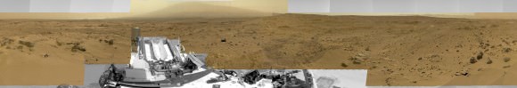
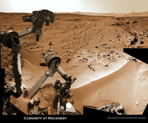
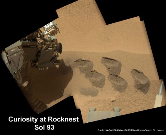
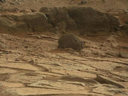
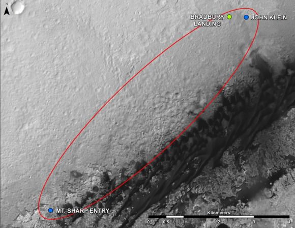
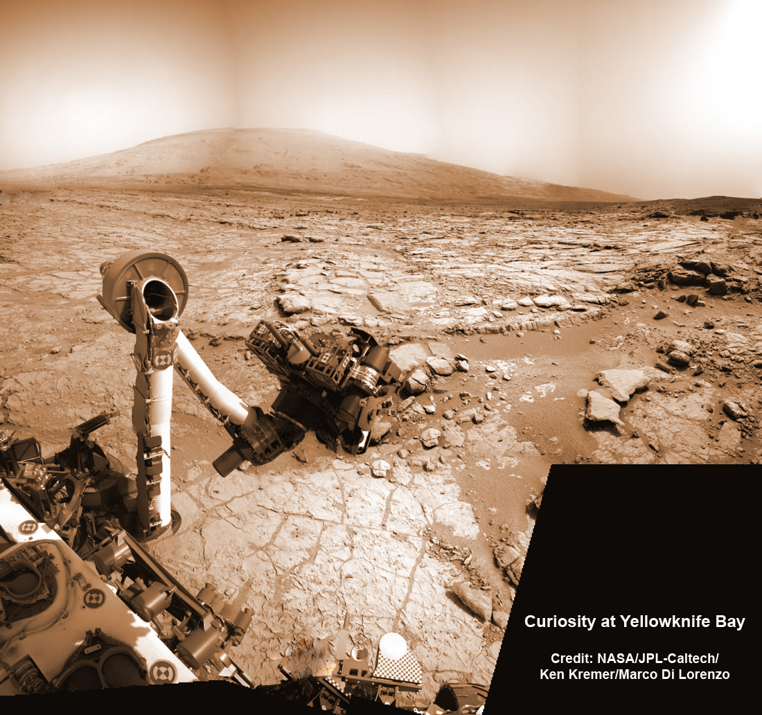
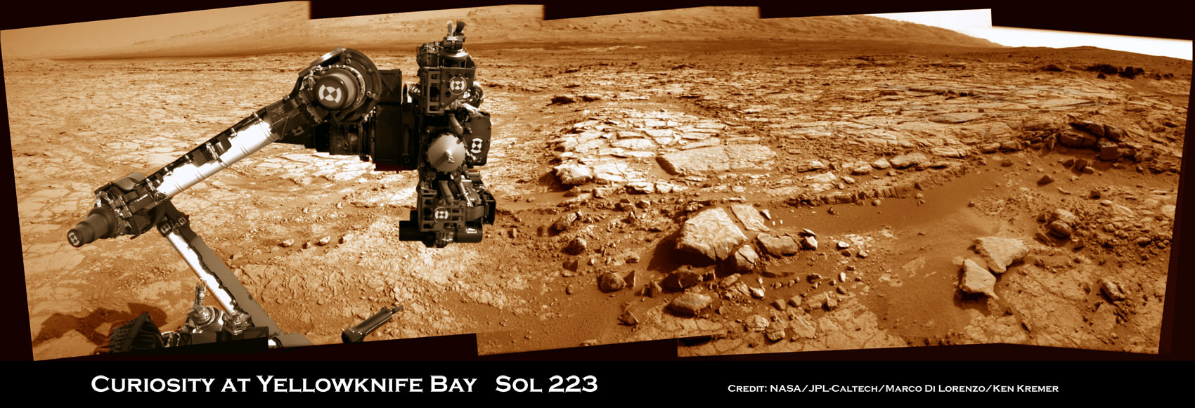
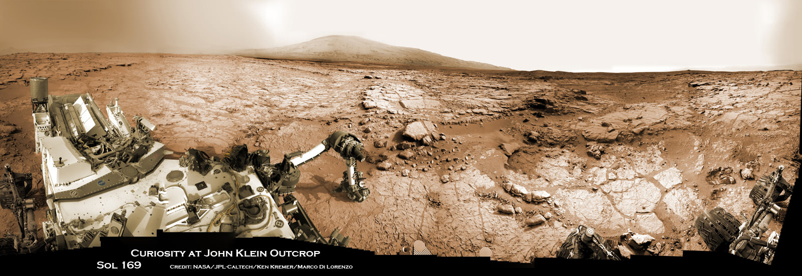
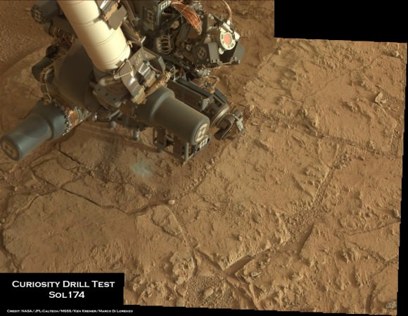
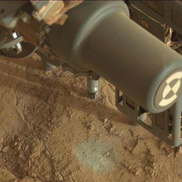
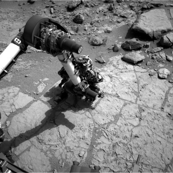
On July 4 (Sol 324), the six wheeled robot started driving away from the Glenelg and Yellowknife Bay areas where she has worked more than half a year investigating the alien terrain and drilling into Martian rocks for the first time in history.

“We have started the long traverse to the base of Mt. Sharp (Aeolis Mons), the long-term goal of the mission!” announced science team member Ken Herkenhoff of the USGS.

So far the NASA rover already driven more than 190 feet (58 meters) over two excursions on July 4 and 7, away from her last science campaign at the Shaler outcrop of cross-bedded, sedimentary outcrops. Another drive is planned today.

Billions of years of Mars geologic history are preserved in the sedimentary layers of Mount Sharp- including the ancient time period when the Red Planet was far wetter and warmer than today, and thus more hospitable to the origin of life.

Billion-Pixel View From Curiosity at Rocknest, Raw Color.  This full-circle view combined nearly 900 images taken by NASA's Curiosity Mars rover, generating a panorama with 1.3 billion pixels in the full-resolution version. The view is centered toward the south, with north at both ends. It shows Curiosity at the "Rocknest" site where the rover scooped up samples of windblown dust and sand. Curiosity used three cameras to take the component images on several different days between Oct. 5 and Nov. 16, 2012. Credit: NASA/JPL-Caltech/MSSS
Billion-Pixel View From Curiosity at Rocknest, Raw Color. This full-circle view combined nearly 900 images taken by NASA’s Curiosity Mars rover, generating a panorama with 1.3 billion pixels in the full-resolution version. The view is centered toward the south, with north at both ends. It shows Curiosity at the “Rocknest” site where the rover scooped up samples of windblown dust and sand. Curiosity used three cameras to take the component images on several different days between Oct. 5 and Nov. 16, 2012. Credit: NASA/JPL-Caltech/MSSS

The huge mountain rises about 3.4 miles (5.5 km) from the center of Gale Crater. Its taller than Mount Ranier in Washington State.

The overland journey could take nearly a year or even longer into 2014 to arrive at the base of Mount Sharp, depending on what the 1 ton behemoth sees along the way.

And the scientists are eager to make as many discoveries as possible.

“The mission is discovery driven,” says John Grotznger of the California Institute of Technology in Pasadena, Calif., who leads NASA’s Curiosity Mars Science Laboratory mission. “We will go to where the science takes us.”

This is a cropped, reduced version of panorama from NASA's Mars rover Curiosity with 1.3 billion pixels in the full-resolution version see full panorama below. It shows Curiosity at the "Rocknest" site where the rover scooped up samples of windblown dust and sand. Curiosity used three cameras to take the component images on several different days between Oct. 5 and Nov. 16, 2012. Viewers can explore this image with pan and zoom controls at http://mars.nasa.gov/bp1/. Credit: NASA/JPL-Caltech/MSSS
This is a cropped, reduced version of panorama from NASA’s Mars rover Curiosity with 1.3 billion pixels in the full-resolution version see full panorama above. It shows Curiosity at the “Rocknest” site where the rover scooped up samples of windblown dust and sand. Curiosity used three cameras to take the component images on several different days between Oct. 5 and Nov. 16, 2012. Viewers can explore this image with pan and zoom controls at http://mars.nasa.gov/bp1/. Credit: NASA/JPL-Caltech/MSSS

NASA chose Gale Crater as the landing site specifically to dispatch Curiosity to investigate the sedimentary layers of Mount Sharp because in surveys from Mars orbit it exhibited signatures of clay minerals that form in neutral water and that could possibly support the origin and evolution of simple Martian life forms, past or present.

“We have a real desire to get to Mount Sharp because there we see variations in the mineralogy as we go up from the base to higher levels and a change in the record of the environment,” explained Joy Crisp of JPL, Curiosity’s deputy project scientist.

“If we pass something amazing and compelling we might turn around and drive back,” Crisp added.

“The challenge for the science team will be to identify the most important targets along the way, and to study them without delaying drive progress too much,” notes Herkenoff.

Mount Sharp lies about 5 miles (8 kilometers) distant – as the Martian crow flies.

And Curiosity must also pass through a potentially treacherous dune field to get there.

“We are looking for the best path though,” said Curiosity Project Manager Jim Erickson of NASA’s Jet Propulsion Laboratory, Pasadena, Calif. at a recent media briefing.

Fisheye view of Mount Sharp from the hazcam camera on July 6, 2013 (Sol 326).  Credit: NASA/JPL-Caltech
Fisheye view of Mount Sharp from the hazcam camera on July 6, 2013 (Sol 326). Credit: NASA/JPL-Caltech

11 months ago on Aug. 6 , 2012, Curiosity made an unprecedented pinpoint touchdown inside Gale Crater using the never before used Sky crane descent thrusters.

Long before even arriving at destination Mount Sharp, Curiosity has already successfully accomplished the key science objective of the mission when she discovered that liquid water flowed at this spot on Mars, it possesses the key chemical ingredients required for life and was habitable in the past.

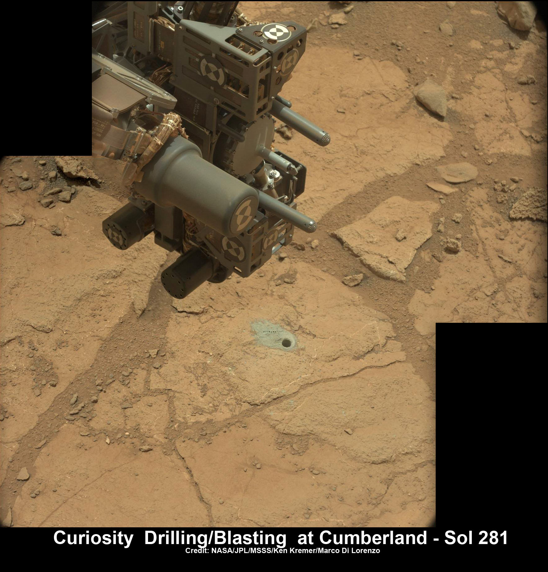
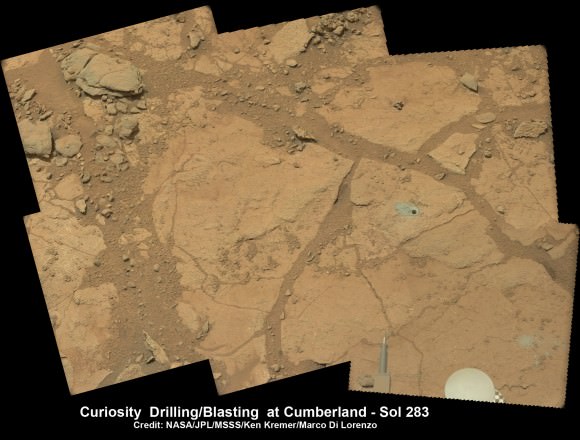
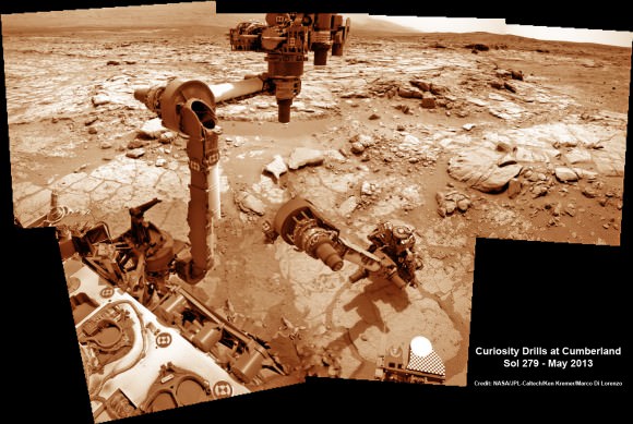
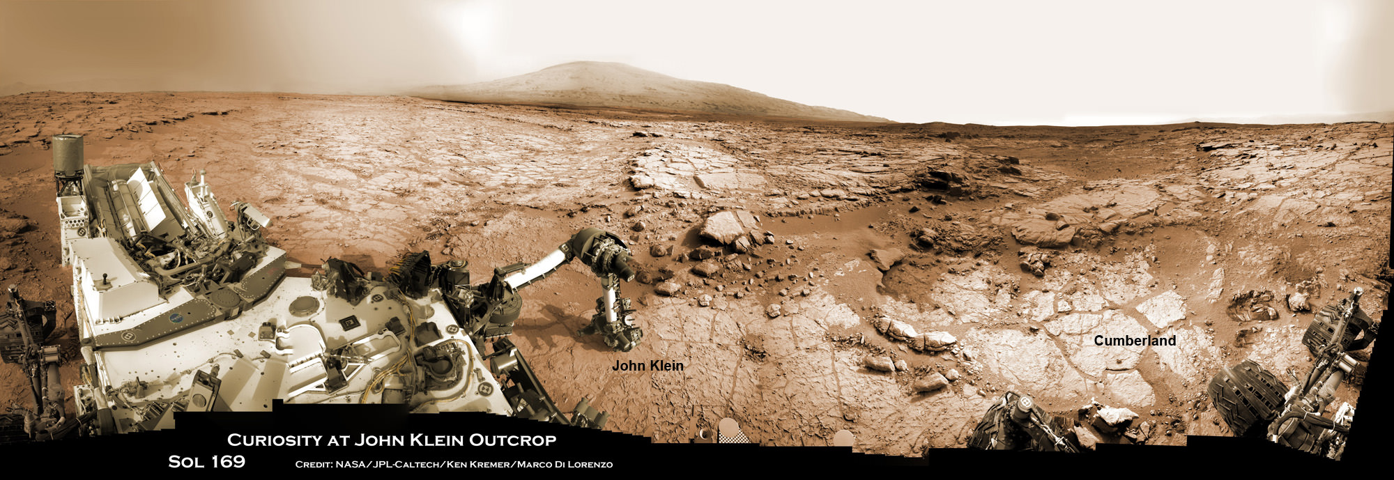
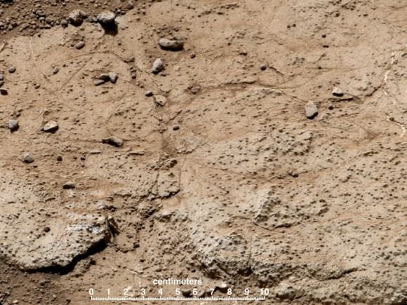
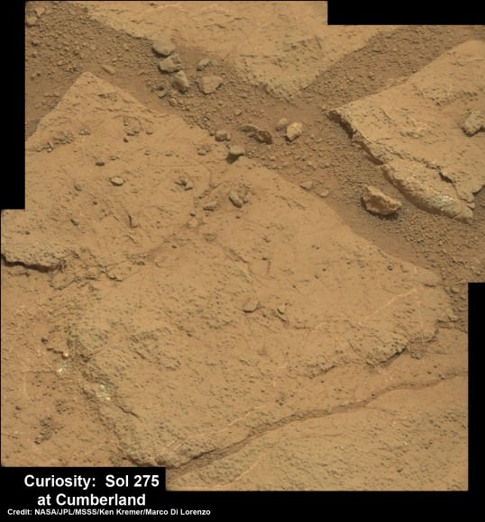
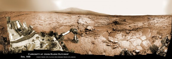
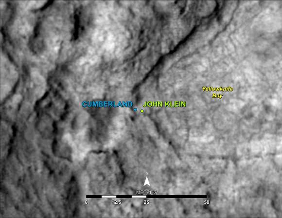
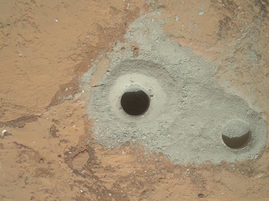
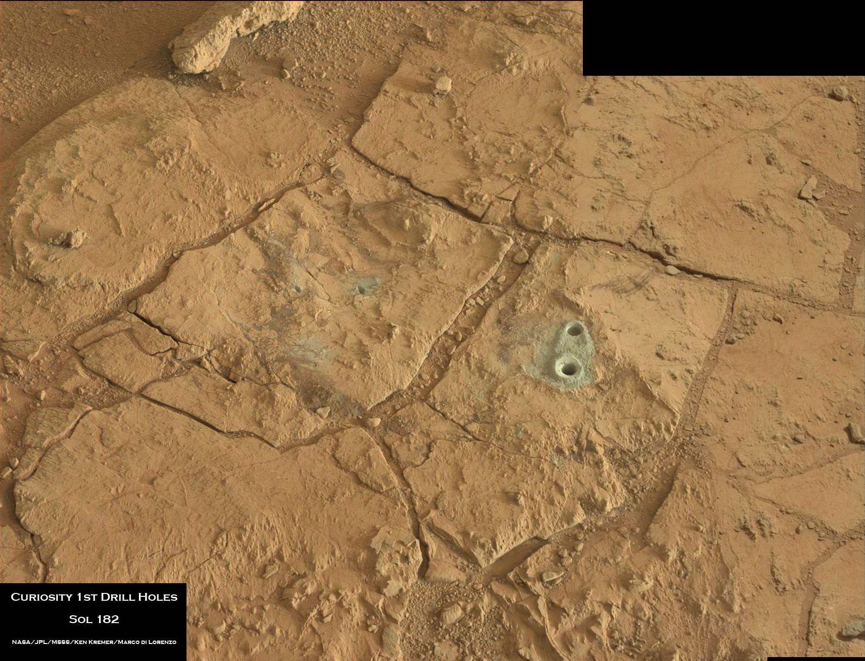
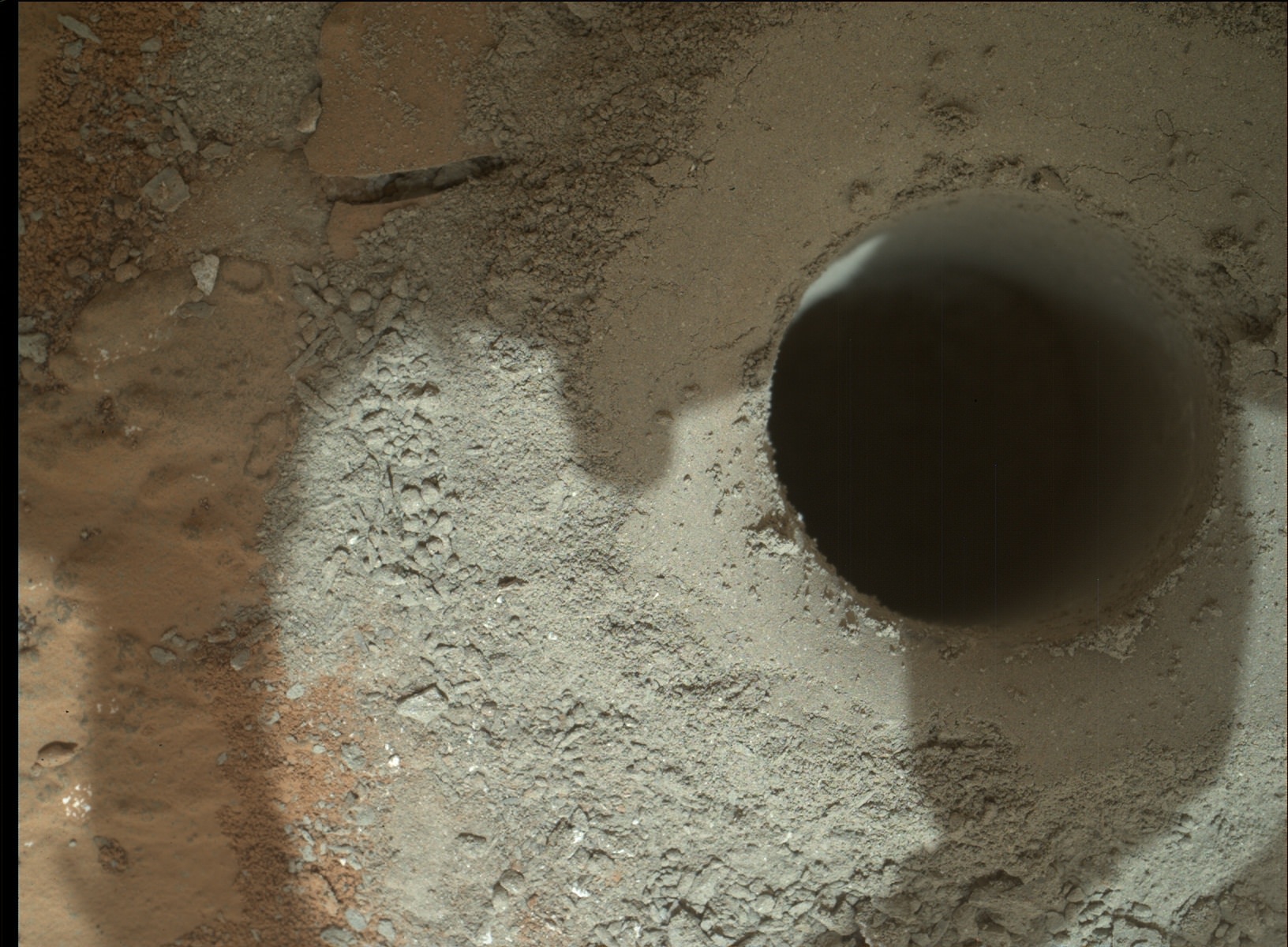
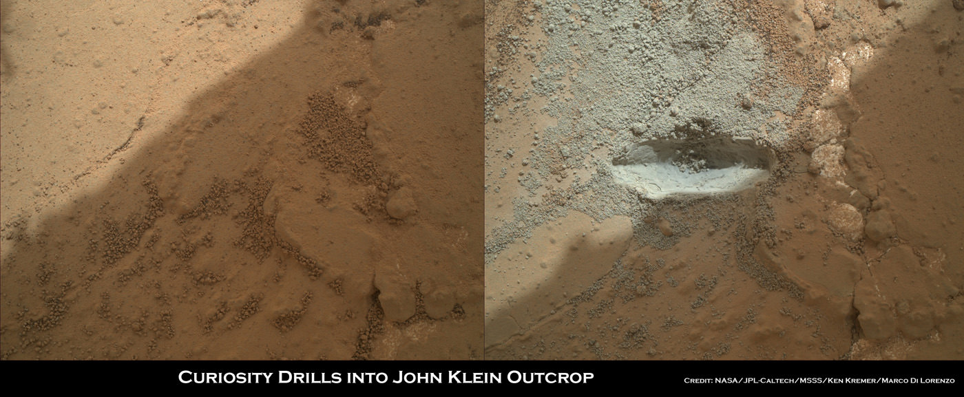
Drill samples from the ‘John Klein’ outcrop at Yellowknife Bay analyzed by Curiosity’s pair of onboard chemistry labs – SAM & Chemin – revealed that this location contains clay minerals required to support microbial life forms.

“We have found a habitable environment [at John Klein] which is so benign and supportive of life that probably if this water was around, and you had been on the planet, you would have been able to drink it,” said Grotzinger.

Ken Kremer

Spectacular Billion Pixel Panorama from NASA’s Curiosity Mars Rover

This is a cropped, reduced version of panorama from NASA's Mars rover Curiosity with 1.3 billion pixels in the full-resolution version see full panorama below. It shows Curiosity at the "Rocknest" site where the rover scooped up samples of windblown dust and sand. Curiosity used three cameras to take the component images on several different days between Oct. 5 and Nov. 16, 2012. Viewers can explore this image with pan and zoom controls at http://mars.nasa.gov/bp1/. Credit: NASA/JPL-Caltech/MSSS

This is a cropped, reduced version of panorama from NASA’s Mars rover Curiosity with 1.3 billion pixels in the full-resolution version. See full panorama below. It shows Curiosity at the “Rocknest” site where the rover scooped up samples of windblown dust and sand. Curiosity used three cameras to take the component images on several different days between Oct. 5 and Nov. 16, 2012. Viewers can explore this image with pan and zoom controls at http://mars.nasa.gov/bp1/. Credit: NASA/JPL-Caltech/MSSS
Updated with link to interactive Gigapan version
[/caption]

NASA’s newly produced and absolutely spectacular panorama from the Curiosity mega rover offers armchair explorers back on Earth a mammoth 1.3 billion pixels worth of Mars in all its colorful glory.

And everyone can move back and forth around the interactive panorama and zoom in – with special embedded tools- to your hearts delight in exquisite detail at the ‘Rocknest’ site where the rover spent her first extended science stay in late 2012.

This extra special Rocknest panorama is the first NASA- produced view comprising more than a billion pixels from the surface of the Red Planet.

It offers a full 360 degree panoramic view around the rover encompassing breathtaking vistas of Mount Sharp and the eerie rim of Gale Crater, some 20 miles distant.

Mount Sharp rises 3.4 miles (5.5 km) high and is the target destination. The team hopes Curiosity will arrive at the base of Mount Sharp perhaps late this year or early in 2014.

The ‘Rocknest’ scene was assembled from nearly 900 raw images snapped by three different cameras among the 17 total that Curiosity uses as she trundles across the crater floor in search of the ingredients of life.

Billion-Pixel View From Curiosity at Rocknest, Raw Color.  This full-circle, reduced view combined nearly 900 images taken by NASA's Curiosity Mars rover, generating a panorama with 1.3 billion pixels in the full-resolution version. The view is centered toward the south, with north at both ends. It shows Curiosity at the "Rocknest" site where the rover scooped up samples of windblown dust and sand. Curiosity used three cameras to take the component images on several different days between Oct. 5 and Nov. 16, 2012. Credit: NASA/JPL-Caltech/MSSS
Billion-Pixel View From Curiosity at Rocknest, Raw Color. This full-circle, reduced view combined nearly 900 images taken by NASA’s Curiosity Mars rover, generating a panorama with 1.3 billion pixels in the full-resolution version. The view is centered toward the south, with north at both ends. It shows Curiosity at the “Rocknest” site where the rover scooped up samples of windblown dust and sand. Curiosity used three cameras to take the component images on several different days between Oct. 5 and Nov. 16, 2012. Credit: NASA/JPL-Caltech/MSSS

The panorama was created by Bob Deen of the Multi-Mission Image Processing Laboratory at NASA’s Jet Propulsion Laboratory, Pasadena, Calif, where the mission is managed on a daily basis.

“It gives a sense of place and really shows off the cameras’ capabilities,” said Deen in a statement. “You can see the context and also zoom in to see very fine details.”

Check here for the full, billion pixel interactive cylindrical and panoramic viewers

Download the full image –here.

“Rocknest” was a windblown ripple of sand dunes that Curiosity drove to after departing from the touchdown site at ‘Bradbury Landing’ and thoroughly investigated in October and November 2012.

It was at ‘Rocknest’ where the six wheeled rover famously deployed her robotic arm to scoop into the Martian dirt for the very first time and then delivered those first grains to the duo of analytical chemistry labs inside her belly that lie at the heart of Curiosity’s science mission.

Deen assembled the color product using 850 raw images from the 100 mm telephoto camera of Curiosity’s Mast Camera instrument, supplemented with 21 more from the Mastcam’s wider-angle 34 mm camera.

In order to take in the rover itself, the view also included 25 black-and-white raw images from the Navigation Camera on the Mast.

All the images were taken between Oct. 5 and Nov. 16, 2012 while the rover was stationary at Rocknest.

Link to the interactive GigaPan version – here

And check this link to a new NASA JPL Curiosity gallery on the GigaPan website – here

Because the images were captured over many days and at different times of day, the lighting and atmospheric clarity varies – especially in distant views to the crater rim.

Since landing on August 6, 2012, Curiosity has already accomplished her primary goal of finding a habitable zone at Gale Crater with an environment that could once of supported Martian microbial life – at the current worksite at ‘Yellowknife Bay.’

Time lapse context view of Curiosity maneuvering her robotic arm to conduct close- up examination of windblown ‘Rocknest’ ripple site.  Curiosity inspects “bootlike” wheel scuff mark with the APXS (Alpha Particle X-Ray Spectrometer) and MAHLI (Mars Hand Lens Imager) instruments positioned on the rotatable turret at the arm’s terminus. Mosaic stitched from Navcam images on Sols 57 & 58 shows the arm in action just prior to 1st sample scooping here. Eroded rim of Gale Crater rim is visible on the horizon. Credit: NASA/JPL-Caltech/Ken Kremer (kenkremer.com)/Marco Di Lorenzo
Time lapse context view of Curiosity maneuvering her robotic arm to conduct close- up examination of windblown ‘Rocknest’ ripple site. Curiosity inspects “bootlike” wheel scuff mark with the APXS (Alpha Particle X-Ray Spectrometer) and MAHLI (Mars Hand Lens Imager) instruments positioned on the rotatable turret at the arm’s terminus. Mosaic stitched from Navcam images on Sols 57 & 58 shows the arm in action just prior to 1st sample scooping here. Eroded rim of Gale Crater rim is visible on the horizon. Credit: NASA/JPL-Caltech/Ken Kremer (kenkremer.com)/Marco Di Lorenzo

The 1 ton robot is equipped with 10 state-of-the-art science instruments with research capabilities that far surpass any prior landed mission and is in the middle of the 2-year primary mission to the Red Planet.

Meanwhile, Curiosity’s older sister rover Opportunity has also discovered clay minerals and a habitable zone on the opposite side of the Red Planet – details here.

And don’t forget to “Send Your Name to Mars” aboard NASA’s MAVEN orbiter- details here. Deadline: July 1, 2013

Ken Kremer

…………….
Learn more about Mars, Curiosity, Opportunity, MAVEN, LADEE and NASA missions at Ken’s upcoming lecture presentations

June 23: “Send your Name to Mars on MAVEN” and “CIBER Astro Sat, LADEE Lunar & Antares Rocket Launches from Virginia”; Rodeway Inn, Chincoteague, VA, 8 PM

Curiosity scooped 5 times into Martian soil at Rocknest windblown ripple and delivered samples to the SAM chemistry instrument for analysis. This color mosaic was stitched together from hi-res color images taken by the robots 34 mm Mastcam camera on Sols 93 and 74. Credit: NASA / JPL-Caltech /MSSS/Ken Kremer (kenkremer.com)/Marco Di Lorenzo

Curiosity Gets Set for Epic Drive after Laser Blasting Mars Watery Secrets

Curiosity’s hi tech ‘hand’ and percussion drill hovers above 2nd bore hole at Cumberland mudstone rock after penetrating laser blasting to unlock secrets of ancient flow of Martian water. Photo mosaic assembled from high resolution Mastcam images on May 21, 2013, Sol 281. Credit: NASA/JPL-Caltech/MSSS/Ken Kremer (kenkremer.com)/Marco Di Lorenzo

Ten months after her breathtaking touchdown on the Red Planet, NASA’s Curiosity rover is nearly set to embark on an epic drive like no other in space history to the slopes of mysterious Mount Sharp – looming supreme inside Gale Crater and the primary mission objective.

But not before the robot completes a few last critical science tasks to more fully illuminate the potential for the origin of Martian microbes in the habitable zone discovered at the work-site of her first penetrations into Mars water altered surface.

The rover science team has chosen a trio of final targets to investigate around the shallow basin of Yellowknife Bay, that resembles a dried out lakebed, where Curiosity has toiled for the past six months, drilled twice into the mudstone outcrops at ‘John Klein’ and ‘Cumberland’ and repeatedly fired her powerful science laser.

Curiosity will revisit a pair of intriguing outcrops named ‘Point Lake’ and ‘Shaler’ that the rover briefly investigated before arriving at ‘John Klein’, said Joy Crisp of JPL, Curiosity’s deputy project scientist, at a media briefing.

“Shaler might be a river deposit. Point Lake might be volcanic or sedimentary. A closer look at them could give us better understanding of how the rocks we sampled with the drill fit into the history of how the environment changed.”

Curiosity will employ nearly all her science instruments to study the outcrops – except the drill.

“It’s highly unlikely to drill at ‘Point Lake’ and ‘Shaler’ because we want to get driving,” Crisp told Universe Today.

“We might drill somewhere along the way to Mount Sharp depending on whether we find something compelling.”

'Point Lake' Outcrop in Gale Crater.  A priority target for a closer look byCuriosity before the rover departs the "Glenelg" area east of its landing site. The pitted outcrop called "Point Lake" is about 7 feet (2 meters) wide and 20 inches (50 centimeters) high.  A closer inspection may yield information about whether it is a volcanic or sedimentary deposit. Credit: NASA/JPL-Caltech/MSSS
‘Point Lake’ Outcrop in Gale Crater. A priority target for a closer look byCuriosity before the rover departs the “Glenelg” area east of its landing site. The pitted outcrop called “Point Lake” is about 7 feet (2 meters) wide and 20 inches (50 centimeters) high. A closer inspection may yield information about whether it is a volcanic or sedimentary deposit. Credit: NASA/JPL-Caltech/MSSS

Researchers will also use the DAN (Dynamic Albedo of Neutrons) instrument to look for traces of mineral bound water – in the form of hydrogen – at the boundary between bedrock areas of mudstone and sandstone.

Thereafter, Curiosity’s handlers will command the 1 ton behemoth to begin the drive to the lower reaches of Mount Sharp which lies about 6 miles (10 kilometers) distant – as the Martian crow flies.

Mount Sharp rises about 3.4 miles (5.5 km) from the center of Gale Crater. It’s taller than Mount Ranier in Washington State.

Billions of years of Mars geologic history are preserved in the sedimentary layers of Mount Sharp – along with potential signatures of the chemical ingredients of life.

Curiosity Route Map From 'Glenelg' to Mount Sharp. This map shows where NASA's Mars rover Curiosity landed in August 2012 at "Bradbury Landing"; the area where the rover worked from November 2012 through May 2013 at and near the "John Klein" target rock in the "Glenelg" area; and the mission's next major destination, the entry point to the base of Mount Sharp.  Credit: NASA/JPL-Caltech/Univ. of Arizona
Curiosity Route Map From ‘Glenelg’ to Mount Sharp.
This map shows where NASA’s Mars rover Curiosity landed in August 2012 at “Bradbury Landing”; the area where the rover worked from November 2012 through May 2013 at and near the “John Klein” target rock in the “Glenelg” area; and the mission’s next major destination, the entry point to the base of Mount Sharp. Credit: NASA/JPL-Caltech/Univ. of Arizona

“The drive will start in a few weeks,” said Curiosity Project Manager Jim Erickson of NASA’s Jet Propulsion Laboratory, Pasadena, Calif. at the briefing.

But the team will be on the lookout for targets of opportunity along the way.

“We are on a mission of exploration. If we come across scientifically interesting areas, we are going to stop and examine them before continuing the journey,” Erikson added.

“If we pass something amazing and compelling we might turn around and drive back,” Crisp added.

It could take nearly a year to arrive at Mount Sharp. And Curiosity must pass through a potentially treacherous dune field to get there – see NASA JPL route map above.

“We are looking for the best path though,” said Erickson.

NASA chose Gale as the landing site specifically to dispatch Curiosity to investigate the sedimentary layers of Mount Sharp because it exhibited signatures of clay minerals that form in neutral water and that could possibly support the origin and evolution of simple Martian life forms, past or present.

“We have a real desire to get to Mount Sharp because there we see variations in the mineralogy as we go up from the base to higher levels and a change in the record of the environment,” said Crisp.

Analysis of the initial gray colored, powdery ‘John Klein’ sample by Curiosity’s pair of onboard chemistry labs – SAM & Chemin – revealed that this location on Mars was habitable in the past and possesses the key chemical ingredients – such as clay minerals – required to support microbial life forms- thereby successfully accomplishing the key science objective of the mission and making a historic discovery long before even arriving at destination Mount Sharp.

Besides the science measurements, researchers also learned lot about how to operate the complex drilling and sample delivery mechanisms much more efficiently for the second drilled rock sample.

The sieved and pulverized Cumberland sample was delivered in about a quarter of the time compared to the John Klein sample – accomplished at a deliberately measured and cautious pace.

Context view of Curiosity’s 2nd drill site at Cumberland rock on the floor of Yellowknife Bay basin of ancient water altered rocks where the rover found environmental conditions favorable for microbial life. Mastcam images on May 23, 2013, Sol 283.  Credit: NASA/JPL-Caltech/MSSS/Ken Kremer (kenkremer.com)/Marco Di Lorenzo
Context view of Curiosity’s 2nd drill site at Cumberland rock on the floor of Yellowknife Bay basin showing ancient water altered rocks where the rover found environmental conditions favorable for microbial life. Mastcam images on May 23, 2013, Sol 283. Credit: NASA/JPL-Caltech/MSSS/Ken Kremer (kenkremer.com)/Marco Di Lorenzo

Analysis of the “Cumberland” powder is currently in progress. The goal is to determine how it compares chemically and to confirm the results found at ‘John Klein.’

“No results from Cumberland are available yet,” said Crisp.

The robot used the powerful million watt ChemCam laser to blast into the Cumberland drill hole and gray tailings scattered on the surface to glean as much insight and measurements of the chemical composition and transformation by water as possible before departing.

Curiosity has just arrived at “Point Lake’. Stay tuned for my next Curiosity story.

Meanwhile, Curiosity’s older sister rover Opportunity has likewise discovered clay minerals and a habitable zone on the opposite side of the Red Planetdetails here.

And don’t forget to “Send Your Name to Mars” aboard NASA’s MAVEN orbiter- details here. Deadline: July 1, 2013

Ken Kremer

…………….

Learn more about Mars, Curiosity, Opportunity, MAVEN, LADEE and NASA missions at Ken’s upcoming lecture presentations

June 23: “Send your Name to Mars on MAVEN” and “CIBER Astro Sat, LADEE Lunar & Antares Rocket Launches from Virginia”; Rodeway Inn, Chincoteague, VA, 8 PM

This time lapse mosaic shows Curiosity moving her robotic arm to drill into her 2nd rockt target named “Cumberland” to collect powdery material on May 19, 2013 (Sol 279) for analysis by her onboard chemistry labs; SAM & Chemin. The photomosaic was stitched from raw images captured by the navcam cameras on May 14 & May 19 (Sols 274 & 279).  Credit: NASA/JPL-Caltech/Ken Kremer/Marco Di Lorenzo
This time lapse mosaic shows Curiosity moving her robotic arm to drill into her 2nd rockt target named “Cumberland” to collect powdery material on May 19, 2013 (Sol 279) for analysis by her onboard chemistry labs; SAM & Chemin. The photomosaic was stitched from raw images captured by the navcam cameras on May 14 & May 19 (Sols 274 & 279). Credit: NASA/JPL-Caltech/Ken Kremer/Marco Di Lorenzo

Drill, Baby, Drill! – How Does Curiosity ‘Do It’

Panoramic view of Yellowknife Bay basin back dropped by Mount Sharp shows the location of the first two drill sites - John Klein & Cumberland - targeted by NASA’s Curiosity Mars rover. Curiosity accomplished historic 1st drilling into Martian rock at John Klein outcrop on Feb 8, 2013 (Sol 182) near where the robotic arm is touching the surface. This week the rover scooted about 9 feet to the right to Cumberland (right of center) for 2nd drill campaign in late-May 2013. Credit: NASA/JPL-Caltech/Ken Kremer/Marco Di Lorenzo

Video Caption: This JPL video shows the complicated choreography to get drill samples to Curiosity’s instruments as she prepares for 2nd drilling at “Cumberland.” See where “Cumberland” is located in our panoramic photo mosaic below.

It’s time at last for “Drill, Baby, Drill!” – Martian Style.

Ever wonder how Curiosity “Does It”

Well, check out this enlightening and cool new NASA video for an exquisitely detailed demonstration of just how Curiosity shakes, rattles and rolls on the Red Planet and swallows that mysterious Martian powder.

“Shake, shake, shake… shake that sample. See how I move drilled rock to analytical instruments,” tweeted Curiosity to millions of fans.

Get set to witness Martian gyrations like you’ve never seen before.

After a pair of short but swift moves this past week, NASA’s Curiosity rover is finally in position to bore into the Red Planet’s alien surface for the second time – at a target called “Cumberland.”

See where “Cumberland” is located in our panoramic photo mosaic below.

“Two short drives & 3.8 meters later, I’m zeroing in on my second Mars drilling target,” tweeted Curiosity.

Panoramic view of Yellowknife Bay basin back dropped by Mount Sharp shows the location of the first two drill sites – John Klein & Cumberland – targeted by NASA’s Curiosity Mars rover. Curiosity accomplished historic 1st drilling into Martian rock at John Klein outcrop on Feb 8, 2013 (Sol 182) near where the robotic arm is touching the surface. This week the rover scooted about 9 feet to the right to Cumberland (right of center) for 2nd drill campaign in late-May 2013.
Credit: NASA/JPL-Caltech/Ken Kremer/Marco Di Lorenzo [/caption]

These were Curiosity’s first drives since arriving at the “John Klein” outcrop in mid- January 2013 where she carried out the historic first ever interplanetary drilling by a robot on another world.

For the past few days the robot has snapped a series of close up images of “Cumberland” with the high resolution MAHLI camera on the “hand” of the dextrous robotic arm.

And now that Curiosity has switched to the B-side computer, the rover has switched over to an back up set of never before used cameras on the mast head, which appear to be functioning perfectly.

“Curiosity is now using the new pair of navigation cameras associated with the B-side computer,” said Curiosity science team member Kimberly Lichtenberg to Universe Today.

The rover also evaluated the potential drill site with the ChemCAM and APXS instruments to confirm whether ‘Cumberland’ is indeed a worthy target for the time consuming process to collect the drill tailings for delivery to the duo of miniaturized chemistry labs named SAM and Chemin inside her belly

As outlined in the video, the robot engages in an incredibly complex procedure to collect the drill bit tailings and then move and pulverize them through the chambers of the CHIMRA sample system on the tool turret for processing, filtering and delivery for in situ analysis that could take weeks to complete.

This patch of bedrock, called "Cumberland," has been selected as the second target for drilling by NASA's Mars rover Curiosity. The rover has the capability to collect powdered material from inside the target rock and analyze that powder with laboratory instruments. The favored location for drilling into Cumberland is in the lower right portion of the image. Credit: NASA/JPL-Caltech/MSSS
This patch of bedrock, called “Cumberland,” has been selected as the second target for drilling by NASA’s Mars rover Curiosity. The rover has the capability to collect powdered material from inside the target rock and analyze that powder with laboratory instruments. The favored location for drilling into Cumberland is in the lower right portion of the image. Credit: NASA/JPL-Caltech/MSSS

The state-of-the-art SAM and Chemin chemistry labs test aspirin sized quantities of the carefully sieved powder for the presence of organic molecules – the building blocks of life – and determine the inorganic chemical composition.

The science team wants to know how ‘Cumberland’ stacks up compared to ‘John Klein’, inside the shallow depression named ‘Yellowknife Bay’ where Curiosity has been exploring since late 2012.

“We’ll drill another hole to confirm what we found in the John Klein hole,” said John Grotzinger to Universe Today. Grotzinger, of the California Institute of Technology in Pasadena, Calif., leads NASA’s Curiosity Mars Science Laboratory mission.

‘Cumberland’ and ‘John Klein’ are patches of flat-lying bedrock shot through with pale colored hydrated mineral veins composed of calcium sulfate hydrated and a bumpy surface texture at her current location inside the ‘Yellowknife Bay’ basin that resembles a dried out lake bed.

“The bumpiness is due to erosion-resistant nodules within the rock, which have been identified as concretions resulting from the action of mineral-laden water,” according to NASA.

At Yellowknife Bay, Curiosity found evidence for an ancient habitable environment that could possibly have supported simple Martian microbial life forms eons ago when the Red Planet was warmer and wetter.

Analysis of the gray colored rocky Martian powder at ‘John Klein’ revealed that the fine-grained, sedimentary mudstone rock possesses significant amounts of phyllosilicate clay minerals; indicating the flow of nearly neutral liquid water and a habitat friendly to the possible origin of microbes.

Curiosity is expected to drill and swallow the ‘Cumberland’ powder at any moment if all goes well, a team member told Universe Today.

High resolution close-up of Cumberland outcrop on Sol 275 (May 15, 2013).   Photo mosaic of Mastcam 100  raw images.  Credit: NASA/JPL-Caltech/MSSS/Ken Kremer/Marco Di Lorenzo
High resolution close-up of Cumberland outcrop on Sol 275 (May 15, 2013) – where Curiosity will bore her 2nd drill hole. Photo mosaic of Mastcam 100 raw images. Credit: NASA/JPL-Caltech/MSSS/Ken Kremer/Marco Di Lorenzo

Meanwhile as Curiosity was moving to Cumberland, her older sister Opportunity was blazing a trail at Endeavour Crater on the opposite side of Mars and breaking the distance driving record for an American space rover. Read all about it in my new story – here.

And don’t forget to “Send Your Name to Mars” aboard NASA’s MAVEN orbiter- details here. Deadline: July 1, 2013

Ken Kremer

…………….
Learn more about Mars, Curiosity, Opportunity, MAVEN, LADEE and NASA missions at Ken’s upcoming lecture presentations:

June 11: “Send your Name to Mars” and “LADEE Lunar & Antares Rocket Launches from Virginia”; NJ State Museum Planetarium and Amateur Astronomers Association of Princeton (AAAP), Trenton, NJ, 8 PM.

June 12: “Send your Name to Mars” and “LADEE Lunar & Antares Rocket Launches from Virginia”; Franklin Institute and Rittenhouse Astronomical Society, Philadelphia, PA, 8 PM.

Curiosity Reaches Out with Martian Handshake and Contemplates New Drilling at Habitable Site

NASA’s Curiosity rover reaches out in ‘handshake’ like gesture to welcome the end of solar conjunction and resumption of contact with Earth. This mosaic of images was snapped by Curiosity on Sol 262 (May 2) and shows her flexing the robotic arm with Mount Sharp in the background. Two drill holes are visible on the surface bedrock below the robotic arm’s turret. Credit: NASA/JPL-Caltech/Ken Kremer-(kenkremer.com)/Marco Di Lorenzo

NASA’s Curiosity rover reaches out in ‘handshake’ like gesture to welcome the end of solar conjunction and resumption of contact with Earth. This mosaic of images was snapped by Curiosity on Sol 262 (May 2, 2013) and shows her flexing the robotic arm with dramatic scenery of Mount Sharp in the background. Two drill holes are visible on the surface bedrock below the robotic arm’s turret where she discovered a habitable site.
Credit: NASA/JPL-Caltech/Ken Kremer-(kenkremer.com)/Marco Di Lorenzo[/caption]

NASA’s Curiosity rover has reached out in a Martian ‘handshake’ like gesture welcoming the end of solar conjunction that marks the resumption of contact with her handlers back on Earth – evidenced in a new photo mosaic of images captured as the robot and her human handlers contemplate a short traverse to a 2nd drilling target in the next few days.

“We’ll move a small bit and then drill another hole,” said John Grotzinger to Universe Today. Grotzinger, of the California Institute of Technology in Pasadena, Calif., leads NASA’s Curiosity Mars Science Laboratory mission.

The rover science team and Grotzinger have selected that 2nd drill location and are itching to send the rover on her way to the bumpy spot called “Cumberland.”

Cumberland lies about nine feet (2.75 meters) west of the “John Klein’ outcrop where Curiosity conducted humanity’s first ever interplanetary drilling on the alien Martian surface in February 2013.

“We’ll confirm what we found in the John Klein hole,” Grotzinger told me.

Curiosity discovered a habitable zone at the John Klein drill site.

After pulverizing and carefully sifting the John Klein drill tailings, a powered, aspirin sized portion of the gray rock was fed into a trio of inlet ports atop the rovers deck and analyzed by Curiosity’s duo of miniaturized chemistry labs named SAM and Chemin inside her belly to check for the presence of organic molecules and determine the inorganic chemical composition.

‘Cumberland’ and ‘John Klein’ are patches of flat-lying bedrock shot through with pale colored calcium sulfate hydrated mineral veins and a bumpy surface texture at her current location inside the ‘Yellowknife Bay’ basin.

This patch of bedrock, called "Cumberland," has been selected as the second target for drilling by NASA's Mars rover Curiosity. The rover has the capability to collect powdered material from inside the target rock and analyze that powder with laboratory instruments. The favored location for drilling into Cumberland is in the lower right portion of the image. Credit: NASA/JPL-Caltech/MSSS
This patch of bedrock, called “Cumberland,” has been selected as the second target for drilling by NASA’s Mars rover Curiosity. The rover has the capability to collect powdered material from inside the target rock and analyze that powder with laboratory instruments. The favored location for drilling into Cumberland is in the lower right portion of the image. Credit: NASA/JPL-Caltech/MSSS

“The bumpiness is due to erosion-resistant nodules within the rock, which have been identified as concretions resulting from the action of mineral-laden water,” NASA said in a statement.

Curiosity snapped high resolution color images of Cumberland on Sol 192 (Feb. 19, 2013) as part of the ongoing data collection campaign to put Yellowknife Bay into scientific context and search for future drill targets.

The John Klein bore hole (drilled on Feb 8, 2013, Sol 182) is visible in our new photo mosaic above created by myself and my imaging partner Marco Di Lorenzo. It was stitched from a ‘Martian baker’s dozen’ of raw images captured on May 2 (Sol 262). and shows the hand-like tool turret positioned above the first pair of drill holes.

Our new Sol 262 mosaic illustrates that Curiosity is again fully functional and flexing the miracle arm following a relaxing month long period of ‘Spring Break’ when there was no two- way communication with Earth during April’s solar conjunction.

The Sol 262 photo mosaic was originally featured at NBC News by Cosmic Log science editor Alan Boyle who likened it to a future Martian handshake in this cleverly titled story; “Curiosity’s ‘hand’ outstretched on Mars: Will humans ever shake it?”

See below our Sol 169 panoramic context view of Curiosity inside Yellowknife Bay collecting spectroscopic science measurements at the John Klein outcrop.

Curiosity accomplished historic 1st drilling into Martian rock at John Klein outcrop on Feb 8, 2013 (Sol 182), shown in this context mosaic view of the Yellowknife Bay basin taken on Jan. 26 (Sol 169) - back dropped with Mount Sharp - where the robot is currently working. Curiosity will bore a 2nd drill hole soon following the resumption of contact with the end of the solar conjunction period. Credit: NASA/JPL-Caltech/Ken Kremer/Marco Di Lorenzo
Curiosity accomplished historic 1st drilling into Martian rock at John Klein outcrop on Feb 8, 2013 (Sol 182), shown in this context mosaic view of the Yellowknife Bay basin taken on Jan. 26 (Sol 169) – back dropped with Mount Sharp – where the robot is currently working. Curiosity will bore a 2nd drill hole soon following the resumption of contact with the end of the solar conjunction period. Credit: NASA/JPL-Caltech/Ken Kremer -(kenkremer.com)/Marco Di Lorenzo

Curiosity found that the fine-grained, sedimentary mudstone rock at the John Klein worksite inside the shallow depression known as Yellowknife Bay possesses significant amounts of phyllosilicate clay minerals; indicating the flow of nearly neutral liquid water and a habitat friendly to the possible origin of simple Martian microbial life forms eons ago.

Grotzinger also explained to Universe Today that Curiosity will soon to more capable than ever before.

“We’ll spend the next few sols transitioning over to new flight software that gives the rover additional capabilities’” said Grotzinger.

“Then we’ll spend some time testing out the science instruments on the B-side rover compute element – that we booted to before conjunction.”

Curiosity will spend a month or more at the Cumberland site to collect and completely analyze the drill tailings.

Then she’ll resume her epic trek to mysterious Mount Sharp, the 3.5 mile (5 km) high mountain that dominates her landing site and is her ultimate driving inside Gale Crater according to Grotzinger.

“After that [Cumberland] we’re likely to begin the trek to Mt. Sharp, though we’ll stop quickly to look at a few outcrops that we passed by on the way into Yellowknife Bay,” Grotzinger explained to Universe Today.

The Shaler outcrop passed by on the path into Yellowknife Bay is high on the list of stops during the year long journey to Mount Sharp, says Grotzinger. Read more details about Shaler in a new BBC story by Jonathan Amos – here – featuring our Shaler outcrop mosaic.

And don’t forget to “Send Your Name to Mars” aboard NASA’s MAVEN orbiter- details here. Deadline: July 1, 2013

Ken Kremer

…………….
Learn more about Mars, Curiosity and NASA missions at Ken’s upcoming lecture presentation:

June 12: “Send your Name to Mars” and “Antares Rocket Launch from Virginia”; Franklin Institute and Rittenhouse Astronomical Society, Philadelphia, PA, 8 PM.

This map shows the location of "Cumberland," the second rock-drilling target for NASA's Mars rover Curiosity, in relation to the rover's first drilling target, "John Klein," within the southwestern lobe of a shallow depression called "Yellowknife Bay." Cumberland, like John Klein, is a patch of flat-lying bedrock with pale veins and bumpy surface texture. The bumpiness is due to erosion-resistant nodules within the rock, which have been identified as concretions resulting from the action of mineral-laden water. Image credit: NASA/JPL-Caltech/Univ. of Arizona
This map shows the location of “Cumberland,” the second rock-drilling target for NASA’s Mars rover Curiosity, in relation to the rover’s first drilling target, “John Klein,” within the southwestern lobe of a shallow depression called “Yellowknife Bay.” Cumberland, like John Klein, is a patch of flat-lying bedrock with pale veins and bumpy surface texture. The bumpiness is due to erosion-resistant nodules within the rock, which have been identified as concretions resulting from the action of mineral-laden water. Image credit: NASA/JPL-Caltech/Univ. of Arizona

Curiosity is Back! Snapping Fresh Martian Vistas

Curiosity's raised robotic arm and drill are staring at you in this new panoramic vista of Yellowknife Bay basin snapped on March 23, Sol 223 by the rover's navigation camera system. The raw images were stitched by Marco Di Lorenzo and Ken Kremer and colorized. Credit: NASA/JPL-Caltech/Marco Di Lorenzo/KenKremer (kenkremer.com)

Curiosity is back! After a multi-week hiatus forced by a computer memory glitch, NASA’s mega rover is back to full operation.

And the proof is crystal clear in the beautiful new panoramic view (above) snapped by Curiosity this weekend from Yellowknife Bay, showing the robot’s arm and drill elevated and aiming straight at you – raring to go and ready to feast on something deliciously Martian.

“That drill is hungry, looking for something tasty to eat, and ‘you’ (loaded with water and organics) are it,” I thought with a chuckle as Curiosity seeks additional habitats and ingredients friendly to life.

So my imaging partner Marco Di Lorenzo and I celebrated the great news by quickly creating the new panoramic mosaic assembled from images taken on Saturday, March 23, or Sol 223, by the robot’s navigation cameras. Our new Curiosity mosaic was first featured on Saturday at NBC News Cosmic Log by Alan Boyle – while I was hunting for Comet Pan-STARRS.

So the fact that Curiosity is again snapping images and transmitting fresh alien vistas and new science data is a relief to eagerly waiting scientists and engineers here on Earth.

Drilling goes to the heart of the mission. It was absolutely essential to the key finding of Curiosity’s Martian foray thus far – that Mars possesses an environment where alien microbes could once have thrived in the distant past when the Red Planet was warmer and wetter.

Curiosity accomplished Historic 1st drilling into Martian rock at John Klein outcrop on Feb 8, 2013 (Sol 182), shown in this context mosaic view of the Yellowknife Bay basin taken on Jan. 26 (Sol 169) where the robot is currently working. The robotic arm is pressing down on the surface at John Klein outcrop of veined hydrated minerals – dramatically back dropped with her ultimate destination; Mount Sharp. Credit: NASA/JPL-Caltech/Ken Kremer/Marco Di Lorenzo

Curiosity has found widespread evidence for repeated episodes of flowing liquid water on the floor of her Gale Crater landing site – an essential prerequisite to life as we know it.

After coring and analyzing the first powder ever drilled from the interior of a Martian rock in February 2013, NASA’s Curiosity robot discovered some of the key chemical ingredients necessary to support life on early Mars billions of years ago.

Curiosity found that the fine-grained, sedimentary mudstone rock at the rovers current worksite inside the Yellowknife Bay basin possesses significant amounts of phyllosilicate clay minerals; indicating the flow of nearly neutral liquid water and a habitat friendly to the possible origin of simple Martian life forms eons ago.

Curiosity's First Sample Drilling hole is shown at the center of this image in a rock called "John Klein" on Feb. 8, 2013, or Sol 182 operations. The image was obtained by Curiosity’s Mars Hand Lens Imager (MAHLI). The sample-collection hole is 0.63 inch (1.6 centimeters) in diameter and 2.5 inches (6.4 centimeters) deep. The “mini drill” test hole near it is the same diameter, with a depth of 0.8 inch (2 centimeters). Credit: NASA/JPL-Caltech/MSSS
Curiosity’s First Sample Drilling hole is shown at the center of this image in a rock called “John Klein” on Feb. 8, 2013, or Sol 182 operations. The image was obtained by Curiosity’s Mars Hand Lens Imager (MAHLI). The sample-collection hole is 0.63 inch (1.6 centimeters) in diameter and 2.5 inches (6.4 centimeters) deep. The “mini drill” test hole near it is the same diameter, with a depth of 0.8 inch (2 centimeters). Credit: NASA/JPL-Caltech/MSSS

The rovers 7 foot (2.1 meter) long robotic arm fed aspirin sized samples of the gray, pulverized powder into the miniaturized CheMin and SAM analytical instruments on Feb. 22 and 23, or Sols 195 and 196. The samples were analyzed on Sol 200 and then the rover experienced her first significant problems since landing on Aug. 5, 2012.

The Chemistry and Mineralogy (CheMin) instrument and Sample Analysis at Mars (SAM) instruments test the Martian soil and rock samples to determine their chemical composition and search for traces of organic molecules – the building blocks of life

No organics have been found thus far.

The rover’s science mission has been on hold for nearly a month since “a memory glitch on the A-side computer on Feb. 27, which prompted controllers to command a swap from the A-side computer to the B-side computer,” according to a NASA statement.

“That operator-commanded swap put Curiosity into safe mode for two days. The rover team restored the availability of the A-side as a backup and prepared the B-side to resume full operations.”

The memory issue may have been caused by a cosmic ray strike. The rover suffered another minor setback last week, briefly reentering ‘safe mode’. And in between, a solar storm forced the team to shut Curiosity down for a few more days.

All appears well now.

The next step is to reanalyze those 1st gray rock tailings to continue the hunt for traces of organic molecules.

But the next solar conjunction will interrupt communications starting around April 4 for several weeks. More on that shortly.

After conjunction, Curiosity will resume her drilling campaign

Ken Kremer

…………….

Learn more about Curiosity’s groundbreaking discoveries and NASA missions at Ken’s upcoming lecture presentations:

April 20/21 : “Curiosity and the Search for Life on Mars – (in 3-D)”. Plus Orion, SpaceX, Antares, the Space Shuttle and more! NEAF Astronomy Forum, Suffern, NY

April 28: “Curiosity and the Search for Life on Mars – (in 3-D)”. Washington Crossing State Park, Titusville, NJ, 130 PM

Rover self portrait MAHLI mosaic taken this week has Curiosity sitting on the flat rocks of the “John Klein” drilling target area within the Yellowknife Bay depression. Note gradual rise behind rover. Credit: NASA/JPL-Caltech/MSSS/Marco Di Lorenzo/www.KenKremer.com.
Rover self portrait MAHLI mosaic taken this week has Curiosity sitting on the flat rocks of the “John Klein” drilling target area within the Yellowknife Bay depression. Note gradual rise behind rover. Credit: NASA/JPL-Caltech/MSSS/Marco Di Lorenzo/Ken Kremer (kenkremer.com)

What Mount Sharp Would Look Like on Earth

Gale crater's central peak as it might look under Earthly lighting (NASA/JPL-Caltech/MSSS)

Ahh — there’s nothing like a beautiful sunny day in Gale crater! The rusty sand crunching beneath your wheels, a gentle breeze blowing at a balmy 6º C (43º F), Mount Sharp rising in the distance into a clear blue sky… wait, did I just say blue sky?

I sure did. But no worries — Mars hasn’t sprouted a nitrogen-and-oxygen atmosphere overnight. The image above is a crop from a panoramic mosaic made of images from NASA’s Curiosity rover, showing Gale crater’s central peak Mount Sharp (or Aeolis Mons, if you prefer the official moniker.) Don’t let the blue sky fool you though — the lighting has been adjusted to look like a sunlit scene on Earth, if only to let geologists more easily refer to their own experience when studying the Martian landscape.

Click the image to see the full panorama, and a view of the same scene under more “natural” Martian lighting can be found below:

Aeolis Mons panorama seen in natural lighting (NASA/JPL-Caltech/MSSS)

According to JPL, in both versions the sky has been filled out by extrapolating color and brightness information from the portions of the sky that were captured in images of the terrain.

The elevation of Mt. Sharp compared to three mountains on Earth (NASA/JPL-Caltech/MSSS)

The component images were taken by the 100-millimeter-focal-length telephoto lens camera mounted on the right side of Curiosity’s remote sensing mast, during the 45th Martian day of the rover’s mission on Mars (Sept. 20, 2012).

Informally named after planetary scientist Robert Sharp by the MSL science team, the peak rises rises more than 3 miles (5 kilometers) above the floor of Gale crater.

See more news and images from the Curiosity rover here (and to find out what the latest weather conditions in Gale crater are visit MarsWeather.com here.)

Curiosity Mars Rover Eats 1st Sample of Gray Rocky Powder

NASA's Mars rover Curiosity took this image of Curiosity's sample-processing and delivery tool just after the tool delivered a portion of powdered rock into the rover's Sample Analysis at Mars (SAM) instrument. This Collection and Handling for In-situ Martian Rock Analysis (CHIMRA) tool delivered portions of the first sample ever acquired from the interior of a rock on Mars into both SAM and the rover's Chemistry and Mineralogy (CheMin) instrument. Credit: NASA/JPL-Caltech/MSSS

NASA’s Curiosity rover has eaten the 1st ever samples of gray rocky powder cored from the interior of a Martian rock.

The robotic arm delivered aspirin sized samples of the pulverized powder to the rover’s Chemistry and Mineralogy (CheMin) and Sample Analysis at Mars (SAM) instruments this past weekend on Feb. 22 and 23, or Sols 195 and 196 respectively.

Both of Curiosity’s chemistry labs have already begun analyzing the samples – but don’t expect results anytime soon because of the complexity of the operation involved.

“Analysis has begun and could take weeks,’ NASA JPL spokesman Guy Webster told Universe Today.

The samples were collected from the rover’s 1st drilling site known as ‘John Klein’ – comprised of a red colored slab of flat, fine-grained, sedimentary bedrock shot through with mineral veins of Calcium Sulfate that formed in water.

“Data from the instruments have confirmed the deliveries,” said Curiosity Mission Manager Jennifer Trosper of NASA’s Jet Propulsion Laboratory, Pasadena, Calif.

On Feb. 8, 2013 (mission Sol 182), Curiosity used the rotary-percussion drill mounted on the tool turret at the end of the 7 foot (2.1 meter) long robotic arm to bore a circular hole about 0.63 inch (16 mm) wide and about 2.5 inches (64 mm) deep into ‘John Klein’ that produced a slurry of gray tailings

Curiosity accomplished Historic 1st drilling into Martian rock at John Klein outcrop on Feb 8, 2013 (Sol 182), shown in this context mosaic view of the Yellowknife Bay basin taken on Jan. 26 (Sol 169) where the robot is currently working. The robotic arm is pressing down on the surface at John Klein outcrop of veined hydrated minerals - dramatically back dropped with  her ultimate destination; Mount Sharp.  Credit: NASA/JPL-Caltech/Ken Kremer/Marco Di Lorenzo
Curiosity accomplished Historic 1st drilling into Martian rock at John Klein outcrop on Feb 8, 2013 (Sol 182), shown in this context mosaic view of the Yellowknife Bay basin taken on Jan. 26 (Sol 169) where the robot is currently working. The robotic arm is pressing down on the surface at John Klein outcrop of veined hydrated minerals – dramatically back dropped with her ultimate destination; Mount Sharp. Credit: NASA/JPL-Caltech/Ken Kremer/Marco Di Lorenzo

The gray colored tailings give a completely fresh insight into Mars that offers a stark contrast to the prevailing views of reddish-orange rusty, oxidized dust.

The eventual results from SAM and CheMin may give clues about what exactly does the color change mean. One theory is that it might be related to different oxidations states of iron that could potentially inform us about the habitability of Mars insides the rover’s Gale Crater landing site.

“The rock drilling capability is a significant advancement. It allows us to go beyond the surface layer of the rock, unlocking a time capsule of evidence about the state of Mars going back 3 or 4 Billion years,” said Louise Jandura of JPL and Curiosity’s chief engineer for the sampling system.

Additional portions of the first John Klein sample could be delivered to SAM and CheMin if the results warrant. The state-of-the-art instruments are testing the gray powder to elucidate the chemical composition and search for simple and complex organic molecules based on carbon, which are the building blocks of life as we know it.

Curiosity’s Mastcam camera snapped this photo mosaic of 1st drill holes into Martian rock at John Klein outcrop inside Yellowknife Bay basin where the robot is currently working. Notice the gray powdery tailings from the rocks interior. Credit: NASA/JPL-Caltech/Ken Kremer/Marco Di Lorenzo
Curiosity’s Mastcam camera snapped this photo mosaic of 1st drill holes into Martian rock at John Klein outcrop inside Yellowknife Bay basin where the robot is currently working. Notice the gray powdery tailings from the rocks interior. Credit: NASA/JPL-Caltech/MSSS/Ken Kremer/Marco Di Lorenzo

The Curiosity science team believes that this work area inside Gale Crater called Yellowknife Bay, experienced repeated percolation of flowing liquid water long ago when Mars was warmer and wetter – and therefore was potentially more hospitable to the possible evolution of life.

Curiosity is nearly 7 months into her 2 year long primary mission. So far she has snapped over 45,000 images.

“The mission is discovery driven,” says John Grotzinger, the Curiosity mission’s chief scientist of the California Institute of Technology.

The rover will likely remain in the John Klein area for several more weeks to a month or more to obtain a more complete scientific characterization of the area which has seen repeated episodes of flowing water.

Eventually, the six-wheeled mega rover will set off on a nearly year long trek to her main destination – the sedimentary layers of the lower reaches of the 3 mile (5 km) high mountain named Mount Sharp – some 6 miles (10 km) away.

Ken Kremer

Curiosity Drills Historic 1st Bore Hole into Mars Rock for First Ever Science Analysis

Rover self portrait MAHLI mosaic taken this week has Curiosity sitting on the flat rocks of the “John Klein” drilling target area within the Yellowknife Bay depression. Note gradual rise behind rover. Credit: NASA/JPL-Caltech/MSSS/Marco Di Lorenzo/www.KenKremer.com.

Earth’s most advanced planetary robot ever has successfully bored into the interior of Martian rock and collected fresh samples in a historic first time feat in humankinds exploration of the cosmos.

NASA’s Curiosity drilled a circular hole about 0.63 inch (16 mm) wide and about 2.5 inches (64 mm) deep into a red slab of fine-grained sedimentary rock rife with hydrated mineral veins of calcium sulfate – and produced a slurry of grey tailings surrounding the hole. The team believes this area repeatedly experienced percolation of flowing liquid water eons ago when Mars was warmer and wetter – and potentially more hospitable to the possible evolution of life.

The precision drilling took place on Friday, Feb. 8, 2013 on Sol 182 of the mission and images were just beamed back to Earth today, Saturday, Feb 9. The rover simultaneously celebrates 6 months on the Red Planet since the nail biting touchdown on Aug. 6, 2012 inside Gale Crater.

The entire rover team is overjoyed beyond compare after nearly a decade of painstakingly arduous efforts to design, assemble, launch and land the Curiosity Mars Science Laboratory (MSL) rover that culminated with history’s first ever drilling and sampling into a pristine alien rock on the surface of another planet in our Solar System.

“The most advanced planetary robot ever designed now is a fully operating analytical laboratory on Mars,” said John Grunsfeld, NASA associate administrator for the agency’s Science Mission Directorate.

“This is the biggest milestone accomplishment for the Curiosity team since the sky-crane landing last August, another proud day for America.”

Drilling goes to the heart of the mission. It is absolutely essential for collecting soil and rock samples to determine their chemical composition and searching for traces of organic molecules – the building blocks of life. The purpose is to elucidate whether Mars ever offered a habitable environment suitable for supporting Martian microbes, past pr present.

The high powered drill was the last of Curiosity’s 10 instruments still to be checked out and put into full operation.

Curiosity's First Sample Drilling hole is seen in this image at a rock called "John Klein". The drilling took place on Feb. 8, 2013, or Sol 182 of operations. Several preparatory activities with the drill preceded this operation, including a test that produced the shallower hole on the right two days earlier, but the deeper hole resulted from the first use of the drill for rock sample collection. The image was obtained by Curiosity's Mars Hand Lens Imager (MAHLI). The sample-collection hole is 0.63 inch (1.6 centimeters) in diameter and 2.5 inches (6.4 centimeters) deep. The "mini drill" test hole near it is the same diameter, with a depth of 0.8 inch (2 centimeters).  Credit: NASA/JPL-Caltech/MSSS
Curiosity’s First Sample Drilling hole is seen in this image at a rock called “John Klein”. The drilling took place on Feb. 8, 2013, or Sol 182 of operations. Several preparatory activities with the drill preceded this operation, including a test that produced the shallower hole on the right two days earlier, but the deeper hole resulted from the first use of the drill for rock sample collection. The image was obtained by Curiosity’s Mars Hand Lens Imager (MAHLI). The sample-collection hole is 0.63 inch (1.6 centimeters) in diameter and 2.5 inches (6.4 centimeters) deep. The “mini drill” test hole near it is the same diameter, with a depth of 0.8 inch (2 centimeters). Credit: NASA/JPL-Caltech/MSSS

The rover plunged the rotary-percussion drill located on the end of her 7 foot (2.1 m) robot arm into a flat outcrop of rocks named “John Klein”; where she is currently toiling away inside a shallow basin named Yellowknife Bay, and that witnessed many episodes of streaming water billions of years ago.

Ground controllers will now command the rover to pulverize and sieve the powdery rocky material through screens that will filter out any particles larger than six-thousandths of an inch (150 microns) across.

Thereafter comes the ultimate test – when the processed Martian powders are delivered by the robot arm to Curiosity’s miniaturized CheMin and SAM analytical labs though a trio of inlet ports located atop the rover deck for thorough analysis and scrutiny.

Curiosity used its Mast Camera (Mastcam) to take the images combined into this mosaic of the drill area, called "John Klein." The label "Drill" indicates where the rover ultimately performed its first sample drilling. Shown on this mosaic are the four targets that were considered for drilling, all of which were analyzed by Curiosity's instrument suite. At "Brock Inlier," data from the Alpha Particle X-ray Spectrometer (APXS) and images from the Mars Hand Lens imager (MAHLI) were collected. The target "Wernecke" was brushed by the Dust Removal Tool (DRT) with complementary APXS, MAHLI, and Chemistry and Camera (ChemCam) analyses. Target "Thundercloud" was the subject of the drill checkout test known as "percuss on rock." The target Drill was interrogated by APXS, MAHLI and ChemCam. Credit: NASA/JPL-Caltech/MSSS
Curiosity used its Mast Camera (Mastcam) to take the images combined into this mosaic of the drill area, called “John Klein.” The label “Drill” indicates where the rover ultimately performed its first sample drilling. Shown on this mosaic are the four targets that were considered for drilling, all of which were analyzed by Curiosity’s instrument suite. At “Brock Inlier,” data from the Alpha Particle X-ray Spectrometer (APXS) and images from the Mars Hand Lens imager (MAHLI) were collected. The target “Wernecke” was brushed by the Dust Removal Tool (DRT) with complementary APXS, MAHLI, and Chemistry and Camera (ChemCam) analyses. Target “Thundercloud” was the subject of the drill checkout test known as “percuss on rock.” The target Drill was interrogated by APXS, MAHLI and ChemCam. Credit: NASA/JPL-Caltech/MSSS

“We commanded the first full-depth drilling, and we believe we have collected sufficient material from the rock to meet our objectives of hardware cleaning and sample drop-off,” said Avi Okon, drill cognizant engineer at NASA’s Jet Propulsion Laboratory (JPL), Pasadena.

Rock tailings generated from the 5/8 inch (16 mm) wide drill bit traveled up narrow flutes on the bit and then inside the drill’s chambers for transfer to the process handling mechanisms on the arm’s tool turret.

“We’ll take the powder we acquired and swish it around to scrub the internal surfaces of the drill bit assembly,” said JPL’s Scott McCloskey, drill systems engineer. “Then we’ll use the arm to transfer the powder out of the drill into the scoop, which will be our first chance to see the acquired sample.”

A portion of the material will first be used to scour and cleanse the labyrinth of processing chambers of trace contaminants possibly brought from Earth before launch from Cape Canaveral, Florida back in Nov. 2011.

Curiosity accomplished Historic 1st drilling into Martian rock at John Klein outcrop on Feb 8, 2013 (Sol 182), shown in this context mosaic view of the Yellowknife Bay basin taken on Jan. 26 (Sol 169) where the robot is currently working. The robotic arm is pressing down on the surface at John Klein outcrop of veined hydrated minerals - dramatically back dropped with  her ultimate destination; Mount Sharp.  Credit: NASA/JPL-Caltech/Ken Kremer/Marco Di Lorenzo
Curiosity accomplished Historic 1st drilling into Martian rock at John Klein outcrop on Feb 8, 2013 (Sol 182), shown in this context mosaic view of the Yellowknife Bay basin taken on Jan. 26 (Sol 169) where the robot is currently working. The robotic arm is pressing down on the surface at John Klein outcrop of veined hydrated minerals – dramatically back dropped with her ultimate destination; Mount Sharp. Credit: NASA/JPL-Caltech/Ken Kremer (kenkremer.com)/Marco Di Lorenzo

The rock Curiosity drilled is called “John Klein” in memory of a Mars Science Laboratory deputy project manager who died in 2011.

Curiosity represents a quantum leap in capability beyond any prior landed mission on the Red Planet. The car sized 1 ton rover sports 10 state-of-the-art science instruments from the US and collaborators in Europe.

The 1 ton robot will continue working for several additional weeks investigating Yellowknife Bay and the Glenelg area – which lies at the junction of three different types of geologic terrain.

Thereafter, the six-wheeled mega rover will set off on a nearly year long trek to her main destination – the sedimentary layers of the lower reaches of the 3 mile (5 km) high mountain named Mount Sharp – some 6 miles (10 km) away.

Ken Kremer

What a hole on Mars ! Alien hole on an Alien Planet. Curiosity precisely bores to a depth of 2.5 inches (64 mm) into water altered rock. Credit: NASA/JPL-Caltech/MSSS
Side view of Curiosity’s Drill Bit Tip. The bit is about 0.6 inch (1.6 centimeters) wide. This view from the remote micro-imager of the ChemCam instrument merges three exposures taken by the camera at different focus settings to show more of the hardware in focus than would be seen in a single exposure.  Images taken on Sol 172, Jan 29, 2013. Credit: NASA/JPL-Caltech/LANL/CNES/IRAP/LPGNantes/CNRS
Side view of Curiosity’s Drill Bit Tip. The bit is about 0.6 inch (1.6 centimeters) wide. This view from the remote micro-imager of the ChemCam instrument merges three exposures taken by the camera at different focus settings to show more of the hardware in focus than would be seen in a single exposure. Images taken on Sol 172, Jan 29, 2013. Credit: NASA/JPL-Caltech/LANL/CNES/IRAP/LPGNantes/CNRS

Curiosity Hammers into Mars Rock in Historic Feat

Image caption: Before and after comparison of Curiosity’s 1st ever drill test into Martian rock. Drill bit penetrated several mm and vibrations apparently unveiled hidden, whitish mineral by dislodging thin dust layer at John Klein outcrop in Sol 176 images. Credit: NASA/JPL-Caltech/MSSS/Ken Kremer/Marco Di Lorenzo

A robot from Earth has successfully drilled into a Martian rock for the first time ever and exposed pristine alien material for high powered science analysis.

NASA’s car sized Curiosity rover deliberately plunged the drill bit on the end of her 7 foot (2.1 m) robot arm into a flat outcrop of rocks possessing hydrated mineral veins, that is situated inside a shallow basin named Yellowknife Bay where water repeatedly flowed.

“The drill test was done. The mission has been spectacular so far,” said Dr. Jim Green, Director of NASA Planetary Sciences Division at NASA HQ, in an exclusive interview today with Universe Today on the campus of Princeton University. “The area is tremendously exciting.”

And what’s even more amazing is that as Curiosity hammered straight down into the rock outcrop, it appears that the resulting vibrations also simultaneously uncovered a hidden vein of whitish colored material that might be calcium sulfate – as the Martian ground shook and a thin layer of rust colored soil was visibly dislodged.

The robot is working at a place called Glenelg – where liquid water once flowed eons ago across the Red Planet’s surface.

“This area is really rich with all the cracks in the rocks and the veins. It’s really fabulous,” Green told me. “The landing was an engineering feat that enabled us to do all this great science that comes next.”

Curiosity Sol 174_haz1_Ken Kremer

Image caption: Curiosity views 1st plunge of the hammering drill bit up from raised position, at left, to rock outcrop penetration, at right, on Jan 31, 2014, Sol 174 using the front hazard avoidance camera. 3 mile (5 km) high Mount Sharp ultimate destination offers dramatic backdrop. Credit: NASA/JPL-Caltech/Ken Kremer/Marco Di Lorenzo

Drill, Baby, Drill !! — Drilling is essential toward achieving Curiosity’s goal of determining whether Mars ever offered an environment favorable for microbial life, past or present

The drill bit penetrated a few millimeters deep into the intriguing outcrop called ‘John Klein’ as planned during the drill tests run on Jan 31 and Feb 2, 2013 (or Sols 174 & 176), Green elaborated. The results were confirmed in new images snapped by Curiosity over the past few days, that trickled back to Earth this weekend across millions of miles of interplanetary space.

Several different cameras – including the high resolution MAHLI microscopic imager on the arm tool turret – took before and after up-close images to assess the success of the drilling maneuver.

Curiosity Sol 174_1a_Ken Kremer

Image caption: Curiosity tool turret located at end of robotic arm is positioned with drill bit in contact with John Klein outcrop for 1st hammer drilling into Martian rock surface on Jan 31, 2013. It’s nearby a spot that was brushed earlier. Credit: NASA/JPL-Caltech/MSSS/Ken Kremer/Marco Di Lorenzo

The Alpha Particle X-Ray Spectrometer (APXS) was also placed in contact with the ground to determine the chemical composition of the rock drill test site and possible calcium sulfate vein and investigate its hydration state.

The drill test marks an historic first time achievement in the annuls of space exploration.

NASA’s Spirit and Opportunity Mars rovers successfully abraded numerous rocks but are not equipped with penetrating drills or sample acquisition and analysis instruments.

During this initial test, Curiosity’s hi-tech drill was used only in the percussion mode – hammering back and forth like a chisel. No tailings were collected for analysis. The 5/8-inch (16 mm) wide bit will be rotated in upcoming exercises to bore several test holes.

Green told me that the Curiosity science and engineering team says that this initial test will soon be following up by more complex tests that will lead directly to drilling into the interior of a rock for the first ever sampling and analysis of fresh, rocky Martian material.

“The drill test results are looking good so far,” Green said. “Depending on the analysis, it’s possible that the initial test bore hole could be drilled as early as tonight. Sampling could follow soon.”

The science and engineering team are wisely being “ultra careful” says Green, in slowly and methodically checking out the highly complex drill.

“We are motivated to work in a stepwise fashion to get it right,” Green elaborated.

“The drilling has got to be done carefully. We are still in checkout mode and the drill is the last instrument of Curiosity’s ten science instruments to be fully checked out.”

0174MR0639000000E1_DXXX

Image caption: Close-up view of Curiosity drill bit penetrating John Klein outcrop during 1st ever drill test into Martian rock on Jan 31, 2013 (Sol 174). Credit: NASA/JPL-Caltech/MSSS

Curiosity can drill to a depth of about 2 inches (5 cm) into rocks. Ultimately a powdered and sieved sample about half an aspirin tablet in size will be delivered to the SAM and CheMin analytical labs on the rover deck.

“The drilling is going very well so far and we’re making great progress with the early steps,” said Curiosity project scientist Prof John Grotzinger to the BBC.

Drilling goes to the heart of the mission. The cored rock samples will be analyzed by the duo of chemical spectrometers to ascertain their elemental composition and determine if organic molecules – the building blocks of life – are present.

The 1 ton robot will spend at least several weeks or more investigating Yellowknife Bay and Glenelg – which lies at the junction of three different types of geologic terrain.

Thereafter, the six-wheeled mega rover will set off on a nearly year long trek to her main destination – the sedimentary layers of the lower reaches of the 3 mile (5 km) high mountain named Mount Sharp.

As the Martian crow flies, the breathtaking environs of Mount Sharp are some 6 miles (10 km) away.

Ken Kremer

Feb 4: Dr Jim Green, Director of NASA’s Planetary Science Division, is presenting a free public lecture at Princeton University at 8 PM titled: “The Revolution in Planetary Science.” Hosted by the Amateur Astronomers Assoc of Princeton. Location: Peyton Hall, Astrophysics Dept. on Ivy Lane, Princeton, NJ.

Curiosity Sol 169_5C1b_Ken Kremer

Image caption: Curiosity conducted Historic 1st drilling into Martian rock at John Klein outcrop shown in this context view of the Yellowknife Bay basin where the robot is currently working. The robotic arm is pressing down on the surface at John Klein outcrop of veined hydrated minerals – dramatically back dropped by her ultimate destination; Mount Sharp. Credit: NASA/JPL-Caltech/Ken Kremer/Marco Di Lorenzo

NLA_412941223EDR_F0060000NCAM00190M

0173MR0897000000E1_DXXX
Image caption: Close-up view of Curiosity drill bit. Credit: NASA/JPL-Caltech/MSSS