Get a Change of View of Mercury’s North Pole

A forced perspective view of Profokiev crater near Mercury's north pole

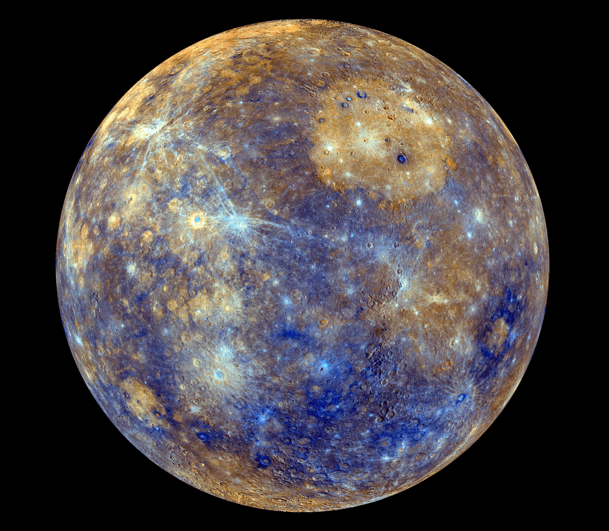
It’s always good to get a little change of perspective, and with this image we achieve just that: it’s a view of Mercury’s north pole projected as it might be seen from above a slightly more southerly latitude. Thanks to the MESSENGER spacecraft, with which this image was originally acquired, as well as the Arecibo Observatory here on Earth, scientists now know that these polar craters contain large deposits of water ice – which may seem surprising on an airless and searing-hot planet located so close to the Sun but not when you realize that the interiors of these craters never actually receive sunlight.

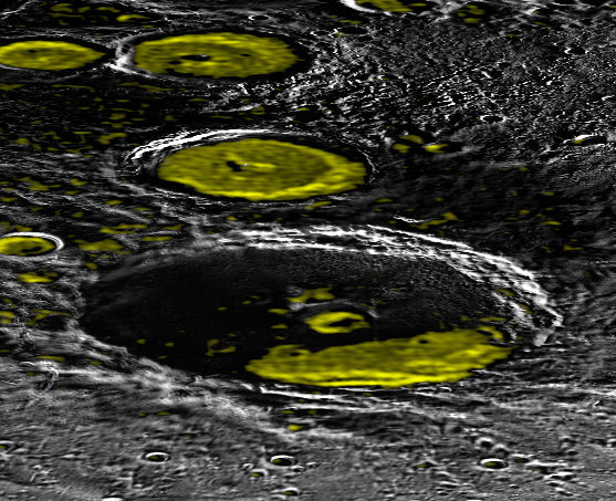
The locations of ice deposits are shown in the image in yellow. See below for a full-sized version.

Perspective view of Mercury's north pole made from MESSENGER MDIS data.
Perspective view of Mercury’s north pole made from MESSENGER MDIS images and Arecibo Observatory data. (NASA/Johns Hopkins University Applied Physics Laboratory/Carnegie Institution of Washington)

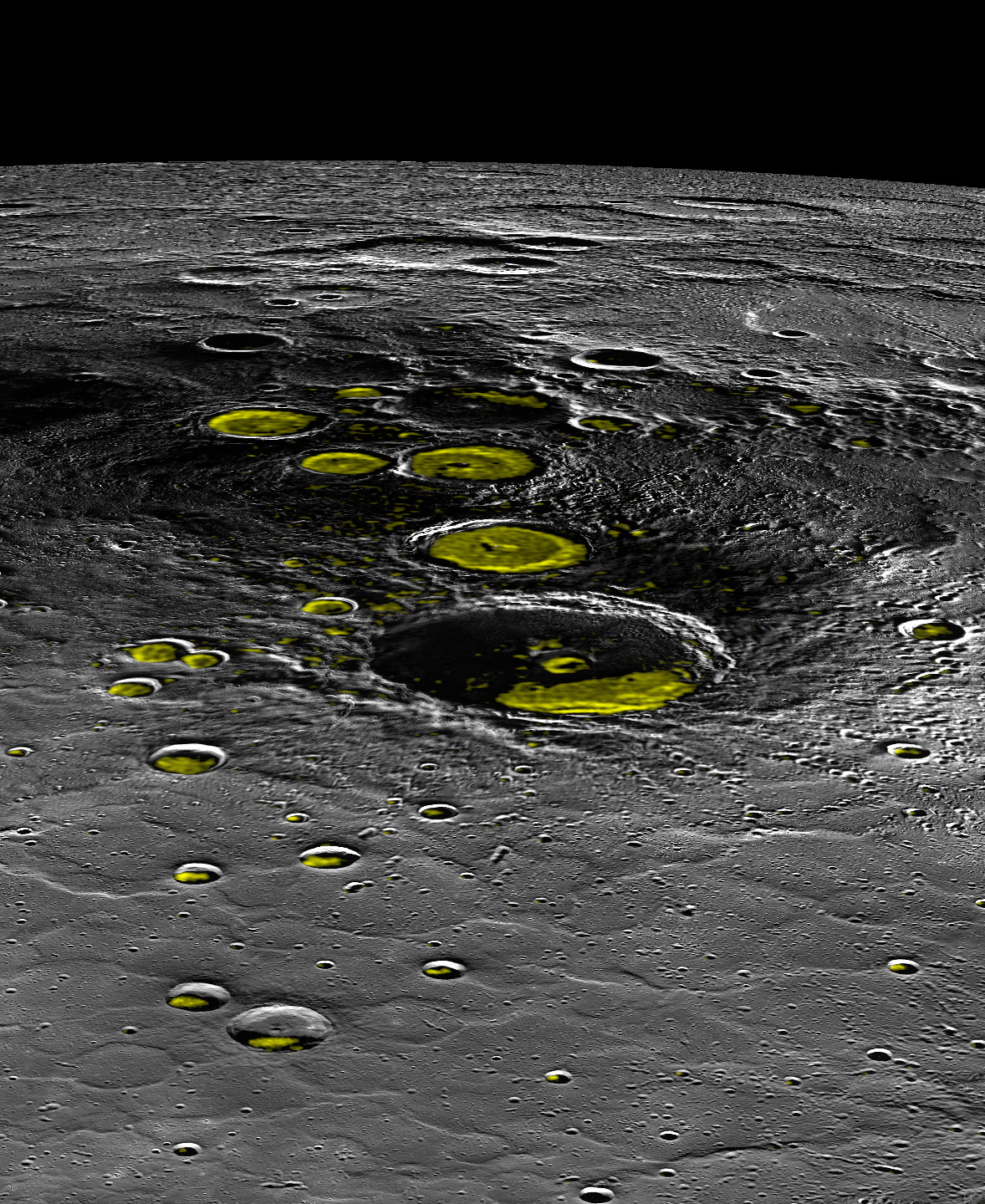
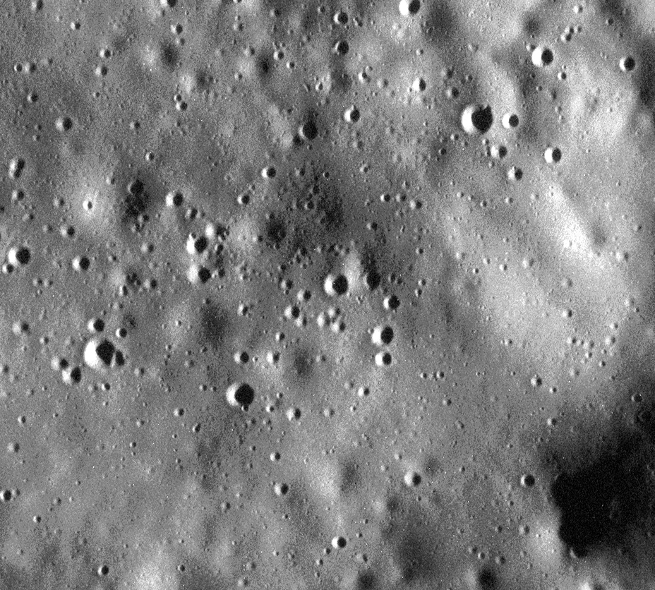
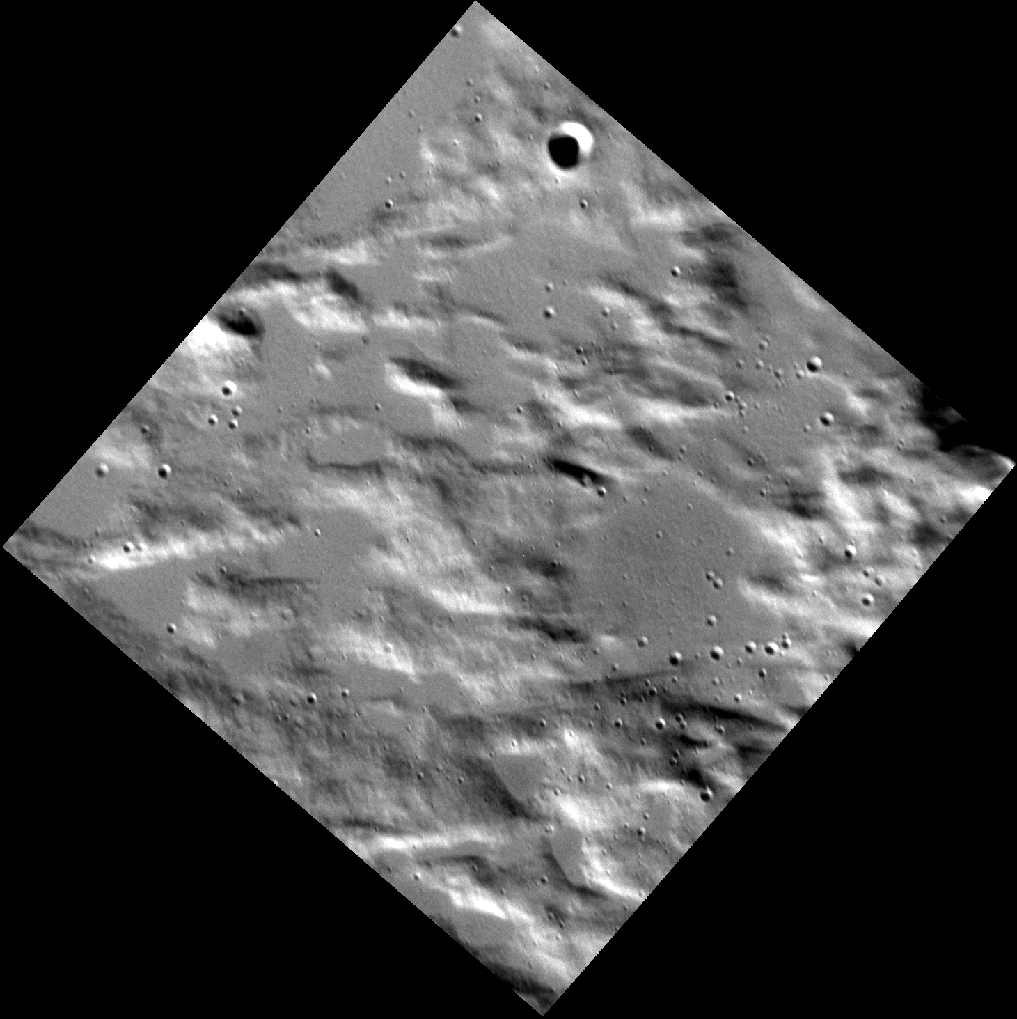
The five largest ice-filled craters in this view are (from front to back) the 112-km-wide Prokofiev and the smaller Kandinsky, Tolkien, Tryggvadottir, and Chesterton craters. A mosaic of many images acquired by MESSENGER’s Mercury Dual Imaging Sustem (MDIS) instrument during its time in orbit, you would never actually see a view of the planet’s pole illuminated like this in real life but orienting it this way helps put things into…well, perspective.

Radar observations from Arecibo showing bright areas on Mercury's north pole
Radar observations from Arecibo showing bright areas on Mercury’s north pole

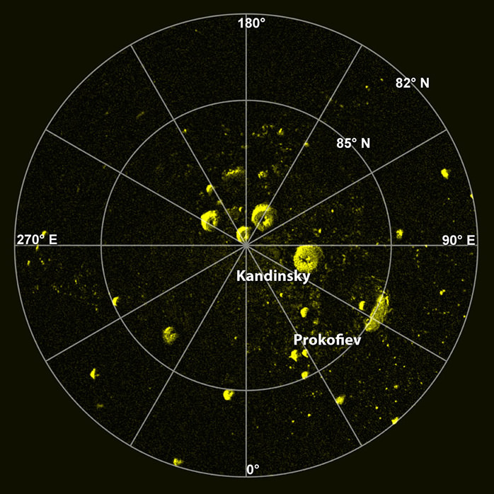
Radar-bright regions in Mercury’s polar craters have been known about since 1992 when they were first imaged from the Arecibo Observatory in Puerto Rico. Located in areas of permanent shadow where sunlight never reaches (due to the fact that Mercury’s axial tilt is a mere 2.11º, unlike Earth’s much more pronounced 23.4º slant) they have since been confirmed by MESSENGER observations to contain frozen water and other volatile materials.

Read more: Ice Alert! Mercury’s Deposits Could Tell Us More About How Water Came To Earth

Similarly-shadowed craters on our Moon’s south pole have also been found to contain water ice, although those deposits appear different in composition, texture, and age. It’s suspected that some of Mercury’s frozen materials may have been delivered later than those found on the Moon, or are being restored via an ongoing process. Read more about these findings here.

Explore Mercury’s shadowed craters with the Water Ice Data Exploration (WIDE) app

In orbit around Mercury since 2011, MESSENGER is now nearing the end of its operational life. Engineers have figured out a way to extend its fuel use for an additional month, possibly delaying its inevitable descent until April, but even if this maneuver goes as planned the spacecraft will be meeting Mercury’s surface very soon.

Source: MESSENGER

Mercury’s Ready For Its Close-Up, Mr. MESSENGER

One of the highest-resolution images of Mercury's surface ever acquired.

Are you ready for a good close look at Mercury? At an incredible 5 meters per pixel, this is one of the highest-resolution images of Mercury’s surface ever captured. It was acquired on March 15 with the MESSENGER spacecraft’s MDIS (Mercury Dual Imaging System) instrument and shows an 8.3-km (5.2-mile) -wide section of Mercury’s north polar region, speckled with small craters and softly rolling hills.

Because MESSENGER was moving so quickly relative to the targeted area it was imaging, a short exposure time was necessary to avoid blurring. As a result the image appears a bit grainy. See the original map projection here.

Wondering what the next-best image was of Mercury? Find out below:

The previous record for most extreme close-up of Mercury was held by this image:

7 meter/pixel targeted observation of Mercury by the MESSENGER spacecraft

It was acquired as a targeted observation by MESSENGER’s Narrow-Angle Camera on April 30, 2012, and has a resolution of 7 meters/pixel. It shows an impact melt-covered area about 11 km (7 miles) across near Gaugin crater.

(Although Mercury’s surface may at first appear strikingly similar to the Moon’s, it’s been known since the Mariner 10 mission that the two worlds are very different at fundamental geologic and compositional levels. Read more on that here.)

Images like these are extremely special; during the first two years of MESSENGER’s mission in orbit around Mercury, over 150,000 images were acquired but only five images had resolutions better than 10 meters per pixel.

Artist's impression of MESSENGER orbiting Mercury
Artist’s impression of MESSENGER orbiting Mercury

On April 20, 2014, MESSENGER completed its 3,000th orbit of Mercury (3,075 to date) and is steadily moving into an even lower-altitude orbit. MESSENGER now comes within less than 200 km (124 miles) of the planet’s surface when it passes over its north pole every eight hours… that’s less than half the altitude of the Space Station!

Orbiting at such a low altitude and so often will allow MESSENGER to examine Mercury’s surface in unprecedented detail. Now that 100% of the planet has been successfully mapped by MESSENGER it can spend its second — and last — extended mission investigating specific scientific targets.

Watch: A Tribute to MESSENGER 

“The final year of MESSENGER’s orbital operations will be an entirely new mission,” said Sean Solomon, Principal Investigator for MESSENGER. “With each orbit, our images, our surface compositional measurements, and our observations of the planet’s magnetic and gravity fields will be higher in resolution than ever before. We will be able to characterize Mercury’s near-surface particle environment for the first time. Mercury has stubbornly held on to many of its secrets, but many will at last be revealed.”

Read more in a recent news release from the MESSENGER team here.

Want to explore a high-res map of Mercury and see where MESSENGER is right now? Click here.

Image credits: NASA/Johns Hopkins University Applied Physics Laboratory/Carnegie Institution of Washington

Take a Spin Around Mercury

Color map of Mercury's varied surface. The 1,550-km-wide Caloris Basin can be seen at upper right.

Created by the MESSENGER mission team at the Johns Hopkins University Applied Physics Laboratory and the Carnegie Institution of Washington, this animation gives us a look at the spinning globe of Mercury, its surface color-coded to reflect variations in surface material reflectance.

Thousands of Wide Angle Camera images of Mercury’s surface were stitched together to create the full-planet views.

While the vibrant colors don’t accurately portray Mercury as our eyes would see it, they are valuable to scientists as they highlight the many different types of materials that make up the planet’s surface. Young crater rays surrounding fresh impact craters appear light blue or white. Medium- and dark-blue “low-reflectance material” (LRM) areas are thought to be rich in a dark, opaque mineral. Tan areas are plains formed by eruption of highly fluid lavas. Small orange spots are materials deposited by explosive volcanic eruptions.

At this point, over 99% of the Solar System’s innermost planet has been mapped by MESSENGER. Read more about the ongoing mission here.

Image/video credit: NASA/Johns Hopkins University Applied Physics Laboratory/Carnegie Institution of Washington