Dusty, Windy And Damp: Five NASA Probes To Hunt Down Climate Change in 2014

Artist's conception of NASA's Orbiting Carbon Observatory, which will examine carbon dioxide in the atmosphere (and its effect on climate change) after an expected launch in July 2014. Credit: NASA

How badly will climate change affect our planet? Different models tell us different things, and that’s partly because we need more precise information about the factors that warm the world. How much is sea level rising? What are the levels of carbon dioxide in the atmosphere? All of these things must be known.

NASA expects to launch five Earth science missions this year, which is the biggest roster in more than a decade. They’ll track rainfall, seek water hiding in soil, and examine carbon dioxide and ocean winds around the world. Here’s a quick rundown of the busy launch schedule:

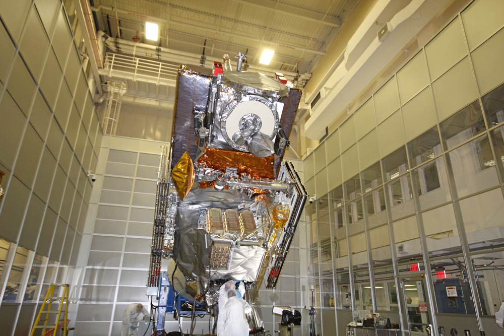
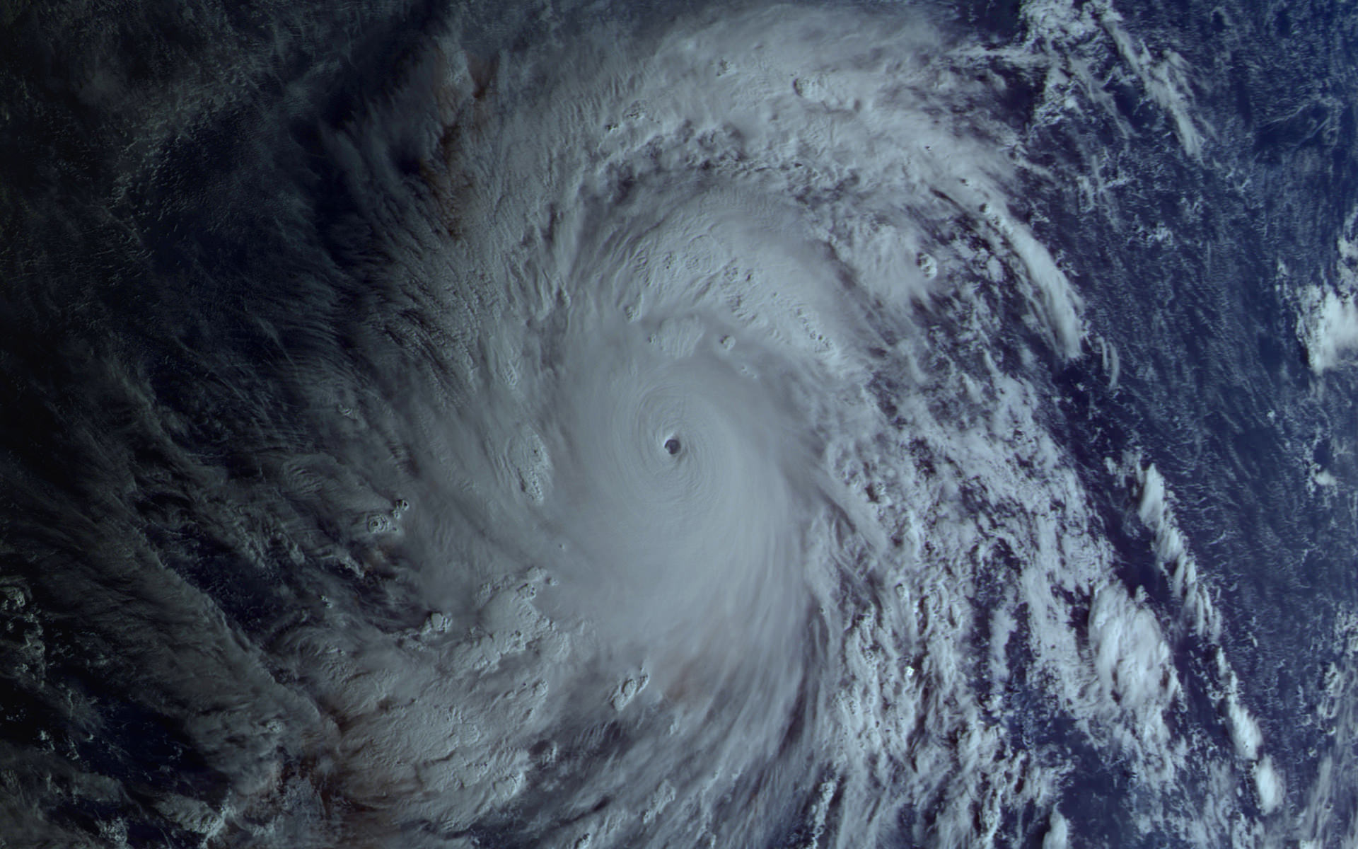
Global Precipitation Measurement (GPM) Core Observatory (Feb. 27): This will be the first of a series of satellites to look at snow and rain from space. “This new information will help answer questions about our planet’s life-sustaining water cycle, and improve water resource management and weather forecasting,” NASA stated. This joint spacecraft with the Japanese Aerospace Exploration Agency (JAXA) will launch from Japan’s Tanegashima Space Center on a H-IIA rocket. GPM was built at NASA’s Goddard Space Flight Center in Maryland.

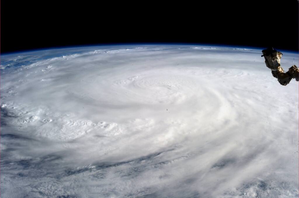
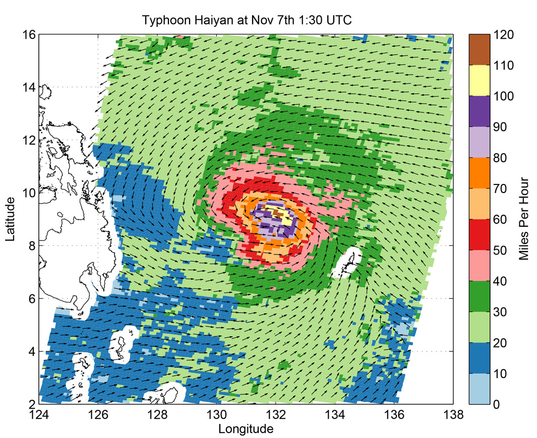
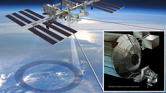
ISS-RapidScat (June 6): This sensor will sit on the International Space Station and monitor ocean winds (including storms and hurricanes). What’s interesting about this mission is its use of old parts, NASA points out, as well as the decision to mount it on a station rather than take the more expensive route of making it a separate satellite. The probe will launch on a SpaceX Dragon spacecraft (aboard a SpaceX Falcon 9 rocket) from Florida’s Cape Canaveral Air Force Station as part of a regular commercial resupply flight.

Artist's conception of how ISS-RapidScat will work. Credit: NASA/JPL-Caltech/Johnson Space Center
Artist’s conception of how ISS-RapidScat will work. Credit: NASA/JPL-Caltech/Johnson Space Center

Orbiting Carbon Observatory (OCO)-2 (July): NASA plans to take a second crack at this type of satellite after the OCO launch failure in 2009. The satellite will seek out carbon dioxide to better understand where it is emitted (in both natural and artificial processes) and how it moves through the water, air and land. This will launch from California’s Vandenberg Air Force Base on a Delta II rocket. OCO-2 will be managed by NASA’s Jet Propulsion Laboratory in California.

Cloud-Aerosol Transport System (CATS) (Sept. 12): This technology demonstration project will use lasers, in three wavelengths, to examine tiny particles borne into the atmosphere from phenomena such as pollution, smoke, dust and volcanoes. “These aerosol particles pose human health risks at ground level and influence global climate through their impact on cloud cover and solar radiation in Earth’s atmosphere,” NASA stated. This will also leave Earth aboard a SpaceX resupply flight from Cape Canaveral.

Soil Moisture Active Passive (SMAP) mission (November): Will check out the moisture level of soil, with the aim of refining “predictions of agricultural productivity, weather and climate,” NASA stated. Also managed by JPL, this satellite will spend its time in an almost-polar “sun-synchronous” orbit that keeps the sun’s illumination below constant during SMAP’s turns around the Earth. SMAP will launch from Vandenberg on a Delta II rocket.

Source: NASA

Super-Typhoon Haiyan Causes Catastrophic Death & Destruction – Space Images from NASA, ISRO, Roscosmos & ISS

Super Typhoon Haiyan over the Philippines on November 9, 2013 as imaged from Earth orbit by NASA Astronaut Karen Nyberg aboard the International Space Station. Credit: NASA/Karen Nyberg

Super Typhoon Haiyan over the Philippines on November 9, 2013 as imaged from Earth orbit by NASA Astronaut Karen Nyberg aboard the International Space Station.Category 5 killer storm Haiyan stretches across the entire photo from about 250 miles (400 kilometer) altitude. Credit: NASA/Karen Nyberg
See more Super Typhoon Haiyan imagery and video below
[/caption]

NASA GODDARD SPACE FLIGHT CENTER, MARYLAND – Super Typhoon Haiyan smashed into the island nation of the Philippines, Friday, Nov. 8, with maximum sustained winds estimated at exceeding 195 MPH (315 kilometer per hour) by the U.S. Navy Joint Typhoon Warning Center – leaving an enormous region of catastrophic death and destruction in its terrible wake.

The Red Cross estimates over 1200 deaths so far. The final toll could be significantly higher. Local media reports today say bodies of men, women and children are now washing on shore.

The enormous scale of Super Typhoon Haiyan can be vividly seen in space imagery captured by NASA, ISRO and Russian satellites – as well as astronaut Karen Nyberg flying overhead on board the International Space Station (ISS); collected here.

As Super-Typhoon Haiyan moved over the central Philippines on Nov. 8 at 05:10 UTC/12:10 a.m. EDT, the MODIS instrument aboard NASA's Aqua satellite captured this visible image.   Credit: NASA Goddard MODIS Rapid Response Team
As Super-Typhoon Haiyan moved over the central Philippines on Nov. 8 at 05:10 UTC/12:10 a.m. EDT, the MODIS instrument aboard NASA’s Aqua satellite captured this visible image. Credit: NASA Goddard MODIS Rapid Response Team

Super Typhoon Haiyan is reported to be the largest and most powerful storm ever to make landfall in recorded human history.

Haiyan is classified as a Category 5 monster storm on the U.S. Saffir-Simpson scale.

It struck the central Philippines municipality of Guiuan at the southern tip of the province of Eastern Samar early Friday morning Nov. 8 at 20:45 UTC (4:45 am local time).

As Haiyan hit the central Philippines, NASA says wind gusts exceeded 235 mph (379 kilometers per hour).

The high resolution imagery and precise measurements provided by the worlds constellation of Earth observing space satellites (including NASA, Roscosmos, ISRO, ESA, JAXA) are absolutely essential to tracking killer storms and providing significant advance warning to evacuate residents in affected areas to help minimize the death toll and damage.

More than 800,000 people were evacuated. The storm surge caused waves exceeding 30 feet (10 meters), mudslides and flash flooding.

NASA’s Tropical Rainfall Measuring Mission (TRMM) satellite captured visible, microwave and infrared data on the storm just as it was crossing the island of Leyte in the central Philippines, reports NASA – see image below.

NASA's TRMM satellite data on Nov. 8 at 00:19 UTC showed Haiyan had a well-defined eye surrounded by a symmetric area of moderate rain (green ring with a blue center) with several rainbands wrapping in from the south (green arcs) while crossing the island of Leyte in the central Philippines.  Credit:  NASA/SSAI, Hal Pierce
NASA’s TRMM satellite data on Nov. 8 at 00:19 UTC showed Haiyan had a well-defined eye surrounded by a symmetric area of moderate rain (green ring with a blue center) with several rainbands wrapping in from the south (green arcs) while crossing the island of Leyte in the central Philippines. Credit: NASA/SSAI, Hal Pierce

TRMM data from rain rates are measured by the TRMM Precipitation Radar (PR) and TRMM Microwave Imager (TMI) and combined with infrared (IR) data from the TRMM Visible Infrared Scanner (VIRS) by science teams working at NASA’s Goddard Space Flight Center in Greenbelt, Md.

Coincidentally NASA Goddard has just completed assembly of the next generation weather satellite Global Precipitation Measurement (GPM) observatory that replaces TRMM – and where I inspected the GPM satellite inside the Goddard clean room on Friday.

“GPM is a direct follow-up to NASA’s currently orbiting TRMM satellite,” Art Azarbarzin, GPM project manager, told Universe Today during my exclusive clean room inspection of the huge GPM satellite.

NASA’s next generation Global Precipation Managemnet Measurement (GPM) observatory inside the clean room at NASA Goddard Space Flight Center. GPM is slated to launch In February 2014 and will provide global measurements of rain and snow every 3 hours - as a direct follow-up to NASA’s currently orbiting TRMM satellite; reaching the end of its usable lifetime. Credit: Ken Kremer/kenkremer.com
NASA’s next generation Global Precipitation Measurement (GPM) observatory inside the clean room at NASA Goddard Space Flight Center. GPM is slated to launch In February 2014 and will provide global measurements of rain and snow every 3 hours – as a direct follow-up to NASA’s currently orbiting TRMM satellite; reaching the end of its usable lifetime.
Credit: Ken Kremer/kenkremer.com

“TRMM is reaching the end of its usable lifetime. GPM launches in February 2014 and we hope it has some overlap with observations from TRMM.”

“The Global Precipitation Measurement (GPM) observatory will provide high resolution global measurements of rain and snow every 3 hours,” Dalia Kirschbaum, GPM research scientist, told me at Goddard.

GPM is equipped with advanced, higher resolution radar instruments. It is vital to continuing the TRMM measurements and will help provide improved forecasts and advance warning of extreme super storms like Hurricane Sandy and Super Typhoon Haiyan, Azarbarzin and Kirschbaum explained.

Video Caption: Super Typhoon Haiyan imaged on Nov 6 – 8, 2013 by the Russian Elektro-L satellite operating in geostationary orbit. Credit: Roscosmos via Vitaliy Egorov

The full magnitude of Haiyan’s destruction is just starting to be assessed as rescue teams reach the devastated areas where winds wantonly ripped apart homes, farms, factories, buildings and structures of every imaginable type vital to everyday human existence.

Typhoon Haiyan is moving westward and is expected to forcefully strike central Vietnam in a day or two. Mass evacuations are underway at this time

Ken Kremer

SuperTyphoon Haiyan imaged by the Russian Elektro-L satellite operating in geostationary orbit. Credit: Roscosmos via Vitaliy Egorov
Super Typhoon Haiyan imaged by the Russian Elektro-L satellite operating in geostationary orbit. Credit: Roscosmos via Vitaliy Egorov
Super Typhoon Haiyan's ocean surface winds were measured by the OSCAT radar scatterometer on the Indian Space Research Organization's (ISRO) OceanSAT-2 satellite at 5:30 p.m. PST on Nov. 6. The colors indicate wind speed and arrows indicate wind direction. Credit: ISRO/NASA/JPL-Caltech
Super Typhoon Haiyan’s ocean surface winds were measured by the OSCAT radar scatterometer on the Indian Space Research Organization’s (ISRO) OceanSAT-2 satellite at 5:30 p.m. PST on Nov. 6. The colors indicate wind speed and arrows indicate wind direction. Credit: ISRO/NASA/JPL-Caltech

Getting to the Core of Earth’s Falling Snow

Visualization of the GPM Core Observatory and Partner Satellites. Credit: NASA

[/caption]

An international plan is unfolding that will launch satellites into orbit to study global snowfall precipitation with unprecedented detail. With the upcoming Global Precipitation Measurement (GPM) satellites, for the first time we will know when, where and how much snow falls on Earth, allowing greater understanding of energy cycles and how best to predict extreme weather.

Snow is more than just a pretty winter decoration… it’s also a very important contributor to fresh water supply in many regions around the world, especially those areas that rely on spring runoff from mountains.

The snowmelt from the Sierra Nevadas, for example, accounts for a third of the water supply for California.

But changing climate and recent drought conditions have affected how much snow the mountains receive in winter… and thus how much water is released in the spring. Unfortunately, as of now there’s no reliable way to comprehensively detect and measure falling snow from space… whether in the Sierras or the Andes or the Alps.

Engineers are building and testing the GPM Core Observatory at Goddard Space Flight Center. (NASA/GSFC)

The GPM Core satellite, slated to launch in 2014, will change that.

“The GPM Core, with its ability to detect falling snows, it’s one of the very first times that we’ve put sensors in space to specifically look at falling snow,” said GPM Deputy Project Scientist Gail Skofronick-Jackson in an online video. “We’re at that edge where rain was fifty years ago. We’re still figuring out how to measure snow.”

And why is snow such a difficult subject to study?

“Rain tends to be spherical like drops,” says Skofronick-Jackson. “But if you’ve ever been out in a snowfall and you’ve looked at your shirt, you see the snow comes in all different forms.”

Once GPM scientists calculate all the various types of snowflake shapes, the satellite will be able to detect them from orbit.

“The GPM Core, with its additional frequencies and information on the sensors, is going to be able to provide us for the first time a lot more information about falling snow than we’ve ever done before.”

Knowing where and how much snow and rain falls globally is vital to understanding how weather and climate impact both our environment and Earth’s energy cycles, including effects on agriculture, fresh water availability, and responses to natural disasters.

Snowfall is a missing part of the puzzle, and GPM will fill those pieces in.

Find out more about the GPM program at pmm.nasa.gov/GPM.

GPM Core is currently being assembled at NASA’s Goddard Space Flight Center and scheduled to launch in 2014 on a Japanese H-IIA rocket.  Initiated by NASA and the Japanese Aerospace Exploration Agency (JAXA), GPM consists of a consortium of international agencies, including the Centre National d’Études Spatiales (CNES), the Indian Space Research Organization (ISRO), the National Oceanic and Atmospheric Administration (NOAA), the European Organization for the Exploitation of Meteorological Satellites (EUMETSAT), and others.