Scientists Now Suspect More Sea Level Rise from Greenland’s Glaciers

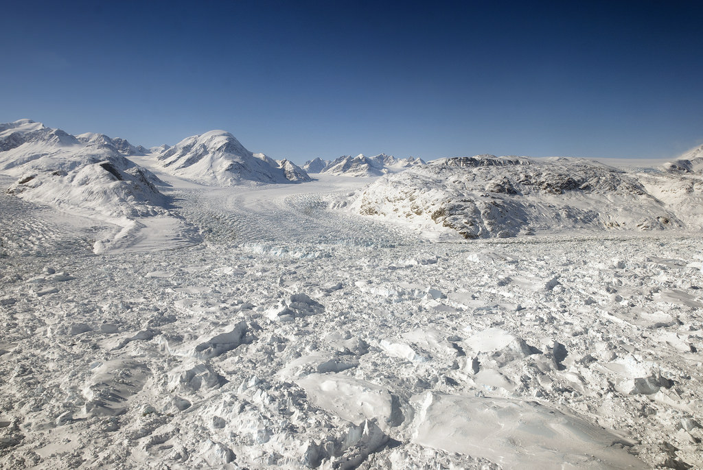
Floating ice at the calving front of Greenland's Kangerdlugssuaq glacier, photographed in 2011 during Operation IceBridge (Credit: NASA/Michael Studinger)

Greenland’s glaciers may contribute more to future sea level rise than once thought, despite earlier reports that their steady seaward advance is a bit slower than expected. This is just more sobering news on the current state of Earth’s ice from the same researchers that recently announced the “unstoppable” retreat of West Antarctic glaciers.

Using data collected by several international radar-mapping satellites and NASA’s airborne Operation IceBridge surveys, scientists at NASA and the University of California, Irvine have discovered deep canyons below the ice sheet along Greenland’s western coast. These canyons cut far inland, and are likely to drive ocean-feeding glaciers into the sea faster and for longer periods of time as Earth’s climate continues to warm.

Some previous models of Greenland’s glaciers expected their retreat to slow once they receded to higher altitudes, making their overall contribution to sea level increase uncertain. But with this new map of the terrain far below the ice, modeled with radar soundings and high-resolution ice motion data, it doesn’t seem that the ice sheets’ recession will halt any time soon.

According to the team’s paper, the findings “imply that the outlet glaciers of Greenland, and the ice sheet as a whole, are probably more vulnerable to ocean thermal forcing and peripheral thinning than inferred previously from existing numerical ice-sheet models.”

Read more: Scientists Set Their Sights on Arctic Ice Loss

Watch a video of the new topography map below:

“The glaciers of Greenland are likely to retreat faster and farther inland than anticipated, and for much longer, according to this very different topography we have discovered. This has major implications, because the glacier melt will contribute much more to rising seas around the globe.

– Mathieu Morlighem, project scientist, University of California, Irving

Many of the newly-discovered canyons descend below sea level and extend over 65 miles (100 kilometers) inland, making them vulnerable — like the glaciers in West Antarctica — to undercutting by warmer ocean currents.

The team’s findings were published on May 18 in a report titled Deeply Incised Submarine Glacial Valleys Beneath the Greenland Ice Sheet in the journal Nature Geoscience.

Source: NASA/JPL press release & University of California,Irvine News

_______________

What would happen if all the ice on land melted into the ocean? Find out what the world would look like here.

Meet GROVER the Rover, Set For Greenland Exploration

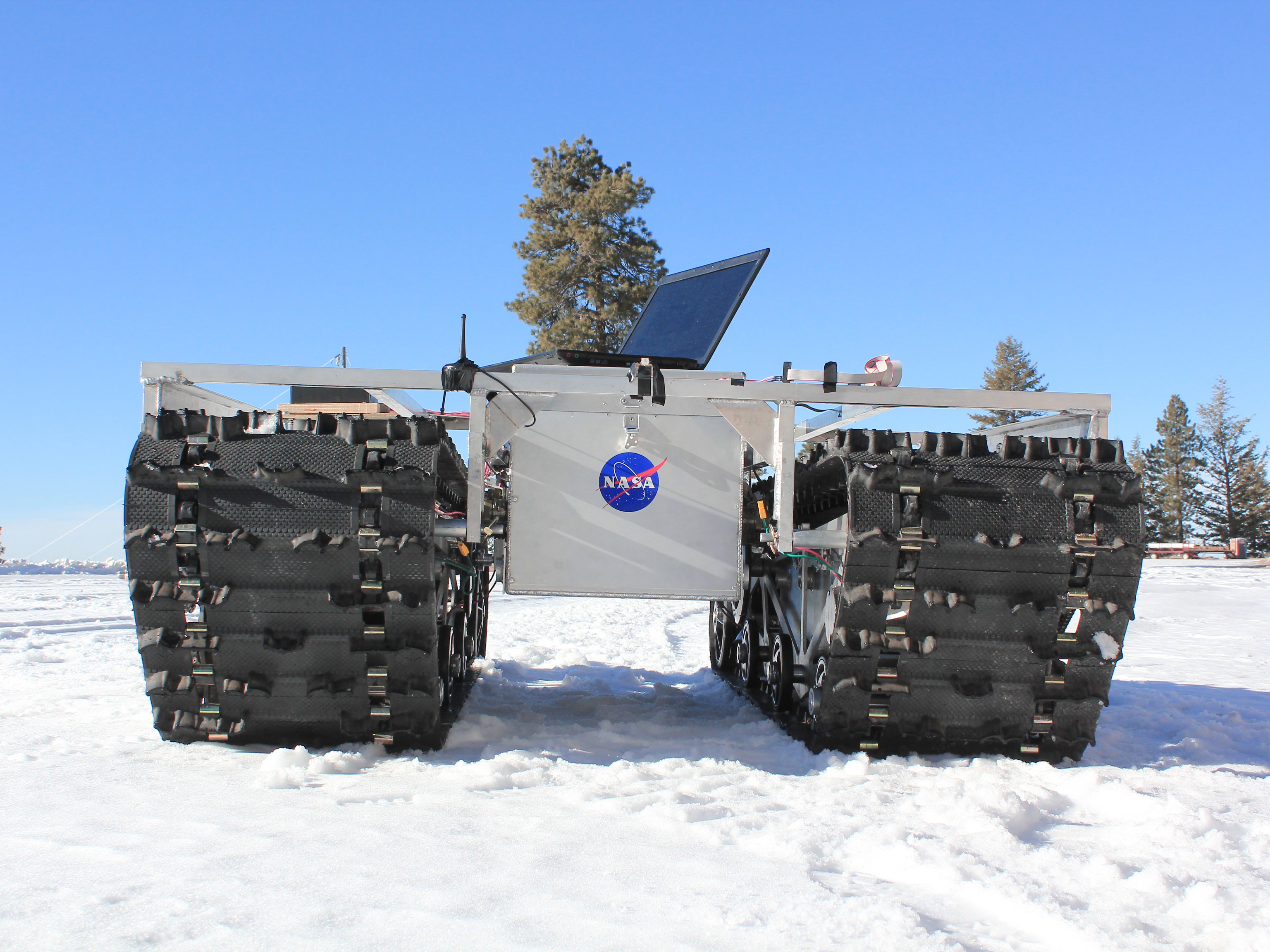
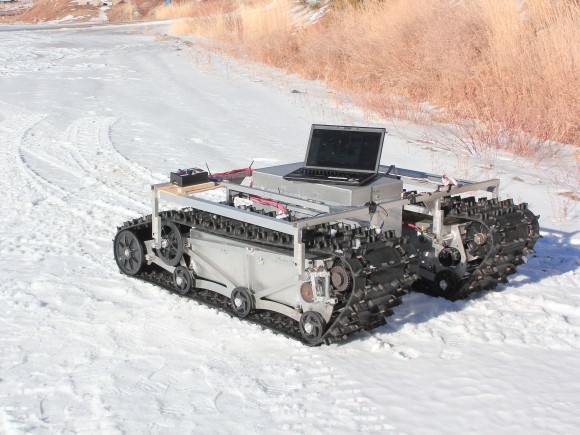
A GROVER prototype during testing in January 2013. Credit: Gabriel Trisca, Boise State University

How fast is Greenland’s ice sheet melting in response to climate change, and how is it recovering? A new NASA rover with the friendly name of GROVER (Greeland Rover and Goddard Remotely Operated Vehicle for Exploration and Research) is going to try to figure that out.

GROVER will rove across a small area of the massive ice sheet at a location called Summit Camp, which is a National Science Foundation outpost. On board it has ground-penetrating radar that is intended to figure out how the snow builds up in layers through time.

“Robots like GROVER will give us a new tool for glaciology studies,” stated Lora Koenig, a glaciologist at Goddard and science advisor on the project.

A prototype of GROVER during testing in January 2012. The rover does not have its solar panels attached here. The laptop was used as part of that specific test only. Credit: Gabriel Trisca, Boise State University

The student-designed project came to be during development phases in 2010 and 2011, principally at Boise State University in Idaho. At six feet tall, it’s way more massive than its Sesame Street namesake: it tips the scale at 800 pounds, including solar panels, and has two snowmobile tracks built in to move around.

“GROVER is just like a spacecraft but it has to operate on the ground,” stated Michael Comberiate, a retired NASA engineer and manager of Goddard’s Engineering Boot Camp.

“It has to survive unattended for months in a hostile environment, with just a few commands to interrogate it and find out its status and give it some directions for how to accommodate situations it finds itself in.”

Studies began on May 3 and will continue through June 8.

Source: NASA

Ancient Antarctic Ice Sampled In Lake Vostok Drill

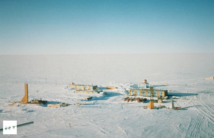
Panoramic photo of Vostok Station showing the layout of the camp. Credit: Todd Sowers LDEO, Columbia University, Palisades, New York (Image from physorg.com)

[/caption]

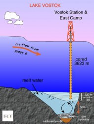
Sealed off for millions of years beneath an almost impenetrable layer of ice, Lake Vostok has kept a vast archive of ancient history waiting for just the right moment to reveal itself. Here is a unique closed ecosystem captured in time below four kilometers of ice. Saved from environmental contamination, its water has been isolated from Earth’s atmosphere, and the outside world, long before man existed. Only one burning question remains… Could this pristine pocket of Lake Vostok show signs of early life?

“According to our research, the quantity of oxygen there exceeds that on other parts of our planet by 10 to 20 times. Any life forms that we find are likely to be unique on Earth,” says Sergey Bulat, the Chief Scientist of Russia’s Antarctic Expedition to Russian Reporter magazine.

So why be so excited over finding a few organisms? The reason is clear as the hidden waters. If a life form could exist here, it could also exist on a similar world…. Jupiter’s satellite, Europa.

“The discovery of microorganisms in Lake Vostok may mean that, perhaps, the first meeting with extra-terrestrial life could happen on Europa,” said Dr Vladimir Kotlyakov, Director of the Geography Institute at the Russian Academy of Sciences to Vzglyad newspaper.

Image from earth.columbia.edu
However, drilling through over 3,700 meters of pure ice hasn’t been an easy process – especially when you’re working in temperatures as low as minus 80 centigrade. The chill thrill drill began in 1970, but it was over 25 years later before Russian specialists discovered the hidden lake beneath the ice sheet. Along with British support, they then began sonar and satellite imagining to reveal one of the world’s largest undisclosed fresh water reservoirs. Now, speculation began in earnest. What might these waters contain? Could it be tiny microbes? Or perhaps even a dangerous organism… There was only one way to find out. Drill and sample.

“Everything but the samples themselves will be carefully decontaminated using radiation. There is no need to worry,” Valeriy Lukin, Head of the Antarctic Expedition told Russian Reporter Magazine. According to researchers at the Russian Arctic and Antarctic Research Institute, they surmise the findings as “the only giant super-clean water system on the planet.” and pristine water will be “twice cleaner than double-distilled water.”

Over the last few decades, there had been a lot of discord over anti-freeze drilling methods – each with its pros and cons. From kerosene to Freon – even hot water – the end result needed to be the same. No chance of contamination… either to the samples or the native environment. As it ended up, the Russian method of using the former turned out to be fine when 40 liters of frozen, pure water came to light on February 4. Just a day later, 1,500 liters of kerosene and Freon poured into special containers with no problems and the sample proved to be immaculate. The clear waters are now safely tucked away in sterile containers and are heading back home.

“I can say that everyone at Bellingshausen on the Antarctic Peninsula could probably tell you down to the meter what the daily progress of the drilling was at the Vostok Station in the center of the continent.” says reporter, Sean Thomas. ” After all, the work at Lake Vostok was a Russian project, at a Russian base with Russian scientists, so there is a lot of pride in the work that is being done there.”

Original Story Source: RT News.

New Study Reveals Little Ice Age Triggered By Volcanism

Gifford Miller collects vegetation samples on Baffin Island. (Photo courtesy University of Colorado Boulder.)

[/caption]

In a study led by the University of Colorado Boulder with co-authors at the National Center for Atmospheric Research (NCAR) and other organizations, researchers may have possibly found evidence the “Little Ice Age” may have had ties to an unusual era of volcanic activity… one that lasted for about 50 years. In just five decades, four massive tropical volcanic eruptions managed to take Earth’s entire environment and put it on ice. Somewhere near the years between 1275 and 1300 A.D., these eruptions caused some very cool summer weather in the northern hemisphere which triggered an expansion of sea ice that – in turn – weakened Atlantic currents. However, it didn’t weaken the already cool climate. It strengthened it.

The international study was done in layers – like a good cake – but instead of sweet frosting, it was a composite look at dead vegetation, ice and sediment core data. By engaging highly detailed computer climate modeling, scientists are now able to have a strong theory of what triggered the Little Ice Age.. a theory which begins with decreased summer solar radiation and progresses through erupting volcanoes. Here planet-wide cooling could have been started by sulfates and other aerosols being ejected into our atmosphere and reflecting sunlight back into space. Simulations have shown it could have even been a combination of both scenarios.

“This is the first time anyone has clearly identified the specific onset of the cold times marking the start of the Little Ice Age,” says lead author Gifford Miller of the University of Colorado Boulder. “We also have provided an understandable climate feedback system that explains how this cold period could be sustained for a long period of time. If the climate system is hit again and again by cold conditions over a relatively short period—in this case, from volcanic eruptions—there appears to be a cumulative cooling effect.”

“Our simulations showed that the volcanic eruptions may have had a profound cooling effect,” says NCAR scientist Bette Otto-Bliesner, a co-author of the study. “The eruptions could have triggered a chain reaction, affecting sea ice and ocean currents in a way that lowered temperatures for centuries.” The team’s research papers will be published this week in Geophysical Research Letters. Members of the group include co-authors from the University of Iceland, the University of California Irvine, and the University of Edinburgh in Scotland. The study was funded in part by the National Science Foundation, NCAR’s sponsor, and the Icelandic Science Foundation.

“Scientific estimates regarding the onset of the Little Ice Age range from the 13th century to the 16th century, but there is little consensus,” Miller says. It’s fairly clear these lower temperatures had an impact on more southerly regions such as South American and China, but the effect was far more clear in areas such as northern Europe. Glacial movement eradicated populated regions and historical images show people ice skating in places known to be too warm for such solid freezing activities before the Little Ice Age.

“The dominant way scientists have defined the Little Ice Age is by the expansion of big valley glaciers in the Alps and in Norway,” says Miller, a fellow at CU’s Institute of Arctic and Alpine Research. “But the time in which European glaciers advanced far enough to demolish villages would have been long after the onset of the cold period.”

By employing the technique of radiocarbon dating, approximately 150 plant specimens, complete with roots, were gathered from the receding edges of ice caps located on Baffin Island in the Canadian Artic. In these samples they found evidence of a “kill date” which ranged between 1275 and 1300 A.D. This information led the team to surmise the plants were quickly frozen and then just as quickly encased in solid ice. A second documented kill date occurred about 1450 A.D. showing another major event. To further flesh out their findings, the research team took sediment sample cores from a glacial lake which is linked to the mile-high Langikull ice cap. These important samples from Iceland can be reliably dated back as far as 1,000 years and the results showed a sudden increase in ice during the late 13th century and again in the 15th. Thanks to these techniques which rely on the presence tephra deposits, we know these climate cooling events occurred as a result of volcanic eruptions.

“That showed us the signal we got from Baffin Island was not just a local signal, it was a North Atlantic signal,” Miller says. “This gave us a great deal more confidence that there was a major perturbation to the Northern Hemisphere climate near the end of the 13th century.”

What brought the team to their final conclusions? Through the use of the Community Climate System Model developed by scientists at NCAR and the Department of Energy with colleagues at other organizations, they were able to simulate the impact of volcanic cooling on the extent and mass of Artic sea ice. The model painted a portrait of what could have occurred from about 1150 to 1700 A.D. and showed that some large scale eruptions could have impacted the northern hemisphere if they happened within a close time frame. In this scenario, the long term cooling effect could have expanded the Artic Sea ice to the point where it eventually met – and melted – in the North Atlantic. During the modeling, the solar radiation was set at a constant to show ” the Little Ice Age likely would have occurred without decreased summer solar radiation at the time.” concluded Miller.

Original Story Source: Univsersity Corporation for Atmospheric Research.

Mars Was Recently Blanketed By Glaciers

Mars is a dead world, unchanging for billions of years. Right? Maybe not. Researchers from Brown University have found evidence for thick, recurring glaciers on the surface of Mars. This means that the climate on Mars might be much more dynamic than previously believed. Perhaps the climate could change again. And liquid water underneath these glaciers might have given life a refuge over the eons.

Around 3.5 billion years ago, Mars was a completely different world, with liquid water right there on its surface. And then something happened that made it cold, dry, and quiet – too quiet. Apart from the occasional meteorite impact, planetary geologists thought that very little has happened on Mars since then.

In an article published in the journal Geology, scientists from Brown University released images showing how dynamic Mars might be. They found evidence that thick ice packs, at least 1 km (0.6 miles) thick and maybe 2.5 km (1.6 miles) thick coated Mars’ mid-latitude regions.

These ice sheets weren’t there last year, but they were there 100 million years ago, and maybe localized glaciers were flowing as recently as 10 million years ago. That’s yesterday, geologically speaking.

With activity this recent on Mars, that could mean that its climate might change often, and it could happen again. Maybe Mars wasn’t so dead for the last 3.5 billion years.

The images captured by NASA’s Mars Reconnaissance Orbiter showed a box canyon in a low-lying plain. The canyon clearly has moraines – deposits of rock that mark the end of the glacier, or the path of its retreat.

This discovery increases the possibility of life on the surface of Mars. At the bottom of the glaciers, crushed under kilometres of ice, liquid water would have formed into vast reservoirs. These could have served as sanctuaries for life.

Original Source: Brown University News Release