Image of the Multi-Purpose Habitat (MPH) being developed through a recent partnership between the Italian Space Agency and Thales Alenia Space. (Credit: Thales Alenia Space)
With NASA gearing up to send humans back to the Moon in the next few years with the Artemis missions with the goal of establishing a permanent outpost at the lunar south pole, nations are making efforts to contribute to Artemis and a permanent presence on our nearest celestial neighbor. Recently, the Italian Space Agency, formally known as Agenzia Spaziale Italiana (ASI), has taken steps to establish the first permanent outpost on the lunar surface, known simply as the Multi-Purpose Habitat (MPH). This endeavor was officially kicked by the ASI signing a contract with the French-based aerospace company, Thales Alenia Space, who specializes in space-based systems, including ground segments and satellites used for both Earth observation and space exploration.
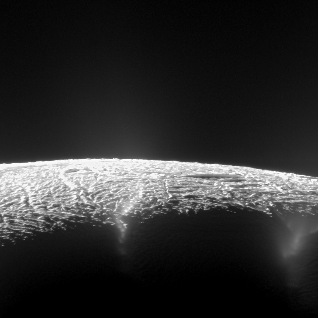
This dramatic view looks across the region of Enceladus' geyser basin and down on the ends of the Baghdad and Damascus fractures that face Saturn. The image, which looks approximately in the direction of Saturn, was taken from a more elevated viewpoint than other Cassini survey images of this area of the moon's south pole. Credit: NASA/JPL-Caltech/SSI
Scientists analyzing the reams of data from NASA’s Cassini orbiter at Saturn have discovered 101 geysers erupting from the intriguing icy moon Enceladus and that the spewing material of liquid water likely originates from an underground sea located beneath the tiny moons ice shell, according to newly published research.
The geysers are composed of tiny icy particles, water vapor and trace amounts of simple organic molecules. They were first sighted in Cassini imagery snapped during flyby’s of the 310-mile-wide (500 kilometers wide) moon back in 2005 and immediately thrust Enceladus forward as a potential abode for alien life beyond Earth and prime scientific inquisition.
Liquid water, organic molecules and an energy source are the key requirements for life as we know it.
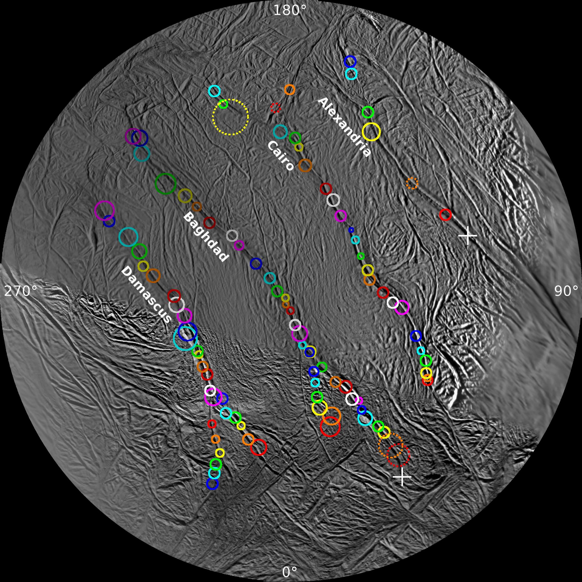
The eruptions emanated from a previously unknown network of four prominent “tiger stripe” fractures, named Damascus, Baghdad, Cairo and Alexandria sulci, located at the south polar region of Saturn’s sixth largest moon.
Using imagery gathered over nearly seven years of surveys by Cassini’s cameras, researchers generated a survey map of the 101 geysers erupting from the four tiger strips.
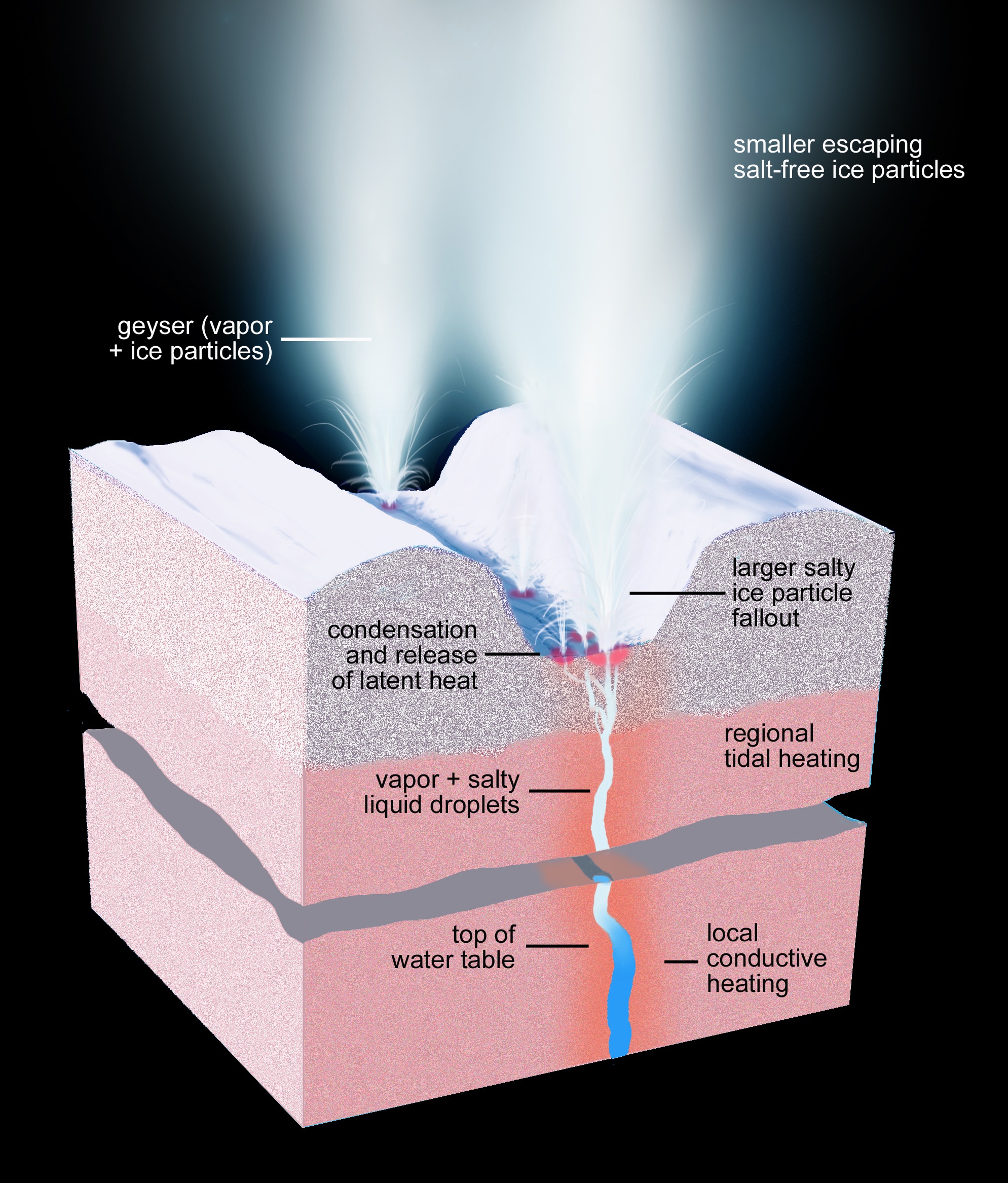
This artist’s rendering shows a cross-section of the ice shell immediately beneath one of Enceladus’ geyser-active fractures, illustrating the physical and thermal structure and the processes ongoing below and at the surface. Image Credit: NASA/JPL-Caltech/Space Science Institute
The new findings and theories on the physical nature of how the geysers erupt have been published in two articles in the current online edition of the Astronomical Journal.
Scientists had initially postulated that the origin of the geysers could be frictional heating generated from back and forth rubbing of the opposing walls of the tiger stripe fractures that converted water ice into liquids and vapors. Another theory held that the opening and closing of the fractures allowed water vapor from below to reach the surface.
The geysers locations was eventually determined to coincide with small local hot spots erupting from one of the tiger stripe fractures after researchers compared low resolution thermal emission maps with the geysers’ locations and found the greatest activity at the warmest spots.
After later high-resolution data was collected in 2010 by Cassini’s heat-sensing instruments the geysers were found to coincide with small-scale hot spots, measuring only a few dozen feet (or tens of meters) across.
“Once we had these results in hand we knew right away heat was not causing the geysers, but vice versa,” said Carolyn Porco, leader of the Cassini imaging team from the Space Science Institute in Boulder, Colorado, and lead author of the first paper. “It also told us the geysers are not a near-surface phenomenon, but have much deeper roots.”
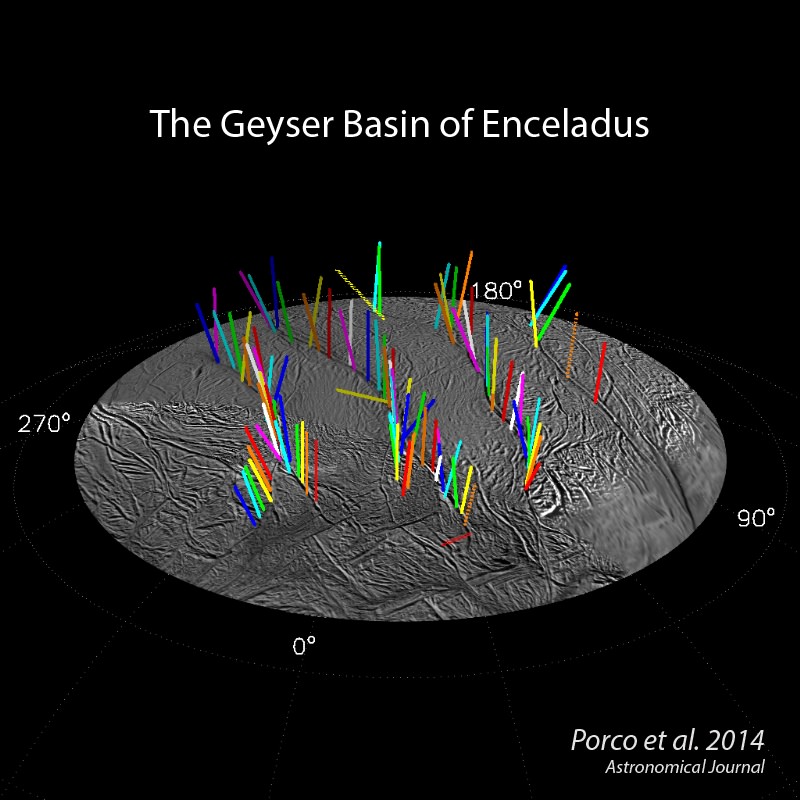
This graphic shows a 3-D model of 98 geysers whose source locations and tilts were found in a Cassini imaging survey of Enceladus’ south polar terrain by the method of triangulation. While some jets are strongly tilted, it is clear the jets on average lie in four distinct “planes” that are normal to the surface at their source location. Image credit: NASA/JPL-Caltech/Space Science Institute
“Thanks to recent analysis of Cassini gravity data, the researchers concluded the only plausible source of the material forming the geysers is the sea now known to exist beneath the ice shell. They also found that narrow pathways through the ice shell can remain open from the sea all the way to the surface, if filled with liquid water,” according to a NASA press release.
These are very exciting results in the search for life beyond Earth and clearly warrant a follow up mission.
“In casting your sights on the geysering glory of Enceladus, you are looking at frozen mist that originates deep within the solar system’s most accessible habitable zone,” writes Porco in her Captain’s Log summary of the new findings.
Surveyor’s Map of Enceladus’ Geyser Basin – On this polar stereographic map of Enceladus’ south polar terrain, all 101 geysers have been plotted whose source locations have been determined in Cassini’s imaging survey of the moon’s geyser basin. Credit: NASA/JPL-Caltech/SSI
The Cassini-Huygens mission is a cooperative project between NASA, the European Space Agency (ESA) and the Italian Space Agency (ASI). Cassini was launched by a Titan IV rocket in 1997 and arrived at Saturn in 2004.
In 2005 Cassini deployed the Huygens probe which landed on Titan, Saturn’s largest moon sporting oceans of organic molecules and another prime location in the search for life.
The Cassini mission will conclude in 2017 with an intentional suicide dive into Saturn to prevent contamination on Titan and Enceladus – but lots more breathtaking science will be accomplished in the meantime!
Stay tuned here for Ken’s Earth & Planetary science and human spaceflight news.
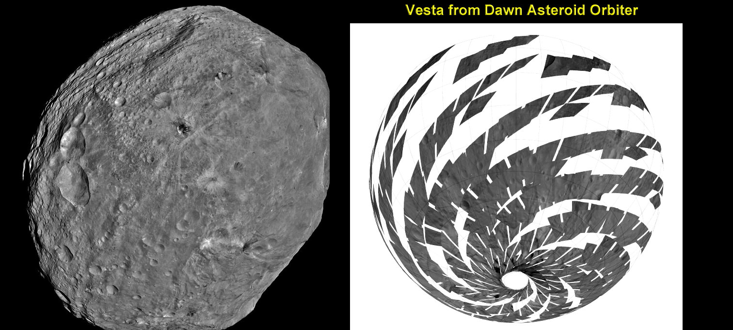
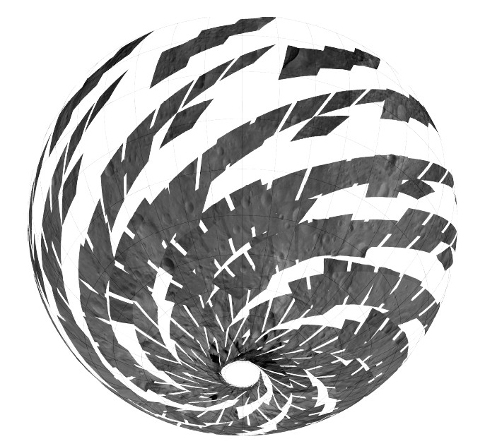
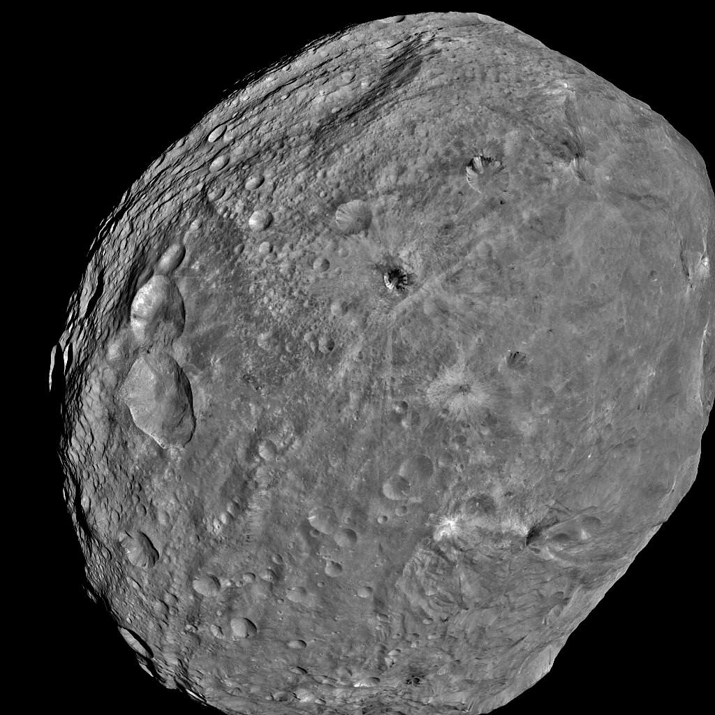
Vesta imaged by NASA’s Dawn Asteroid Orbiter. Dawn is currently at work at the Low Altitude Mapping Orbit (LAMO) acquiring new imagery and spectra of much higher resolution compared to these images acquired at higher altitudes and is also filling in gaps of surface data. The image from Dawn’s Framing Camera, at left, was taken on July 24 at a distance of 3,200 miles soon after achieving orbit around Vesta. The mosaic from Dawn’s Visible and infrared spectrometer (VIR), at right, was acquired from High-altitude mapping orbit (HAMO). Credit: NASA/ JPL-Caltech/ UCLA/ ASI/ INAF/ IAPS. Collage: Ken Kremer
[/caption]
NASA’s Dawn mission is getting a whopping boost in science observing time at the closest orbit around Asteroid Vesta as the probe passes the midway point of its 1 year long survey of the colossal space rock. And the team informs Universe Today that the data so far have surpassed all expectations and they are very excited !
Dawn’s bonus study time amounts to an additional 40 days circling Vesta at the highest resolution altitude for scientific measurements. That translates to a more than 50 percent increase beyond the originally planned length of 70 days at what is dubbed the Low Altitude Mapping Orbit, or LAMO.
“We are truly thrilled to be able to spend more time observing Vesta from low altitude,” Dr. Marc Rayman told Universe Today in an exclusive interview. Rayman is Dawn’s Engineer at NASA’s Jet Propulsion Laboratory (JPL) in Pasadena, Calif.
“It is very exciting indeed to obtain such a close-up look at a world that even a year ago was still just a fuzzy blob.”
The big extension for a once-in-a-lifetime shot at up close science was all enabled owing to the hard work of the international science team in diligently handling any anomalies along the pathway through interplanetary space and since Dawn achieved orbit in July 2011, as well as to the innovative engineering of the spacecraft’s design and its revolutionary ion propulsion system.
“This is a reflection of how well all of our work at Vesta has gone from the beginning of the approach phase in May 2011,” Rayman told me.
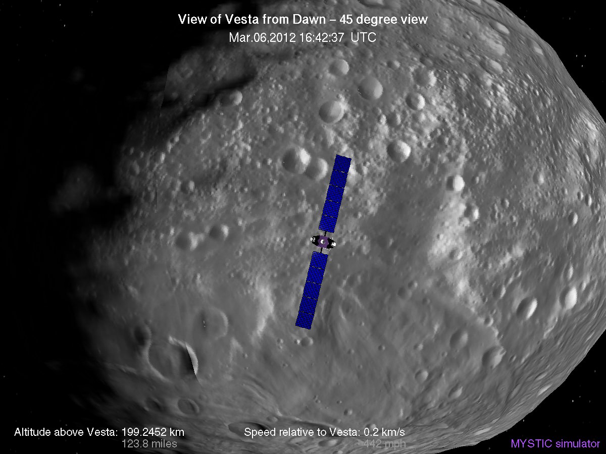
Simulated view of Vesta from Dawn in LAMO, low altitude mapping orbit - March, 6 2012
Credit: Gregory J. Whiffen, JPL
Dawn’s initially projected 10 week long science campaign at LAMO began on Dec. 12, 2011 at an average distance of 210 kilometers (130 miles) from the protoplanet and was expected to conclude on Feb. 20, 2012 under the original timeline. Thereafter it would start spiraling back out to the High Altitude Mapping Orbit, known as HAMO, approximately 680 kilometers above the surface.
“With the additional 40 days it means we are now scheduled to leave LAMO on April 4. That’s when we begin ion thrusting for the transfer to HAMO2,” Rayman stated.
And the observations to date at LAMO have already vastly surpassed all hopes – using all three of the onboard science instruments provided by the US, Germany and Italy.
“Dawn’s productivity certainly is exceeding what we had expected,” exclaimed Rayman.
“We have acquired more than 7500 LAMO pictures from the Framing Camera and more than 1 million LAMO VIR (Visible and Infrared) spectra which afford scientists a much more detailed view of Vesta than had been planned with the survey orbit and the high altitude mapping orbit (HAMO). It would have been really neat just to have acquired even only a few of these close-up observations, but we have a great bounty!”
“Roughly around half of Vesta’s surface has been imaged at LAMO.”
Dawn mosaic of Visible and Infrared spectrometer (VIR) data of Vesta
This mosaic shows the location of the data acquired by VIR (visible and infrared spectrometer) during the HAMO (high-altitude mapping orbit) phase of the Dawn mission from August to October 2011. Dawn is now making the same observations at the now extended LAMO (low-altitude mapping orbit) phase of the Dawn mission from December 2011 to April 2012. VIR can image Vesta in a number of different wavelengths of light, ranging from the visible to the infrared part of the electromagnetic spectrum. This mosaic shows the images taken at a wavelength of 550 nanometers, which is in the visible part of the electromagnetic spectrum. During HAMO VIR obtained more than 4.6 million spectra of Vesta. It is clear from this image that the VIR observations are widely distributed across Vesta, which results in a global view of the spectral properties of Vesta’s surface. This image shows Vesta’s southern hemisphere (lower part of the image) and equatorial regions (upper part of the image). NASA’s Dawn spacecraft obtained these VIR images with its visible and infrared spectrometer in September and October 2011. The distance to the surface of Vesta is around 700 kilometers (435 miles) and the average image resolution is 170 meters per pixel. Credit: NASA/ JPL-Caltech/ UCLA/ ASI/ INAF/ IAPS
The bonus time at LAMO will now be effectively used to help fill in the gaps in surface coverage utilizing all 3 science instruments. Therefore perhaps an additional 20% to 25% extra territory will be imaged at the highest possible resolution. Some of this will surely amount to enlarged new coverage and some will be overlapping with prior terrain, which also has enormous research benefits.
“There is real value even in seeing the same part of the surface multiple times, because the illumination may be different. In addition, it helps for building up stereo,” said Rayman.
Researchers will deduce further critical facts about Vesta’s topography, composition, interior, gravity and geologic features with the supplemental measurements.
Successive formation of impact craters on Vesta
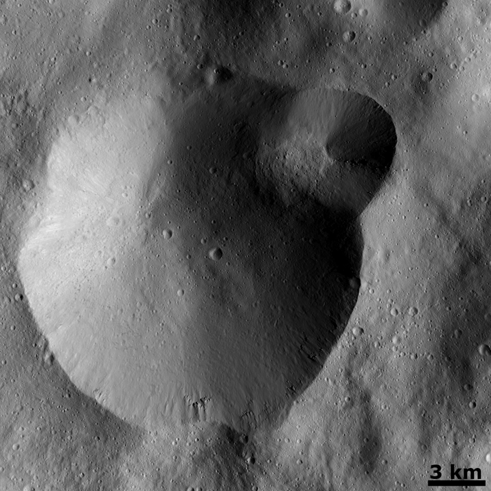
This Dawn FC (framing camera) image shows two overlapping impact craters and was taken on Dec. 18,2011 during the LAMO (low-altitude mapping orbit) phase of the mission. The large crater is roughly 20 kilometers (12 miles) in diameter and the smaller crater is roughly 6 kilometers (4 miles) in diameter. The rims of the craters are both reasonably fresh but the larger crater must be older because the smaller crater cuts across the larger crater’s rim. As the smaller crater formed it destroyed a part of the rim of the pre-existing, larger crater. The larger crater’s interior is more densely cratered than the smaller crater, which also suggests that is it older. In the bottom of the image there is some material slumping from rim of the larger crater towards its center. This image with its framing camera on Dec. 18, 2011. This image was taken through the camera’s clear filter. The distance to the surface of Vesta is 260 kilometers (162 miles) and the image has a resolution of about 22 meters (82 feet) per pixel. Credit: NASA/ JPL-Caltech/ UCLA/ MPS/ DLR/ IDA
The foremost science goals at LAMO are collection of gamma ray and neutron measurements with the GRaND instrument – which focuses on determining the elemental abundances of Vesta – and collection of information about the structure of the gravitational field. Since GRaND can only operate effectively at low orbit, the extended duration at LAMO takes on further significance.
“Our focus is on acquiring the highest priority science. The pointing of the spacecraft is determined by our primary scientific objectives of collecting GRaND and gravity measurements.”
As Dawn continues orbiting every 4.3 hours around Vesta during LAMO, GRaND is recording measurements of the subatomic particles that emanate from the surface as a result of the continuous bombardment of cosmic rays and reveals the signatures of the elements down to a depth of about 1 meter.
“You can think of GRaND as taking a picture of Vesta but in extremely faint light. That is, the nuclear emissions it detects are extremely weak. So our long time in LAMO is devoted to making a very, very long exposure, albeit in gamma rays and neutrons and not in visible light,” explained Rayman.
Now with the prolonged mission at LAMO the team can gather even more data, amounting to thousands and thousands more pictures, hundreds of thousands of more VIR spectra and ultra long exposures by GRaND.
“HAMO investigations have already produced global coverage of Vesta’s gravity field,” said Sami Asmar, a Dawn co-investigator from JPL. Extended investigations at LAMO will likewise vastly improve the results from the gravity experiment.
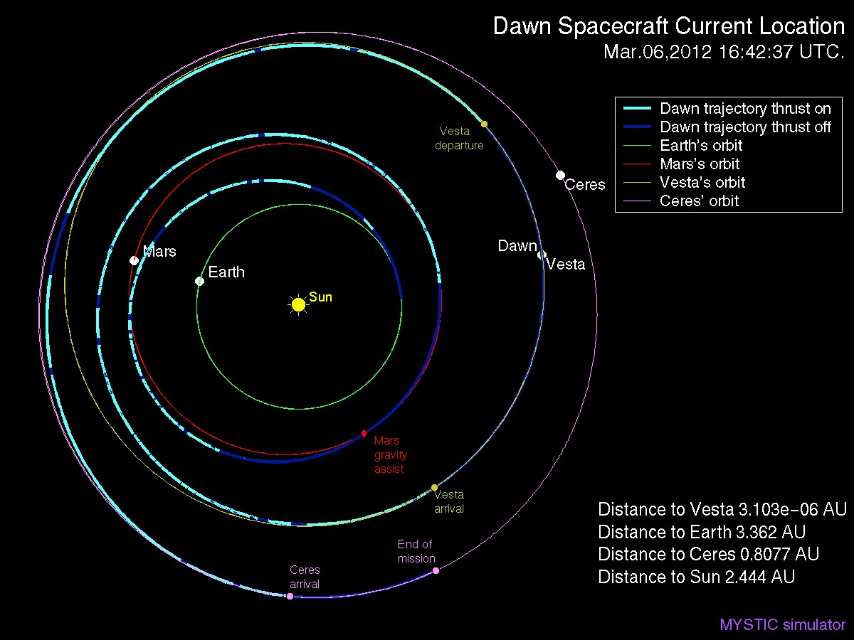
Dawn Spacecraft Current Location and Trajectory - March, 6 2012. Credit: Gregory J. Whiffen, JPL
“We always carried 40 days of “margin,” said Rayman, “but no one who was knowledgeable about the myriad challenges of exploring this uncharted world expected we would be able to accomplish all the complicated activities before LAMO without needing to consume some of that margin. So although we recognized that we might get to spend some additional time in LAMO, we certainly did not anticipate it would be so much.”
“As it turned out, although we did have surprises the operations team managed to recover from all of them without using any of those 40 days.”
“This is a wonderful bonus for science,” Rayman concluded.
“We remain on schedule to depart Vesta in July 2012, as planned for the past several years.”
Dawn’s next target is Ceres, the largest asteroid in the main Asteroid Belt between Mars and Jupiter
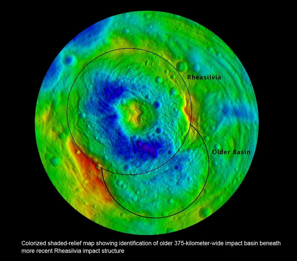
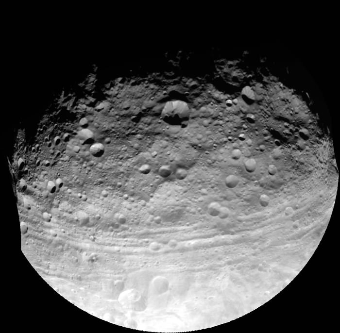
Southern Hemisphere of Vesta; Rheasilvia and Older Basin. Colorized shaded-relief map showing identification of older 375-kilometer-wide impact basin beneath and overlapping with the more recent Rheasilvia impact structure at asteroid Vesta’s South Pole. Credit: NASA/JPL-Caltech/UCLA/MPS/DLR/IDA
[/caption]
Scientists leading NASA’sDawn mission have discovered a 2nd giant impact basin at the south pole of the giant asteroid Vesta, which has been unveiled as a surprisingly “dichotomous” and alien world. Furthermore, the cosmic collisions that produced these two basins shuddered through the interior and created vast Vestan troughs, a Dawn scientist told Universe Today.
The newly discovered impact basin, nicknamed ‘Older Basin’, is actually significantly older in age compared to the initially discovered South Pole basin feature named ‘Rheasilvia’ – perhaps by more than a billion years. And that is just one of the many unexplained mysteries yet to be reconciled by the team as they begin to sift through the millions of bits of new data streaming back daily to Earth.
Scientists speculate that ‘Older Basin’ is on the order of 3.8 Billion years old, whereas ‘Rheasilvia’ might be as young as about 2.5 Billion years, but those are just tentative estimates at this time and subject to change. Measurements so far indicate Rheasilvia is composed of basaltic material.
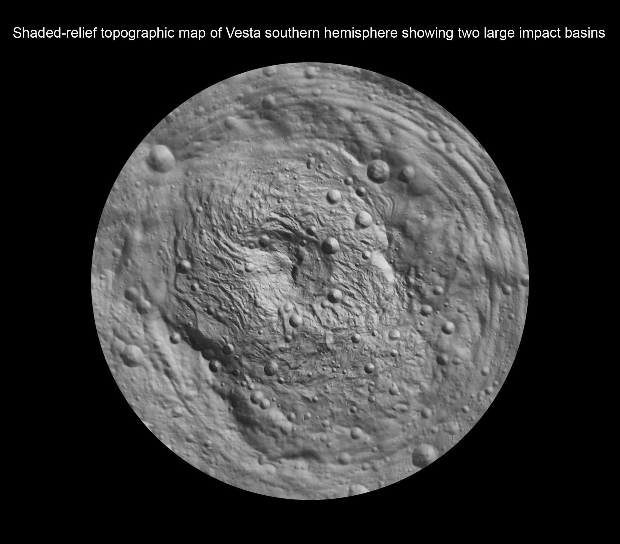
Shaded-relief topographic map of Vesta southern hemisphere showing two large impact basins - Rheasilvia and Older Basin.
Credit: NASA/JPL-Caltech/UCLA/MPS/DLR/IDA
“We found many surprising things at Vesta, which is quite unique and the results have exceeded our expectations”, said Dr. Carol Raymond, Dawn deputy principal investigator, of NASA’s Jet Propulsion Laboratory, Pasadena, Calif.
Researchers presented the latest findings from Dawn’s initial science mapping orbit at a news briefing at the annual meeting of the Geological Society of America in Minneapolis, Minn., on Oct. 13.
The team considers Vesta to be the smallest terrestrial planet.
Since achieving orbit in July, Dawn’s Framing Cameras (FC) have imaged most of Vesta at about 250 meter resolution and the Visible and Infrared mapping spectrometer(VIR) at about 700 meter resolution. The measurements were collected at the survey orbit altitude of 2700 km. Before Dawn, Vesta was just a fuzzy blob in humankind’s most powerful telescopes.
Vesta from Hubble (top) as a fuzzy blob and from Dawn in orbit (bottom) in crystal clear high resolution.
Credit: NASA/JPL-Caltech/ UCLA/MPS/DLR/IDA
“There is a global dichotomy on Vesta and a fundamental difference between the northern and southern hemispheres”, said Raymond. “The northern hemisphere is older and heavily cratered in contrast to the brighter southern hemisphere where the texture is more smooth and there are lots of sets of grooves. There is a massive mountain at the South Pole. One of the more surprising aspects is the set of deep equatorial troughs.”
“There is also a tremendous and surprising diversity of surface color and morphology. The south is consistent with basaltic lithology and the north with impacts. We are trying to make sense of the data and will integrate that with the high resolution observations we are now collecting.”
Indeed Vesta’s completely unique and striking dichotomy can be directly traced back to the basins which were formed by ancient cataclysmic impacts resulting in shockwaves that fundamentally altered the surface and caused the formation of the long troughs that ring Vesta at numerous latitudes.
“The troughs extend across 240 degrees of longitude,” said Debra Buczkowski, Dawn participating scientist, of the Applied Physics Laboratory at Johns Hopkins University, Laurel, Md. “Their formation can be tied back to the two basins at the South Pole.”
Asteroid Vesta and Equatorial Grooves
This full view of the giant asteroid Vesta was taken by NASA’s Dawn spacecraft, as part of a rotation characterization sequence on July 24, 2011, at a distance of 3,200 miles (5,200 kilometers). A rotation characterization sequence helps the scientists and engineers by giving an initial overview of the character of the surface as Vesta rotated underneath the spacecraft. This view of Vesta shows impact craters of various sizes and grooves parallel to the equator. The resolution of this image is about 500 meters per pixel. Credit: NASA/JPL-Caltech/UCLA/MPS/DLR/IDA
In an exclusive follow up interview with Universe Today, Raymond said “We believe that the troughs formed as a direct result of the impacts,” said “The two sets of troughs are associated with the two large basins [Rheasilvia and Older Basin].”
“The key piece of evidence presented was that the set of troughs in the northern hemisphere, that look older (more degraded) are circumferential to the older impact basin,” Raymond told me.
“The equatorial set are circumferential to Rheasilvia. That Rheasilvia’s age appears in places to be much younger is at odds with the age of the equatorial troughs. An explanation for that could be resurfacing by younger mass wasting features (landslides, slumps). We will be working on clarifying all these relationships in the coming months with the higher resolution HAMO (High Altitude Mapping Orbit) data.”
Dawn has gradually spiraled down closer to Vesta using her exotic ion thrusters and began the HAMO mapping campaign on Sept. 29.
Surface features are dated by crater counting methodology.
“Preliminary crater counting age dates for the equatorial trough region yields a very old age (3.8 Billion years). So there is a discrepancy between the apparent younger age for the Rheasilvia basin and the old age for the troughs. These could be reconciled if Rheasilvia is also 3.8 Billion years old but the surface has been modified by slumping or other processes,” Raymond elaborated.
Time will tell as further data is analyzed.
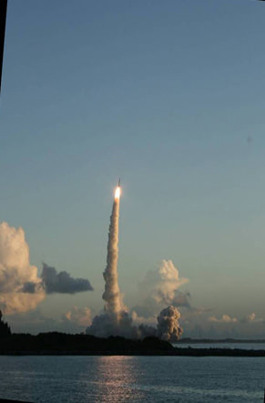
Dawn launch on September 27, 2007 by a Delta II Heavy rocket from Cape Canaveral Air Force Station, Florida. Credit: Ken Kremer
“Vesta is full of surprises, no more so than at the South Pole,” said Paul Schenk at the GSA briefing. Schenk is a Dawn participating scientist of the Lunar and Planetary Institute, Houston, Texas.
The ‘Rheasilvia’ basin was initially discovered in images of Vesta taken a decade ago by the Hubble Space Telescope which revealed it as a gaping hole in the southern hemisphere. But it wasn’t until Dawn entered orbit on July 16, 2011 after a nearly four year interplanetary journey that Earthlings got their first close up look at the mysterious polar feature and can now scrutinize it in detail to elucidate its true nature.
“The South Pole [Rheasilvia] basin is a roughly circular, impact structure and a deep depression dominated by a large central mound,” said Schenk. “It shows sharp scarps, smooth areas, landslide deposits, debris flows. It’s about 475 km in diameter and one of the deepest (ca. 20 -25 km) impact craters in the solar system.”
The central peak is an enormous mountain, about 22 km high and 180 km across- one of the biggest in the solar system. “It’s comparable in some ways to Olympus Mons on Mars,” Schenk stated.
“We were quite surprised to see a second basin in the mapping data outside of Rheasilvia. This was unexpected. It’s called ‘Older Basin’ for now.”
‘Older Basin’ is about 375 km in diameter. They overlap at the place where Rheasilvia has a missing rim.
“These basins are interesting because we believe Vesta is the source of a large number of meteorites, the HED meteorites that have a spread of ages,” Schenk explained.
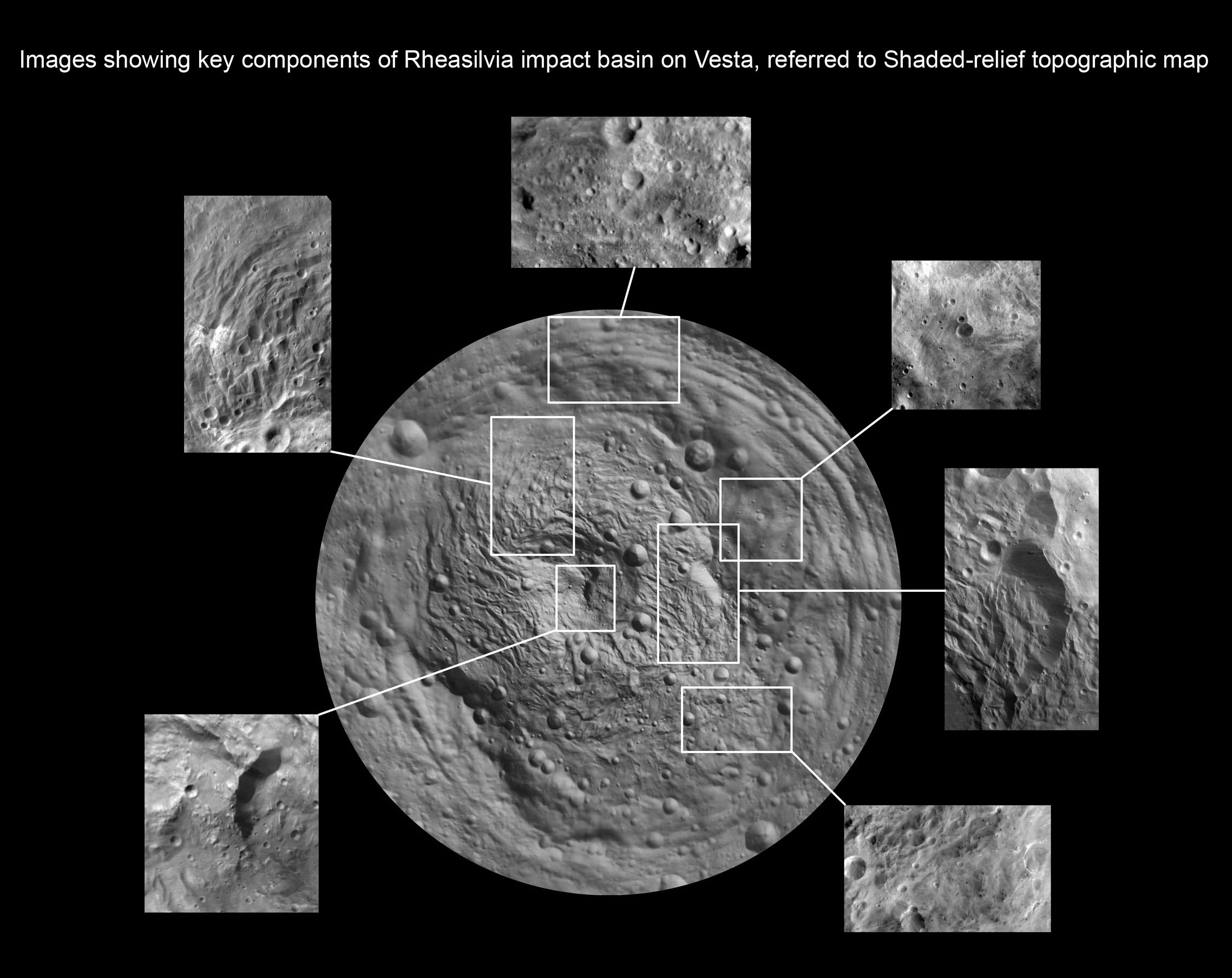
Images showing key components of Rheasilvia impact basin on Vesta in high resolution ,referred to Shaded-relief topographic map. Credit: NASA/JPL-Caltech/ UCLA/MPS/DLR/IDA
Multiple large impacts over time may explain the source of the HED (Howardite, Eucrite and Diogenite) meteorites.
“We did expect large impacts on Vesta, likely associated with the late heavy bombardment recognized in the lunar impact record,” Raymond told Universe Today. “The surprising element is that the two apparently largest impacts – keeping in mind that other larger impact basins may be lurking under the regolith – are overlapping.”
Dawn’s VIR spectrometer has detected pyroxene bands covering Vesta’s surface, which is indicative of typical basaltic material, said Federico Tosi, a VIR team member of the Italian Space Agency, Rome. “Vesta has diverse rock types on its surface.”
“VIR measured surface temperatures from 220K to 270 K at the 5 micron wavelength. The illuminated areas are warmer.”
So far there is no clear indication of olivine which would be a marker for seeing Vesta’s mantle, Tossi elaborated.
The VIR spectrometer combines images, spectral information and temperature that will allow researchers to evaluate the nature, composition and evolutionary forces that shaped Vesta’s surface.
The team is absolutely thrilled to see a complicated geologic record that’s been preserved for study with lots of apparent surface layering and surprisingly strong and complex structural features with a large range of color and brightness.
Stay tuned for a year of Vestan delights !
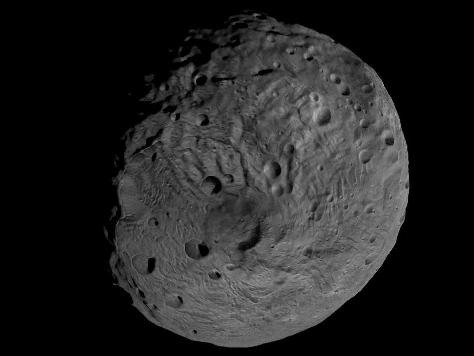
Asteroid Vesta from Dawn
South Pole Rheasilvia basin is at lower right. NASA's Dawn spacecraft obtained this image of the giant asteroid Vesta with its framing camera on July 24, 2011 from a distance of about 3,200 miles (5,200 kilometers). Dawn entered orbit around Vesta on July 16, and will spend a year orbiting the body.
Credit: NASA/JPL-Caltech/UCLA/MPS/DLR/IDA
Viewing the South Pole of Vesta. This image obtained by Dawns framing camera and shows the south pole of the giant asteroid Vesta. Scientists are discussing whether the circular structure that covers most of this image originated by a collision with another asteroid, or by internal processes early in the asteroid's history. Images in higher resolution from Dawn's lowered orbit might help answer that question. The image was recorded from a distance of about 1,700 miles (2,700 kilometers). The image resolution is about 260 meters per pixel. Credit: NASA/JPL-Caltech/UCLA/MPS/DLR/IDA
Take us into orbit Mr. Sulu!
The Dawn science team has released two spectacular rotation movies of the entire globe of the giant asteroid Vesta. The flyover videos give the distinct impression that you are standing on the bridge of the Starship Enterprise and gazing at the view screen as the ship enters orbit about a new planet for the first time and are about to begin an exciting new journey of exploration and discovery of the body you’re looking at below.
Thanks to NASA, DLR, ASI and Dawn’s international science and engineering team, we can all join the away team on the expedition to unveil Vesta’s alluring secrets.
Click the start button and watch protoplanet Vesta’s striking surface moving beneath from the perspective of Dawn flying above – in the initial survey orbit at an altitude of 2700 kilometers (1700 miles). Vesta is the second most massive object in the main asteroid belt and Dawn’s first scientific conquest.
Another video below was compiled from images taken earlier on July 24, 2011 from a higher altitude after Dawn first achieved orbit about Vesta and revealed that the northern and southern hemispheres are totally different.
The array of images in the videos was snapped by Dawn’s framing camera which was provided by the German Aerospace Center (DLR). The team then created a shape model from the images, according to Dr. Carol Raymond, Dawn’s Deputy Principal Investigator from NASA’s Jet Propulsion Laboratory in Pasadena, Calif.
The shape model will aid in studying Vesta’s strikingly diverse features of mountains, ridges, valley’s, scarps, cliffs, grooves, craters, even a ‘snowman’ and much more.
Notice that not all of Vesta is illuminated – because it’s northern winter at the asteroid. Vesta has seasons like Earth and the northern polar region in now in perpetual darkness. Data is collected over the day side and radioed back to Earth over the night side.
“On Vesta right now, the southern hemisphere is facing the sun, so everywhere between about 52 degrees north latitude and the north pole is in a long night,” says Dr. Rayman, Dawn’s Chief Engineer from JPL. “That ten percent of the surface is presently impossible to see. Because Dawn will stay in orbit around Vesta as together they travel around the sun, in 2012 it will be able to see some of this hidden scenery as the seasons advance.”
Another movie highlight is a thorough look at the gigantic south pole impact basin. The circular feature is several hundred miles wide and may have been created by a cosmic collision eons ago that excavated massive quantities of material and basically left Vesta lacking a south pole.
[/caption]
The massive feature was discovered in images taken by the Hubble Space Telescope several years ago and mission scientists have been eager to study it up close in a way that’s only possible from orbit. Dawn’s three science instruments will investigate the south pole depression in detail by collecting high resolution images and spectra which may reveal the interior composition of Vesta.
Dawn entered the survey orbit on Aug. 11 and completed seven revolutions of 69 hours each on Sept. 1. It transmitted more than 2,800 pictures from the DLR framing camera covering the entire illuminated surface and also collected over three million visible and infrared spectra from the VIR spectrometer – provided by ASI, the Italian Space Agency. This results exceeded the mission objectives.
The Dawn spacecraft is now spiraling down closer using its ion propulsion system to the next mapping orbit – known as HAMO – four times closer than the survey orbit and only some 680 km (420 miles) above the surface.