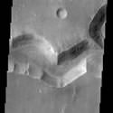
Chinese Dust Disaster Imaged From Space

Image credit: NASA

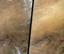
NASA’s Terra Earth Observing Satellite was on hand this week to record some of the worst dust storms to hit China’s Inner Mongolian and Shanxi Provinces in ten years. The photo on the left shows a relatively clear day, while the one on the right is obscured by a yellowish cloud of dust. Each image was captured by the spacecraft’s Multi-angle Imaging SpectroRadiometer, and represents an area of 380 km x 630 km.

Dust covered northern China earlier this week during some of the worst dust storms to hit the region in a decade. The dust obscuring China’s Inner Mongolian and Shanxi Provinces on March 24 is compared with a relatively clear day (October 31, 2001) in these images from the Multi-angle Imaging SpectroRadiometer’s vertical-viewing (nadir) camera aboard NASA’s Terra Earth Observing Spacecraft. Each image represents an area of about 380 by 630 kilometers (236 by 391 miles).

The images are available at:

http://www.jpl.nasa.gov/images/earth/asia.

In the image from late March, shown on the right, wave patterns in the yellowish cloud liken the storm to an airborne ocean of dust. The veil of particulates obscures features on the surface north of the Yellow River (visible in the lower left). The area shown lies near the edge of the Gobi desert, a few hundred kilometers, or miles, west of Beijing. Dust originates from the desert and travels east across northern China toward the Pacific Ocean. For especially severe storms, fine particles can travel as far as North America.

The Multi-angle Imaging SpectroRadiometer, built and managed by NASA’s Jet Propulsion Laboratory, Pasadena, Calif., is one of five Earth-observing experiments aboard the Terra satellite, launched in December 1999. The instrument acquires images of Earth at nine angles simultaneously, using nine separate cameras pointed forward, downward and backward along its flight path. The change in reflection at different view angles affords the means to distinguish different types of atmospheric particles, cloud forms and land surface covers. More information is available at:

http://www-misr.jpl.nasa.gov.

NASA’s Earth Science Enterprise is a long-term research and technology program designed to examine Earth’s land, oceans, atmosphere, ice and life as a total integrated system.

JPL is a division of the California Institute of Technology in Pasadena.

Original Source: NASA News Release

Envisat Begins Study of Earth’s Environment

The European Space Agency’s recently-launched Envisat began its ten year mission last week to gauge the health of planet Earth. The $2.2 billion, 9 ton satellite successfully turned on all ten of its scientific instruments and took some high-quality images of the break-up of the Larson B ice shelf in Antarctica. Another instrument captured images of photosynthetic plankton near the coast of Mauritania in northwest Africa.

Chinese Capsule Lands

China’s third unmanned spacecraft returned to Earth on Monday after spending a week in orbit. The Shenzhou capsule, touched down in northern China’s Inner Mongolia Autonomous Region at 0851 GMT (3:51am EST). The spacecraft contained a series of experiments designed to test the life support systems of the capsule. It’s still unknown when China will actually send humans into space, but officials from the country’s space agency said that more unmanned tests will still be required.

Secretive Atlantis Countdown Starts

NASA began the countdown for Thursday’s launch of the space shuttle Atlantis; however, the specific launch time is still being kept confidential until 24 hours before – some time between 1900-2300 GMT (2:00pm-6:00pm EST). When Atlantis does launch, it will fly up to dock with the International Space Station and its 7-astronaut crew will attach a $600 million truss and $190 million rail car and track which will enable the station’s robot arm to move from end to end assisting construction. (NASA Status Report)

Odyssey Serves Up Canyon Images

Image credit: NASA

Now in its final orbit, Mars Odyssey is getting to work searching for water on the surface of the planet. The most recent set of images returned are of a network of channels taken by the Thermal Emission Imaging System (THEMIS). The Nirgal Vallis is a channel 500 km long and 6 km wide at this point – astronomers believe that gullies on the side of the channel were formed when water erupted to the surface.

This THEMIS image shows a sinuous valley network channel with sharp bends cutting across the cratered highlands of the southern hemisphere of Mars. The channel is named Nirgal Vallis, which is from the Babylonian word for “Mars”. Nirgal Vallis is a channel with a total length of approximately 500 km. It is approximately 6 km wide in this region. Gullies and alluvial deposits discovered by Mars Global Surveyor are clearly visible on the polar-facing (south) wall and floor of Nirgal Vallis. These gullies appear to emanate from a specific layer in the walls. There is a pronounced sparsity of gullies on the equator-ward facing slopes. The gullies have been proposed to have formed by the subsurface release of water. Patches of dunes are also seen on the channel floor, notably along the edges of the channel floor near the canyon walls. There is still debate within the scientific community as to how valley networks themselves form: surface runoff (rainfall/snowmelt) or headward erosion via groundwater sapping. This image is approximately 22 km wide and 60 km in length; north is toward the top.

Original Source: ASU News Release

Gemini Builds Animation of Galactic Core

Image credit: Gemini

The Gemini Observatory located on top of Hawaii’s Mauna Kea has been used to create an animation of the action going on in galaxy NGC 1068. Using a tool called the Integral Field Unit, astronomers have been able to create a 3-dimensional animation of the tremendous jet emanating from the supermassive black hole as it slams into the galactic gas disk.

Astronomers observing with the Gemini North Telescope on Hawaii’s Mauna Kea have a powerful new tool to probe mysterious cosmic caldrons like those at the cores of galaxies and stellar nurseries.

Using the recently commissioned Integral Field Unit (IFU) on the Gemini Multi-Object Spectrograph (GMOS), astronomers at the observatory have recently obtained a complete multi-dimensional picture of the dynamic flow of gas and stars at the core of an active galaxy named NGC 1068 in a single snap-shot. The resulting windfall of data has been transformed into an animation that dramatically reveals the internal gyrations of the galaxy – including the interactions of a pair of galactic-scale jets that spew material for thousands of light years away from the suspected black hole at the galaxy’s core.

“The Gemini data of NGC 1068 reveal one of the lesser know features of galaxy jets,” explains Gemini North Associate Director Dr. Jean-Ren? Roy. “For the first time we were able to clearly see the jet’s expanding lobe as its hypersonic bow shock slams directly into the underlying gas disk of the galaxy. It’s like a huge wave smashing onto a galactic shoreline.”

Dr. Gerald Cecil of the University of North Carolina, recently led an international team to study this particular galaxy using spectra taken with the Hubble Space Telescope and believes that the new Gemini spectra will clarify many patterns revealed by Hubble. “Large ground-based telescopes like Gemini are the perfect complement to Hubble because they can collect so much more light. But it’s critical to use all this light cunningly, and not throw most of it away as standard slit spectrographs do. The GMOS’s integral field capability now enables detailed studies of fundamental physical processes that were previously too time consuming to conduct on faint cosmic sources.” The Hubble findings by Dr. Cecil et al. will appear in the April 1, 2002 issue of the Astrophysical Journal.

“By using Integral Field Spectroscopy we add dimensions to the data and can essentially make a movie with one click of the shutter,” says Dr. Bryan Miller, the Gemini instrument scientist for IFUs. “When we play back our movie of the galaxy NGC1068, we see a 3-dimensional view of the core of this galaxy. It is striking how much easier it is to interpret features with this kind of data. With integral-field data we can determine the mass distributions, the true shapes, and the histories of galaxies more accurately than before.” The Integral Field Spectroscopy findings by Dr. Miller et al. will appear in the Conference Series of the Astronomical Society of the Pacific.

This technology is new to the world of 8-10 meter class telescopes and is especially powerful on new generation telescopes like Gemini that use the latest optical technologies to focus starlight to razor sharpness. “We are very excited by these results and the superb capabilities that the integral field unit has given the GMOS in Hawaii”, notes Dr. Jeremy Allington-Smith, the scientist from the University of Durham in the United Kingdom who managed the construction of the GMOS Integral Field Unit. “In effect we have added an extra dimension to the instrument so that it can map the motion of gas and stars at any point in the image of the object under study. The GMOS IFU will be a powerful new tool for studying the centers of active galaxies that may harbor black holes, as well as the dynamic internal motions of galaxies and star forming regions.” The GMOS IFU findings by Dr. Allington-Smith et al. will appear in the Conference Series of the Astronomical Society of the Pacific.

An Integral Field Unit (IFU) like the one used in the GMOS uses hundreds of tiny optical fibers (each thinner than an human hair) with tiny micro-lenses attached to guide light from the telescope’s 2-D image to a spectrograph. The spectrograph produces one individual spectrum for each fiber for a total of 1500 individual spectra that can each reveal details of the physical conditions and velocity of the gas, dust and stars it studies. This system was the first IFU to be installed on the new generation of 8 and 10m telescopes when it was commissioned on the Gemini-North telescope in 2001.

The Integral Field Spectroscopy capabilities of the Gemini Observatory are still developing. Within the next two years both telescopes will have optical and near-infrared integral field units. Some of these systems will work with adaptive optics to provide the highest spatial resolution images deliverable by the telescopes, including images in the infrared that will be sharper than can be produced by the Hubble Space Telescope at those wavelengths.

The Gemini Observatory is an international collaboration that has built two identical 8-meter telescopes. The telescopes are located at Mauna Kea, Hawaii (Gemini North) and Cerro Pach?n in central Chile (Gemini South), and hence provide full coverage of both hemispheres of the sky. Both telescopes incorporate new technologies that allow large, relatively thin mirrors under active control to collect and focus both optical and infrared radiation from space. Gemini North began science operations in 2000 and Gemini South began scientific operations in late 2001.

The Gemini Observatory provides the astronomical communities in each partner country with state-of-the-art astronomical facilities that allocate observing time in proportion to each country’s contribution. In addition to financial support, each country also contributes significant scientific and technical resources. The national research agencies that form the Gemini partnership include: the US National Science Foundation (NSF), the UK Particle Physics and Astronomy Research Council (PPARC), the Canadian National Research Council (NRC), the Chilean Comisi?n Nacional de Investigaci?n Cientifica y Tecnol?gica (CONICYT), the Australian Research Council (ARC), the Argentinean Consejo Nacional de Investigaciones Cient?ficas y T?cnicas (CONICET) and the Brazilian Conselho Nacional de Desenvolvimento Cient?fico e Tecnol?gico (CNPq). The Observatory is managed by the Association of Universities for Research in Astronomy, Inc. (AURA) under a cooperative agreement with the NSF. The NSF also serves as the executive agency for the international partnership.

Original Source: Gemini News Release

NASA Showcases its Airbag System

Image credit: NASA

It was a bit of a rough ride, but Pathfinder arrived on the surface of Mars back in 1997 in perfect condition. It was the innovative (and unproven) airbag system that helped slow the lander’s descent, so NASA is planning to employ the system again for the 2003 Mars Exploration Rover missions. These rovers have a different mass than Pathfinder, so NASA engineers have gone back to the drawing board to figure out how to make airbags that inflate seconds before touchdown and can withstand an impact at freeway speeds.

Just one of the many problems in landing on another planet, after it’s been determined where to land and the method to get there, is landing safely. For JPL, a safe landing is “the name of the game,” as engineers work to prepare two rovers for the journey to Mars.

The Mars Exploration Rovers scheduled for launch in 2003 are using the same type airbag landing system that Mars Pathfinder used in 1997. The airbags must be strong enough to cushion the spacecraft if it lands on rocks or rough terrain and allow it to bounce across Mars’ surface at freeway speeds after landing. To add to the complexity, the airbags must be inflated seconds before touchdown and deflated once safely on the ground.

“The 2003 rovers have a different mass [than Sojourner, the Pathfinder rover], so we’ve made changes in the airbag design,” said John Carson, cognizant engineer. “Our requirement is to be able to land safely on a rock extending about a half-meter (about 18 inches) above the surface. Extensive testing gives us a process for trial and error before the final design.”

How to Build a Better Airbag
While most new automobiles now come with airbags, spacecraft don’t. The fabric being used for the new Mars airbags is a synthetic material called Vectran that was also used on Mars Pathfinder. Vectran has almost twice the strength of other synthetic materials, such as Kevlar, and performs better at cold temperatures.

Denier is a term that measures the diameter of the thread used in the product. There will be six 100-denier layers of the light but tough Vectran protecting one or two inner bladders of the same material in 200-denier, according to Dara Sabahi, mechanical systems architect. Using the 100-denier means there is more actual fabric in the outer layers where it is needed, because there are more threads in the weave.

Each rover uses four airbags with six lobes each, which are all connected. Connection is important, since it helps abate some of the landing forces by keeping the bag system flexible and responsive to ground pressure. The fabric of the airbags is not attached directly to the rover; ropes that crisscross the bags hold the fabric to the rover. The ropes give the bags shape, which makes inflation easier. While in flight, the bags are stowed along with three gas generators that are used for inflation.

Testing, Testing, Testing
Since the airbags are composed of many layers, some tearing in the outer layers is acceptable and even expected. Engineers test the bags to make sure there will be no catastrophic problems that would prevent a safe landing.

Mars airbag testing is done in world’s largest vacuum chamber at the Plum Brook Station of NASA’s Glenn Research Center in Ohio. “The Plum Brook facility is pretty impressive, along with all the people who operate it,” said Carson.

The test chamber used for the tests is a little over 30 meters (100 feet) across and about 37 meters (120 feet) high — big enough that three railroad tracks go through it. A test spacecraft and airbag system weighing about 535 kilograms (about 1,180 pounds) are accelerated with a bungee cord system onto a platform with rocks that approximate the Mars surface. The drop is at landing speed, about 20 to 24 meters (yards) per second.

Tests are documented thoroughly with high-speed and video cameras, in addition to visual inspections. Engineers even built a clear dome, studded with rocks, that has a camera that documents tests from a rock’s-eye view. During testing, a crew from ILC Dover, the airbag’s manufacturer, stands by to make quick repairs and to note any changes required.

“We do extensive testing,” said Tom Rivellini, deputy mechanical systems architect. “We want to break the bag on Earth, not on Mars. If we see a tear that is unexpected or goes too deep, we can make changes now [before the final design].”

Carson added, “We’ll go over all the data we’ve accumulated so far, do some more testing, and decide on a design configuration.”

And then on to Mars in 2003!

Galileo Navigation System is a Go

European transport ministers have approved a plan to develop Galileo, a satellite navigation system. Galileo, which is due to come online in 2008, is expected to cost $3.15 billion US and will consist of 30 satellites deployed in three circular Medium Earth Orbits at an altitude of 23,616 km. Although the system will compete with the US-built Global Positioning System, the designers say the two networks will be compatible and provide redundancy.

Hubble Reveals Blue Galaxy Ablaze with Star Formation

A new photo released from the Hubble Space Telescope shows how galaxy NGC 7673 is teeming with hot star nurseries. Located 150 million light years away in the constellation of Pegasus, each cluster in this new photograph contains thousands of infant stars burning at incredibly high temperatures. Astronomers aren’t sure why this galaxy is so active, but it could be because the galaxy collided with another millions of years ago.

NASA Classifies Shuttle Launch Times

NASA officials have decided to keep the exact time of launch of the next space shuttle a secret until 24 hours before liftoff to guard against terrorist attack. So, the launch of the space shuttle Atlantis, on a mission to continue assembly of the International Space Station, will occur at some point on the afternoon of April 4th.