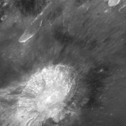
Image credit: Andrzej Baran. Click to enlarge.

Space and astronomy news
Image credit: Andrzej Baran. Click to enlarge.
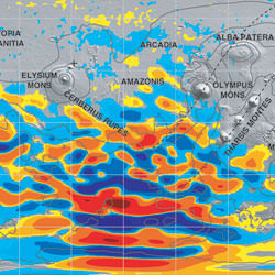
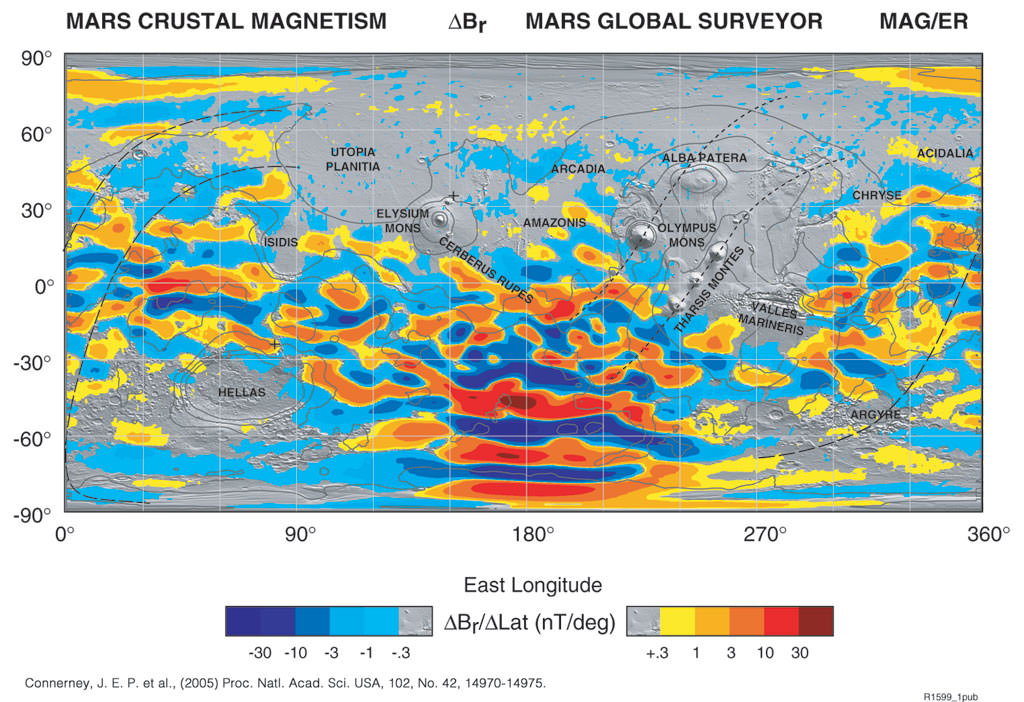
Crustal magnetism readings across Mars. Image credit: NASA/JPL. Click to enlarge.
NASA scientists have discovered additional evidence that Mars once underwent plate tectonics, slow movement of the planet’s crust, like the present-day Earth. A new map of Mars’ magnetic field made by the Mars Global Surveyor spacecraft reveals a world whose history was shaped by great crustal plates being pulled apart or smashed together.
Scientists first found evidence of plate tectonics on Mars in 1999. Those initial observations, also done with the Mars Global Surveyor’s magnetometer, covered only one region in the Southern Hemisphere. The data was taken while the spacecraft performed an aerobraking maneuver, and so came from differing heights above the crust.
This high resolution magnetic field map, the first of its kind, covers the entire surface of Mars. The new map is based on four years of data taken in a constant orbit. Each region on the surface has been sampled many times. “The more measurements we obtain, the more accuracy, and spatial resolution, we achieve,” said Dr. Jack Connerney, co-investigator for the Mars Global Surveyor magnetic filed investigation at NASA’s Goddard Space Flight Center, Greenbelt, Md.
“This map lends support to and expands on the 1999 results,” said Dr. Norman Ness of the Bartol Research Institute at the University of Delaware, Newark. “Where the earlier data showed a “striping” of the magnetic field in one region, the new map finds striping elsewhere. More importantly, the new map shows evidence of features, transform faults, that are a “tell-tale” of plate tectonics on Earth.” Each stripe represents a magnetic field pointed in one directionpositive or negativeand the alternating stripes indicate a “flipping” of the direction of the magnetic field from one stripe to another.
Scientists see similar stripes in the crustal magnetic field on Earth. Stripes form whenever two plates are being pushed apart by molten rock coming up from the mantle, such as along the Mid-Atlantic Ridge. As the plate spreads and cools, it becomes magnetized in the direction of the Earth’s strong global field. Since Earth’s global field changes direction a few times every million years, on average, a flow that cools in one period will be magnetized in a different direction than a later flow. As the new crust is pushed out and away from the ridge, stripes of alternating magnetic fields aligned with the ridge axis develop. Transform faults, identified by “shifts” in the magnetic pattern, occur only in association with spreading centers.
To see this characteristic magnetic imprint on Mars indicates that it, too, had regions where new crust came up from the mantle and spread out across the surface. And when you have new crust coming up, you need old crust plunging back downthe exact mechanism for plate tectonics.
Connerney points out that plate tectonics provides a unifying framework to explain several Martian features. First, there is the magnetic pattern itself. Second, the Tharsis volcanoes lie along a straight line. These formations could have formed from the motion of a crustal plate over a fixed “hotspot” in the mantle below, just as the Hawaiian islands on Earth are thought to have formed. Third, the Valles Marineris, a large canyon six times as long as the Grand Canyon and eight times as deep, looks just like a rift formed on Earth by a plate being pulled apart. Even more, it is oriented just as one would expect from plate motions implied by the magnetic map.
“It’s certainly not an exhaustive geologic analysis,” said Dr. Mario Acuña, principal investigator for the Mars Global Surveyor magnetic filed investigation at Goddard Space Flight Center. “But plate tectonics does give us a consistent explanation of some of the most prominent features on Mars.”
Results were published in the Oct. 10 edition of the Proceedings of the National Academy of Science.
Other scientists working on the project included Dr. G. Kletetschka of the Catholic University of America, Washington, DC, and Goddard Space Flight Center; Dr. D.L. Mitchell and Dr. R.P. Lin of the University of California at Berkeley; and Dr. H. Reme of the Centre d’Etude Spatiale des Rayonnements in France. Dr. Acuña leads the international team that built and operates the Mars Global Surveyor magnetometers. The Jet Propulsion Laboratory, a division of the California Institute of Technology in Pasadena, manages the mission for NASA’s Science Mission Directorate in Washington.
Original Source: NASA News Release

Artist illustration of microscopic crystals surrounding a dusty disk. Image credit: NASA/JPL. Click to enlarge.
NASA’s Spitzer Space Telescope has spotted the very beginnings of what might become planets around the puniest of celestial orbs – brown dwarfs, or “failed stars.”
The telescope’s infrared eyes have for the first time detected clumps of microscopic dust grains and tiny crystals orbiting five brown dwarfs. These clumps and crystals are thought to collide and further lump together to eventually make planets. Similar materials are seen in planet-forming regions around stars and in comets, the remnants of our own solar system’s construction.
The findings provide evidence that brown dwarfs, despite being colder and dimmer than stars, undergo the same initial steps of the planet-building process.
“We are learning that the first stages of planet formation are more robust than previously believed,” said Dr. Daniel Apai, an astronomer at the University of Arizona, Tucson, and member of the NASA Astrobiology Institute’s Life and Planets Astrobiology Center. “Spitzer has given us the possibility to study how planets are built in widely different environments.”
The observations also imply that brown dwarfs might be good targets for future planet-hunting missions. Astronomers do not know if life could exist on planets around brown dwarfs.
Brown dwarfs differ from stars largely due to their mass. They lack the mass to ignite internally and shine brightly. However, they are believed to arise like stars, out of thick clouds of gas and dust that collapse under their own weight. And like stars, brown dwarfs develop disks of gas and dust that circle around them. Spitzer has observed many of these disks, which glow at infrared wavelengths.
Apai and his team used Spitzer to collect detailed information on the minerals that make up the dust disks of six young brown dwarfs located 520 light-years away, in the Chamaeleon constellation. The six objects range in mass from about 40 to 70 times that of Jupiter, and they are roughly 1 to 3 million years old.
The astronomers discovered that five of the six disks contain dust particles that have crystallized and are sticking together in what may be the early phases of planet assembling. They found relatively large grains and many small crystals of a mineral called olivine.
“We are seeing processed particles that are linking up and growing in size,” said Dr. Ilaria Pascucci, a co-author also of the University of Arizona. “This is exciting because we weren’t sure if the disks of such cool objects would behave the same way that stellar disks do.”
The team also noticed a flattening of the brown dwarfs’ disks, which is another sign that dust is gathering up into planets.
A paper on these findings appears online today in Science. Authors of the paper also include Drs. Jeroen Bouwman, Thomas Henning and Cornelis P. Dullemond of the Max Planck Institute for Astronomy, Germany; and Dr. Antonella Natta of the Osservatorio Astrofisico di Arcetri, Italy.
NASA’s Jet Propulsion Laboratory, Pasadena, Calif., manages the Spitzer mission for NASA’s Science Mission Directorate. Science operations are conducted at the Spitzer Science Center at the California Institute of Technology in Pasadena. Spitzer’s infrared spectrograph, which made the observations, was built by Cornell University, Ithaca, N.Y. Its development was led by Dr. Jim Houck of Cornell. The NASA Astrobiology Institute, founded in 1997, is a partnership between NASA, 16 major U.S. teams and six international consortia.
For artist concepts, graphics and more information about Spitzer, visit http://www.spitzer.caltech.edu/spitzer/ . For more information about the NASA Astrobiology Institute, visit http://nai.arc.nasa.gov/ . For more information about NASA and agency programs on the Web, visit http://www.nasa.gov/home/ .
Original Source: NASA/JPL News Release
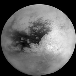
Saturn’s Moon Titan. Image credit: NASA/JPL/SSI. Click to enlarge.
University of Arizona scientists say that the peculiar clouds at middle latitudes in Titan’s southern hemisphere may form in the same way as distinct bands of clouds form at Earth’s equator.
“Titan’s weather is very different from Earth’s,” said UA associate professor Caitlin Griffith. “If you walked past Titan’s minus-40-degree-latitude line, you might be showered with liquid natural gas. If you decided to visit Titan’s south pole, you might encounter a storm the size of a hurricane which also consists of methane, more commonly known as natural gas,” Griffith said. “Otherwise, don’t expect clouds on Titan.”
Titan’s weather forecast has remained the same for years, and that baffles scientists. They don’t understand why clouds a thousand miles long stretch over the temperate latitude.
“Imagine how curious it would be if beyond Earth’s poles, clouds existed only at the latitude that crosses New Zealand, Argentina and Chile,” Griffith said. “Furthermore, Henry Roe (of the California Institute of Technology) and his colleagues find that most of these peculiar clouds bunch up at zero degrees and 90 degrees longitude, analogous to Earth longitudes southwest and southeast of the Cape of Good Hope,” she added.
The highly localized nature of the clouds suggests that they have something to do with Titan’s surface, Griffith said. Scientists think ice volcanoes must be venting methane — the gas that condenses as clouds — into Titan’s hazy, mostly nitrogen atmosphere. Otherwise, the moon’s atmospheric methane would have vanished billions of years ago because methane is destroyed by ultraviolet sunlight.
Griffith, Paulo Penteado and Robert Kursinski of UA’s Lunar and Planetary Lab studied the origin of the clouds by analyzing cloud height and thickness using images from Cassini’s visual and infrared mapping spectrometer (VIMS). This instrument is among a suite of instruments on the Cassini spacecraft orbiting Saturn. It measures light at 256 different wavelenghts. Griffith is a member of the UA-based VIMS team, headed by Robert Brown of UA’s Lunar and Planetary Lab. Griffith and her colleagues analyzed images that gave them a 3-D view of the cloud and a six-frame movie that shows how it evolved over three hours.
“The structure of the clouds turns out to be complicated,” Griffith said. “We detected not one region, but many regions of cloud formation. Each long cloud consists of a number of vigorous storms where clouds rise to 40 kilometers altitude (25 miles) in a couple of hours and dissipate in the next half hour. The rate of cloud ascent and dissipation suggests that we are witnessing the formation of convective clouds, likely similar to thunderstorms, that disappear through rainfall.
“Over the next several hours we see the clouds form long tails, indicating that strong westerly winds stretch out the clouds and carry the particles downwind a thousand kilometers (more than 600 miles). This detailed look into the structure of these clouds reveals that the clouds evolve from a number of small active cloud formation centers lined up like an uneven string of beads long 40 degrees south latitude. These localized storms cause a healthy rain, and very long clouds, once the wind has stretched them out.”
Griffith argues that it’s improbable that many ice volcanoes, all aligned at 40 degrees south latitude, are forming these clouds. In addition, the scientists estimate that the cloud activity at zero degrees longitude, if volcanic, does not appear to spew out enough methane to create the mid-latitude cloud band. Smaller clouds actually lie upwind of the main cloud at zero degrees longitude, they note. The team also conclude that the clouds aren’t obviously caused by Saturn’s tidal pull on Titan’s atmosphere. They also don’t find evidence that mountains and lakes might cause mountain clouds or marine clouds, Griffith said.
“We believe that it’s no coincidence that Titan’s south polar cap of smog extends from the pole to 40 degrees south latitude — exactly where the methane cloud band appears,” Griffith said. The researchers suggest that global circulation may cause the air to rise at this latitutude on Titan, much as clouds form in a band around the Earth’s equator and rain on the Caribbean islands. “Such rising air would cut off air from the south polar region from mixing with the rest of the moon’s atmosphere, causing smog to build up and form a cap over the pole,” Griffith added.
Theoretical modeling supports the UA team’s conclusion, Griffith said. Pascal Ranou and his group in Paris studied Titan’s circulation with an elaborate and complicated general circulation model. His model predicts that solar heating naturally creates rising air on Titan at 40 degrees south latitude.
The next mystery is why Titan’s southern mid-latitude clouds are bunched at zero degrees longitude. There’s no evidence yet that volcanoes, mountain ranges or Saturn’s tides are involved, Griffith said. “What’s causing the bunching is unclear, and likely involves unknown features on Titan’s still largely unexplored surface,” Griffith said.
Griffith, Kursinki and Penteado are publishing an article on their research in the Oct. 21 issue of Science.
The Cassini-Huygens mission is a cooperative project of NASA, the European Space Agency and the Italian Space Agency. The Jet Propulsion Laboratory, a division of the California Institute of Technology in Pasadena, Calif., manages the mission for NASA’s Science Mission Directorate, Washington, D.C. The Cassini orbiter and its two onboard cameras were designed, developed and assembled at JPL. The Visual and Infrared Mapping Spectrometer team is based at The University of Arizona in Tucson.
Original Source: University of Arizona News Release
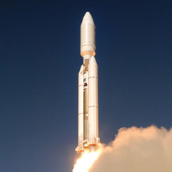
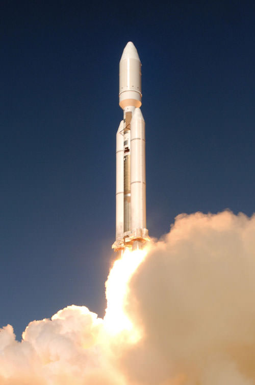
Final Titan 4 lifting off. Image credit: Lockheed Martin. Click to enlarge.
The United States Air Force and Lockheed Martin (LMT:NYSE) closed out a proud five-decade history today with the final launch of a Titan IV B rocket carrying a critical national security payload for the National Reconnaissance Office (NRO). All eyes were on Space Launch Complex 4 East as the nation’s heavy-lift workhorse thundered off the pad to deliver its final payload to space and retire from service.
“Today’s spectacular launch is a fitting way to say goodbye to Titan,” said G. Thomas Marsh, executive vice president of Lockheed Martin Space Systems Company. “The Lockheed Martin employees who have given their utmost efforts to the program over the years join with our Air Force and NRO customers, and the many other organizations that make up the Titan team, in expressing our great pride in this service to our country’s space program.”
Today’s launch was the last launch for the Titan IV and the culmination of a long evolution from the original Titan I intercontinental ballistic missile. In all, 39 Titan IVs have been launched – 12 Titan IVs have been launched from Vandenberg Air Force Base on the West Coast plus 27 more from the Cape Canaveral Air Force Station, Fla. The final Titan IV mission from Cape Canaveral was launched successfully April 29, 2005.
Col. Michael T. Baker, director, Launch Programs, Space and Missile Systems Center, Air Force Space Command, said, “The members of the System Program Office are extremely proud to be part of this historic launch. I am particularly honored to lead this SPO since Titan has been a part of my career since 1981. We have been confident from the beginning that the Titan team would deliver one final mission success for the nation.”
Following the Space Shuttle Challenger tragedy in 1986, when assured access to space became critical for the U.S. government, the Titan IV was developed as the booster used to launch the nation’s largest, heaviest and most critical payloads. Titan initial IV A design was followed by Titan IV B with a new generation of large solid rocket motors, state-of-the-art guidance and electronics and a new ground processing system.
“Today’s launch marks the end of an NRO Titan era but the beginning of the Titan Legend that will live on in the history of America’s space program,” said Col. Chip Zakrzewski, National Reconnaissance Office mission director.
Lockheed Martin Space Systems Company built the Titan IVs near Denver, Colo., under contract to the U.S. government. As prime contractor and systems integrator, the company built the first and second stages and provides overall program management and launch services. Other members of the Titan IV contractor team and their responsibilities include: GenCorp Aerojet Propulsion Division, Sacramento, Calif., liquid rocket engines; Alliant Techsystems, Magna, Utah, solid rocket motor upgrade; The Boeing Company, Huntington Beach, Calif., payload fairing; and Honeywell Space Systems, Clearwater, Fla., advanced guidance.
Original Source: Lockheed Martin News Release
Hubble’s view of the Moon. Image credit: Hubble. Click to enlarge.
NASA is using the unique capabilities of the Hubble Space Telescope for a new class of scientific observations of the Earth’s moon.
Hubble’s resolution and sensitivity to ultraviolet light have allowed the telescope to search for important oxygen-bearing minerals on the moon. Since the moon does not have a breathable atmosphere, minerals, such as ilmenite (titanium and iron oxide), may be critical for a sustained human lunar presence. Ilmenite is a potential source of oxygen for breathing or to power rockets.
The new Hubble observations are the first high-resolution, ultraviolet images ever acquired of the moon. The images provide scientists with a new tool to study mineral variations within the lunar crust. As NASA plans future expeditions to the moon, such data, in combination with other measurements, will help ensure the most valuable sites are targeted for robotic and human missions.
“These observations of the moon have been a challenging and highly successful technological achievement for NASA and the Hubble team, since the telescope was not originally designed for lunar observations,” said Jennifer Wiseman, program scientist for the Hubble at NASA Headquarters. “The images will inform both scientific studies of lunar geology and future decisions on further lunar exploration,” she said.
Hubble’s Advanced Camera for Surveys snapped ultraviolet and visible light images of known geologically diverse areas on the side of the moon nearest Earth. These included the Aristarchus impact crater and the adjacent Schroter’s Valley. Hubble also photographed the Apollo 15 and 17 landing sites, where astronauts collected rock and soil samples in 1971 and 1972.
Scientists are comparing the properties of the rock and soil samples from the Apollo sites with the new Hubble images, and the Aristarchus region, which neither humans nor robotic spacecraft have visited. The Hubble observations of Aristarchus crater and Schroter’s Valley will help refine researchers’ understanding of the diverse, scientifically interesting materials in the region and to unravel their full resource potential.
“Our initial findings support the potential existence of some unique varieties of oxygen-rich glassy soils in both the Aristarchus and Apollo 17 regions. They could be well-suited for visits by robots and human explorers in efforts to learn how to live off the land on the moon,” said Jim Garvin, chief scientist at NASA’s Goddard Space Flight Center, Greenbelt, Md. Garvin is principal investigator for the project.
“While it will require many months before fully quantitative results can be developed, we already have evidence that these new observations will improve the precision by which we can understand materials such as ilmenite to help better inform exploration decisions,” Garvin said.
Hubble’s lunar observation analysis team included colleagues from Goddard and Cornell University, Ithaca, N.Y.; Brown University, Providence, R.I.; Northwestern University, Evanston, Ill.; the University of Pittsburgh.; and the University of Hawaii, Manoa.
The Hubble Space Telescope is a project of international cooperation between NASA and the European Space Agency. The Space Telescope Science Institute in Baltimore conducts Hubble science operations. It is operated for NASA by the Association of Universities for Research in Astronomy, Inc., Washington, under contract with Goddard.
Original Source: Hubble News Release
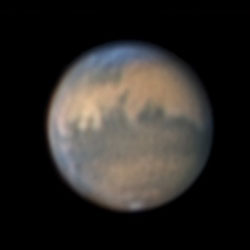
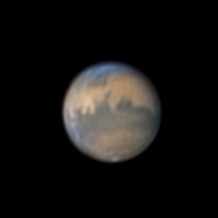
Mars on October 17?18, 2005, as recorded by Sky & Telescope assistant editor Sean Walker. Image credit: Sky and Telescope. Click to enlarge.
Look east late these evenings and you’ll see a big, fiery yellow “star” shining much brighter than any other. This is the planet Mars, and it’s passing unusually close to Earth during late October and early November 2005. Anyone can see it ? no matter how little you know about the stars or how badly light-polluted your sky may be.
During mid- to late October, look for Mars glaring low in the east after 8 p.m. local daylight-saving time. In November, it’s there in view as early as 6 p.m. standard time. Later in the evening, Mars climbs higher into better view and shifts over to the southeast. There’s nothing else nearly as bright that you can confuse it with.
Mars will be its closest to Earth on the night of October 29?30, passing 43.1 million miles (69.4 million kilometers) from our planet around 11:25 p.m. on the 29th Eastern Daylight Time. However, Mars will look just about as big and brilliant for a couple of weeks before and after that date.
Mars is at opposition (opposite the Sun in our sky) on November 7th. This means it rises at sunset, is up all night, and sets at sunrise.
This is the nearest that Mars has come since its record-breaking close approach in August 2003. At that time it passed by at a distance of only 34.7 million miles (55.8 million kilometers), the closest it had come in nearly 60,000 years. But for amateur telescope users, now is still a very special time. The planet will reach an apparent diameter of 20.2 arcseconds (the angular size of a penny seen at a distance of 620 feet), offering an usually detailed view of its surface. That compares with 25.1 arcseconds in August 2003 (the angular size of a penny at 500 feet), and only 15.9 arcseconds at Mars’s next swing-by, in December 2007 (a penny at 800 feet).
In fact, not until the summer of 2018 will Mars again come as close to Earth as it is right now (this statement remains true until mid-November).
Moreover, this year skywatchers at the latitudes of North America and Europe have a big advantage they didn’t have in 2003. That year Mars was far south in the sky and never got very high for telescope users at mid-northern latitudes. But this time Mars is farther north and rises higher during the night, affording a sharper, cleaner view in a telescope through Earth’s blurry atmosphere.
Telescope Tips
Good as this fall’s showing is, surface details on Mars are always a pretty tough target in a telescope. To begin with, Mars is only about half the size of Earth. Even at its closest, under high magnification it will appear as only a surprisingly small, bright ball with some subtle dark markings, possible white clouds around its edges, and perhaps a tiny remnant of the white South Polar Cap shrunken in the warmth of the Martian summer. The brightest yellow areas are deserts covered by fine, windblown dust. The darker markings are terrain displaying more areas of bare rock or darker sand and dust. Mars rotates every 24? hours, so you can see it turning in just an hour or two of watching.
To see much detail on Mars, several things all have to be working in your favor. You?ll need at least a moderately large telescope with high-quality optics. (For the lowdown on how to select a telescope wisely, see Sky & Telescope’s article “Choosing Your First Telescope”.) And you?ll need to wait until Mars rises high in the sky, well above the thick, murky layers of Earth’s atmosphere near the horizon. Moreover, the atmospheric “seeing” must be good. This is the astronomer?s term for the constant fuzzing and shimmering of highly magnified telescopic images due to the tiny heat waves that are always rippling through the atmosphere. The seeing changes from night to night and sometimes from moment to moment.
More about Mars and its unusual close approach appears in the September issue of Sky & Telescope and in the November/December 2005 issue of Night Sky, our new bimonthly magazine for beginners
Original Source: Sky and Telescope News Release
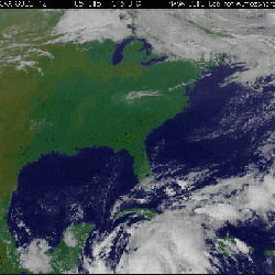
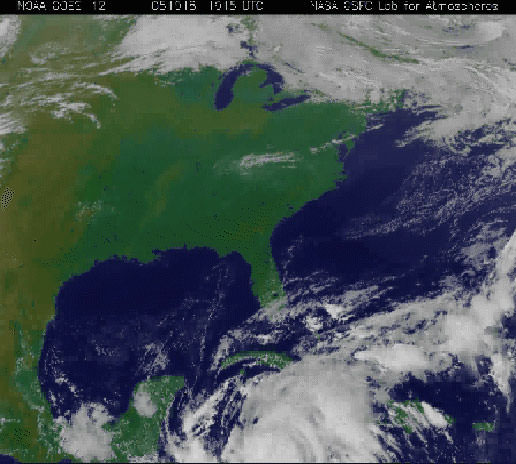
Satellite view of Hurricane Wilma. Image credit: NASA/NOAA. Click to enlarge.
In the early morning hours of Wednesday, October 19 in the warm Caribbean waters, Hurricane Wilma strengthened from a Category 2 hurricane to the most intense Hurricane 5 hurricane on record.
Hurricanes are measured by factors such as atmospheric pressure, winds and storm surge. Wilma’s atmospheric pressure at 8 a.m. EDT measured 882 millibars. The previous record was 888 millibars set in 1988 by Hurricane Gilbert that moved through the Gulf of Mexico.
At 8 a.m. Wednesday, October 19, Wilma was packing maximum sustained winds of 175 mph (280 km/hr) with higher gusts. Wilma’s center was located near latitude 17.2 north and longitude 82.8 west or about 340 miles (550 km) southeast of Cozumel, Mexico. Wilma is moving toward the west-northwest near 8 mph (13 km/hr). A turn toward the northwest is expected during the next 24 hours.
According to the National Hurricane Center, Wilma is a potentially catastrophic Category 5 hurricane on the Saffir-Simpson scale. Fluctuations in intensity are common in hurricanes this intense and are likely during the next 24 hours.
Wilma is a smaller storm than Katrina. Wilma’s hurricane force winds extend outward to 15 miles (30 km) from the center and tropical storm force winds extend outward up to 160 miles (260 km).
Based on data from dropsondes, instruments that are dropped into the storm from Hurricane Hunter planes that fly over it, and flight-level data from an Air Force plane, Wilma’s minimum central pressure is estimated to be 882 millibars (26.05 inches). This is the lowest pressure on record for a hurricane in the Atlantic basin.
Rainfall by Wilma is expected to be high. Wilma is expected to produce storm total accumulations of 10 to 15 inches with local amounts near 25 inches in mountainous terrain across Cuba through Friday. Additional rainfall accumulations of 5 to 10 inches, with local amounts of 15 inches, are possible across the Cayman Islands, Swan Island and Jamaica through Thursday.
From Honduras northward to the Yucatan peninsula of Mexico through Thursday, storm total accumulations of 4 to 6 inches, with isolated amounts of 8 to 12 inches are possible.
Watches and warnings have been posted throughout the region. A hurricane watch is in effect for the east coast of the Yucatan Peninsula from Cabo Catoche to Punta Gruesa. A hurricane watch is also in effect for Cuba in the provinces of Matanzas westward through Pinar del Rio and for the Isle of Youth. A hurricane watch means that hurricane conditions are possible within the watch area, generally within 36 hours.
Tropical storm warnings are up for Honduras from the Honduras/Nicaragua border westward to Cabo Camaron. A tropical storm warning and a hurricane watch remain in effect for the Cayman Islands.
Current forecast models project Wilma making landfall in southwest Florida on Saturday, Oct. 22 or Sunday, Oct. 23. All residents in the Florida Keys and the Florida peninsula should closely monitor the progress of extremely dangerous Hurricane Wilma. Story credit: Rob Gutro, NASA
Original Source: NASA News Release
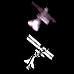
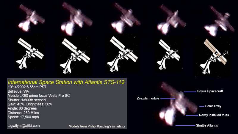
Atlantis docked with ISS. Image credit: Tom Gwilym. Click to enlarge.
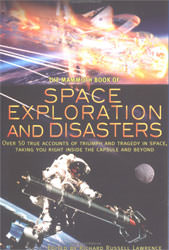
Humans and high speed vehicles have been getting together for a long time. The need for added speed keeps us experimenting. From two horse chariots to four horse, or galleons to schooners, we keep finding ways of getting ourselves moving faster and further. Rocket power swiftly followed the advent of planes, giving us freedom from the grip of land. Then ballistic missiles sent us past the slight friction of our atmosphere and into the near complete emptiness of space. With every advent of new technology and speed, there were flaws and errors. A chariot wheel fractures and dumps the drivers onto the ground. This may lead to no more than a bruised ego. But, when a thin ring of rubber fails on a rocket, the results are much more disastrous. Sad as this may be, one of humanity’s common traits is a greater interest in failures than successes. Hence, though we have made many successful flights into space, it is the failures that interest most people, even a long time after the event and it is this trait that gets treated with this book.
To satisfy this interest, Richard Lawrence has compiled a collection of stories, narrations and articles. These cover the time from planes using rockets in 1953 to the launch of the Rosetta mission in 2004. There is Neville Duke an early air speed record holder who describes rocket flight. Chuck Yeager powers through a description of his first transition through the sound barrier. Buzz Aldrin depicts Apollo 11’s landing, while Lovell repaints his sojourn in Apollo 13. As well, Lawrence with Bryan Burrough, provide their own rendition of the time a Progress supply vessel crashes into the Mir space station. These and others in the collection bring back to life many of the most memorable crises of humans and rocketry.
In addition to the events themselves, the styles of the presentations show the maturation of the technology. The early stories usually refer to only one person who was fully integrated with the craft and often referred to it as an extension of themselves. Later narrations, in particular the very dry excerpts from the commission’s report on the Challenger and Columbia accidents, show the remote controlled nature of flight even to the associated communications. Exceptions do occur though as Jerry Linenger eloquently echos his feelings of almost uncontrollable terror while dangling in the void of space at the end of a boom extending from the Mir station.
In editing, Richard Lawrence chose an excellent collection of narrations covering humans and rocketry. By selecting first hand accounts, or very well placed second hand accounts, he continually places the reader directly at the event. He provides clarification by adding a few paragraphs before each selection to aid the reader in understanding the situation. Though these articles represent a quite superficial and somewhat negative view of humanity’s progress with rocketry, as indicated by the sensationalist title, still many youths might be pleasantly swayed by much of the emotional delivery. That is except for the very dry and bureaucratic style of the selections for the Challenger and Columbia accidents. Certainly there are other thoughtful, technically accurate and strongly emotional narrations for these.
For many good and bad reasons, people contentedly place themselves into perilous situations. Perhaps this is the nature of humanity, to offer your singular service for the greater good. In the book edited by Richard Russell Lawrence entitled Space Exploration and Disasters, there are many stories of people striving to do their best against some astounding challenges. And, as often seen, people were able to adapt, apply innovative thinking and respond successfully.
Review by Mark Mortimer
Read more reviews online, or purchase a copy from Amazon.com.