Astrophoto: Abell 34 by Jim Misti

Abell 34 by Jim Misti
Most stars do not end their existence in a cataclysmic supernova explosion. For example, our Sun is more typical and someday, in the remote future, the location of our local star will look something like this picture of a distant planetary nebula.

Suns are born from vast clouds of dust and gas that gather in the dark places between the stars. Gravity causes these interstellar vapors to collapse inward until the pressure causes high enough temperatures at its center to fuse hydrogen, the universe’s basic building block, into helium – an event that also releases gamma-ray photons. These photons can take a million years to travel outward through the overlying matter until they reach the surface and escape into space as visible light. The push of the photon’s rush to make an exit also stops the cloud’s collapse and thus what began as thin gas and dust becomes a shining star illuminating the heavens. For billions of years stars, similar to our sun, shine predictably until the hydrogen starts to give out. Then through a series of steps, helium is fused into a succession of elements and the star expands enormously; eventually throwing off its outer surface like a spherical shell. This ends the star’s previous life and marks its passing with a ghostly shroud known as a planetary nebula.

George Abell was a professor at UCLA and an admired research astronomer who began is career as a tour guide at the Griffith Observatory in Los Angeles. As an astronomer, he was best known for his work at Mt. Palomar with the first photographic sky survey conducted in the 1950’s. He cataloged galaxy clusters and contributed to our understanding of their formation and evolution. He also compiled a catalog of 86 faint planetary nebulas discovered as he studied the sky plates taken with Palomar’s 48 inch Oschin Schmidt Telescope.

This planetary nebula is number 34 in Abell’s listing and is located in the constellation of Hydra. It is very faint and has a low surface brightness thus making it very hard to see or photograph, even with a large telescope.

Astronomer Jim Misti produced this exceptional image over three nights in February 2006 using his personal 32-inch telescope located in a dark remote spot in Arizona. The light grasp of Jim’s instrument is several thousand times greater than the unaided eye yet the faintness of this nebula still required over four hours of accumulated exposure time to take this full color picture. Notice, also, the small galaxies located much farther in the distance.

Do you have photos you’d like to share? Post them to the Universe Today astrophotography forum or email them, and we might feature one in Universe Today.

Written by R. Jay GaBany

What’s Up This Week – April 3 – April 9, 2006

What's Up 2006

Download our free “What’s Up 2006” ebook, with entries like this for every day of the year.

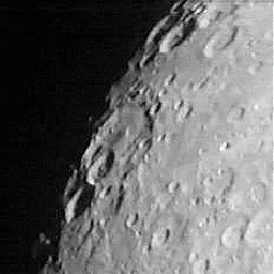
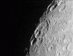
Craters Steinheil and Watt. Image credit: Tammy Plotner. Click to enlarge.
Greetings, fellow SkyWatchers! We’ll take a journey to the Moon this week as we explore some outstanding features that make our “neighbor” such a fascinating target. ‘Tis also the season for aurora and we’ll find out why. Be sure to be on watch for meteors and get out the scope to play, because….

Here’s what’s up!

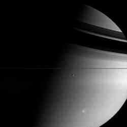
Monday, April 3 – Today marks the 40th anniversary of the launch of the first lunar orbiter – Luna 10. That makes another good reason to view the Moon tonight!

Just a short distance north of the southern cusp, look for a twin pair of craters on the terminator tonight. These are Steinheil and Watt. The two are nearly identical in size an overlap each other. Steinheil, named for mathematician, physicist, optician, and astronomer Karl August von Steinheil is just bit deeper and to the north. Watt, named for my great gandfather James Watt, Scottish engineer and first man to patent the use of a telescope for surveying, will show a wee bit more detail on its floor.

Right now Earth’s magnetosphere and magnetopause are positioned correctly to interact with the Sun’s influencing interplanetary magnetic field (IMF) – and the plasma stream which flows past us as solar winds. During this time after equinox, this phenomenon leaves the door wide open for one of the most awesome signs of spring – aurora! Visit the Geophysical Institute to sign up for aurora alerts and use their tools to help locate the position of the Earth’s auroral oval.

Tuesday, April 4 – Tonight through binoculars or a telescope, let’s head toward the Moon’s southern quadrant and view Theophilus. Located on the terminator and bordered on the northern edge by Mare Nectaris and to the south by Mare Tranquillitatis, Theophilus has an average diameter of 105 km and contains a wonderful multiple-peaked center. This particular crater is unusual because the floor is parabolic. The interior may be dark, but you should see the Sun catching the summit of its huge central peak.

After the Moon sets, keep the watch for the Kappa Serpentid meteor shower. Its radiant lies near the “Northern Crown” – Corona Borealis. The fall rate is low, with an average 4 or 5 per hour.

Tonight will be the last chance for deep sky studies before the Moon dominates, so let’s take advantage. Did you know that there is a galaxy in Cancer? OK – so you did… But, did you know that the galaxy NGC 2775 has been home to 5 supernovae in the last 30 years, or that it’s one of the most unusual but otherwise perfect spiral shapes in the heavens? Then, get a scope out and start by locating Alpha Cancri and head not quite a fist’s width southeast and in line with Zeta Hydrae. NGC 2775 is a 10.3 magnitude oval of luminosity within a low power field.

Wednesday, April 5 – There’s plenty of Moon to explore tonight, so why not try locating an area where many lunar missions left their mark? Binoculars easily reveal the fully disclosed mares of Serenitatis and Tranquillitatis. Set your sites where these two vast lava plains converge. Telescopically you will see a bright “peninsula” where they meet in the west. Look for bright and small crater Pliny to the east of this point.

It is near this rather inconspicuous feature that the remains of Ranger 6 lay forever preserved after “crash-landing” on February 2nd, 1964. Unfortunately, technical errors prevented Ranger 6 from transmitting lunar pictures. Not so Ranger 8! On a very successful mission to the same basic area, NASA received 7137 “postcards from the near side of the Moon” for 23 minutes before a very hard landing. On the “softer side,” Surveyor 5 touched down near this area safely after two days of malfunctions on September 10, 1967. Incredibly, the tiny Surveyor 5 endured temperatures of up to 283 degrees F, but still spectrographically analyzed the area’s soil and also managed to televise over 18,000 frames of “home movies” from its distant lunar location.

Tonight let’s “see double.” At magnitude 2.5, Gamma Leonis – or Algieba – is second brightest member of the Leo “question mark.” Now we have a question for you. Did you know that Algieba is among the most lovely pairs in the night sky? See for yourself! Separated by less than 5 arc seconds, the primary appears ivory, while the secondary is golden. Those with smaller scopes will enjoy the beauty of the “airy disks” displayed by this pair.

Thursday, April 6 – Tonight let’s return to a now familiar lunar feature, Albategnius. A fine challenge for binoculars will be to see if you can make out its bright central peak from the darker lava-covered floor. Power up with a telescope for another challenge. Can you spot the small craters Vogel and Burnham on its southeast edge? Or Ritchey just outside its eastern wall? Look for craters Halley and Hind just between Albategnius and Hipparchus to the north. Hipparchus also holds a very detailed small crater named Horrocks on its northern wall. Shallow crater Saunder is just to its east.

Ready for another challenge? Then let’s head for Iota Leonis – just south of the triangle that makes up eastern Leo. At magnitude 4, it will be difficult to see its close 7th magnitude companion. This is known as a disparate double – a pair unevenly matched in brightness. One of the most difficult double stars in the heavens!

Friday, April 7 – Today in 1991, the Compton Gamma Ray Observatory (GRO) was deployed. Part of NASA’s Great Observatories program, the CGRO was named to honor Dr. Arthur Holly Compton – a Nobel Prize winning physicist. CGRO scanned six decades of electromagnetic radiation at energy ranges well beyond anything the eye can see. Such energies often happen in bursts as extraordinary and cataclysmic events occur in the cosmos.

Be sure to take your telescope out and have a look at the Moon tonight. One of the most sought-after and unusual features will be visible in the southern half of the Moon near the terminator – Rupes Recta! Also known as “The Straight Wall,” this 130 km (75 mile) long, 366 meter (1200 ft) high feature slopes upward with the steepest angle on the lunar surface (41 degrees). It will be a challenge under these lighting conditions, but look for triple ring of craters Ptolemy, Alphonsus, and Arzachel to guide you. The “Straight Wall” appears as a very thin line stretching across the edge of Mare Nubium.

Be on the lookout for bright streaks from the Delta Draconid meteor shower. Its radiant lies near the border with Cepheus to the east. The fall rate is quite low – around 5 meteors per hour.

Even with the Moon, let’s try for a scattered open cluster toward the west in Auriga. At magnitude 5.4, NGC 2281 should be visible as a nebulous mist in binoculars on a dark night, but you’ll need a scope and high power to darken the sky enough to see the bright members found near its core. NGC 2281 is around 1500 light years distant and 50 million years old. It can best be found by extending a line from Capella to Beta Aurigae an equal distance east to a pair of 5th magnitude stars separated by a finger width. NGC 2281 lies less than one degree southeast of the eastern member of this pair (58 Aurigae.)

Saturday, April 8 – Start your evening by revisiting crater Copernicus as it becomes visible to even the most modest of optical aids. Small binoculars will see Copernicus as a bright “ring” about midway along the lunar dividing line of light and dark called the “terminator.” Telescopes will reveal its 97 km (60 mile) expanse and 120 meter (1200 ft.) central peak to perfection. Copernicus holds special appeal as the aftermath of a huge meteoric impact! At 3800 meters deep, its walls are 22 km thick. Over the next few days, the impact ray system extending from this tremendous crater will become wonderfully apparent.

Tonight we’ll use Copernicus as a guide and look north-northwest to survey the Carpathian Mountains. The Carpathians ring the southern edge of Mare Imbrium beginning well east of the terminator. But let’s look on the dark side. Extending some 40 km beyond into the Moon’s own shadow, you can continue to see bright peaks – some reaching 2000 meters high! Tomorrow, when this area is fully revealed, you will see the Carpathians begin to disappear into the lava flow forming them. Continuing onward to Plato – on the northern shore of Mare Imbrium – look for the singular peak of Pico. Between Plato and Mons Pico you will find the many scattered peaks of the Teneriffe Mountains. It is possible that these are the remnants of much taller summits of a once precipitous range. Now the peaks rise less than 2000 meters above the surface. Time to power up! West of the Teneriffes, and very near the terminator, you will see a narrow line of mountains, very similar in size to the Alpine Valley. This is known as the Straight Range and some of its peaks reach as high as 2000 meters. Although this doesn’t sound particularly impressive, that’s over twice as tall as the Vosges Mountains in west central Europe and on average, comparable to the Appalachian Mountains of the eastern United States.

Sunday, April 9 – Tonight let’s continue our lunar mountain climbing expedition and revisit the “big picture” on the lunar surface. Tonight all of Mare Imbrium is bathed in sunlight and we can see its complete shape. Appearing as a featureless ellipse bordered by mountain ranges, let’s identify them all again. Starting at Plato and moving east to south to west you will find the Alps, the Caucasus, the Apennine and the Carpathians mountains. Look at the form closely=85doesn’t it look like it’s possible that an enormous impact created the entire area? Compare it to the younger Sinus Iridium ringed by the Juras Mountains. It may have also been formed by a much later and very similar massive impact event.

In the mood for a double star? Then let’s head west and away from the Moon. Begin your search right after skydark with El Nath – Beta Tauri. From Beta shift about two finger-widths east-northeast to identify very dim 26 Aurigae. At low power, look for an 8th magnitude companion due west of the 5.5 magnitude primary. The brighter star should give a warm yellow appearance while the fainter appears slightly more blue. This pair shares space with a third member (magnitude 11.5) – some three times further out from the primary than the closer, brighter secondary. Thanks to lunacy, small instruments will have difficulty distinguishing the C star in such bright skies.

May all your journeys be at light speed… ~Tammy Plotner. (contributing writer: Jeff Barbour).

Mars Aerobraking Begins

Image showing the heat being emitted from the day and night side of Mars. Image credit: NASA Click to enlarge
Now firmly in orbit around the Red Planet, NASA’s Mars Reconnaissance Orbiter has begun a series of maneuvers through the atmosphere to slow itself down even further. The process is called aerobraking, and each successive pass slows it down a little bit, lowering its orbit. After 6 months of aerobraking, sweeping through the atmosphere 550 times, the spacecraft will be in its final science orbit.

NASA’s Mars Reconnaissance Orbiter yesterday began a crucial six-month campaign to gradually shrink its orbit into the best geometry for the mission’s science work.

Three weeks after successfully entering orbit around Mars, the spacecraft is in a phase called “aerobraking.” This process uses friction with the tenuous upper atmosphere to transform a very elongated 35-hour orbit to the nearly circular two-hour orbit needed for the mission’s science observations.

The orbiter has been flying about 426 kilometers (265 miles) above Mars’ surface at the nearest point of each loop since March 10, then swinging more than 43,000 kilometers (27,000 miles) away before heading in again. While preparing for aerobraking, the flight team tested several instruments, obtaining the orbiter’s first Mars pictures and demonstrating the ability of its Mars Climate Sounder instrument to track the atmosphere’s dust, water vapor and temperatures.

On Thursday, Mars Reconnaissance Orbiter fired its intermediate thrusters for 58 seconds at the far point of the orbit. That maneuver lowered its altitude to 333 kilometers (207 miles) when the spacecraft next passed the near point of its orbit, at 6:46 a.m. Pacific time today (9:46 a.m. Eastern Time).

“We’re not low enough to touch Mars’ atmosphere yet, but we’ll get to that point next week,” said Dr. Daniel Kubitschek of NASA’s Jet Propulsion Laboratory, Pasadena, Calif., deputy leader for the aerobraking phase of the mission.

The phase includes about 550 dips into the atmosphere, each carefully planned for the desired amount of braking. At first, the dips will be more than 30 hours apart. By August, there will be four per day.

“We have to be sure we don’t dive too deep, because that could overheat parts of the orbiter,” Kubitschek said. “The biggest challenge is the variability of the atmosphere.”

Readings from accelerometers during the passes through the atmosphere are one way the spacecraft can provide information about upward swelling of the atmosphere due to heating.

The Mars Climate Sounder instrument also has the capability to monitor changes in temperature that would affect the atmosphere’s thickness. “We demonstrated that we’re ready to support aerobraking, should we be needed,” JPL’s Dr. Daniel McCleese, principal investigator for the Mars Climate Sounder, said of new test observations.

Infrared-sensing instruments and cameras on two other Mars orbiters are expected to be the main sources of information to the advisory team of atmospheric scientists providing day-to-day assistance to the aerobraking navigators and engineers. “There is risk every time we enter the atmosphere, and we are fortunate to have Mars Global Surveyor and Mars Odyssey with their daily global coverage helping us watch for changes that could increase the risk,” said JPL’s Jim Graf, project manager for the Mars Reconnaissance Orbiter.

Using aerobraking to get the spacecraft’s orbit to the desired shape, instead of doing the whole job with thruster firings, reduces how much fuel a spacecraft needs to carry when launched from Earth. “It allows you to fly more science payload to Mars instead of more fuel,” Kubitschek said.

Once in its science orbit, Mars Reconnaissance Orbiter will return more data about the planet than all previous Mars missions combined. The data will help researchers decipher the processes of change on the planet. It will also aid future missions to the surface of Mars by examining potential landing sites and providing a high-data-rate communications relay.

Test observations from the Mars Climate Sounder, other images and additional information about Mars Reconnaissance Orbiter are available online at http://www.nasa.gov/mro and at http://marsprogram.jpl.nasa.gov/mro .

For information about NASA and agency programs on the Web, visit http://www.nasa.gov .

Original Source: NASA News Release

The Storm Rages On

Giant Saturn and its moon Tethys. Image credit: NASA/JPL/SSI. Click to enlarge
This Cassini photograph shows half of Saturn shrouded in shadow, with its moon Tethys hanging in the foreground. A gigantic storm that was first sighted in January 2006 continues to rage in Saturn’s southern hemisphere. This image was taken on February 18, 2006, when Cassini was 2.8 million kilometers (1.7 million miles) from Saturn.

The Cassini spacecraft looks toward giant Saturn and its moon Tethys, while a large and powerful storm rages in the planet’s southern hemisphere. The storm was observed by the Cassini spacecraft beginning in late Jan. 2006, and was at the time large and bright enough to be seen using modest-sized telescopes on Earth.

The fact that the storm stands out against the subtle banding of Saturn at visible wavelengths suggests that the storm’s cloud tops are relatively high in the atmosphere.

Tethys is 1,071 kilometers (665 miles) across.

The image was taken in visible light with the Cassini spacecraft wide-angle camera on Feb. 18, 2006, at a distance of approximately 2.8 million kilometers (1.7 million miles) from Saturn. The image scale is 162 kilometers (101 miles) per pixel on Saturn.

The Cassini-Huygens mission is a cooperative project of NASA, the European Space Agency and the Italian Space Agency. The Jet Propulsion Laboratory, a division of the California Institute of Technology in Pasadena, manages the mission for NASA’s Science Mission Directorate, Washington, D.C. The Cassini orbiter and its two onboard cameras were designed, developed and assembled at JPL. The imaging operations center is based at the Space Science Institute in Boulder, Colo.

For more information about the Cassini-Huygens mission visit http://saturn.jpl.nasa.gov . The Cassini imaging team homepage is at http://ciclops.org .

Original Source: NASA/JPL/SSI News Release

Waves in the Earth’s Magnetic Tail

Double Star TC-2 spacecraft. Image credit: ESA. Click to enlarge
Like many comets when they get close to the Sun, the Earth has a tail. But instead of a shower of icy particles, it’s the Earth’s magnetic field that gets pushed into a long trail directed away from the Sun. Five spacecraft from ESA – the 4 Cluster spacecraft and DoubleStar – recently observed how this magnetotail can experience strange turbulence through its interaction with the Sun’s solar wind and coronal mass ejections. How and why this phenomenon happens is still a mystery.

Five spacecraft from two ESA missions unexpectedly found themselves engulfed by waves of electrical and magnetic energy as they travelled through Earth’s night-time shadow on 5 August 2004.

The data collected by the spacecraft are giving scientists an important clue to the effects of ‘space weather’ on Earth’s magnetic field.

Shortly after 15:34 CEST, something set the tail of Earth’s natural cloak of magnetism oscillating. “It was like the waves created by a boat travelling across a lake,” says Dr Tielong Zhang of the Austrian Academy of Sciences, Graz.

Only in this case, the identity of the ‘boat’ is unknown. It might be the fast flow of particles often observed in the central part of the magnetotail. Whatever it was produced waves that travelled from the centre of the tail to its outer edges.

The five spacecraft caught in this event were the four units of ESA’s Cluster mission and the first unit of the joint CNSA/ESA mission Double Star. The Cluster quartet fly in formation, passing through Earth’s magnetotail at distances of between 16 and 19 times Earth’s radius.

One of the two spacecraft of Double Star, the TC-1 spacecraft, orbits at between 10 and 13 Earth radii. All five spacecraft are designed to collect data on the magnetic bubble surrounding our planet, called the ‘magnetosphere’.

Earth’s magnetic field is generated deep inside the planet and rises into space where it constantly interacts with the solar wind, a perpetual stream of electrically charged particles released by the Sun.

The stream pulls Earth’s magnetic field into a tail that stretches behind the planet for tens of thousands of kilometres. Gusts and storms in the solar wind are known as ‘space weather’ and can make Earth’s magnetic field quake.

On 5 August 2004, Cluster and Double Star satellites found themselves in the right place at the right time. The readings showed that the oscillations took place simultaneously across an area over 30 000 km in length. This is the first time that the true extent of the oscillations has been revealed.

Previous Cluster measurements, before the launch of Double Star, could only reveal the movement across a restricted location surrounded by the four satellites.

Understanding the way Earth’s magnetic field interacts with the solar wind is the space-age equivalent of a meteorologist investigating the way a mountain range disturbs airflow, creating weather systems.

In the case of space weather, storms consist of fluctuating magnetic and electrical fields that can damage satellites and pose health risks to astronauts. If we are to fully exploit the potential of space, we have to understand the effects of space weather and be able to predict them. That’s where missions like Cluster and Double Star come in.

“By studying the August oscillations, we may be able to develop a unifying theory for all the various motions of the magnetotail,” says Zhang, who is heading the investigation into what happened that day.

Original Source: ESA Portal

New Class of Saturn Moonlets Discovered

Small moonlets resides within Saturn’s rings. Image credit: NASA/JPL/SSI Click to enlarge
A whole new class of mini-moons have been discovered lurking inside Saturn’s rings. These tiny moons are about 100 metres (300 feet) across, and there could be as many as 10 million in total in the ring system. Scientists have wondered for many years if Saturn’s rings are the result of a larger object that was shredded by Saturn gravity millions of years ago, and these moonlets could help provide the answer. They would be remnants of the former object, and could give insights into what its structure was.

Scientists with NASA’s Cassini mission have found evidence that a new class of small moonlets resides within Saturn’s rings. There may be as many as 10 million of these objects within one of Saturn’s rings alone.

The moonlets’ existence could help answer the question of whether Saturn’s rings were formed through the break-up of a larger body or are the remnants of the disk of material from which Saturn and its moons formed.

“These moonlets are likely to be chunks of the ancient body whose break-up produced Saturn’s glorious rings,” said Joseph Burns of Cornell University, Ithaca, N.Y., a co-author of the report.

Careful analysis of high-resolution images taken by Cassini’s cameras revealed four faint, propeller-shaped double streaks. These features were found in an otherwise bland part of the mid-A Ring, a bright section in Saturn’s main rings. Cassini imaging scientists reporting in this week’s edition of the journal Nature believe the “propellers” provide the first direct observation of how moonlets of this size affect nearby particles. Cassini took the images as it slipped into Saturn orbit on July 1, 2004.

Previous measurements, including those made by NASA’s Voyager spacecraft in the early 1980s, have shown that Saturn’s rings contain mostly small water-ice particles ranging from less than 1 centimeter (one-half inch) across to the size of a small house. Scientists knew about two larger embedded ring moons such as 30-kilometer-wide (19-mile) Pan and 7-kilometer-wide (4-mile) Daphnis. The latest findings mark the first evidence of objects of about 100 meters (300 feet) in diameter. From the number of moonlets spotted in the very small fraction of the A ring seen in the images, scientists estimated the total number of moonlets to be about 10 million.

“The discovery of these intermediate-sized bodies tells us that Pan and Daphnis are probably just the largest members of the ring population, rather than interlopers from somewhere else,” said Matthew Tiscareno, an imaging team research associate at Cornell and lead author on the Nature paper.

Moons as large as Pan and Daphnis clear large gaps in the ring particles as they orbit Saturn. In contrast, smaller moonlets are not strong enough to clear out the ring, resulting in a partial gap centered on the moonlet and shaped like an airplane propeller. Such features created by moonlets were predicted by computer models, which give scientists confidence in their latest findings.

“We acquired this spectacular, one-of-a-kind set of images immediately after getting into orbit for the express purpose of seeing fine details in the rings that we had not seen previously,” said Carolyn Porco, Cassini imaging team leader and co-author. “This will open up a new dimension in our exploration of Saturn’s rings and moons, their origin and evolution.”

The detection of moonlets embedded in a ring of smaller particles may provide an opportunity to observe the processes by which planets form in disks of material around young stars, including our own early solar system. “The structures we observe with Cassini are strikingly similar to those seen in many numerical models of the early stages of planetary formation, even though the scales are dramatically different,” said co-author Carl Murray, an imaging team member at Queen Mary, University of London. “Cassini is giving us a unique insight into the origin of planets.”

For images showing the propeller-shaped features, visit: http://www.nasa.gov/cassini , http://saturn.jpl.nasa.gov and http://ciclops.org .

The Cassini-Huygens mission is a cooperative project of NASA, the European Space Agency and the Italian Space Agency. The Jet Propulsion Laboratory, a division of the California Institute of Technology in Pasadena, manages the Cassini-Huygens mission for NASA?bfs Science Mission Directorate, Washington. The Cassini orbiter and its two onboard cameras were designed, developed and assembled at JPL. The imaging team is based at the Space Science Institute, Boulder, Colo.

Original Source: NASA/JPL/SSI News Release

Space Station Captures Images of the Solar Eclipse

The moon shadow falls on Earth as seen from the ISS. Image credit: NASA Click to enlarge
The Moon passed in front of the Sun on March 29, 2006, right on schedule, and skywatchers across Africa, the Middle East and Asia were treated to a total solar eclipse. But astronauts on board the International Space Station got to see the eclipse from a unique perspective: from space. They saw the Moon obscure the Sun, but they could also see the Moon’s shadow darkening the Earth below them.

A circle of darkness moving quickly across a lengthy swath of the Earth on Wednesday triggered fascination and reaction from people around the world. An astronaut about to embark on a six-month space mission said that fascination is a reason humans work hard to shed light on the unknown.

The shadow of the moon moved in a northeasterly direction, beginning in Brazil and across the Atlantic, northern Africa, western China and Mongolia. Its longest totality duration was just over four minutes in western Libya, about 1,250 miles south of Tripoli a little after 5 a.m. EST.

Astronaut Jeffrey Williams said the reaction to the eclipse on the day of the launch of the 13th crew of the International Space Station reminds “all of us who work in the space exploration program just what our purpose is, for discovery and exploration, and understanding the unknown.”

He said such phenomena have, throughout history, inspired people to explore and discover, “to understand why things like that happen.”

Williams, the NASA science officer on the station’s Expedition 13 crew, is to launch with E13 Commander Pavel Vinogradov to the station today at 9:30 p.m. EST from the Baikonur Cosmodrome in Kazakhstan, where they spoke to media this morning, to begin their stay in space.

With them will be Marcos Pontes, Brazil’s first astronaut, who will spend about eight days on the station and return with the Expedition 12 crew, which is wrapping up its six-month stay in orbit. Pontes said he saw the eclipse as a good omen for the start of the mission.

Vinogradov said he found the event an interesting astronomical phenomenon. He said he had no opinion about whether it was good or bad.

Many people in the path of the eclipse were a good deal more excited about the event. Some likened it to the end of the world while others feared ill effects from the event. Some saw it as a religious experience.

Many, including some Americans who had traveled great distances to see the eclipse, said it was a fascinating and exciting natural phenomenon.

Vinogradov didn’t share their excitement.” We just know that the moon was between the Earth and the sun,” he said.

Original Source: NASA News Release

Cassini’s View of Jupiter’s South Pole

Jupiter as mapped by Cassini. Image credit: NASA/JPL/SSI Click to enlarge
Cassini took many photographs of Jupiter on the way to Saturn, including this unusual montage of its southern pole. This photograph was made up of 36 separate images, stitched together on computer. The planet looks strange because the photo is a polar stereographic projections, which shows the southern pole in the middle, and the equator at the edges. The original images were captured on December 11th and 12th, 2000.

These color maps of Jupiter were constructed from images taken by the narrow-angle camera onboard NASA’s Cassini spacecraft on Dec. 11 and 12, 2000, as the spacecraft neared Jupiter during its flyby of the giant planet. Cassini was on its way to Saturn. They are the most detailed global color maps of Jupiter ever produced; the smallest visible features are about 120 kilometers (75 miles) across. For other maps see PIA07782 and PIA07783. (Related thumbnail images available here.)

The maps are composed of 36 images: a pair of images covering Jupiter’s northern and southern hemispheres was acquired in two colors every hour for nine hours as Jupiter rotated beneath the spacecraft. Although the raw images are in just two colors, 750 nanometers (near-infrared) and 451 nanometers (blue), the map’s colors are close to those the human eye would see when gazing at Jupiter.

The maps show a variety of colorful cloud features, including parallel reddish-brown and white bands, the Great Red Spot, multi-lobed chaotic regions, white ovals and many small vortices. Many clouds appear in streaks and waves due to continual stretching and folding by Jupiter’s winds and turbulence. The bluish-gray features along the north edge of the central bright band are equatorial “hot spots,” meteorological systems such as the one entered by NASA’s Galileo probe. Small bright spots within the orange band north of the equator are lightning-bearing thunderstorms. The polar regions shown here are less clearly visible because Cassini viewed them at an angle and through thicker atmospheric haze.

The round maps are polar stereographic projections that show the north or south pole in the center of the map and the equator at the edge.

The Cassini-Huygens mission is a cooperative project of NASA, the European Space Agency and the Italian Space Agency. The Jet Propulsion Laboratory, a division of the California Institute of Technology in Pasadena, manages the mission for NASA’s Science Mission Directorate, Washington, D.C. The Cassini orbiter and its two onboard cameras were designed, developed and assembled at JPL. The imaging operations center is based at the Space Science Institute in Boulder, Colo.

For more information about the Cassini-Huygens mission visit http://saturn.jpl.nasa.gov . The Cassini imaging team homepage is at http://ciclops.org .

Original Source: NASA/JPL/SSI News Release

Libya Montes Valley on Mars

ESA’s Mars Express took this photograph of Libya Montes, which is south of the large Isidis Planitia impact basin on Mars. The region contains a 400 km (248 mile) long valley that was carved into the early Martian surface; probably by water when the planet was warm and wet. Scientists estimate that the same amount of water was probably flowing out of the region as middle reaches of the Mississippi river in the US.

These images, taken by the High Resolution Stereo Camera (HRSC) on board ESA’s Mars Express spacecraft, show the region of Libya Montes, south of the Isidis Planitia impact basin on Mars.

The HRSC obtained these images during orbit 922 with a ground resolution of approximately 14.3 metres per pixel at equatorial latitudes near longitude 81 degrees East.

The images show the central reaches of a 400-kilometre long valley that was carved into the surface in early Martian history, approximately 3500 million years ago.

The central parts of the broad valley show traces of an interior valley, documenting the flow of water that once occurred on the surface of the planet during periods of wetter climate.

Determinations of discharge volumes on the basis of high-resolution HRSC derived digital terrain models reveal discharge rates that are comparable to those of the middle reaches of the Mississippi river in the USA.

On the basis of crater-size frequency distributions on the valley floor and surrounding terrain it has been shown that the formation time of the valley amounts to approximately 350 million years.

Measurements of erosion rates suggest that the active phases of valley development are characterised by short periods of intense fluvial activity rather than sustained liquid flow.

Details on valley formation have been published by R. Jaumann (DLR) and colleagues, as an article ‘Constraints on fluvial erosion by measurements of the Mars Express High Resolution Stereo Camera’ in Geophysical Research Letters, 32, L16203, doi:10.1029/2005GL023415).

***image4:right***The colour scenes were derived from the three HRSC colour channels and the nadir channel. The perspective views have been calculated from the digital terrain model derived from the stereo channels.

The 3D anaglyph image was calculated from the nadir and one stereo channel. The black and white high-resolution images were derived from the nadir channel that provides the highest detail of all the channels.

Original Source: ESA Mars Express

Nearby Clouds of Gas are Stellar Nursaries in the Making

Astronomers from Boston University have carefully mapped the giant gas clouds in our region of the Milky Way, offering clues to the environment that helped create our Solar System. The team used a large radio telescope that captures high frequency radio waves. When viewed at this wavelength, the clouds are far more transparent, and their inner structure is revealed. All of the clouds they’ve studied so far are lumpy, and will eventually be the birthplaces of stars.

A team of astronomers from Boston University’s Institute for Astrophysical Research has produced the clearest map to-date of the giant gas clouds in the Milky Way that serve as the birthplaces of stars. Using a powerful telescope, the astronomers tracked emissions of a rare form of carbon monoxide called 13CO to chart a portion of our home galaxy and its star-forming molecular clouds.

The researchers hope the new illustration will aid in the identification of additional clouds and study of their internal structure to better understand the origin of stars like the sun, which began its life in such a cloud about 5 billion years ago. The data and images are published in the March issue of the Astrophysical Journal Supplement.

The eight-year project, called the Boston University-Five College Radio Astronomy Observatory (FCRAO) Galactic Ring Survey (GRS), was led by a team of astronomers based at BU, the University of Cologne in Germany, and the University of Massachusetts.

To produce the detailed image, the astronomers mapped the location of 13CO in the Milky Way using a large radio telescope operated by the FCRAO of the University of Massachusetts that captures and images radio emissions at a frequency near 100,000 MHz – about 1,000 times higher than FM stations. When viewed in the emission from 13CO, the clouds are far more transparent than the more traditionally studied 12CO which allowed the team to peer more deeply into their interior.

“The value of such high range imaging is that it enables us to identify the underlying patterns of gas distribution and speeds that point toward the key physical processes occurring within the molecular gas phase of the interstellar medium,” said Dr. Mark Heyer, a researcher from UMass involved in the project.

Using a new receiver developed at UMass, the astronomers could depict the structure of the clouds faster and with much finer detail than any previous attempts. As an added benefit, the distribution of the clouds also delineates the spiral structure of the Milky Way.

“Ironically, because we live inside the Milky Way, we know more about the shapes of far more distant galaxies better than our own,” said James Jackson, astronomy professor at BU and lead investigator of the study. “The GRS map helps us better understand the configuration of our home galaxy and its components.”

“Upon seeing the GRS image, I knew right away it was something terrific. It was like the first time I put on glasses as a kid, and wondered how I ever got along without knowing about every shape, contour and detail of the world around me,” said Dr. Ronak Shah, a researcher from BU who worked on the project. “The GRS has that affect on a lot of us. We thought we understood the Milky Way and then the GRS revealed so much more detail to explore.”

According to Dr. Robert Simon, now at the University of Cologne, but who started the project with Jackson in 1998 at BU, the information from the GRS will constitute an important new database for the study of molecular clouds and Milky Way structure for generations of astronomers.

The scientists are now closely analyzing the image and one of the initial findings is the probable identification of dark, cold molecular clouds in the earliest stages of star development.

“Data from the Galactic Ring Survey have shown that these clouds are the counterparts to active, bright star-forming clouds, but because they have not yet been heated by the embedded stars, they are much colder and quieter,” said Jackson. “Follow-up studies of these clouds will provide additional important clues about the origin of stars since we’ll be able to examine them at an earlier point in their life.”

Another interesting result is that all of the molecular clouds studied so far have similar lumpy structures, regardless of their size, mass, and star-forming activity. These lumps will eventually become stars and, according to the researchers, this similarity suggests that all clouds form stars of various masses in roughly the same proportion.

The Milky Way is a vast disk of 100 billion stars, gas, and dust and because it is flat, the map is long and narrow. Since most of the Galaxy lies in the southern skies, unreachable from Northern Hemisphere telescopes, and because many of the molecular gas clouds are concentrated toward its inner regions, only a portion was imaged.

The Institute for Astrophysical Research (IAR) was founded in 1998 in order to promote and facilitate research and education in astrophysics at Boston University. The IAR supports research by BU Astronomy faculty members, graduate and undergraduate students, and postdoctoral and senior research associates. In addition, the IAR manages and coordinates the use of astrophysical research facilities and promotes the design, development, and operation of instruments and telescopes for astronomical research.

Founded in 1839, Boston University is an internationally recognized institution of higher education and research. With more than 30,000 students, it is the fourth largest independent university in the United States. BU contains 17 colleges and schools along with a number of multi-disciplinary centers and institutes which are central to the school’s research and teaching mission.

Original Source: Boston University