Spacedev Puts a Satellite Up for Sale on eBay

Image credit: SpaceDev

Satellite manufacturer SpaceDev announced today that it has put a satellite up for sale on the Internet auction site eBay. The high bidder will win a spacecraft built by SpaceDev, or an interested party can just “Buy it Now” for $9.5 million USD. The auction begins on Monday, November 10 and ends 10 days later. The default satellite will come with an Earth observation camera, but the winning bidder can supply additional payloads, name the satellite, and attend the launch.

SpaceDev (OTCBB: SPDV) is auctioning a world exclusive private space mission on eBay. This first of its kind eBay auction is being listed for the ten-day period of 8:00 PM (PST) Monday, November 10, through 8:00 PM (PST) Thursday, November 20th.

The SpaceDev space mission auction is at:

http://cgi.ebay.com/ws/eBayISAPI.dll?ViewItem&item=2572382454&category=45046&rd=1

Most earth orbiting small satellite missions can cost $25 million or more, not including the launch. To demonstrate the affordability of private space missions, SpaceDev has posted a ?Buy it Now? price of $9.5 million. The high bidder will win a spacecraft based on SpaceDev?s Maneuvering and orbit Transfer Vehicle (MTV?).

?I founded SpaceDev to accelerate the development of space, to get the public involved in space and to have fun,? said Jim Benson, SpaceDev founder and CEO. ?With our successful launch and operation of CHIPSat earlier this year, and after being competitively selected to provide safe hybrid rocket propulsion for manned space flight, we are offering this unique space mission to the public.?

The high bidder has the right to supply his or her own payload, to name the SpaceDev MTV? satellite and to name the mission. The winning bidder, which could be an individual, company or government agency, can also be involved in the mission design, satellite assembly and testing (including putting small personal items on the spacecraft), can attend the launch, and can participate in on-orbit operations.

The nominal payload is a camera that provides a view of the launch separation on-orbit, a buyer-controlled camera on the spacecraft looking back down on earth and into space 24 hours a day, or the buyer can supply a SpaceDev-approved payload. The microsatellite camera can be operated over the Internet by the winning bidder, similar to SpaceDev?s CHIPSat microsat, which is the world?s first orbiting node on the Internet. Specific terms are included in the eBay auction listing. Search eBay for ?SpaceDev.?

Original Source: SpaceDev News Release

Contact Lost with Japanese Satellite

Image credit: JAXA

Ground controllers have lost contact with Midori 2, a $587 million environmental research satellite launched in December last year. The Japanese/US spacecraft didn’t check in on Saturday when it flew over a ground station; shortly after that it went into safe mode, and then all telemetry was lost. Controllers are trying to recover contact with the satellite, but it will probably be difficult because it’s not even sending out telemetry data. Midori 2 was supposed to last at least 3 years and use five scientific instruments to gather data about water vapour, ocean winds, sea temperatures, sea ice, and marine vegetation.

The Japan Aerospace Exploration Agency (JAXA) failed to receive earth observation data from its Advanced Earth Observing Satellite II, Midori-II, at its Earth Observation Center in Saitama Prefecture at 7:28 a.m. on October 25, 2003 (Japan Standard Time, JST). At 8:49 a.m. (JST), JAXA checked the operational status of Midori-II, and found it was switched to a light load mode (in which all observation equipment is automatically turned off to minimize power consumption) due to an unknown anomaly. Around 8:55 a.m. (JST), communications between the satellite and ground stations became unstable, and telemetry data was not received.

JAXA’s Katsuura Tracking and Communication Station also failed to receive telemetry data twice (9:23 and 11:05 a.m. JST.)
JAXA is currently analyzing earlier acquired telemetry data. The analysis of power generation data by the solar array paddle revealed that generated power has decreased from 6kW to 1kW.
We are doing our utmost to have Midori-II return to normal operation mode by continuing to analyze telemetry data and by working to understand the current condition of the satellite at our domestic and overseas tracking stations.

JAXA formed the ?Midori-II anomaly investigation team,? led by the president of JAXA, to lead the investigation.

Original Source: JAXA News Release

Sea Launch… On Land?

Image credit: Sea Launch

Until now, Sea Launch was known for its ocean-based launch platform which is towed out to the Pacific Ocean to launch rockets from the Earth’s equator, but a new offering will occasionally see the company launching from dry land – in Kazakhstan. Sea Launch will be offering launch services from the Baikonur cosmodrome; the same place that Russia launches its rockets. “Land Launch” will use existing Zenit launch facilities to lift cargos in the 2,500-3,500 kg range to geosyncronous orbits. The first launch is scheduled for October 4th, 2005.

Following the 10th successful Sea Launch mission on Sept. 30, the Sea Launch Board of Directors met and resolved to go forward with plans to offer launch services from the Baikonur Cosmodrome in Kazakhstan, in addition to its sea-based launches at the Equator. The new offering, Land Launch, is based on the collaboration of Sea Launch Company and Space International Services (SIS), of Russia, to meet the launch needs of commercial customers with medium weight satellites.

Optimizing on heritage hardware, systems and expertise, the Land Launch system will use a version of the Sea Launch Zenit-3SL rocket to lift commercial satellites in the 2000-3500 kg range to geosynchronous transfer orbit, and heavier payloads to inclined or lower orbits. A two-stage configuration of the same rocket will also be available for launching heavy payloads, or groups of payloads, to low Earth orbits. Payloads and vehicles will be processed and launched from existing Zenit facilities at the Baikonur launch site.

“Land Launch represents a major opportunity for Sea Launch to expand its role in the commercial space transportation arena,” said Jim Maser, president and general manager of Sea Launch. “We responded to the need for cost-efficiency and schedule assurance in the heavy-lift market. Now, through our Land Launch offering, we are responding to the demand for reliable, single payload capabilities in the medium-weight payload market.”

“All SIS partners look forward to bringing their extensive expertise to this project,” said Igor Alekseev, director, SIS. “With the strong support of the Russian Aviation and Space Agency and the participation of Sea Launch, we are confident that Land Launch will bring an outstanding service to the market.”

With an initial launch capability slated for the 4th Quarter of 2005, Land Launch will use existing Zenit technology and infrastructure, minimizing risk, cost and start-up time. Sea Launch will provide commercial customers with mission management and the Boeing-led quality assurance and hardware acceptance procedures that have contributed to the outstanding reliability of the Sea Launch system. SIS will be responsible for launch operations.

Boeing Launch Services, Inc. (BLS) will manage marketing and sales for the new offering, in a seamless expansion of their current support to Sea Launch customers. Established in 2001, the BLS team represents a family of vehicles to meet every payload lift requirement, from 1,000 kg -13,000 kg. For more information, go to: www.boeing.com/launch

Sea Launch Company, LLC, based in Long Beach, Calif., provides reliable heavy lift launch services to commercial satellite customers. The international partners include Boeing (U.S.), Kvaerner Group (Norway), RSC Energia (Russia) and SDO Yuzhnoye/PO Yuzhmash (Ukraine). Established in 1995, Sea Launch has completed ten successful missions. For more information, visit the Sea Launch website at www.sea-launch.com

Space International Services is a Moscow-based venture, founded by SDO Yuzhnoye/PO Yuzhmash, the Design Bureau of Transport Machinery (KBTM, of Russia), and TseNKI (Center for Ground-based Space Infrastructure, of Russia), under the Russian Space and Aviation Agency.

Original Source: Sea Launch news release

Titan 2 Finally Launches Weather Satellite

Image credit: Lockheed Martin

A Titan II rocket successfully placed a US military weather satellite into orbit on Friday after suffering three years of delays. When the US Airforce decommissioned 14 Titan ICBMs, it contracted Lockheed Martin to refurbish them to launch satellites into orbit ?this was the last of them. The DMSP F16 weather satellite has eight instruments to track clouds, storm systems and hurricanes around the world for weather forecasting.

A Lockheed Martin-built Titan II launch vehicle successfully placed the Defense Meteorological Satellite Program (DMSP) Block 5D-3 spacecraft into orbit this morning for the U.S. Air Force. The Titan II lifted off at 9:17 a.m. Pacific Daylight Time from Space Launch Complex 4West at Vandenberg Air Force Base, Calif. DMSP will be used for strategic and tactical weather prediction to aid the U.S. military in planning operations at sea, on land and in the air.

This launch marked the end of an era for the Lockheed Martin Titan team as the final refurbished intercontinental ballistic missile (ICBM) – dubbed Titan II – flew a perfect mission, capping an overall success record of 100 percent.

“Everyone at Lockheed Martin who has ever been a part of the Titan program watched with pride this morning as we launched another important space asset for our military forces,” said G. Thomas Marsh, executive vice president of Lockheed Martin Space Systems Company. “The Titan II program has been an outstanding example of partnership between the Air Force and Lockheed Martin, and we are very proud to fly the final rocket successfully and round out a perfect Titan II record.”

Titan II ICBMs served as the vanguard of the United States? strategic deterrent for more than two decades. In the late 1960s, 10 Titan IIs also successfully launched astronauts as part of the Gemini program. When the Titan II ICBMs were decommissioned, the U.S. Air Force Space and Missile Systems Center, Los Angeles, Calif., contracted with Lockheed Martin to refurbish 14 for use as space launch vehicles. Today?s mission marked the 13th consecutive successful Titan launch. There are no current plans to launch the 14th vehicle.

DMSP, operated by the National Oceanic and Atmospheric Administration (NOAA), is used for strategic and tactical weather prediction to aid the U.S. military in planning operations at sea, on land and in the air. Equipped with a sophisticated sensor suite that can image visible and infrared cloud cover, the satellite collects specialized meteorological, oceanographic and solar-geophysical information in all weather conditions. The DMSP constellation comprises two spacecraft in near-polar orbits, C3 (command, control and communications), user terminals and weather centers. The most recent launch of a DMSP spacecraft took place on Dec. 12, 1999 from Vandenberg Air Force Base. That launch marked the first of the Block 5D-3 satellites.

The Space and Missile Systems Center at Los Angeles Air Force Base, Calif. manages the DMSP and Titan programs.

Lockheed Martin Space Systems Company is one of the major operating units of Lockheed Martin Corporation. Space Systems designs, develops, tests, manufactures and operates a variety of advanced technology systems for military, civil and commercial customers. Chief products include a full-range of space launch systems, including heavy-lift capability, ground systems, remote sensing and communications satellites for commercial and government customers, advanced space observatories and interplanetary spacecraft, fleet ballistic missiles and missile defense systems.

Headquartered in Bethesda, Md., Lockheed Martin employs about 125,000 people worldwide and is principally engaged in the research, design, development, manufacture and integration of advanced technology systems, products and services. The corporation reported 2002 sales of $26.6 billion.

Original Source: Lockheed Martin News Release

India Launches Remote Sensing Satellite

Image credit: ISRO

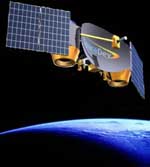
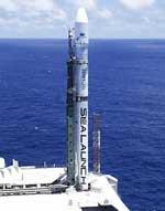
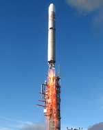
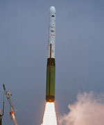
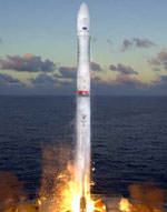
An Indian PSLV rocket blasted off today from the Satish Dhawan Space Center carrying the IRS-P6 remote sensing satellite into an 821 km high polar orbit. The rocket was launched even though the weather was poor with heavy rains ? the wind, however, wasn?t a problem. IRS-P6 is the most advanced remote sensing satellite built by the Indian Space Research Organization (ISRO); it will primarily monitor natural resources, like water, agriculture, and gather land management data.

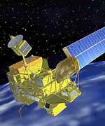
In its eighth flight conducted from Satish Dhawan Space Centre, (SDSC), SHAR, Sriharikota, today (October 17, 2003), ISRO’s Polar Satellite Launch Vehicle, PSLV-C5, successfully launched the Indian remote sensing satellite, RESOURCESAT-1 (IRS-P6) into a 821km high polar Sun Synchronous Orbit (SSO). The 1,360 kg RESOURCESAT-1 is the most advanced and heaviest remote sensing satellite launched by ISRO so far. PSLV forms an important component of the end to end system created by ISRO for natural resource planning and management.

PSLV-C5 lifted off from SDSC, SHAR, Sriharikota at 10:22 am with the ignition of the core first stage and four strap-on motors. The remaining two strap-on motors of the first stage were ignited at 25 sec after lift-off. After going through the planned flight events including the separation of the ground-lit strap-on motors, separation of air-lit strap-on motors and first stage, ignition of the second stage, separation of the payload fairing after the vehicle had cleared the dense atmosphere, second stage separation, third stage ignition, third stage separation, fourth stage ignition and fourth stage cut-off, RESOUCESAT-1 was systematically injected into orbit 1080 seconds after lift-off.

RESOURCESAT-1 was separated after suitable reorientation of the fourth stage-equipment bay combination to avoid any collision with the satellite. RESOURCESAT-1 has been placed in the polar Sun Synchronous Orbit (SSO) at an altitude of 821 km with an inclination of 98.76 deg with respect to the equator.

About PSLV
It may be noted that PSLV was designed and developed by ISRO to place 1,000 kg class Indian remote sensing satellites into polar Sun-synchronous Orbit (SSO). Since its first successful flight in October 1994, the capability of PSLV has been enhanced from 850 kg to the present 1,400 kg into 820 km Sun Synchronous Orbit. PSLV has also demonstrated multiple satellite launch capability. So far, it has launched seven Indian satellites as well as four small satellites for international customers.

The improvement in the payload capability of PSLV over successive flights has been achieved through several means — increase in the propellant loading of the first stage solid propellant motor and second and fourth stage liquid propellant motors, improvement in the performance of the third stage motor by optimizing motor case and enhanced propellant loading and employing a carbon composite payload adapter. The sequence of firing of the strap-on motors has also been changed from two ground-lit and four air-lit to the present four ground-lit and two air-lit sequence.

In the PSLV-C5, the metallic third stage adapter was replaced by the one built with carbon composites. Also, the liquid propellant second stage was operated at a higher chamber pressure for better performance.

In its present configuration, the 44.4 metre tall, 294 tonne PSLV has four stages using solid and liquid propulsion systems alternately. The first stage is one of the largest solid propellant boosters in the world and carries 138 tonne of Hydroxyl Terminated Poly Butadiene (HTPB) propellant. It has a diameter of 2.8 m. The motor case is made of maraging steel. The booster develops a maximum thrust of about 4,762 kN. Six strap-on motors, four of which are ignited on the ground, augment the first stage thrust. Each of these solid propellant strap-on motors carries nine tonne of solid propellant and produces 645 kN thrust.

The second stage employs indigenously built Vikas engine and carries 41.5 tonne of liquid propellant — UH25 as fuel and Nitrogen tetroxide (N2O4) as oxidiser. It generates a maximum thrust of about 800 kN.

The third stage uses 7.6 tonne of HTPB-based solid propellant and produces a maximum thrust of 246 kN. Its motor case is made of polyaramide fibre. The fourth and the terminal stage of PSLV has a twin engine configuration using liquid propellant. With a propellant loading of 2.5 tonne (Mono-methyl hydrazine and Mixed Oxides of Nitrogen), each of these engines generates a maximum thrust of 7.3 kN.

The 3.2 m diameter metallic bulbous payload fairing of PSLV is of isogrid construction and protects the spacecraft during the atmospheric regime of the flight. PSLV employs a large number of stage auxiliary systems for stage separation, payload fairing separation and jettisoning, etc.

PSLV control system includes: a) First stage; Secondary Injection Thrust Vector Control (SITVC) for pitch and yaw, reaction control thrusters for roll b) Second stage; Engine gimbal for pitch and yaw and, hot gas reaction control motor for roll control c) Third stage; flex nozzle for pitch and yaw and PS-4 RCS for roll control and d) Fourth stage; Engine gimbal for pitch, yaw and roll and, on-off RCS for control during the coast phase.

The inertial navigation system in the equipment bay, which is located on top of the fourth stage, guides the vehicle from lift-off to spacecraft injection into orbit. The vehicle is provided with instrumentation to monitor the vehicle performance during the flight. S-band PCM telemetry and C-band transponders cater to this requirement. The tracking system provides real-time information for flight safety and for preliminary orbit determination once the satellite is injected into orbit.

The Vikram Sarabhai Space Centre (VSSC), Thiruvananthapuram, designed and developed PSLV. The ISRO Inertial Systems Unit (IISU) at Thiruvananthapuram developed the inertial systems for the vehicle. The Liquid Propulsion Systems Centre, also at Thiruvananthapuram, developed the liquid propulsion stages for the second and fourth stages of PSLV as well as reaction control systems. The Satish Dhawan Space Centre (SDSC), SHAR processed the solid motors and carried out launch operations. ISTRAC provided telemetry, tracking and command support.

With seven successive successful launches, PSLV has proved itself as a reliable vehicle for launching Indian remote sensing satellites. Besides, it has been used for launching a geo-synchronous satellite, KALPANA-1. ISRO has proposed to use PSLV for India’s first unmanned mission to moon, Chandrayaan-1.

RESOURCESAT-1 carries three cameras as follows:
* A high resolution Linear Imaging Self Scanner (LISS-4) operating in three spectral bands in the Visible and Near Infrared Region (VNIR) with 5.8 metre spatial resolution and steerable up to + 26 deg across track to obtain stereoscopic imagery and achieve five day revisit capability
* A medium resolution LISS-3 operating in three spectral bands in VNIR and one in Short Wave Infrared (SWIR) band with 23.5 metre spatial resolution
* An Advanced Wide Field Sensor (AWiFS) operating in three spectral bands in VNIR and one band in SWIR with 56 metre spatial resolution.

RESOURCESAT-1 also carries a Solid State Recorder with a capacity of 120 Giga Bits to store the images taken by its cameras which can be read out later to the ground stations.

Soon after its injection into orbit, the solar panels on board RESOURCESAT-1 were deployed automatically to generate the necessary electrical power for the satellite. Further operations like three axis stabilisation are being carried out. The satellite health is being continuously monitored from the Spacecraft Control Centre at Bangalore with the help of ISTRAC network of stations at Bangalore, Lucknow, Mauritius, Bearslake in Russia and Biak in Indonesia. Further operations on the satellite like orbit trimming, checking out the various subsystems and, finally, switching on the cameras will be carried out in the coming days.

With ISRO Satellite Centre (ISAC), Bangalore, as the lead Centre, RESOURCESAT-1 was realised with major contributions from Space Applications Centre (SAC), Ahmedabad, Liquid Propulsion Systems Centre (LPSC) at Bangalore, and ISRO Inertial Systems Unit (IISU), Thiruvananthapuram. ISTRAC is responsible for initial and in-orbit operation of RESOURCESAT-1. The National Remote Sensing Agency ‘s (NRSA) Data Reception Station at Shadnagar near Hyderabad receives the data from RESOURCESAT-1.

Once commissioned, RESOURCESAT-1 will not only continue the services of IRS-1C and IRS-1D, but also enhance the remote sensing services by providing imageries with improved spatial resolution and additional spectral bands.

Original Source: ISRO News Release

Four Possible Causes for Contour’s Failure

Image credit: NASA

NASA investigators have come up with four possible reasons why the Comet Nucleus Tour (CONTOUR) mission failed in August 2002. The mission launched in July 2002, and was supposed to visit at least two comets and study their icy nuclei, but something went wrong that caused the spacecraft to disappear from ground tracking stations. The most probably cause of the failure was a structural failure of the spacecraft while its solid rocket motor was firing, but the investigators are also considering a collision with debris, a catastrophic failure of the rocket motor, and loss of the spacecraft?s control systems.

NASA’s Comet Nucleus Tour (CONTOUR) Mishap Investigation Board (MIB) identified four possible causes for the failure of the comet-rendezvous mission launched in July 2002. The Board concluded the probable proximate cause for this accident was structural failure of the spacecraft due to plume heating during the embedded solid-rocket motor burn.

However, the lack of telemetry and observational data, immediately prior to and during the burn, and the lack of recoverable debris, leave open the possibility that one of several other problems could have led to the accident. The alternate possible causes are catastrophic failure of the solid rocket motor; collision with space debris or meteoroids; and loss of dynamic control of the spacecraft.

NASA was not able to re-establish contact with the spacecraft on August 15, 2002, following a propulsive maneuver involving the solid rocket motor. On August 22, 2002, the Associate Administrator for Space Science established the NASA CONTOUR Mishap Investigation Board with Theron Bradley Jr., NASA Chief Engineer, as chair. The purpose of the Board was to examine the processes, data and actions surrounding the events of August 15; to search for proximate and root causes; and develop recommendations that may be applicable to future missions.

Based on various facts and data, the MIB concluded the alternate possible causes were less likely than the identified proximate cause. Nonetheless, in the spirit of constructively improving future mission reliability, the Board drew conclusions, identified lessons learned, and made recommendations based on the broader range of possible causes, according to Bradley.

Launched on July 3, 2002, CONTOUR was intended to encounter at least two comets and perform a variety of investigations and analyses of the comet material. It remained in Earth orbit until August 15, 2002, when an integral Alliant Techsystems STAR? 30BP solid rocket motor was fired to leave orbit and begin the transit to the comet Encke.

CONTOUR was programmed to re-establish telemetry contact with the ground following the burn, however, no signal was received. The mission design did not provide for telemetry coverage during the solid rocket motor burn and no provision was made to optically observe the burn.

Active attempts to contact CONTOUR were unsuccessful. On August 16, 2002, limited ground observations identified what appeared to be three separate objects on slightly divergent trajectories near, but behind, CONTOUR’s expected position. Further attempts to contact CONTOUR were made through December 20, 2002, when NASA and Johns Hopkins University/Applied Physics Laboratory (APL), Laurel, Md., concluded the spacecraft was lost. The project manager at APL oversaw the technical implementation of the project and was responsible for the design, development, test and mission operations.

The MIB established Root Causes and Observations contributing to the failure, and recommendations for each in the Report.

“NASA will apply the lessons from CONTOUR to future missions,” Bradley said. He stated the report represented a lot of tough detective work by the many individuals and organizations involved in the investigation. “The lack of data meant the investigators could leave no stone unturned in their search for possible causes,” he said.

Original Source: NASA News Release

Canada Joins Galileo System

Image credit: ESA

The Canadian Space Agency announced today that it will be contributing to the development of Galileo, the space-based navigation system being created by the European Space Agency – similar to the US Global Positioning System. Canada will contribute $11 million which will open up the development stage of the project to accept bids from Canadian contractors. China announced a similar commitment last month. Galileo is expected to be fully operational by 2008.

Canada’s space industry will directly benefit from an Arrangement signed yesterday between the Canadian Space Agency (CSA) and the European Space Agency (ESA) that ensures Canada’s participation in the Development and Validation Phase of Europe’s Galileo Program.

Galileo is a European satellite navigation and positioning system that will provide highly accurate global positioning services. The CSA’s $11 million contribution to this phase of Galileo allows Canadian companies to respond to requests for proposals and to take an active part in the program.

“By collaborating with ESA in this leading-edge international satellite navigation initiative, Canada is targeting its funding to provide new and exciting opportunities for the Canadian space industry,” said Allan Rock, Minister of Industry and Minister responsible for the CSA.

Galileo is a joint initiative of the European Commission and ESA. It will be the first satellite positioning and navigation system intended specifically for civilian purposes and it will improve the reliability and availability of navigation and positioning services worldwide. When fully deployed in 2008, Galileo will employ up to 30 satellites in medium earth orbit, and will be supported by a worldwide network of ground stations. The Development and Validation Phase will take place from 2003 to 2006.

“Galileo’s new generation of navigation services will also benefit Canadians in such areas as air and sea traffic control, ground transportation, crime prevention, urban planning, agriculture and fisheries,” said Marc Garneau, President of the CSA.

The Arrangement was signed yesterday in Paris by Raymond Chr?tien, Canada’s Ambassador to France, on behalf of the Government of Canada, and by Jean-Jacques Dordain, ESA’s Director General.

About Canada and ESA

The European Space Agency (ESA) is composed of 15 Member States. Canada is a Cooperating Member and the only non-European country to participate directly in earth observation, telecommunications, navigation, exploration and technology development programs of ESA. Under the terms of the Canada-ESA Cooperation Agreement, CSA’s contributions to ESA programs are returned in the form of contracts to Canadian industry. The year 2004 will mark the 25th anniversary of Canada-ESA collaboration.

About the Canadian Space Agency

Established in 1989 with its Headquarters situated in Longueuil, Quebec, the CSA is responsible for the overall national program. The CSA delivers services relating to Earth and the Environment, Space Science, Human Presence in Space, Satellite Communications, Space Technology, Space Qualification Services, Space Awareness and Education. The CSA is at the forefront of the development and application of space knowledge for the benefit of Canadians and humanity.

Original Source: CSA News Release

Orbital Wins Air Force Launch Contract

Image credit: Orbital

Orbital Sciences announced on Thursday that they have been given an $11 million contract by the US Air Force to launch a classified satellite payload on a Minotaur rocket. Three other payloads are currently scheduled to launch on Minotaur rockets, which are rebuilt Minuteman ICBMs for the first and second stages, and then the third and fourth stages are from a Pegasus XL rocket. The launch is scheduled for 2005.

Orbital Sciences Corporation (NYSE: ORB) announced today that the U.S. Air Force has exercised an option order for a Minotaur space launch vehicle under the 10-year Orbital/Suborbital Program-2 (OSP-2) contract that was awarded to the company earlier this year. The Minotaur order is the first to be placed under the OSP-2 contract, which is valued at up to $475 million over 10 years on an indefinite delivery/indefinite quantity basis. The new order increases the launch manifest for the Minotaur program to four missions to be carried out over the next two years. This most recent Minotaur space launch vehicle ordered by the Air Force is scheduled to launch a classified payload in 2005. In addition, Orbital is currently under firm contract to carry out three other Minotaur missions, including N-FIRE and XSS-11, both of which are scheduled to be launched in 2004, and COSMIC, scheduled for launch in 2005.

?We are very pleased to have the opportunity to conduct cost-effective military space missions for the Department of Defense,? said Mr. Ron Grabe, Orbital?s Executive Vice President and General Manager of its Launch Systems Group. ?The Minotaur program represents an efficient use of government assets and commercial technology to provide low-cost, operationally responsive and reliable launch services for U.S. government customers.?

Orbital originally developed the four-stage Minotaur rocket under the Air Force’s OSP-1 contract, which was awarded to the company in 1997. The Minotaur vehicle uses government-supplied Minuteman II rocket motors that serve as the vehicle?s first and second stages. The rocket?s third and fourth stages, as well as its guidance and control system, use technology from Orbital’s highly reliable Pegasus XL commercial rocket program.

Orbital has carried out two previous Minotaur missions, both of which were fully successful. In January 2000, Minotaur made its successful debut with the launch of the JAWSAT spacecraft. Later in 2000, the second Minotaur rocket successfully launched the MightySat-II satellite into low-Earth orbit. Both missions were conducted from launch facilities at Vandenberg Air Force Base (VAFB), CA.

Over the past several years, Orbital has experienced rapid growth in its launch vehicle programs for military space and missile defense-related missions. The company?s launch vehicle business is primarily centered at Orbital?s engineering and production facility in Chandler, AZ, where the company employs approximately 800 people. Orbital also maintains launch vehicle assembly, integration and test facilities at VAFB, where the company employs nearly 100 people.

Original Source: Orbital News Release

Sea Launch Lofts Galaxy XIII/Horizons-1

Image credit: Boeing

Sea Launch successfully launched Boeing-built Galaxy XIII/Horizons-1 satellite from the equator in the Pacific Ocean early this morning. A Zenit-3SL rocket lifted off from the launch platform at 0403 GMT (12:03am EDT) and carried the dual purpose satellite into orbit. A ground tracking station received signals from the satellite about an hour after launch, indicating that it was functioning normally and in the right trajectory to make its journey to geosynchronous orbit. It will eventually provide a variety of telecommunication services to North America.

Last night, a successful launch orbited Galaxy XIII/Horizons-1, a Boeing 601HP satellite built by Boeing [NYSE:BA] for PanAmSat Corporation, Wilton, Conn., and JSAT Corporation of Japan. The satellite will provide coverage over North America, Central America, Alaska and Hawaii from an orbital slot between the Hawaiian Islands and the U.S. west coast.

The 4,090 kg (8,998 lbs) satellite rocketed to geosynchronous transfer orbit aboard a Zenit-3SL provided by Sea Launch Company, LLC. Lift-off occurred at 9:03 p.m. PDT (4:03 a.m. GMT) from the Sea Launch Odyssey Launch Platform positioned on the equator in the Pacific Ocean. The spacecraft received its first signals at about 10:03 p.m. PDT at a ground station at Fucino, Italy, confirming normal operation.

?Communications satellites have erased the distance between the far corners of the globe,? said Dave Ryan, president of Boeing Satellite Systems International, a wholly owned subsidiary of Boeing. ?Galaxy XIII/Horizons-1 will continue that heritage as it also links the aspirations of PanAmSat and JSAT, who will use it to deliver trans-Pacific communications services. We are very proud to continue our legacy of teamwork with these two very important long time customers.?

Galaxy XIII/Horizons-1 with a final orbit slot at 127 degrees west longitude is the 207th Boeing-built commercial communications satellite launched to date. Forty years ago this year, the Boeing-built Syncom ushered in a revolution as the world?s first geosynchronous communications satellite.

Galaxy XIII/Horizons-1 will support PanAmSat?s domestic cable program distribution services as well as the Horizons international joint venture of PanAmSat and JSAT. The spacecraft will carry a total of 48 active transponders, 24 each in Ku-band and C-band. The Horizons partnership will use the spacecraft’s Ku-band payload, known as Horizons-1, to offer a variety of digital video, Internet and data services. In addition, the Ku-band payload on Galaxy XIII/Horizons-1 will be able to deliver content and services between the United States and Asia, using a teleport in Hawaii.

The C-band portion of the new spacecraft, known as Galaxy XIII, will be operated separately as part of PanAmSat’s Galaxy cable neighborhood, which serves the domestic U.S. cable industry. Galaxy XIII will be used to replace capacity on Galaxy IX, a Boeing 376 model that will move to a new orbital position and continue to provide services.

PanAmSat Corporation (NASDAQ:SPOT) is the premier provider of global video and data broadcasting services via satellite. For more information on PanAmSat, visit the company’s web site at www.panamsat.com. JSAT is a leading satellite operator in the Asia-Pacific region. For more information on JSAT, visit the company’s web site at www.jsat.net.

A unit of The Boeing Company, Boeing Integrated Defense Systems is one of the world’s largest space and defense businesses. Headquartered in St. Louis, Boeing IDS is a $25 billion business that provides systems solutions to its global military, government and commercial customers. It is a leading provider of intelligence, surveillance and reconnaissance; the world’s largest military aircraft manufacturer; the world’s largest satellite manufacturer and a leading provider of space-based communications; the primary systems integrator for U.S. missile defense; NASA’s largest contractor; and a global leader in launch services.

Original Source: Boeing News Release

Sea Launch Countdown Begins

Image credit: Boeing

The Sea Launch arrived at the equator in the Pacific Ocean on the weekend, and began the 72-hour countdown to the launch of the Galaxy XIII/Horizons-1 satellite on board a three-stage Zenit-3SL rocket. If all goes well, the rocket will lift off on October 1 at 0403 GMT (12:03am EDT) and carry the satellite to a high perigee geosynchronous transfer orbit. Once it reaches its final destination, the satellite will provide data, television, and voice communication services to North America.

The Sea Launch team arrived at the equatorial launch site this weekend and initiated a 72-hour countdown to liftoff of the Galaxy XIII/Horizons-1 mission for PanAmSat Corporation and JSAT Corporation. All systems are proceeding on schedule for the launch, scheduled for Tuesday, September 30, 9:03 pm PDT (4:03:00 GMT, October 1) at the opening of the 39-minute launch window.

The Odyssey Launch Platform and its sister ship, the Sea Launch Commander, arrived at the launch site on Saturday. The marine crew began the process of ballasting the Launch Platform about 65 feet, to launch depth, in preparation for launch operations. The vessels are now stationed alongside each other, frequently connected by a link bridge that enables foot traffic between them. On the day of launch, the platform will be evacuated and all personnel will be stationed on the ship, three miles uprange, throughout launch operations.

Sea Launch?s three-stage Zenit-3SL rocket will loft the 4,090 kg (9,081 lb) Galaxy XIII/Horizons-1 satellite to a high perigee geosynchronous transfer orbit. Following the successfully completed mission, the spacecraft will be located in geostationary orbit at 127 degrees West Longitude. Built by Boeing Satellite Systems in El Segundo, Calif., the 601 HP model spacecraft is designed to offer a variety of digital video, Internet and data services to North America, Central America, Alaska and Hawaii. Horizons-1 is jointly owned by PanAmSat and JSAT, and supports their Horizons venture. It will provide expanded Ku-band services in North America and extended services to Japan and Asia via a Hawaii-based relay station. The C-band payload, Galaxy XIII, which will be operated independently by PanAmSat, will offer the first high-definition neighborhood in the U.S. cable arc.

Sea Launch will provide a live satellite broadcast and simultaneous webcast of the Galaxy XIII/Horizons-1 mission on September 30, beginning at 8:45pm PDT (3:45:00 GMT, October 1). The broadcast, featuring live video from the launch site as well as commentary, may be downlinked from satellite coordinates posted at the following site:
www.boeing.com/nosearch/sealaunch/broadcast.html
Streaming video of the mission will be carried live at:
www.sea-launch.com/current_index_webcast.html

Original Source: Boeing news release