NASA Tries to Contact Pioneer 10


Image credit: NASA

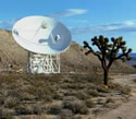
Later this week, NASA scientists will attempt to contact the distant Pioneer 10 spacecraft, which was launched 30 years ago. The team will try to reach the spacecraft by focussing a radio telescope at the Jet Propulsion Laboratory?s Deep Space Network (DSN) in Madrid, Spain. Launched on March 2, 1972, Pioneer 10 is now 11.9 billion kilometres away from the Earth and hasn’t been heard from since April 2001.

NASA scientists will try to contact Pioneer 10 this week to see if the plucky little spacecraft?s signal can still be heard ? 30 years after its launch.

On March 2, 2002, scientists operating a radio telescope at the Jet Propulsion Laboratory?s Deep Space Network (DSN) in Madrid, Spain, will attempt to duplicate the feat they accomplished last spring, when they successfully established contact with the spacecraft after a silence of eight months.

“We?re going to try again this year to see if Pioneer 10 still lives on,” said Pioneer 10 Flight Director David Lozier of NASA Ames Research Center, located in the heart of California?s Silicon Valley. “We are hopeful that the successful contacts with the spacecraft that we had last year will be repeated this year.”

NASA made contact with the spacecraft in April of last year. It was the first time the spacecraft had been heard from since the previous summer.

“We had been listening for the Pioneer 10 signal with no success,” recalled Pioneer 10 Project Manager Dr. Larry Lasher of Ames. “So we felt that in order for Pioneer 10 to talk to us, we might need to talk to it.

“We sent up a signal on April 27, 2001, and on April 28, 2001 – 22 hours later, the time it took for the two-way signal to return ? there it was, right on time; it came in loud and clear and strong,” said Lasher. Since then, the scientists have successfully contacted the spacecraft twice more, most recently on July 9, 2001.

Launched on March 2, 1972, Pioneer 10, built by TRW Inc., Redondo Beach, Calif., is now at a distance of 7.4 billion miles from Earth. Pioneer 10 was the first spacecraft to pass through the asteroid belt and the first to make direct observations and obtain close-up images of Jupiter. During the passage by Jupiter, Pioneer 10 also charted Jupiter?s intense radiation belts, located the planet?s magnetic field, and established that Jupiter is predominantly a liquid planet.

In 1983, it became the first man-made object to leave the solar system when it passed the orbit of the most distant planet. The spacecraft continued to make valuable scientific investigations in the outer regions of the solar system until its science mission ended on March 31, 1997. Pioneer 10?s weak signal continues to be tracked by DSN as part of an advanced concept study of communications technology. Pioneer 10 is headed toward the constellation Taurus (the Bull), where it will pass the nearest star in the constellation in about two million years.

“Pioneer 10 has performed much better than expected,” said Robert Hogan, chief of Ames? Space Projects Division where the Pioneer project is managed. “It?s amazing that it?s lasted this long,” added Hogan, who is also a member of the original launch team for the spacecraft.

Scientists continue to analyze data received from Pioneer 10?s Geiger-Tube Telescope instrument operated by principal investigator Dr. James Van Allen of the University of Iowa. Based on the data received, Van Allen concluded that cosmic-ray intensity has continued to decrease. According to Van Allen, Pioneer 10 is still under the delayed influence of solar activity and has not yet reached the cosmic ray modulation boundary of the heliosphere. Scientists say knowledge of this boundary will help define the edge of the solar system, the location where the outermost boundary of the solar system meets interstellar space.

Original Source: NASA News Release

Quikscat Satellite Goes Operational


Weather forecasters have added wind speed and direction data from NASA’s Quick Scatterometer spacecraft (Quikscat) to help them predict violent storms as much as 6-12 hours before they happen. Launched almost three years ago, the Quikscat takes approximately 400,000 measurements every day, comprising 93% of the Earth’s surface. The spacecraft has proven its ability to improve forecasts of hurricanes, so several International weather agencies have decided to assimilate its data into their predictions.

In a move to improve global weather forecasts and ultimately save lives and property, the United States and Europe have incorporated wind speed and direction data from NASA’s Quick Scatterometer spacecraft-also known as Quikscat-into their operational global weather analysis and forecast systems.

Armed with data from Quikscat, forecasters can now predict hazardous weather events over the oceans as much as six to 12 hours earlier. Launched June 19, 1999, the Quikscat spacecraft operates in a Sun-synchronous, 800-kilometer (497-mile) near-polar orbit, circling Earth every 100 minutes, taking approximately 400,000 measurements over 93 percent of Earth’s surface every day.

In recent years, data from the Quikscat scatterometer, developed by NASA’s Jet Propulsion Laboratory, Pasadena, Calif., have proven useful in improving forecasts of extreme wind events, such as hurricanes, and in monitoring longer-term climatic effects such as El Nino. Quikscat’s SeaWinds scatterometer instrument is a specialized microwave radar that continuously measures both the speed and direction of winds near the ocean surface in all weather conditions.

Participants in the Quikscat program include the National Centers for Environmental Prediction, a branch of the National Weather Service, Washington, D.C., and the European Centre for Medium-Range Weather Forecasts, Reading, England. These organizations’ decision to assimilate and turn Quikscat data into operational information culminates an intense inter-agency and international cooperative effort among NASA, the National Oceanic and Atmospheric Administration (NOAA) and European countries to demonstrate and validate Quikscat’s potential impact on weather forecasting.

“Our implementation of Quikscat data has provided another useful data source for improved surface wind forecasts,” said Stephen Lord, director of the National Centers for Environmental Prediction’s Environmental Modeling Center, which developed the Quikscat data processing in collaboration with NASA and NOAA Satellite Service.

“The use of Quikscat data to improve weather forecasts underscores the value of the mission beyond the scientific research community,” said Dr. Michael Freilich, Quikscat principal investigator and a professor at Oregon State University, Corvallis. “Realizing the full potential of Quikscat data is possible only because of a series of unique collaborations. NASA researchers and engineers worked together to develop and calibrate the instrument and algorithms. NOAA personnel, in partnership with NASA, enable rapid delivery of near-real-time spacecraft data to forecast centers. There also are the teams of meteorologists who are developing and refining computer programs that incorporate the data into models and display measurements for forecasters.”

Helen Wood, director of NOAA’s Office of Satellite Data Processing and Distribution, said Quikscat data would positively impact NOAA’s weather forecasting and storm warnings. “Quikscat data will help our forecasters more accurately determine the paths and intensities of severe winter storms, tropical storms and hurricanes, which saves lives and property,” she said. “The data are also used by climate change researchers and commercial shipping interests.”

The incorporation of Quikscat data was one of several recent upgrades made to the European Centre for Medium-Range Weather Forecasts’ operational system. Cumulatively, the upgrades have resulted in a robust improvement in forecasts of atmospheric conditions over the Southern Hemisphere and in the upper atmosphere. Their ability to forecast tropical cyclone tracks has also been enhanced.

JPL manages Quikscat for NASA’s Office of Earth Science, Washington, D.C. JPL also built the scatterometer instrument and provides ground science processing systems. NASA’s Goddard Space Flight Center, Greenbelt, Md., managed development of the satellite, designed and built by Ball Aerospace & Technologies Corp., Boulder, Colo.

Original Source: NASA News Release

Odyssey Mapping Mission Begins

After months of orbital manoeuvres, the Mars Odyssey spacecraft is ready to get to work searching for water on the surface of Mars. NASA flight controllers instructed the spacecraft to turn its scientific equipment towards the Red Planet on Monday. Operators expect it will take a few days to fully calibrate the equipment, and hope to release the first images to the public on March 1.

Odyssey Deploys Communications Antenna

NASA’s Mars Odyssey spacecraft deployed its high-gain antenna on Tuesday night, establishing a high-speed connection between the spacecraft and controllers back on Earth. Flight controllers tested the boom to ensure it can communicate with different locations on Earth and then pronounced the deployment “successful”. Science instruments on the spacecraft are expected to begin collecting data later this month.

Odyssey Reaches Final Mapping Orbit

NASA?s Mars Odyssey spacecraft has reached its final mapping orbit after three months of aerobraking manoeuvres around the Red Planet. At 2014 GMT (5:14pm EST) Odyssey fired its thrusters for 25 seconds and decreased its velocity to maintain an orbit which varies between 387km and 450km above the surface of Mars. Two scientific instruments on the spacecraft have already begun collecting data about the composition of the planet?s surface.

EUVE Expected to Enter the Earth’s Atmosphere Shortly

The Extreme Ultraviolet Explorer (EUVE) spacecraft is expected to re-enter the Earth?s atmosphere sometime on Thursday morning. Although they don?t know where or when it will crash – as far South as Brisbane, Australia, and as far North as Orlando, Florida – NASA believes that most of the spacecraft will be destroyed on re-entry with some pieces crashing into the ocean. Unlike many large spacecraft, the EUVE wasn?t built with a propulsion system to control its crash location. During its eight years in orbit, the EUVE observed over 1,000 objects in the extreme ultraviolet spectrum.