Give Mom the Aurora Tonight / Mercury Transit Update

A coronal aurora twists overhead in this photo taken early on May 8 from near Duluth, Minn. Credit: Bob King
Skywatchers across the northern tier of states, the Midwest and southern Canada were treated to a spectacular display of the aurora borealis last night. More may be on tap for tonight. Credit: Bob King
Skywatchers across the northern tier of states, the Midwest and southern Canada were treated to a spectacular display of the aurora borealis last night. More may be on tap for tonight — in honor of Mother’s Day of course! Credit: Bob King

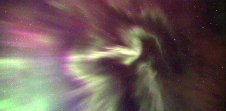
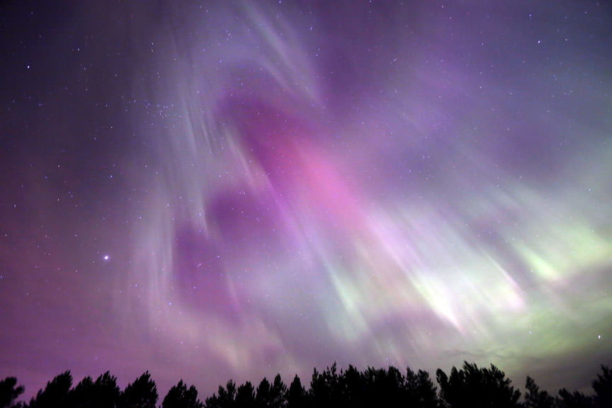
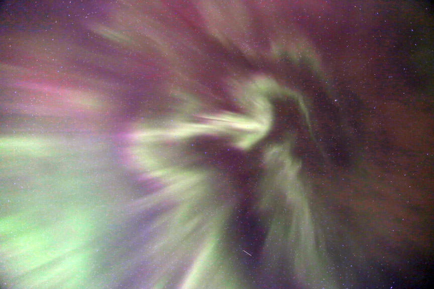
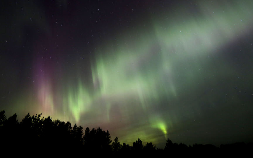
Simple choices can sometimes lead to dramatic turns of events in our lives. Before turning in for the night last night, I opened the front door for one last look at the night sky. A brighter-than-normal auroral arc arched over the northern horizon. Although no geomagnetic activity had been forecast, there was something about that arc that hinted of possibility.

It was 11:30 at the time, and it would have been easy to go to bed, but I figured one quick drive north for a better look couldn’t hurt. Ten minutes later the sky exploded. The arc subdivided into individual pillars of light that stretched by degrees until they reached the zenith and beyond. Rhythmic ripples of light – much like the regular beat of waves on a beach — pulsed upward through the display. You can’t see a chill going up your spine, but if you could, this is what it would look like.

A coronal aurora twists overhead in this photo taken early on May 8 from near Duluth, Minn. Credit: Bob King
A coronal aurora twists overhead in this photo taken around 12:15 a.m. on May 8 from near Duluth, Minn. What this photo and the others don’t show is how fast parts of the display flashed and flickered. Shapes would form, disappear and reform in seconds. Credit: Bob King

Auroras can be caused by huge eruptions of subatomic particles from the Sun’s corona called CMEs or coronal mass ejections, but they can also be sparked by holes in the solar magnetic canopy. Coronal holes show up as blank regions in photos of the Sun taken in far ultraviolet and X-ray light. Bright magnetic loops restrain the constant leakage of electrons and protons from the Sun called the solar wind. But holes allow these particles to fly away into space at high speed. Last night’s aurora traces its origin back to one of these holes.

Visualization of the solar wind encountering Earth's magnetic "defenses" known as the magnetosphere. Clouds of southward-pointing plasma are able to peel back layers of the Sun-facing bubble and stack them into layers on the planet's nightside (center, right). The layers can be squeezed tightly enough to reconnect and deliver solar electrons (yellow sparkles) directly into the upper atmosphere to create the aurora. Credit: JPL
Both a bar magnet (left) and Earth are surrounded by magnetic fields with north and south poles. Earth’s field is shaped by charged particles – electrons and protons – flowing from the sun called the solar wind. Credit: Andy Washnik (left) and NASA

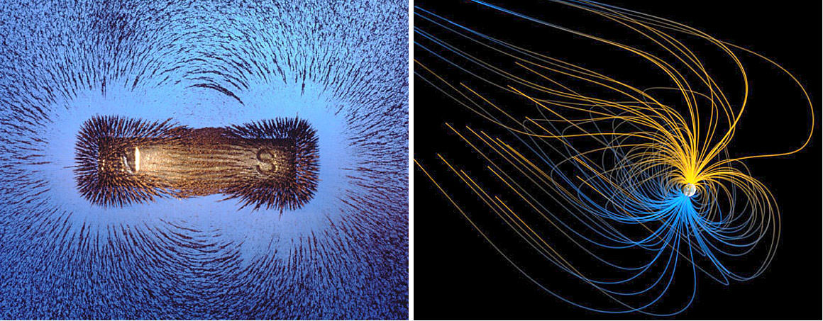
The subatomic particles in the gusty wind come bundled with their own magnetic field with a plus or positive pole and a minus or negative pole. Recall that an ordinary bar magnet also  has a “+” and “-” pole, and that like poles repel and opposite poles attract. Earth likewise has magnetic poles which anchor a large bubble of magnetism around the planet called the magnetosphere.

Visualization of the solar wind encountering Earth's magnetic "defenses" known as the magnetosphere. Clouds of southward-pointing plasma are able to peel back layers of the Sun-facing bubble and stack them into layers on the planet's nightside (center, right). The layers can be squeezed tightly enough to reconnect and deliver solar electrons (yellow sparkles) directly into the upper atmosphere to create the aurora. Credit: JPL
Visualization of the solar wind encountering Earth’s magnetic “defenses” known as the magnetosphere. Clouds of southward-pointing plasma are able to peel back layers of the Sun-facing bubble and stack them into layers on the planet’s nightside (center, right). The layers can be squeezed tightly enough to reconnect and deliver solar electrons (yellow sparkles) directly into the upper atmosphere to create the aurora. Credit: JPL

Field lines in the magnetosphere — those invisible lines of magnetic force around every magnet — point toward the north pole. When the field lines in the solar wind also point north, there’s little interaction between the two, almost like two magnets repelling one another. But if the cloud’s lines of magnetic force point south, they can link directly into Earth’s magnetic field like two magnets snapping together. Particles, primarily electrons, stream willy-nilly at high speed down Earth’s magnetic field lines like a zillion firefighters zipping down fire poles.  They crash directly into molecules and atoms of oxygen and nitrogen around 60-100 miles overhead, which absorb the energy and then release it moments later in bursts of green and red light.

View of the eastern sky during the peak of this morning's aurora. Credit: Bob King
View of the eastern sky during the peak of this morning’s aurora. Credit: Bob King

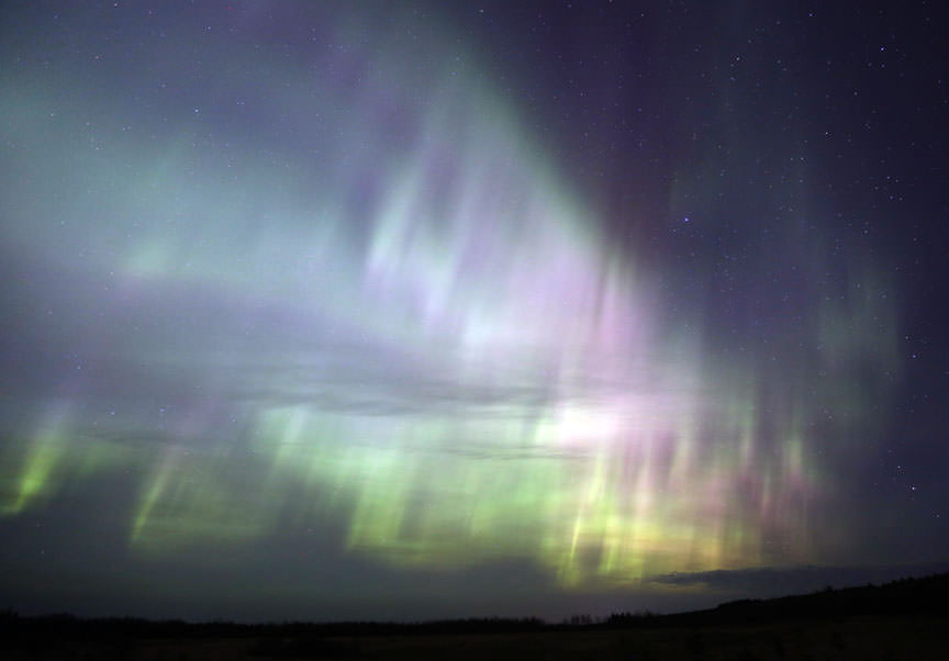
So do great forces act on the tiniest of things to produce a vibrant display of northern lights. Last night’s show began at nightfall and lasted into dawn. Good news! The latest forecast calls for another round of aurora tonight from about 7 p.m. to 1 a.m. CDT (0-6 hours UT). Only minor G1 storming (K index =5) is expected, but that was last night’s expectation, too. Like the weather, the aurora can be tricky to pin down. Instead of a G1, we got a G3 or strong storm. No one’s complaining.

So if you’re looking for that perfect last minute Mother’s Day gift, take your mom to a place with a good view of the northern sky and start looking at the end of dusk for activity. Displays often begin with a low, “quiet” arc and amp up from there.

The camera recorded pale purple and red but the primary color visible to the eye was green. Credit: Bob Kin
The camera recorded pale purple, red and green, but the primary color visible to the eye was green. Cameras capture far more color than what the naked eye sees because even faint colors increase in intensity during a time exposure. Details: ISO 800, f/2.8, 13 seconds. Credit: Bob King

Aurora or not, tomorrow features a big event many of us have anticipated for years — the transit of Mercury. You’ll find everything you’ll need to know in this earlier story, but to recap, Mercury will cross directly in front of the Sun during the late morning-early evening for European observers and from around sunrise (or before) through late morning-early afternoon for skywatchers in the Americas. Because the planet is tiny and the Sun deadly bright, you’ll need a small telescope capped with a safe solar filter to watch the event. Remember, never look directly at the Sun at any time.

Nov. 15, 1999 transit of Mercury photographed in UV light by the TRACE satellite. Credit: NASA

If you’re greeted with cloudy skies or live where the transit can’t be seen, be sure to check out astronomer Gianluca Masi’s live stream of the event. He’ll hook you up starting at 11:00 UT (6 a.m. CDT) tomorrow.

The table below includes the times across the major time zones in the continental U.S. for Monday May 9:

Time Zone Eastern (EDT) Central (CDT) Mountain (MDT) Pacific (PDT)
Transit start 7:12 a.m. 6:12 a.m. 5:12 a.m. Not visible
Mid-transit 10:57 a.m. 9:57 a.m. 8:57 a.m. 7:57 a.m.
Transit end 2:42 p.m. 1:42 p.m. 12:42 p.m. 11:42 a.m.

Countdown Begins for Blastoff of ExoMars 2016 Spacecraft on March 14 – Watch Live

Proton rocket and ExoMars 2016 spacecraft rolled out to launch pad at the Baikonur cosmodrome, Kazakhstan Copyright: ESA - B. Bethge
Proton rocket and ExoMars 2016 spacecraft rolled out to launch pad at the Baikonur cosmodrome, Kazakhstan
Copyright: ESA – B. Bethge

The countdown has begun for blastoff of the ambitious European/Russian ExoMars 2016 spacecraft from the Baikonur Cosmodrome in Kazakhstan on March 14. Its goal is to search for minute signatures of methane gas that could possibly be an indication of life or of nonbiologic geologic processes ongoing today.

Final launch preparations are now in progress. Liftoff of the powerful Russian Proton booster from Baikonur carrying the ExoMars spacecraft is slated for 5:31:42 a.m. EDT (0931:42 GMT), Monday morning, March 14.

You can watch the launch live courtesy of a European Space Agency (ESA) webcast:

http://www.esa.int/Our_Activities/Space_Science/ExoMars/Watch_ExoMars_launch

The prelaunch play by play begins with live streaming at 4:30 a.m. EDT (08:30 GMT).

The first acquisition of signal from the spacecrft is expected at 21:29 GMT

As launch and post launch events unfold leading to spacecraft separation, ESA plans additional live streaming events at 7:00 a.m. EDT (11:00 GMT) and 5:10 p.m. (21:10 GMT)

Spacecraft separation from the Breeze upper stage is expected at about 10 hours, 41 minutes.

Artists concept of ExoMars spacecraft separation from Breeze fourth stage. Credit: ESA

The ExoMars 2016 mission is comprised of a pair of European spacecraft named the Trace Gas Orbiter (TGO) and the Schiaparelli entry, descent and landing demonstration lander, built and funded by the European Space Agency (ESA).

Russian is providing the Proton booster and part of the science instrument package.

“The main objectives of this mission are to search for evidence of methane and other trace atmospheric gases that could be signatures of active biological or geological processes and to test key technologies in preparation for ESA’s contribution to subsequent missions to Mars,” says ESA.

Proton rocket and ExoMars 2016 spacecraft stand vertical at the launch pad at the Baikonur cosmodrome, Kazakhstan Copyright: ESA - B. Bethge
Proton rocket and ExoMars 2016 spacecraft stand vertical at the launch pad at the Baikonur cosmodrome, Kazakhstan
Copyright: ESA – B. Bethge

ExoMars is Earth’s lone mission to the Red Planet following the two year postponement of NASA’s InSight lander from 2016 to 2018 to allow time to fix a defective French-built seismometer.

ESA reported late today , March 13, that at T-minus 12 hours the Trace Gas Orbiter has been successfully switch on, a telemetry link was established and the spacecrft battery charging has been completed.

The Proton rocket with the encapsulated spacecraft bolted atop were rolled out to the Baikonur launch pad on Friday, March 11 and the launcher was raised into the vertical position.

ESA mission controller then completed a full launch dress rehearsal on Saturday, March 12.

The ExoMars 2016 TGO orbiter is equipped with a payload of four science instruments supplied by European and Russian scientists. It will investigate the source and precisely measure the quantity of the methane and other trace gases.

The ExoMars 2016 spacecraft composite, comprised of the Trace Gas Orbiter and Schiaparelli, seen during the encapsulation within the launcher fairing  at the Baikonur cosmodrome in Kazakhstan. Launch to Mars is slated for March 14, 2016.  Copyright: ESA - B. Bethge
The ExoMars 2016 spacecraft composite, comprised of the Trace Gas Orbiter and Schiaparelli, seen during the encapsulation within the launcher fairing at the Baikonur cosmodrome in Kazakhstan. Launch to Mars is slated for March 14, 2016. Copyright: ESA – B. Bethge

Stay tuned here for Ken’s continuing Earth and planetary science and human spaceflight news.

Ken Kremer

SpaceX Aims for Friday Sunset Launch After Boats and Winds Delay Falcon 9 Liftoff and Landing Attempt – Live Webcast

Sunset view of SpaceX Falcon 9 after aborted launch of SES-9 communications satellite on Feb 28, 2016. Liffoff now slated for March 4, 2016 from Pad 40 at Cape Canaveral, FL after four scrubs due to weather and technical issues. Credit: Ken Kremer/kenkremer.com
Sunset view of SpaceX Falcon 9 after aborted launch of SES-9 communications satellite on Feb 28, 2016.  Liffoff now slated for March 4, 2016 from Pad 40 at Cape Canaveral, FL after four scrubs due to weather and technical issues. Credit: Ken Kremer/kenkremer.com
Sunset view of SpaceX Falcon 9 after aborted launch of SES-9 communications satellite on Feb 28, 2016. Liffoff now slated for March 4, 2016 from Pad 40 at Cape Canaveral, FL after four scrubs due to weather and technical issues. Credit: Ken Kremer/kenkremer.com

CAPE CANAVERAL AIR FORCE STATION, FL – Alas SpaceX is now targeting Friday March 4 for the 5th attempt to launch their upgraded Falcon 9 carrying the powerful SES-9 commercial telecommunications satellite, following another pair of launch scrubs earlier this week due to errant boats and strong winds aloft.

“We’re now targeting Friday, March 4 at 6:35 pm ET for launch of SES-9,” said SpaceX spokesman Phil Larson. Sunset is at 6:25 pm. Continue reading “SpaceX Aims for Friday Sunset Launch After Boats and Winds Delay Falcon 9 Liftoff and Landing Attempt – Live Webcast”

Spectacular Blastoff of Atlas Cygnus Ignites Restart of American Cargo Missions to ISS

Orbital ATK’s Cygnus Spacecraft carrying vital cargo to resupply the International Space Station lifts-off aboard a United Launch Alliance Atlas V rocket on Dec. 6, 2015. Credit: Ken Kremer/kenkremer.com
Orbital ATK’s Cygnus Spacecraft carrying vital cargo to resupply the International Space Station lifts-off aboard a United Launch Alliance Atlas V rocket.  Credit: Ken Kremer/kenkremer.com
Orbital ATK’s Cygnus Spacecraft carrying vital cargo to resupply the International Space Station lifts-off aboard a United Launch Alliance Atlas V rocket. Credit: Ken Kremer/kenkremer.com
Story/photos updated

KENNEDY SPACE CENTER, FL – Today’s spectacular blastoff of a United Launch Alliance Atlas V rocket carrying an Orbital ATK Cygnus commercial resupply spacecraft ignited the restart of critically needed American cargo mission to the International Space Station (ISS) following a pair of launch failures over the past year.

The ULA Atlas V rocket roared off the launch pad at 4:44 p.m. EST at the opening of a 30 minute launch window from Space Launch Complex 41 at Cape Canaveral Air Force Station in Florida. Continue reading “Spectacular Blastoff of Atlas Cygnus Ignites Restart of American Cargo Missions to ISS”

Tonight’s the Night! Maps to Help You Spot Asteroid TB145

Map showing TB145's position for an observer in the north central U.S. at 15-minute intervals starting at 5:00 UT. Subtract 4 hours from UT for EDT, 5 hours for CDT, 6 for MDT and 7 for PDT. Stars are shown to magnitude +12 and north is up. Credit: Chris Marriott's SkyMap


This simulation by Tom Ruen shows the trajectory of 2015 TB145 across the sky, showing tracer spheres spaced at one hour intervals along its path.

Halloween fireballs, a Supermoon and now a near-Earth asteroid flyby. What a week! While 2015 TB145 won’t be visible in binoculars because of its relative faintness and glare from a nearby waning gibbous Moon, you should be able to see it in an 8-inch telescope or larger telescope without too much difficulty.

Determined amateurs might even catch it in instruments as small as 4.5 inches  especially tomorrow morning when the fleeing space mountain will brighten to around magnitude +10.

For western hemisphere observers, TB145 begins the evening in Orion’s Shield not far below the Hyades Cluster looking like a magnitude +11.5 star crawling northeast through the star field. By dawn on Halloween, it will top out around magnitude +10.2 as it zips through Taurus and Auriga traveling around 3-5° per hour depending on the time you look. For most of the night, TB145 will move swiftly enough to notice its motion in real time, resembling an Earth-orbiting satellite. Closest approach occurs around 17:00 UT (noon CDT) when it pass along bottom of the Big Dipper Bowl at around 10° hour. Amazing!

Map showing the asteroid's progress across the horns of Taurus from 9-10:45 UT October 31st. It passes about 1.5 northwest of the Crab Nebula around 5:30 UT. Credit: Chris Marriott's SkyMap
Map showing the asteroid’s progress across the horns of Taurus from 9-10:45 UT (4 – 5:45 a.m.) October 31st. It passes about 1° northwest of the Crab Nebula around 10:30 UT. Credit: Chris Marriott’s SkyMap

My hope is that these maps will help you spot and follow this zippy, aircraft carrier-sized boulder. Three of the four maps cover most of the time between 5:00 and 11:45 UT, equivalent to midnight CDT tonight to 6:45 a.m. tomorrow morning. I used the very latest orbital elements and hand plotted the positions (a tedious exercise but worth it!) at 15-minute intervals. For convenience, when you print them out, I’d suggest using a straight edge to draw a line connecting the position dots.

As we discussed in the previous Universe Today storyparallax comes into play when viewing any nearby Solar System object. Three of the maps show the asteroid’s position from the North Central U.S. One depicts the view from the South Central U.S. from 11-11:45 UT. Parallax is minor early on from midnight to 2 or 3 a.m. but becomes more significant near closest approach. This is based on comparisons I made between latitudes 47°-32° North.

By this time, TB145 will be around magnitude +10.4 and easier to see than at the start our run. The map covers the time from 11-11:4 5 UT (6 - 6:45 a.m. CDT). Credit: Chris Marriott's SkyMap
By this time, TB145 will be around magnitude +10.4 and easier to see than at the start our run. The map covers the time from 11-11:45 UT (6 – 6:45 a.m. CDT). Credit: Chris Marriott’s SkyMap

I apologize for the limited number of maps in this article but hope these and the do-it-yourself approach described in the earlier article will be enough to set you on TB145’s trail.

The view from the southern U.S. (about 32 latitude). Compared to the northern U.S., the asteroid's path lies about 5 arc minutes to the north. Credit: Chris Marriott's SkyMap
The view from the southern U.S. (about 32° latitude) from 11-11:45 UT. Compared to the northern U.S., the asteroid’s path lies about 5 arc minutes further to the north. Credit: Chris Marriott’s SkyMap

As always when trying to spot asteroids on the move, pick a time and camp out at that spot with your telescope five minutes before the expected arrival time. Take the time to casually memorize the star patterns, so when the interloper arrives, you’ll pick it out straightaway. Again, depending on your location both east-west and north-south of the paths charted, TB145 may arrive a couple minutes earlier or later, but once you spot it, hold on tight. You’ll be going on a most exciting ride!

Map showing TB145's approximate path starting at 4 hours UT on Oct. 31 (11 p.m. CDT Oct. 30). This view faces east. Tick marks show its hourly position. This map provides context for the detailed maps above. Credit: Chris Marriott's SkyMap
Map showing TB145’s approximate path starting at 4 hours UT on Oct. 31 (11 p.m. CDT Oct. 30). This view faces east. Tick marks show its hourly position. This map provides context for the detailed maps above. Credit: Chris Marriott’s SkyMap

We’d love to hear from you whether or not you were successful seeing it. If the weather’s uncooperative or you don’t have a telescope,  Gianluca Masi’s got your back. He’ll webcast the flyby live on his Virtual Telescope site starting at 7 p.m. CDT (0:00 UT) tonight Oct. 30-31.


Now let’s see the flyby of Earth from the asteroid’s point of view, also by Tom Ruen. Enjoy!

How to See the Spooktacular Halloween Flyby of Asteroid 2015 TB145

Map showing TB145's approximate path starting at 4 hours UT on Oct. 31 (11 p.m. CDT Oct. 30). This view faces east. Tick marks show its hourly position. This map provides context for the detailed maps above. Credit: Chris Marriott's SkyMap

Trick or treat! I think we’re definitely in for a treat.  2015 TB145  will fly past Earth at a safe distance slightly farther than the moon’s orbit on Oct. 31 at 12:05 p.m. CDT (17:05 UT). Estimated at 1,300 feet (400-meters) across, this Great Pumpkin of an asteroid will be big enough and close enough to show in small telescopes.

Do I hear the doorbell ringing already?

Shining faintly at 18th magnitude on October 22, 2015 TB145 is already under study by amateur and professional astronomers. Its close approach will make for an excellent opportunity to learn a great deal about its surface properties and orbit. Watch for it to brighten up to magnitude +10.1 at peak, bright enough to see in a 4.5-inch telescope. Credit: Gianluca Masi

UPDATE Oct. 30th — I’ve created several detailed maps to help you track TB145.

The close approach of such of TB145 will make for great science opportunities, too. Several optical observatories and the radar capabilities of the agency’s Deep Space Network at Goldstone, California will be tracking this flying mountain as will many amateur astronomers. The 110-foot (34-meter) Goldstone antenna will ping the asteroid with radio waves; the returning echoes will be collected by dishes in West Virginia and Puerto Rico and used to construct images showing the object’s surface features, shape and dimensions. NASA scientists hope to obtain radar images of the asteroid as fine as about 7 feet (2 meters) per pixel.

“The close approach of 2015 TB145 at about 1.3 times the distance of the moon’s orbit, coupled with its size, suggests it will be one of the best asteroids for radar imaging we’ll see for several years,” said Lance Benner, of JPL, who leads NASA’s asteroid radar research program. “We plan to test a new capability to obtain radar images with two-meter resolution for the first time and hope to see unprecedented levels of detail.”

View of the orbit of asteroid 2015 TB145. Its orbit is inclined about 39° to the plane of the Solar System. Credit: P. Chodas (NASA/JPL - Caltech)
View of the orbit of asteroid 2015 TB145. Its orbit is inclined about 39° to the plane of the Solar System. Credit: P. Chodas (NASA/JPL – Caltech)

Astronomers first nabbed asteroid 2015 TB145 on Oct. 10, 2015, using the University of Hawaii’s Pan-STARRS-1 (Panoramic Survey Telescope and Rapid Response System) telescope atop Mt. Haleakala in Maui. According to the catalog of near-Earth objects kept by the Minor Planet Center, this is the closest currently known approach by an object this large until asteroid 1999 AN10 (about 2,600 feet  or 800-m in size) zips by at about 1 lunar distance in August 2027.

The gravitational influence of the asteroid is so small it will have no detectable effect on the Moon or anything here on Earth, including our planet’s tides or tectonic plates. But the planet will certainly have an effect on the asteroid. Earth’s gravity will deflect TB145’s path during the close approach, making it tricky this far out to create an accurate map of its flight across the sky. That’s why the two maps I’ve included with this article are only approximate. As we get closer to Halloween, further refinements in the asteroid’s orbit will allow for more accurate path-making.

TB145's path starting at 4 hours UT on Oct. 31 (11 p.m. CDT Oct. 30). This view faces east. Tick marks show its hourly position. At the start of the path, the asteroid will shine around magnitude 11.4 but will gradually brighten through the night. Credit: Chris Marriott's SkyMap
TB145’s path starting at 4 hours UT on Oct. 31 (11 p.m. CDT Oct. 30). This view faces east. Tick marks show its hourly position. At the start of the path, the asteroid will shine around magnitude 11.4 but will gradually brighten through the night. To convert from UT, subtract 4 hours for EDT, 5 for CDT, 6 for MDT and 7 for PDT. Click for a large version. Credit: Chris Marriott’s SkyMap

Because the asteroid passes so near Earth, parallax will shift its path north or south up to 1/2°. Parallax is the apparent shift in an object’s position against the more distant background stars depending on the observer’s location on Earth. You can see how parallax works using your eyes and a finger. Stick your arm straight out in front of you and hold up your index finger. Open and close your right and then your left eye in a back and forth blinking pattern and watch your finger jump back and forth across the more distant background. Each eye sees the thumb from a slightly different perspective, causing it to shift position against the distant scene.

This is a graphic depicting the orbit of asteroid 2015 TB145. The asteroid will safely fly past Earth sli ghtly farther out than the moon's orbit on Oct. 31 at 10:05 a.m. Pacific (1:05 p.m. EDT and 17:05 UTC). Image credit: P. Chodas (NASA/JPL - Caltech)
Graphic depicting the orbit of asteroid 2015 TB145. The asteroid will safely fly past Earth slightly farther out than the moon’s orbit on Halloween. Credit: P. Chodas (NASA/JPL – Caltech)

This happens all the time with the Moon. You might see it conjunct with a bright planet where skywatchers on the opposite side of the planet see an occultation. That’s why it’s best to make your own map of TB145’s wild ride across the sky. When closest to Earth, the asteroid will cover a Full Moon diameter about every 3 minutes as it tears by us at 22 miles per second (35 km/sec). Without a good map, it’ll get away from you.

Method #1: Using Stellarium

Download the free sky-plotting program Stellarium. Once you’ve set your location, either hit F2 or click on the Configuration icon in the lower left corner of your screen. Now select the Plugins tab then Solar System Editor. Click on Configure at the bottom of the tab, choose Solar System and click Import orbital elements in MPC format.

Next, select the Asteroids option and then from the bookmarks list, choose MPCORB: near-Earth asteroids (NEAs) and then Get orbital elements. Allow the list — a very large one — to load then scroll through it until you find 2015 TD145 and put a check mark in the box. Then click Add objects.

Stellarium view of the sky and featured asteroid seen from northern, Minnesota at 11:55 p.m. October 30, 2015.
Stellarium view of the sky and featured asteroid seen from northern, Minnesota at 11:55 p.m. October 30, 2015. Notice that a bright, waning gibbous Moon will be nearby during the best viewing opportunities for the Americas, which will make 2015 TB145 a little harder to spot.

Still with me? OK, close the Solar System editor and press F3 or select the magnifying glass icon in the lower left corner of your screen, then type in the asteroid’s name exactly as 2015 TD145. Hit enter and you’ll see a set of rotating red crosshairs. Bingo! This where the asteroid will be at the time you chose.  You can adjust your magnitude range, field of view and even download additional files of fainter stars and deep sky objects. Unfortunately, Stellarium can’t draw an arc showing TB145’s changing position with time. Cross your fingers that appears in the next iteration.

Method #2: Download up-to-date orbital elements into your sky-charting program

2015 TB145 belongs to the Apollo family of asteroids, whose orbits cross that of Earth. Amor asteroids approach but don't cross, while Atens also cross Earth's path but spend most of their time inside our orbit. Credit: ESA
2015 TB145 belongs to the Apollo family of asteroids, whose orbits cross that of Earth. Amor asteroids approach but don’t cross, while Atens also cross Earth’s path but spend most of their time inside our orbit. Credit: ESA

Let’s say you already have a sky-charting program like Guide, Dance of the Planets, MegaStar or Starry Night. Go to the Minor Planet &Comet Ephemeris Service and type in 2015 TB145 in the big, blank box. Next, scroll down and select your program from the list and click on Get Ephemerides/HTML page. Save the file of orbital elements that pops up and place into the appropriate folder in your program. Open your program, select 2015 TB145 and make a chart!

Method #3: Manually input orbital elements into your program

You can also go to JPL’s Horizons site for the very latest orbital elements you can manually input in your program. 2015 TB145 is expected to be as bright as magnitude +10.1 (no problem in a 4.5-inch scope) but that occurs during the afternoon for the Americas. The Middle East and Asia are the place to be for closest approach. Peak brightness over the U.S. will occur before dawn on Halloween, so you can begin observation around 11 p.m. local time Friday evening  October 30 when Orion comes up in the east. The asteroid starts shines at around magnitude +11-11.5 that evening and brightens overnight to around +10.3-10.5 before dawn for the Americas.

A word about tracking fast-moving asteroids. I’ve found that the best way to catch sight of one is to “camp” at the place they’ll pass at a certain time. Say you want to see TB145 at 1:15 a.m. October 31. Make a chart that shows its position every 15 minutes. Five minutes before it arrives at the 1:15 a.m. spot, point your telescope there and wait for a “moving star” to enter the field of view. If you don’t see it right way, wait a few minutes and pan around to the north and south of the location. By the way, the asteroid will pass less than a degree northwest of the Crab Nebula (M1) in Taurus around 10:30 UT (5:30 a.m. CDT).

Be aware that the bright, waning gibbous Moon will be within 10° of the asteroid when it’s best visible in the Americas.  While this will make observing the asteroid more challenging, don’t let it stop you from trying. If bad weather gets in the way, Gianluca Masi has you covered. He’ll live-stream the flyby on his Virtual Telescope site beginning at 0:00 UT (7 p.m CDT) on October 31st.

One way or another, we’ll all have a shot at seeing the Great Pumpkin asteroid this Halloween.

2015 TB145 looks stellar in this photo taken on October 24th when it glowed at only 16th magnitude. Credit: Peter Lake

UPDATE Oct. 27, 2015: There’s been some discussion about TB145’s orbit resembling that of a comet along with speculation it might be a dead or dormant comet. Amateur and professional astronomers have been watching it closely, looking for hints of activity such as a fuzzy coma. So far, photos show the asteroid as completely stellar.

I also wanted to update you on its visibility. Those with 10-inch or larger telescopes can begin looking for the object Thursday night Oct. 29th when it reaches magnitude +13.5. The following night it leaps to +11.5 with a peak brightness of +10.0 occurring around 14:00 UT (9 a.m. CDT) on Halloween. TB145 fades rapidly thereafter – down to 15th magnitude just 8 hours later.

Sunday Night: Getting Ready For a ‘Super-Harvest-Blood-Moon Total Lunar Eclipse’

Image Credit:

So, heard the one about this weekend’s impending ‘Super-Harvest-Blood-Moon eclipse?’ Yeah, us too. Have no fear; fortunately for humanity, the total lunar eclipse transpiring on Sunday night/Monday morning is a harbinger of nothing more than a fine celestial spectacle, clear skies willing.

This final eclipse of the ongoing lunar tetrad has some noteworthy events worth exploring in terms of science and lore.

The Supermoon Total Lunar Eclipse of September 27-28 2015 from Michael Zeiler on Vimeo.

The Specifics: First, you almost couldn’t ask for better timing. This weekend’s total lunar eclipse occurs during prime time Sunday night for North and South America, and early Monday morning for Europe, Africa and most of the Middle East. This means the Atlantic Region and surrounding areas will see totality in its entirety. This eclipse occurs very near the northward equinoctial point occupied by the Sun during the Northern Hemisphere Spring equinox in March. The date says it all: this eclipse coincides with the Harvest Moon for 2015, falling just under five days after the September equinox.

Early cloud cover prospects for Sunday night over the contiguous United States. Image credit: The National Weather Service

For saros buffs, Sunday’s eclipse is part of lunar saros series 137, member 28 of 81. This saros started back in 1564 and produced its first total lunar eclipse just two cycles ago on September 6th 1979. Saros 137 runs all the way out to its final eclipse on April 20th, 2953 AD.  

And yes, this upcoming total lunar eclipse occurs very near the closest lunar perigee for 2015. How rare are ‘Supermoon’ lunar eclipses? Well, we took a look at the phenomenon, and found 15 total lunar eclipses occurring near lunar perigee for the current century:

Image credit:
Perigee eclipses for the 21st century. To make the cut, a total lunar eclipse needed to occur within 24 hours of lunar perigee.  Image credit: Dave Dickinson

You’ll note that four saroses (the plural of saros) are producing perigee or ‘Proxigean’ total lunar eclipses during this century, including saros 137.

Does the perigee Moon effect the length of totality? It’s an interesting question. Several factors come into play that are worth considering for Sunday night’s eclipse. First, the Moon moves a bit faster near perigee as per Kepler’s second law of motion. Second, the Moon is a shade larger in apparent size, 34’ versus 29’ near apogee. Lastly, the conic section of the Earth’s shadow or umbra is a bit larger closer in; you can fit three Moons side-by-side across the umbra around 400,000 kilometers out from the Earth. Sunday night’s perigee occurs 65 minutes after Full Moon at 2:52 UT/10:52 PM EDT. Perigee Sunday night is 356,876 kilometers distant, the closest for 2015 by just 115 kilometers, and just under 500 kilometers short of the closest perigee that can occur. This is, however, the closest perigee time-wise to lunar totality for the 21st century; you have to go all the way back to 1897 to find one closer, at just four minutes apart.

Image credit:
An 1888 depiction of a total lunar eclipse. Image credit: E. Weib, Bilderatlas de Sternenwelt

Now, THAT was and eclipse!

This all culminates in a period for totality on Sunday night of just under 72 minutes in duration, 35 minutes shy of the maximum possible for a central total lunar eclipse. An eclipse won’t top this weekend’s in terms of duration until January 31st 2018.


Here are the key times to watch for on Sunday night:

Penumbral phase begins: 00:12 UT/8:12 PM EDT (on the 27th)

Partial phase begins: 1:07 UT/9:07 PM EDT

Totality begins: 2:11 UT/10:11 PM EDT

Totality ends: 3:23 UT/11:23 PM EDT

Partial phase ends: 4:27 UT/00:27 AM EDT

Penumbral phase ends: 5:22 UT/1:22 AM EDT

Note that one 18 year 11 day and 8 hour saros period later, saros 137 will again produce a perigee eclipse nearly as close as this weekend’s on October 8th, 2033.

The classic hallmark of any total lunar eclipse is the reddening of the Moon. You’re seeing the combination of all the world’s sunsets, refracted into the inky umbra of the Earth and cast upon the surface of the Moon. To date, no human has stood upon the surface of the Moon and gazed upon the spectacle of a solar eclipse caused by the Earth.

Image credit:
The orientation of the Sun and Earth as seen from the Moon during Sunday night’s eclipse. Image credit: Stellarium

Not all eclipses are created equal when it comes to hue and color. The amount of dust and aerosols suspended in the atmosphere can conspire to produce anything from a bright, yellowish-orange tint, to a brick dark eclipse where the Moon almost disappears from view entirely. The recent rapid fire tetrad of four eclipses in 18 months has provided a good study in eclipse color intensity. The deeper the Moon dips into the Earth’s shadow, the darker it will appear… last April’s lunar eclipse was just barely inside the umbra, making many observers question if the eclipse was in fact total at all.

Image credit:
Refraction of sunlight during a total lunar eclipse. Image credit: Raycluster/Public Domain

We the describe color of the eclipsed Moon in terms of its number on the Danjon scale, and recent volcanic activity worldwide suggests that we may be in for a darker than normal eclipse… but we could always be in for a surprise!

Old time mariners including James Cook and Christopher Columbus used positional measurements of the eclipsed Moon at sea versus predictions published in almanac tables for land-based observatories to get a one-time fix on their longitude, a fun experiment to try to replicate today. Kris Columbus also wasn’t above using beforehand knowledge of an impending lunar eclipse to help get his crew out of a tight jam.

Image credit:
A long timelapse of totality during a 2003 total lunar eclipse, back from the glorious days of film. Image credit: Dave Dickinson

And speaking of the next perigee Moon total lunar eclipse for saros 137 on October 8th, 2033…  if you catch that one, this weekend’s, and saw the September 16th, 1997 lunar eclipse which spanned the Indian Ocean region, you’ll have completed an exeligmos, or a triple saros of eclipses in the same series 54 years and 33 days in length, an exclusive club among eclipse watchers and a great word to land on a triple letter word score in Scrabble…

Exeligmos is also the title of one of our original scifi tales involving eclipses, along with Shadowfall.

Image credit:
The 2010 winter solstice eclipse. Image credit: Dave Dickinson

Here’s another neat challenge: the International Space Station makes two shadow passes during the lunar eclipse over the contiguous United States. The first one occurs during totality, and spans from eastern Louisiana to central Maine from 2:14 to 2:20 UT; the second pass occurs during the final partial phases of the eclipse spanning from southern Arizona to Lake Superior from 3:47 to 3:54 UT. These are un-illuminated shadow passes of the ISS. Observers have captured transits of the ISS during a partial solar eclipse, but to our knowledge, no one has ever caught a transit of the ISS during a total lunar eclipse; ISS astros should also briefly be able to spy the eclipsed Moon from their orbital vantage point. CALSky will have refined passage times about 48 hours prior to Sunday.

Image credit:
Projections for ISS shadow passes across the Moon during Sunday night’s eclipse. The first path occurs during totality, and the second during the final partial phases of the eclipse. Image credit: Dave Dickinson/calculations from CALSky

Clouded out? Live on the wrong side of the planet? The good folks at the Virtual Telescope Project have got you covered, with a live webcast of the total lunar eclipse starting at 1:00 UT/9:00 PM EDT.

Image credit:
Image credit: The Virtual Telescope Project

And as the eclipse draws to an end, the question of the hour always is: when’s the next one? Well, the next lunar eclipse is a dim penumbral on March 23rd, 2016, which follows a total solar eclipse for southeastern Asia on March 9th, 2016… but the next total lunar won’t occur until January 31st, 2018, which also happens to be the second Full Moon of the month… a ‘Blue Blood Moon Eclipse?’

Sorry, we had to go there. Hey, we could make the case for Sunday’s eclipse also occurring on World Rabies Day, but perhaps a ‘Rabies Eclipse’ just doesn’t have the SEO traction. Don’t fear the Blood Moon, but do get out and watch the final lunar eclipse of 2015 on Sunday night!

Kicking Off Eclipse Season: Our Guide to the September 13th Partial Solar Eclipse

The March 11th, 2013 partial solar eclipse as seen from Saida, Lebanon. Image credit and copyright: Ziad El Zaatari

Eclipse season 2 of 2 for 2015 is nigh this weekend, book-ended by a partial solar eclipse on September 13th, and a total lunar eclipse on September 28th.

First, the bad news. This weekend’s partial solar eclipse only touches down across the very southern tip of the African continent, Madagascar, a few remote stations in Antarctica, and a few wind-swept islands in the southern Indian Ocean.  More than likely, the only views afforded humanity by Sunday’s partial solar eclipse will come out of South Africa, where the eclipse will be about 40% partial around 5:30 Universal Time (UT).

Image credit:
An animation of the September 13th eclipse. Image credit: NASA/GSFC/A.T. Sinclair

It’s the curious circumstances surrounding the September 13th eclipse that conspire to hide it from the majority of humanity. First, the Moon reaches its ascending node along the plane of the ecliptic at 4:38 UT on Monday, September 14th, nearly 22 hours after New phase. The umbra, or dark inner core of the shadow of Earth’s Moon ‘misses’ the Earth, passing about 380 kilometres or 230 miles above the South Pole. The outer penumbra of the Moon’s shadow just brushes the planet Earth, assuring a 79% maximum obscuration of the Sun over Antarctica around 6:55 UT.

Second, the Moon also reaches its most distant apogee for 2015 on September 14th at 11:29 UT, 406,465 kilometers from the Earth. This is just over 28 hours after New, assuring that the umbra of the Moon falls 25,000 kilometres short of striking the Earth. The eclipse would be an annular one, even if we were in line to see it.

Image Credit:
The footprint of Sunday’s eclipse. Image Credit: Michael Zeiler/TheGreatAmericanEclipse.com

Observers will see the eclipse begin at sunrise over South Africa and the Kalahari Desert, great for photography and catching the eclipse along with foreground objects. Observers will need to follow solar observing safety protocols during all stages of the eclipse. A high value neutral density filter will bring out the silhouette of foreground objects while preserving the image of the partially eclipsed Sun, but remember that such a filter is for photographic use only.

Image credit:
Maximum obscuration of the Sun, with times and solar elevation for four selected sites. Image credit: Stellarium

P1, or the first contact of the Moon’s penumbra with the Earth occurs on the morning of the 13th over the Angola/South Africa border at 4:41 UT, and the shadow footprint races across the southern Indian Ocean to depart Earth near the Antarctic coast (P4) at 09:06 UT.

New Moon occurs on September 13th at 6:43 UT, marking the start of lunation 1147.

Image credit:
A close-up of the eclipse circumstances for southern Africa. Image credit: Michael Zeiler/TheGreatAmericanEclipse.com

For saros buffs, this eclipse is a part of saros series 125 (member 54 of 73). Saros 125 started on February 4th, 1060 and produced just four total eclipses in the late 13th and early 14th centuries. Mark your calendars, as this saros will end with a brief partial eclipse on April 8th, 2358. The final total eclipse for this particular saros crossed over central Europe on July 16th, 1330, when an observation by monks near Prague noted “the Sun was so greatly obscured that of its great body, only a small extremity like a three night old Moon was seen.”

Image credit: Dave Dickinson
A partially eclipsed Sun rising over the Vehicle Assembly Building at the Kennedy Space Center. Image credit: Dave Dickinson

Missing out on the eclipse? The good folks over at Slooh have got you covered, with a live webcast set to start at 4:30 UT/12:30 AM EDT.

Planning an ad-hoc webcast of your own from the eclipse viewing zone? Let us know!

There are also some chances to nab the eclipse from space via solar observing satellites in low Earth orbit:

The European Space Agency’s Proba-2 will see eclipses on the following passes – 5:01 UT (partial)/6:31 UT (annular) 8:00 UT (partial).

Image credit:
The view from ESA’s Proba-2 spacecraft at 6:31 UT. Image credit: Starry Night Education Software

And JAXA’s Hinode mission will see the same at the following times: 5:56 UT (Partial)/7:46 UT (partial). Unfortunately, there are no good circumstances for an ISS transit this time around, as the ISS never passes far enough south in its orbit.

Looking for more? You can always participate in the exciting pastime of slender moonspotting within 24 hours post or prior to the New Moon worldwide. This feat of extreme visual athletics favors the morning of Saturday, September 12th to sight the slim waning crescent Moon the morning before the eclipse, or the evenings of September 13th and 14th, to spy the waxing crescent Moon on the evenings after.

Image credit:
Predicted locations worldwide for the first sightings of the thin waxing/waning crescent Moon.  Image credit: Dave Dickinson

And this eclipse sets us up for the grand finale: the last total lunar eclipse of the ongoing tetrad on September 28th, visible from North America and Europe. And yes, the Moon will be near perigee to boot… expect Super/Blood Moon wackiness to ensue.

Watch for our complete guide to the upcoming lunar eclipse, with observational tips, factoids, eclipse lunacy and more!


The 2015 Perseids: Weather Prospects, Prognostications and More

Image credit:

The venerable ‘old faithful of meteor showers’ is on tap for this week, as the August Perseids gear up for their yearly performance. Observers are already reporting enhanced rates from this past weekend, and the next few mornings are crucial for catching this sure-fire meteor shower.

First, here’s a quick rundown on prospects for 2015. The peak of the shower as per theoretical modeling conducted by Jérémie Vaubaillon projects a broad early maximum starting around Wednesday, August 12th at 18:39 UT/2:39 PM EDT. This favors northeastern Asia in the early morning hours, as the 1862 dust trail laid down by Comet 109P Swift-Tuttle — the source of the Perseids — passes 80,000 km (20% of the Earth-Moon distance, or about twice the distance to geostationary orbit) from the Earth. This is worth noting, as the last time we encountered this same stream was 2004, when the Perseids treated observers to enhanced rates up towards 200 per hour. Typically, the Perseids exhibit a Zenithal Hourly Rate (ZHR) of 80-100 per hour on most years.

Image credit
The terrestrial situation at the projected peak of the 2015 Perseids. Image credit: NOAA/Dave Dickinson

This translates into a local peak for observers worldwide on the mornings of August 12th and 13th. Comet 109P Swift-Tuttle orbits the Sun once every 120 years, and last reached perihelion in 1992, enhancing the rates of the Perseids throughout the 1990s.

Don’t live in northeast Asia? Don’t despair, as meteor showers such as the Perseids can exhibit broad multiple peaks which may arrive early or late. Mornings pre-dawn are the best time to spy meteors, as the Earth has turned forward into the meteor stream past local midnight, and rushes headlong into the oncoming stream of meteor debris. It’s a metaphor that us Floridians know all too well: the front windshield of the car gets all the bugs!

Perseid radiant
The flight of the Perseid radiant through August. Image credit: Dave Dickinson/Stellarium

Weather prospects — particularly cloud cover, or hopefully, the lack of it — is a factor on every observer’s mind leading up to a successful meteor hunting expedition. Fortunately here in the United States southeast, August mornings are typically clear, until daytime heating gives way to afternoon thunder storms. About 48 hours out, we’re seeing favorable cloud cover prospects for everyone in the CONUS except perhaps the U.S. northeast.

Weather and cloud cover prospects for the mornings of August 12th and August 13th. Image credit: NOAA

The Moon is also under 48 hours from New on Wednesday, allowing for dark skies. This is the closest New Moon to the peak of the Perseids we’ve had since 2007, and it won’t be this close again until 2018.

Fun fact: the August Perseids, October Orionids, November Leonids AND the December Geminids are roughly spaced on the calendar in such a way that if the Moon phase is favorable for one shower on a particular year, it’ll nearly always be favorable (and vice versa) on the others as well.

Sky watchers have observed the annual Perseid meteors since antiquity, and the shower is often referred to as ‘The Tears of Saint Lawrence.’ The Romans martyred Saint Lawrence on a hot grid iron on August 10th, 258 AD. The radiant crosses from the constellation Perseus in early August, and sits right on the border of Cassiopeia and Camelopardalis on August 12th at right ascension 3 hours 10’ and declination +50N 50.’ Technically, the shower should have the tongue-twisting moniker of the ‘Camelopardalids’ or perhaps the ‘Cassiopeiaids!’

The last few years have seen respectable activity from the Perseids:

2014- ZHR = 68 (Full Moon year)

2013- ZHR = 110

2012- ZHR = 120

2011- ZHR = 60 (Full Moon year)

2010- ZHR = 90

You can see the light-polluting impact of the nearly Full Moon on the previous years listed above. Light pollution has a drastic effect on the number of Perseids you’ll see. Keep in mind, a ZHR is an ideal rate, assuming the radiant is directly overhead and skies are perfectly dark. Most observers will see significantly less. We like to watch at an angle about 45 degrees from the radiant, to catch meteors in sidelong profile.

Imaging the Perseids is as simple as setting up a DSLR on a tripod as taking long exposures of the sky with a wide angle lens. Be sure to take several test shots to get the combination of f-stop/ISO/and exposure just right for current sky conditions. This year, we’ll be testing a new intervalometer to take automated exposures while we count meteors.

Clouded out? NASA TV will be tracking the Perseids live on Wednesday, August 12th starting at 10PM EDT/02:00 UT:

Remember, you don’t need sophisticated gear to watch the Perseids… just a working set of ‘Mark-1 eyeballs.’ You can even ‘hear’ meteor pings on an FM radio on occasion similar to lightning static if you simply tune to an unused spot on the dial. Sometimes, you’ll even hear a distant radio station come into focus as it’s reflected off of an ionized meteor trail:

And if you’re counting meteors, don’t forget to report ‘em to the International Meteor Organization and tweet ‘em out under hashtag #Meteorwatch.

Good luck and good meteor hunting!

USAF High Throughput Tactical Satcom Takes Flight in Stunning Florida Sunset Blastoff

A United Launch Alliance (ULA) Delta IV rocket carrying the WGS-7 mission for the U.S. Air Force launches from Cape Canaveral Air Force Station, Fl, on July 23, 2015. Credit: Ken Kremer/kenkremer.com

CAPE CANAVERAL AIR FORCE STATION, FL – An advanced military communications satellite that will significantly fortify tactical communications amongst U.S. and allied military forces took flight this evening, July 23, during a stunning sunset blastoff of a United Launch Alliance Delta IV rocket from the Florida space coast as threatening weather luckily skirted away from the launch site in the waning hours of the countdown.

The United Launch Alliance (ULA) Delta IV rocket successfully launched the Wideband Global SATCOM-7 (WGS-7) communications satellite for the U.S. Air Force at 8:07 p.m. EDT Thursday evening, July 23, from Space Launch Complex-37 on Cape Canaveral Air Force Station, Florida.

The evening hues in the sunset skies over the launch pad region were stellar and wowed spectators all along the space coast region.

The Wideband Global SATCOM system provides “anytime, anywhere communication” for allied military forces “through broadcast, multicast and point to point connections,” according to ULA.

A United Launch Alliance (ULA) Delta IV rocket carrying the WGS-7 mission for the U.S. Air Force launches from Cape Canaveral Air Force Station, Fl, on July 23, 2015.  Credit: Ken Kremer/kenkremer.com
A United Launch Alliance (ULA) Delta IV rocket carrying the WGS-7 mission for the U.S. Air Force launches from Cape Canaveral Air Force Station, Fl, on July 23, 2015. Credit: Ken Kremer/kenkremer.com

The $570 million WGS 7 satellite is part of a significant upgraded constellation of high capacity communications satellites providing enhanced communications capabilities to American and allied troops in the field for the coming two decades.

“WGS provides essential communications services, allowing Combatant Commanders to exert command and control of their tactical forces, from peace time to military operations.”

Following a one day launch postponement forced by drenching rainstorms, widespread thunderstorms and heavy winds on Wednesday, the initial outlook for Thursdays weather looked at first like it would repeat the dismal weather conditions in the central Florida region and cause another scrub.

Luckily the forecast storms relented and heavy rains and thunder passed through the launch pad area earlier enough in the day that technicians for rocket provider ULA were able to fuel the rocket as planned with cryogenic propellants starting around four hours before the liftoff.

WGS-7 is the seventh in a series of high capacity that will broaden tactical communications for U.S. and allied forces at both a significantly higher capacity and lower cost.

The Boeing built WGS-7 will provide the U.S. and allied militaries with 17 percent more secure communications bandwidth. It is also the only military satellite communications system that can support simultaneous X and Ka band communications.

“Every WGS that we deliver increases the ability of U.S. and allied forces to reliably transmit vital information,” said Dan Hart, Boeing vice president, Government Satellite Systems.

A United Launch Alliance (ULA) Delta IV rocket carrying the WGS-7 mission for the U.S. Air Force launches from Cape Canaveral Air Force Station, Fl, on July 23, 2015.  Credit: Ken Kremer/kenkremer.com
A United Launch Alliance (ULA) Delta IV rocket carrying the WGS-7 mission for the U.S. Air Force launches from Cape Canaveral Air Force Station, Fl, on July 23, 2015. Credit: Ken Kremer/kenkremer.com

It sent signals confirming its health soon after launch.

Altogether Boeing is manufacturing 10 WGS satellites for the U.S. Air Force.

The WGS payload bandwidth will be enhanced even more for the last three satellites in the WGS series. To further improve connectivity the payload bandwidth will double for WGS-8.

Boeing also promises big cost reductions on the last four WGS satellites by instituting additional commercial manufacturing procedures.

“By utilizing commercial processes, we are able to offer greater capacity at a lower spacecraft cost, resulting in more than $150 million in savings for WGS-7 through WGS-10,” noted Hart.

Delta IV rocket aloft carrying WGS-7 mission for the U.S. Air Force on United Launch Alliance launch from Cape Canaveral Air Force Station, Fl, on July 23, 2015.  Credit: Ken Kremer/kenkremer.com
Delta IV rocket aloft carrying WGS-7 mission for the U.S. Air Force on United Launch Alliance launch from Cape Canaveral Air Force Station, Fl, on July 23, 2015. Credit: Ken Kremer/kenkremer.com

Tonight’s spectacular liftoff was the second successful ULA launch in just eight days from Cape Canaveral. Last week a ULA Atlas V launched the latest GPS satellite for the USAF.

The WGS launch also marked ULA’s seventh launch in 2015. Overall this was ULA’s 98th successful one-at-a-time launch since the company was formed in December 2006 as a joint venture between Lockheed and Boeing.

Wideband Global SATCOM-7 (WGS-7) communications satellite artist’s concept. Credit: Boeing

“Kudos to the Air Force and all of our mission partners on today’s successful launch and orbital delivery of the WGS-7 satellite. The ULA team is honored work with these premier U.S. government and industry mission teammates and to contribute to the WGS enhanced communications capabilities to the warfighter,” said Jim Sponnick, ULA vice president, Atlas and Delta Programs.

“The team continues to emphasize reliability, and one launch at a time focus on mission success to meet our customer’s needs.”

United Launch Alliance Delta IV rocket to carry US Air Force WGS 7 military communications satellite into orbit. Launch reset for Thursday, July 23, at 8:07 p.m. EDT.  Credit: Ken Kremer/kenkremer.com
United Launch Alliance Delta IV rocket to carry US Air Force WGS 7 military communications satellite into orbit. Launch reset for Thursday, July 23, at 8:07 p.m. EDT. Credit: Ken Kremer/kenkremer.com

The Delta IV Medium+ rocket launched in a 5,4 configuration with a 5-meter diameter composite payload fairing built by Orbital ATK and with four solid rocket motors augmenting the first stage common booster core powered by a single RS-68A main engine. Each of the 60 inch diameter GEM-60 solids from Orbital ATK produces about 200,000 lbs of thrust.

This was the first flight of the Delta IV with the newly upgraded RS-68 engine.

The Aerojet Rocketdyne RS-68A first stage main engine burns cryogenic liquid hydrogen and liquid oxygen which generates about 702,000 lbf of thrust at sea level. The upper stage was powered by an Aerojet Rocketdyne RL10B-2 engine

“The modified nozzle on the RS-68A supports a 17% increase in engine performance,” Andrew Haaland of Orbital ATK told Universe today at the media viewing site.

United Launch Alliance (ULA) Delta IV rocket carrying the WGS-7 mission for the U.S. Air Force launches from Cape Canaveral Air Force Station, Fl, on July 23, 2015.  Credit: Ken Kremer/kenkremer.com
United Launch Alliance (ULA) Delta IV rocket carrying the WGS-7 mission for the U.S. Air Force launches from Cape Canaveral Air Force Station, Fl, on July 23, 2015. Credit: Ken Kremer/kenkremer.com

Stay tuned here for Ken’s continuing Earth and planetary science and human spaceflight news.

Ken Kremer

United Launch Alliance Delta IV rocket to carry US Air Force WGS 7 military communications satellite into orbit. Launch reset for Thursday, July 23, at 8:07 p.m. EDT.  Credit: Ken Kremer/kenkremer.com
United Launch Alliance Delta IV rocket to carry US Air Force WGS 7 military communications satellite into orbit. Launch reset for Thursday, July 23, at 8:07 p.m. EDT. Credit: Ken Kremer/kenkremer.com