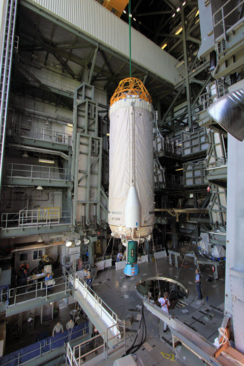
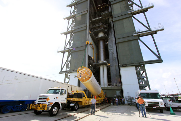
The first stage of the Atlas V rocket for NASA's Mars Science Laboratory (MSL) mission is lifted into an upright position for placement inside the Vertical Integration Facility at Space Launch Complex 41 on Cape Canaveral Air Force Station. A United Launch Alliance Atlas V-541 configuration will be used to loft MSL into space. NASA/Jim Grossmann
[/caption]
Assembly of the powerful Atlas V booster that will rocket NASA’s Curiosity Mars Science Laboratory rover to Mars is nearly complete. The Atlas V is taking shape inside the Vertical Integration Facility at Space Launch Complex 41 at Cape Canaveral Air Force Station in Florida.
The rocket is built by United Launch Alliance under contract to NASA as part of NASA’s Launch Services Program to loft science satellites on expendable rockets.
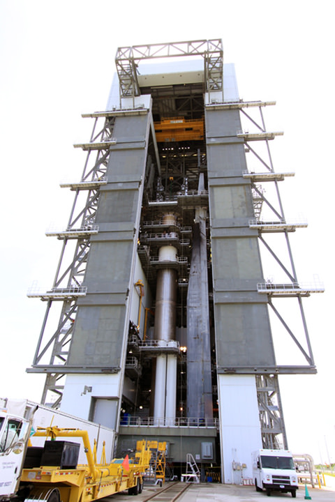
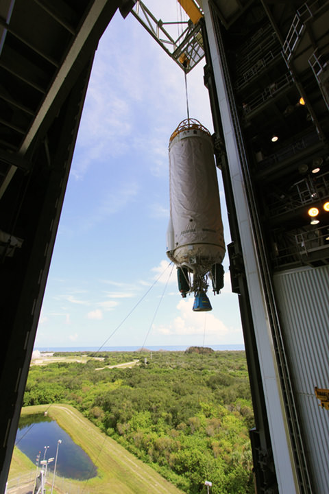
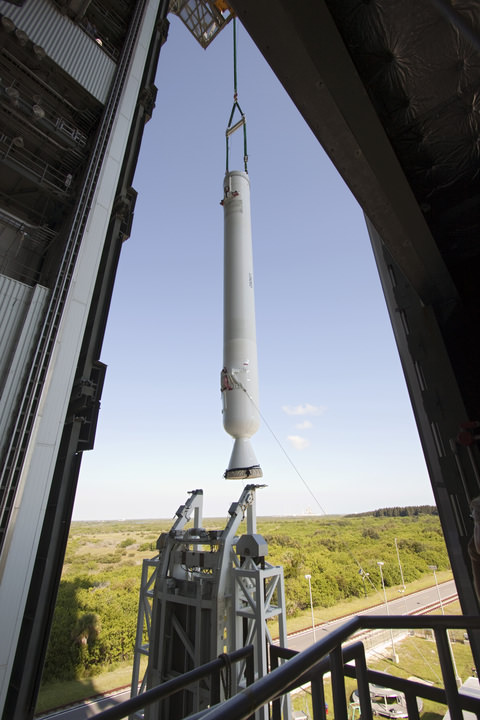
At Launch Complex 41 at Cape Canaveral Air Force Station in Florida, workers guide an overhead crane as it lifts the Centaur upper stage for the United Launch Alliance Atlas V in the Vertical Integration Facility (VIF). Once in position, it will be attached to the Atlas V booster stage, already at the pad. Credit: NASA/Jim Grossmann
The Atlas V configuration for Curiosity is similar to the one used for Juno except that it employs one less solid rocket motor in a designation known as Atlas 541.
4 indicates a total of four solid rocket motors are attached to the base of the first stage vs. five solids for Juno. 5 indicates a five meter diameter payload fairing. 1 indicates use of a single engine Centaur upper stage.
Blastoff of Curiosity remains on schedule for Nov. 25, 2011, the day after the Thanksgiving holiday in the U.S. The launch window for a favorable orbital alignment to Mars remains open until Dec. 18 after which the mission would face a 26 month delay at a cost likely to be in the hundreds of millions of dollars.
Curiosity is set to touchdown on Mars at Gale Crater between August 6 & August 20, 2012. The compact car sized rover is equipped with 10 science instruments that will search for signs of habitats that could potentially support martian microbial life, past or present if it ever existed.
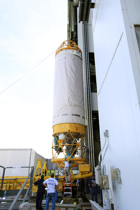
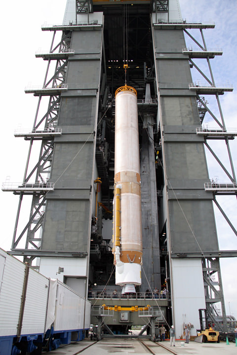
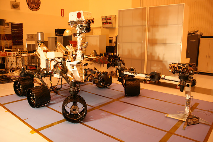
At the Vertical Integration Facility (VIF) at Launch Complex 41 at Cape Canaveral Air Force Station in Florida, the Centaur upper stage for the United Launch Alliance Atlas V is in position in the Vertical Integration Facility (VIF). It then will be attached to the Atlas V booster stage, already at the pad. The Atlas V is slated to launch NASA's Mars Science Laboratory (MSL) mission - the compact car-sized Curiosity Mars rover. Credit: NASA With a unique view taken from inside Vertical Integration Facility (VIF) at Launch Complex 41 at Cape Canaveral Air Force Station in Florida, an overhead crane lifts the Centaur upper stage for the United Launch Alliance Atlas V. Once in position in the VIF it will be attached to the Atlas V booster stage, already at the pad. NASA/Jim GrossmannWorkers guide an overhead crane as it lifts the Centaur upper stage for the United Launch Alliance Atlas V into the Vertical Integration Facility (VIF). NASA/Jim GrossmannAn overhead crane lifts the Centaur upper stage for the Atlas V. NASA/Jim GrossmannThe final solid rocket motor (SRM) hangs in an upright position for mating to a United Launch Alliance Atlas V rocket. NASA/Jim GrossmannA crane lifts the 106.5-foot-long first stage of the Atlas V rocket for NASA's Mars Science Laboratory (MSL) mission through the open door of the Vertical Integration Facility at Space Launch Complex 41. Credit: NASA/Cory HustonCuriosity Mars Science Laboratory Rover - inside the Cleanroom at KSC. Credit: Ken Kremer
Meanwhile NASA’s Opportunity Mars rover is nearing 8 continuous years of Exploration and Discovery around the Meridiani Planum region of the Red Planet.
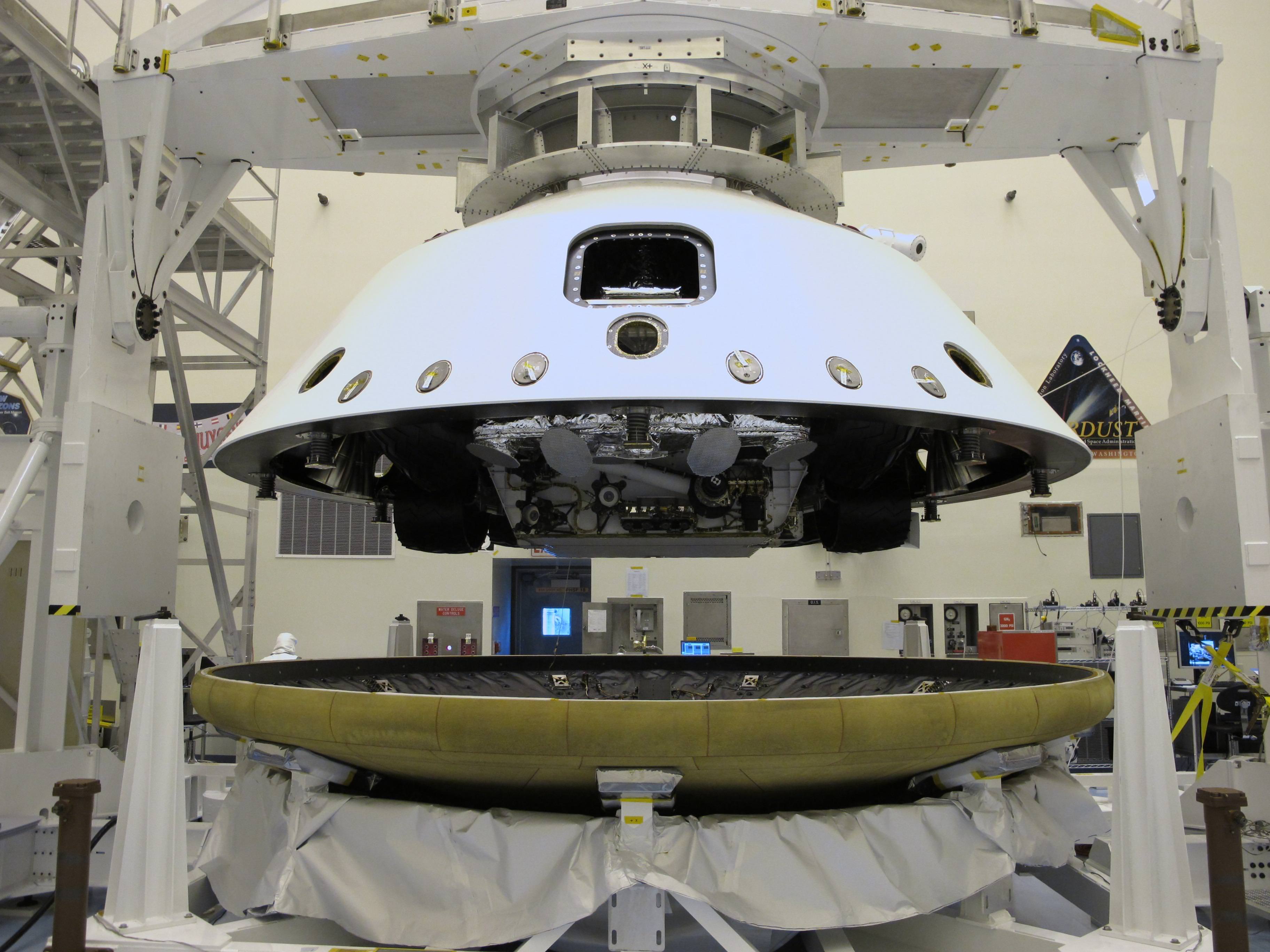
NASA’s Curiosity Mars Science Laboratory Rover inside the entry aeroshell. At the Payload Hazardous Servicing Facility at NASA's Kennedy Space Center in Florida, the "back shell powered descent vehicle" configuration, containing NASA's Mars Science Laboratory rover, Curiosity, is being placed on the spacecraft's heat shield. Credit: NASA/JPL-Caltech
[/caption]
With just over 6 weeks to go until the liftoff of Curiosity – NASA’s next Mars rover – prelaunch processing at the Kennedy Space Center (KSC) in Florida is rapidly entering the home stretch. Technicians placed the folded rover inside the complete aeroshell to match the Martian entry configuration components together and conduct preflight testing of the integrated assembly at the Payload Hazardous Servicing Facility at KSC. The aeroshell is comprised of the heat shield and back shell and encapsulates Curiosity during the long voyage to Mars.
The job of the aeroshell is to protect the Curiosity Mars Science Laboratory (MSL) from the intense heat of several thousand degrees F(C) generated by friction as the delicate assemblage smashes into the Martian atmosphere during the terrifying entry and descent to the surface.
Curiosity Mars Science Laboratory Rover - inside the Cleanroom at KSC. Credit: Ken Kremer
The rover itself has been mated to the back shell powered descent vehicle, known as the PDV or sky crane. The rocket powered descent stage (PDV) is designed to maneuver through the Martian atmosphere, slow the descent and safely set Curiosity down onto the surface at a precise location inside the chosen landing site of Gale Crater.
Technicians still have several more weeks of hardware testing and planetary protection checks ahead before NASA’s minivan sized Martian robot is encapsulated inside the aeroshell for the final time.
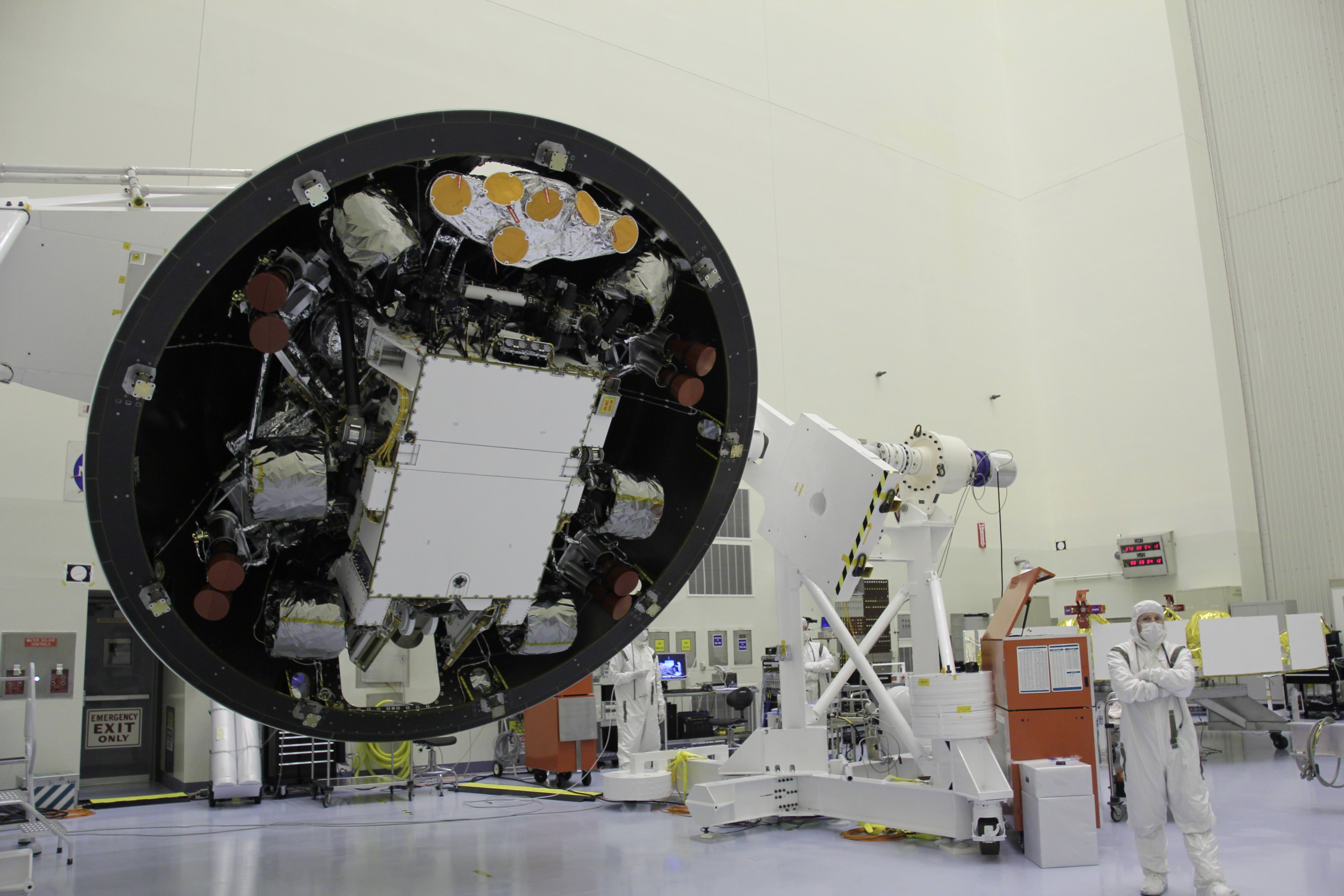
Rotating Curiosity's Back Shell Powered Descent Vehicle
At the Payload Hazardous Servicing Facility at the Kennedy Space Center in Florida, the "back shell powered descent vehicle" configuration of NASA's Mars Science Laboratory is being rotated for final closeout actions. At this time Curiosity and its rocket-powered descent stage have already been integrated, and are now encapsulated inside the spacecraft's back shell. The configuration of rover integrated with the descent stage is the "powered descent vehicle." The back shell, a protective cover, carries the parachute and several other components used during descent. The yellow disks visible at the top of the configuration are the descent stage's radar antennas that will be used to calculate the rover's descent speed and altitude. Credit: NASA/JPL-Caltech
Another major task still to be completed is mating the aeroshell to the cruise stage and then fueling of the cruise stage, which guides MSL from the Earth to Mars, according to Guy Webster, press spokesman for NASA’s Jet Propulsion Laboratory which manages the MSL project for NASA.
The launch of the $2.5 Billion Curiosity rover atop an Atlas V rocket is slated for Nov. 25, the day after Thanksgiving, and the launch window extends until Dec. 18. Arrival at Gale crater is set for August 2012.
Curiosity is by far the most scientifically advanced surface robotic rover ever sent beyond Earth and will search for environmental conditions that could have been favorable to support Martian microbial life forms if they ever existed in the past or present.
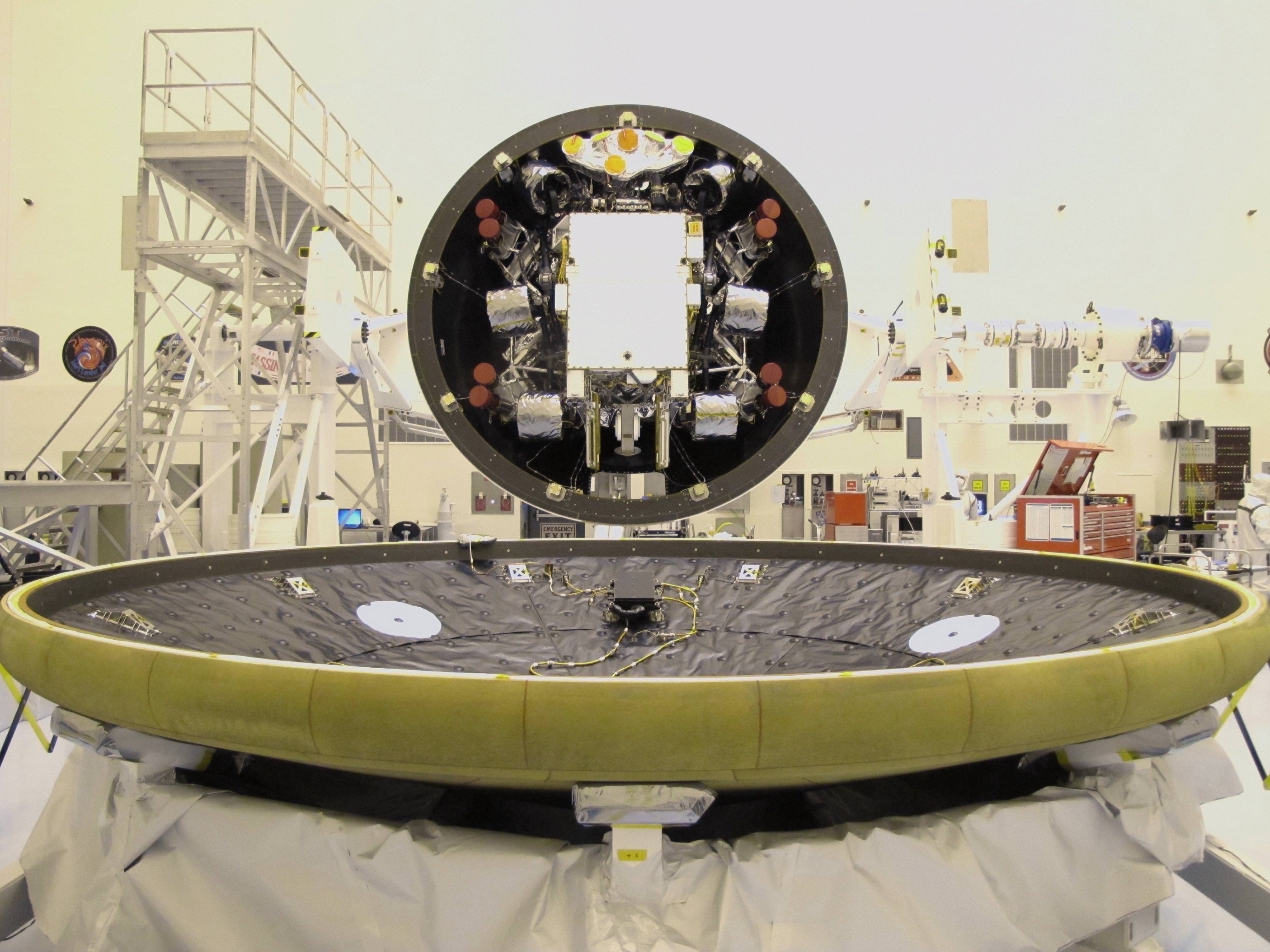
Final Closeout Actions for Curiosity's Heat Shield and Back Shell
At the Payload Hazardous Servicing Facility at NASA's Kennedy Space Center in Florida, the "back shell powered descent vehicle" configuration, containing NASA's Mars Science Laboratory rover, Curiosity, is being rotated for final closeout actions. The flat, circular object in the foreground of the image is the spacecraft's heat shield. The heat shield and the back shell will together form an encapsulating aeroshell that will protect the rover from the intense heat and friction that will be generated as the flight system descends through the Martian atmosphere.Credit: NASA/JPL-Caltech
Mike Killian is an aerospace journalist who jumped at the opportunity to cover space events at Kennedy Space Center and Cape Canaveral Air Force Station. Photos Courtesy of Mike Killian
[/caption]CAPE CANAVERAL, Fla – The photographers that cover the events that take place in and around Florida’s Space Coast come from diverse backgrounds. However, when it comes to the passion that attracts so many to Cape Canaveral Air Force Station and Kennedy Space Center – their origins are very similar.
Many amateur photographers like Mike Killian have always been interested in spaceflight, in capturing the spectacle of launch. Like Killian, these photographers start out not knowing how to get onto Kennedy Space Center to shoot the launches and other events that take place there. They work out arrangements with NASA friends to get close and then, finally, they get affiliated with an accredited news organization (in Killian’s case the ARES Institute).
“I have loved the space program since I was a child,” Killian said. “Most folks that come out here and do this I doubt very highly that they do it thinking they will get rich. They do it because what they are showing the world is so important, so awe-inspiring…and so beautiful.”
Killian caught the reflection of space shuttle Atlantis as it was towed back to its OPF after completing the final mission of the space shuttle era - STS-135. Photo Courtesy of Mike Killian
Killian has only covered the space program as a photographer for a relatively short time, about three years. During that time however – he has covered some pivotal points in space flight history. The last flights of the space shuttle era, the launch of spacecraft to Earth orbit, the Moon and soon Mars. Killian, also like his compatriots, sacrifices long hours and endures low pay to capture images of these events. But when he gets that perfect shot of solid rocket boosters separating from an Atlas V on its way to orbit, or the final landing of the space shuttle – it is all worth it.
“Photography is pretty much like anything else,” said Killian during a recent interview. “It’s all about timing – being at the right place – at the right time.”
Whether static or in dramtic motion, Killian has captured the space shuttle program's final days. Photo Courtesy of Mike Killian
One recurring theme that occurs in aerospace photography is – progression. Photographers will come out to KSC/CCAFS with their digital cameras, then they will buy a more powerful camera and then they move on to remote cameras. When one hears remote they think the cameras are far away – the truth is that these cameras are extremely close. “Remote” means that they are remotely activated – generally by either a sound or light sensor.
Killian employs 2 Canon Rebel XSi cameras due to the camera’s affordability and versatility.
The 27-year-old, unlike many of his colleagues, does have a favorite image – and it isn’t even one that he took on Kennedy Space Center proper.
Killian's favorite shot shows Launch Complex 39A in the distance, a Shuttle Training Aircraft or STA checking weather conditions - and a very active thunderstorm. Photo Courtesy of Mike Killian
“My favorite shot thus far is of a lightning storm over KSC for the night launch of Discovery on STS-128. That storm scrubbed the launch attempt, but the images I captured that night were unreal,” said Killian. “This particular photo has so much going on – Discovery basking in xenon lights atop launch pad 39A fully fueled with her crew onboard, lightning racing through the clouds directly above KSC, & the shuttle training aircraft flying over the storm (upper left of photo) on weather recon trying to determine if there would be any chance the storm could let up in time to support a launch that night. It’s very unique, not your typical launch photo.”
For Killian photographing the space program allows him to both combine his love of photography with the driving interest that he has for space flight. Killian has no plans to stop photographing the space program anytime soon. For him this is not about the money, it’s about the history of thunder and the wonder of light and like so many of his fellow photojournalists he feels privileged to be able to do what he does.
Killian has covered many different events at Kennedy Space Center. His camera has captured events as stirring as the final launch of the shuttle era - and as poignant as the final rollout of space shuttle Discovery (seen here). Images Courtesy of Mike Killian
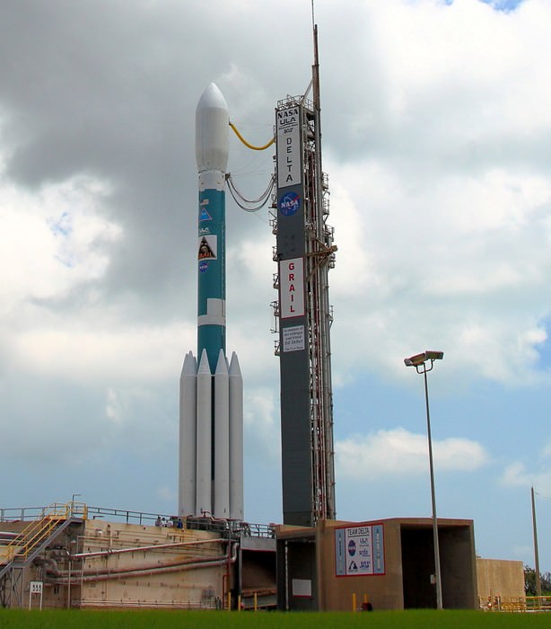
United Launch Alliance's Delta II rocket has been added to the National Launch Services II contract by NASA. Photo Credit: Alan Walters/awaltersphoto.com
[/caption]
NASA announced that it has added the Delta II rocket, a launch vehicle that appeared to be slipping into history, to the NASA Launch Services (NLS) II contract. The Delta II, produced by United Launch Alliance, is one of the most successful expendable launch vehicles that has ever been produced.
This modification of the contract will allow ULA to add the Delta II rocket as part of the contract’s on-ramp provision. The modification allows United Launch Services to offer as much as five Delta II rockets.
The Delta II was most recently utilized to launch the GRAIL mission to study the Moon's composition. Photo Credit: Mike Killian/ARES Institute
“We are extremely pleased NASA has added the reliable Delta II to the NLS II contract and look forward to continuing the legacy of the program,” said Michael Gass, ULA’s president and CEO. “ULA has demonstrated its ability to fully integrate Atlas V, Delta IV and Delta II product lines allowing us to continue offering medium launch capability at the best value for our customers.”
The Delta II rocket, in its various configurations has been launched 150 times and has a success rate of 98.7 percent. The one notable failure was the 1997 launch of a U.S. Air Force Global Positioning IIR-1 satellite (GPS IIR-1). Within 13 seconds of launch the Delta II exploded causing severe destruction to the surrounding area. The cause of this mishap was determined to be a crack within one of the GEM-40 solid rocket boosters that are affixed to the base of the Delta II.
The Delta II rocket has a very extensive history of success and has been used to launch many famous missions. Image Credit: NASA/JPL
“While we count success one mission at a time, we have been able to count on the Delta II’s success 96 times in a row over the last decade,” Gass said. “This is a tribute to our dedicated ULA employees, our supplier teammates and our NASA Launch Services Program customer who ensures mission success is the focus of each and every launch.”
The planetary science missions that the rocket has sent into space reads like a “Who’s Who” of space exploration missions. The Mars Exploration Rovers Spirit and Opportunity, Mars Phoenix Lander, Genesis, Stardust, Mars Pathfinder, Mars Global Surveyor, Messenger, Deep Impact, Dawn, Kepler, Wise and the recent GRAIL mission to the Moon – all thundered to orbit atop a Delta II.
The Delta II rocket is launched from either Vandenberg Air Force Base in California or Cape Canaveral Air Force Station located in Florida. Photo Credit: NASA.gov
ULA’s next planned launch of a Delta II will carry the NPOESS Preparatory Project (NPP) mission for NASA. It is currently slated to launch Oct. 25, 2011 from Space Launch Complex-2 at Vandenberg Air Force Base, located in California. ULA launches from both Vandenberg as well as Cape Canaveral Air Force Station, located in Florida.
While this change does allow for at least five more launches of the Delta II, after those launches, the rocket will no longer be utilized and will be phased out of service.
The NLS II contracts are designed to provide for payloads weighing about 550 pounds or more to be sent to a minimum 124-mile-high circular orbit. The launch service providers signed into these contracts also may offer different launch vehicles to NASA to meet other requirements. NASA can also provide launch services to other agencies, such as the National Oceanic and Atmospheric Administration or NOAA.
Spirit and Opportunity, Pathfinder, Deep Impact, Dawn, Kepler, Stardust, Genesis and Wise - were all launched on the Delta II rocket. Photo Credit: NASA/George Shelton
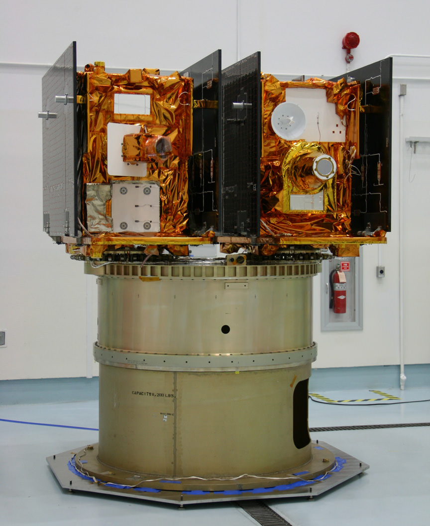
NASA announces student Essay Naming Contest for the twin GRAIL Lunar spaceships. The essay writing contest is open to students in Grades K - 12 at schools in the United States. Submission Deadline is November 11, 2011. GRAIL A & B are twin science robots that will explore the gravity field of the moon like never before.
[/caption]
Student Alert ! – Here’s your once in a lifetime chance to name Two NASA robots speeding at this moment to the Moon on a super science mission to map the lunar gravity field. They were successfully launched from the Earth to the Moon on September 10, 2011. Right now the robots are called GRAIL A and GRAIL B. But, they need real names that inspire. And they need those names real soon. The goal is to “capture the spirit and excitement of lunar exploration”, says NASA – the US Space Agency.
NASA needs your help and has just announced an essay writing contest open to students in Grades K – 12 at schools in the United States. The deadline to submit your essay is November 11, 2011. GRAIL stands for “Gravity Recovery And Interior Laboratory.”
The rules state you need to pick two names and explain your choices in 500 words or less in English. Your essay can be any length up to 500 words – even as short as a paragraph. But, DO NOT write more than 500 words or your entry will be automatically disqualified.
Learn more about the GRAIL Essay Naming Contest here:
Students: NASA Wants You to Name that GRAIL !
Write an Essay and name these twin Lunar mapping satellites. NASA’s twin GRAIL A & B science probes are now streaking to the Moon and arrive on New Year’s Day 2012. This picture shows how they looked, mounted side by side, during launch preparations prior to blasting off for the Moon on Sept. 10, 2011 from Florida. Credit: Ken Kremer
The GRAIL A and B lunar spaceships are twins – just like those other awe inspiring robots “Spirit” and “Opportunity” , which were named by a 10 year old girl student and quickly became famous worldwide and forever because of their exciting science missions of Exploration and Discovery.They arrive in Lunar Orbit on New Year’s Day 2012.
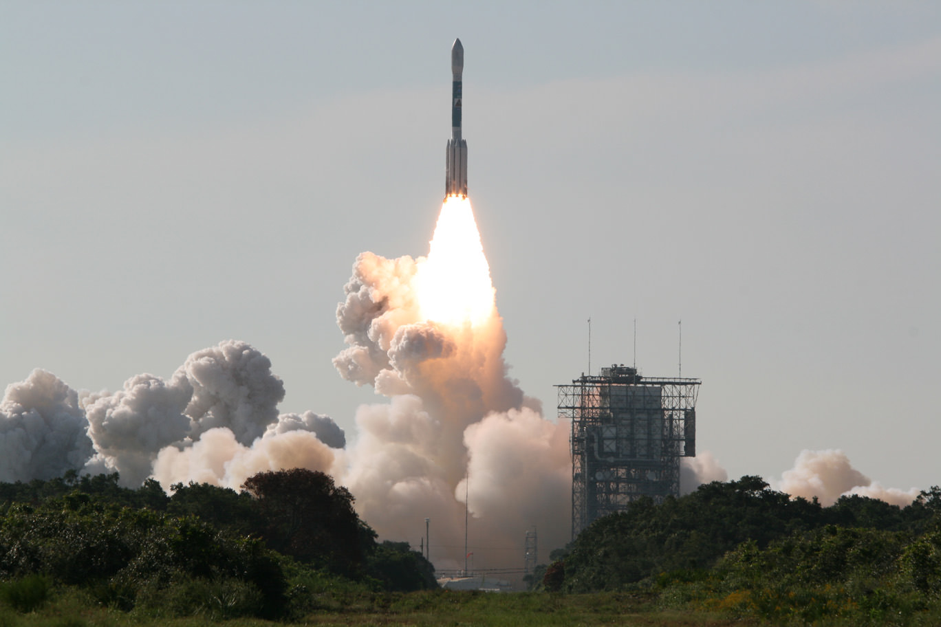
Blastoff of twin GRAIL A and B lunar gravity mapping spacecraft on a Delta II Heavy rocket on Sept. 10 from Pad 17B Cape Canaveral Air Force Station in Florida at 9:08 a.m. EDT. Credit: Ken Kremer
And there is another way that students can get involved in NASA’s GRAIL mission.
GRAIL A & B are both equipped with four student-run MoonKAM cameras. Students can suggest targets for the cameras. Then the cameras will take close-up views of the lunar surface, taking tens of thousands of images and sending them back to Earth.
“Over 1100 middle schools have signed up to participate in the MoonKAM education and public outreach program to take images and engage in exploration,” said Prof. Maria Zuber of MIT.
Prof. Zuber is the top scientist on the mission and she was very excited to announce the GRAIL Essay Naming contest right after the twin spaceships blasted off to the Moon on Sep 10, 2011 from Cape Canaveral in Florida.
What is the purpose of GRAIL ?
“GRAIL simply put, is a ‘Journey to the Center of the Moon’,” says Dr. Ed Weiler, NASA Associate Administrator of the Science Mission Directorate in Washington, DC.
“It will probe the interior of the moon and map its gravity field by 100 to 1000 times better than ever before. We will learn more about the interior of the moon with GRAIL than all previous lunar missions combined. Precisely knowing what the gravity fields are will be critical in helping to land future human and robotic spacecraft. The moon is not very uniform. So it’s a dicey thing to fly orbits around the moon.”
“There have been many missions that have gone to the moon, orbited the moon, landed on the moon, brought back samples of the moon,” said Zuber. “But the missing piece of the puzzle in trying to understand the moon is what the deep interior is like.”
So, what are you waiting for.
Start thinking and writing. Students – You can be space explorers too !
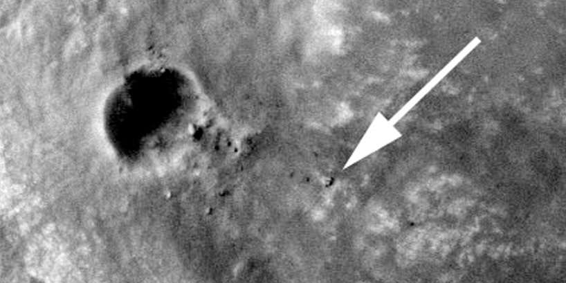
Opportunity captured at Endeavour Crater rim on Sept 10, 2011, Sol 2712. Opportunity is visible at the end of the white arrow, sitting atop some light toned outcrops on the rim of Endeavour Crater located at the southern tip of a rim segment named Cape York. Opportunity is ascending Endeavour at Cape York ridge and positioned to the right of the small crater named Odyssey. This image was taken by the HiRISE camera aboard NASA’s Mars Reconnaissance Orbiter (MRO), Opportunity travelled nearly three years to reach this rim because it contains rocks even more ancient than the rocks of Meridiani Planum, which the rover has been exploring since 2004, and hence may teach us something about an even more ancient era in Martian history. Click to enlarge. Credit: NASA/JPL/University of Arizona
[/caption]
Opportunity has just been imaged in high resolution at Endeavour crater by a powerful NASA camera orbiting overhead in Mars orbit. The new image (see above) was snapped while NASA’s long lived robot was climbing a hilltop offering spectacular panoramic vistas peering into the vast crater which is some 14 miles (22 km) wide.
The HiRiSE camera aboard NASA’s Mars Reconnaissance Orbiter photographed Opportunity and her wheel tracks on September 10, 2011, or Martian Sol 2712 for a mission warrentied to last only 90 Sols ! The rover is sitting to the right of another small crater known as Odyssey. Click to enlarge the image.
Look very closely and you’ll even be able to easily discern the rovers pair of tire tracks showing the path traversed by the robot as she explores the crater and the ejecta rocks and boulders excavated and strewn about by an ancient impact.
Opportunity imaged at Endeavour crater rim with wheel tracks exploring Odyssey crater, rocks and boulders climbing up Cape York ridge. Credit: NASA/JPL/University of Arizona
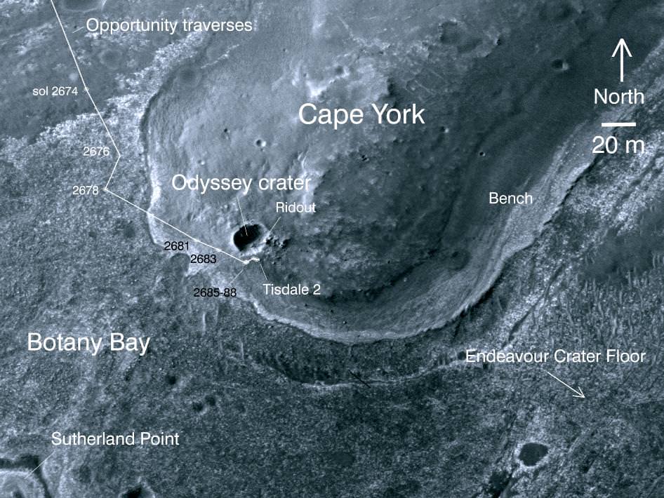
Opportunity is ascending up the rim of Endeavour crater at the southern tip of a low ridge dubbed Cape York – a location that has already yielded a bonanza of new science data since her recent arrival in August 2011 after a more than 20 mile (33 km) epic trek.
The intrepid rover discovered a rock unlike any other since she safely landed at the Meridiani Planum region of Mars nearly eight years ago on Jan. 24, 2004.
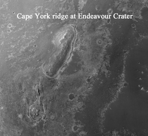
Opportunity is now searching Endeavour crater and Cape York for signatures of phyllosilicates – clay minerals that formed in the presence of pH neutral water flowing on Mars surface billions of years ago. Cape York ridge at Endeavour Crater - From Orbit
This image taken from Mars orbit shows the path driven by NASA's Mars Exploration Rover Opportunity in the weeks around the rover's arrival at the rim of Endeavour crater and up to Sol 2688. Opportunity has since driven a short distance to the right. Credit: NASA/JPL-Caltech/University of Arizona
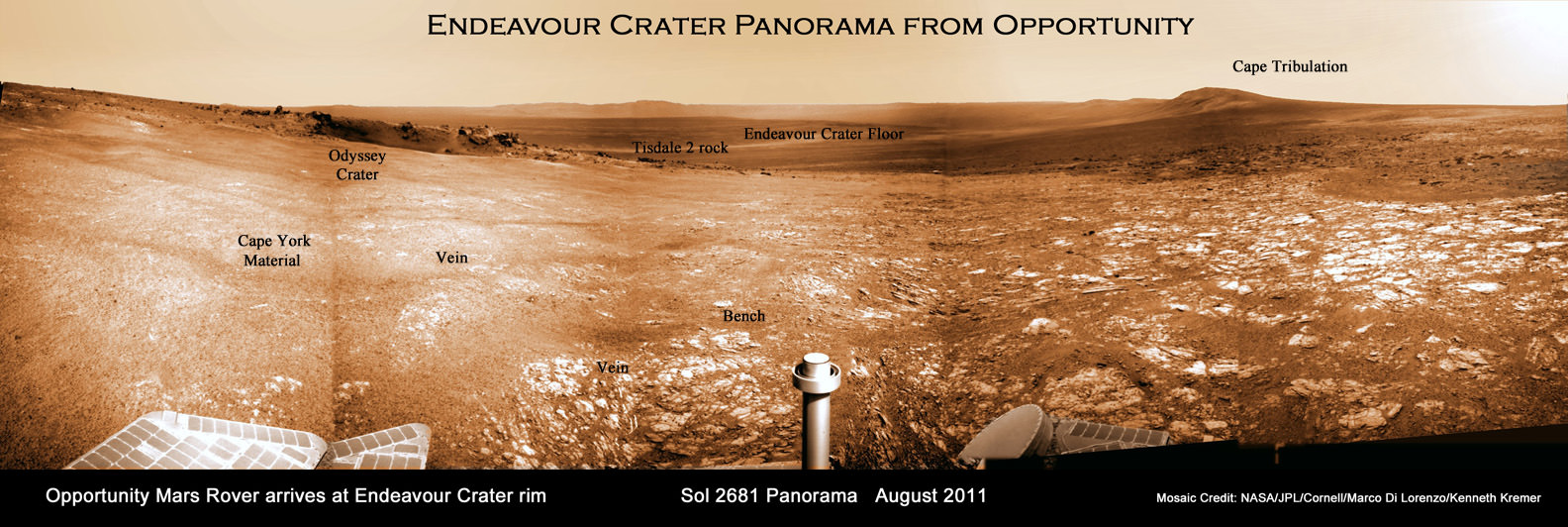
Endeavour Crater Panorama from Opportunity, Sol 2681, August 2011
Opportunity arrived at the rim of Endeavour on Sol 2681, August 9, 2011 and climbed up the ridge known as Cape York. Odyssey crater is visible at left. Opportunity has since driven a short distance beyond Odyssey crater and was photographed from Mars orbit on Sept. 10, 2011.
Mosaic Credit: NASA/JPL/Cornell/Marco Di Lorenzo/Kenneth Kremer
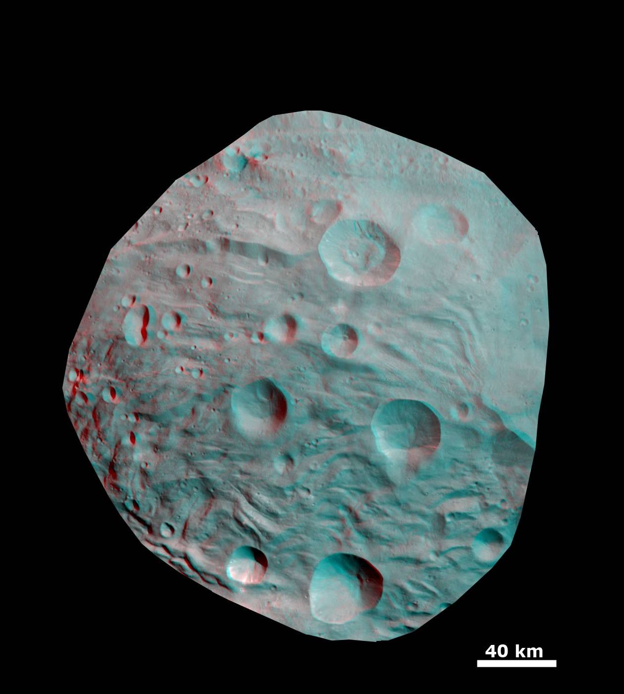
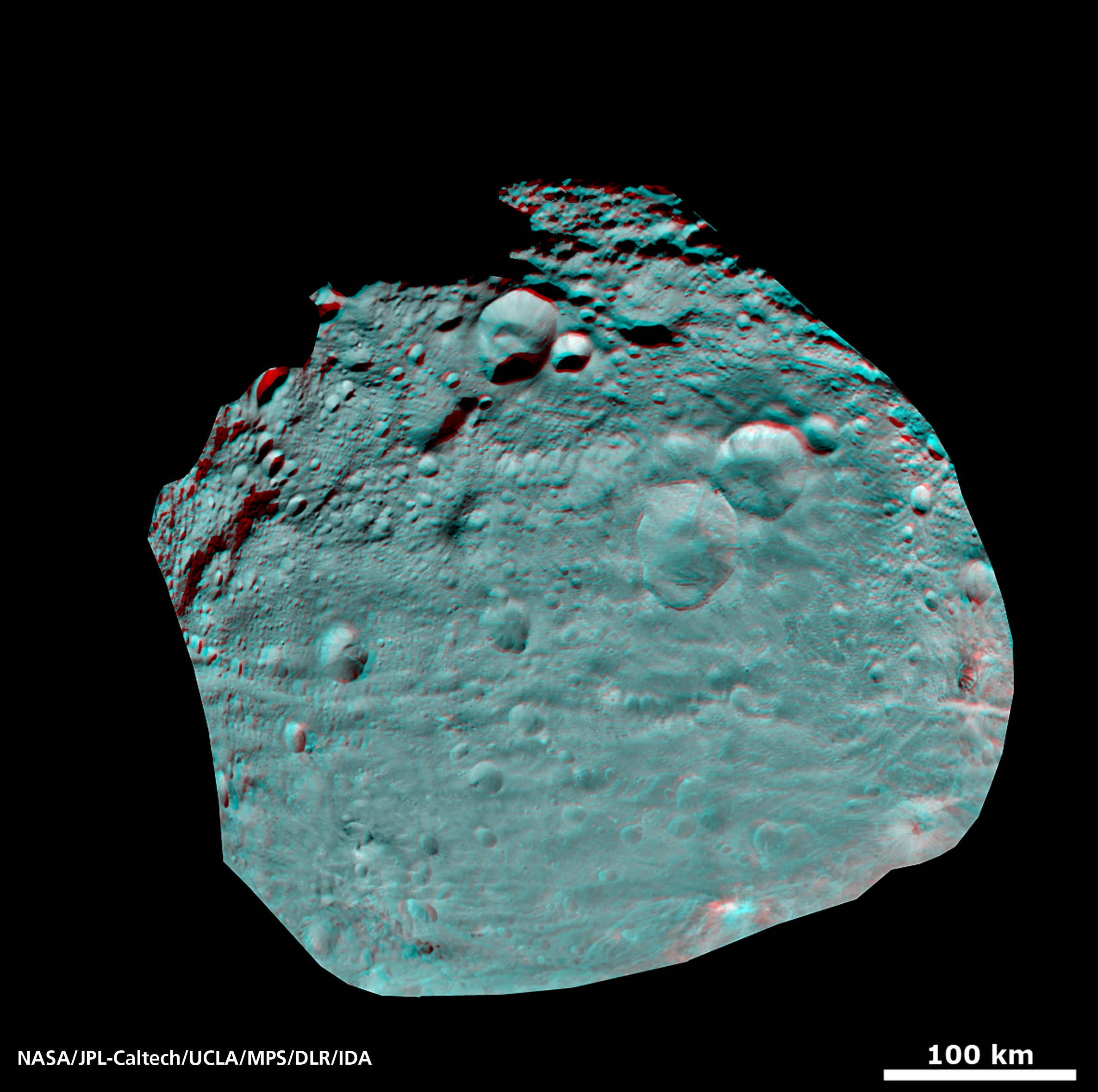
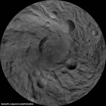
3 D Anaglyph of Craters at Rheasilvia - the South Polar Region of Vesta. This 3-D image shows the topography, craters and grooves of Vesta’s south polar region obtained by the framing camera instrument aboard NASA’s Dawn spacecraft on Aug. 23 and 28, 2011. The image has a resolution of about 260 meters per pixel.
[/caption]
Try not to plummet off a steep crater cliff or be buried under a landslide while gazing at the irresistibly alluring curves of beautiful Rheasilvia – the mythical mother of Romulus and Remus – whose found a new home at the South Pole of the giant Asteroid Vesta.
3 D is undoubtedly the best way to maximize your pleasure. So whip out your cool red-cyan anaglyph glasses to enhance your viewing experience of Rheasilvia, the Snowman and more – and maximize your enjoyment of this new 3 D collection showcasing the heavily cratered, pockmarked, mountainous and groovy terrain replete at Vesta.
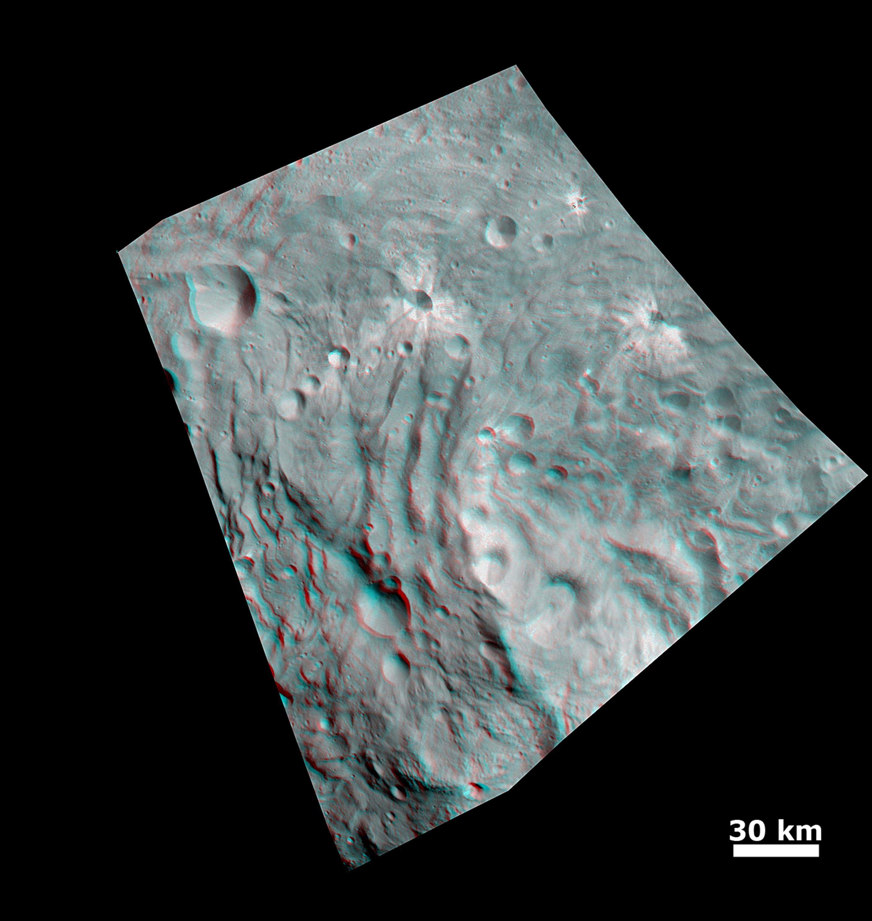
3D Details of Wave-Like Terrain in the South Pole of Vesta
This image was obtained by NASA’s Dawn spacecraft from an orbit of about 1,700 miles (2,700 kilometers) above the surface of the giant asteroid Vesta. Topography in the area surrounding Vesta's south pole area shows impact craters, ridges and grooves. These images in 3D provide scientists with a realistic impression of the solid surface of the celestial body.
Credit: NASA/JPL-Caltech/UCLA/MPS/DLR/IDA
Can you find the location of the 3 D image above in the 2 D South Pole image below?
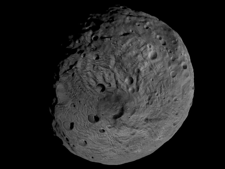
Scientists and mortals have been fascinated by the enormous impact crater Rheasilvia and central mountain unveiled in detail by NASA’s Dawn Asteroid Orbiter recently arrived at Vesta, the 2nd most massive object in the main asteroid belt. Ceres is the largest object and will be Dawn’s next orbital target in 2015 after departing Vesta in 2012.
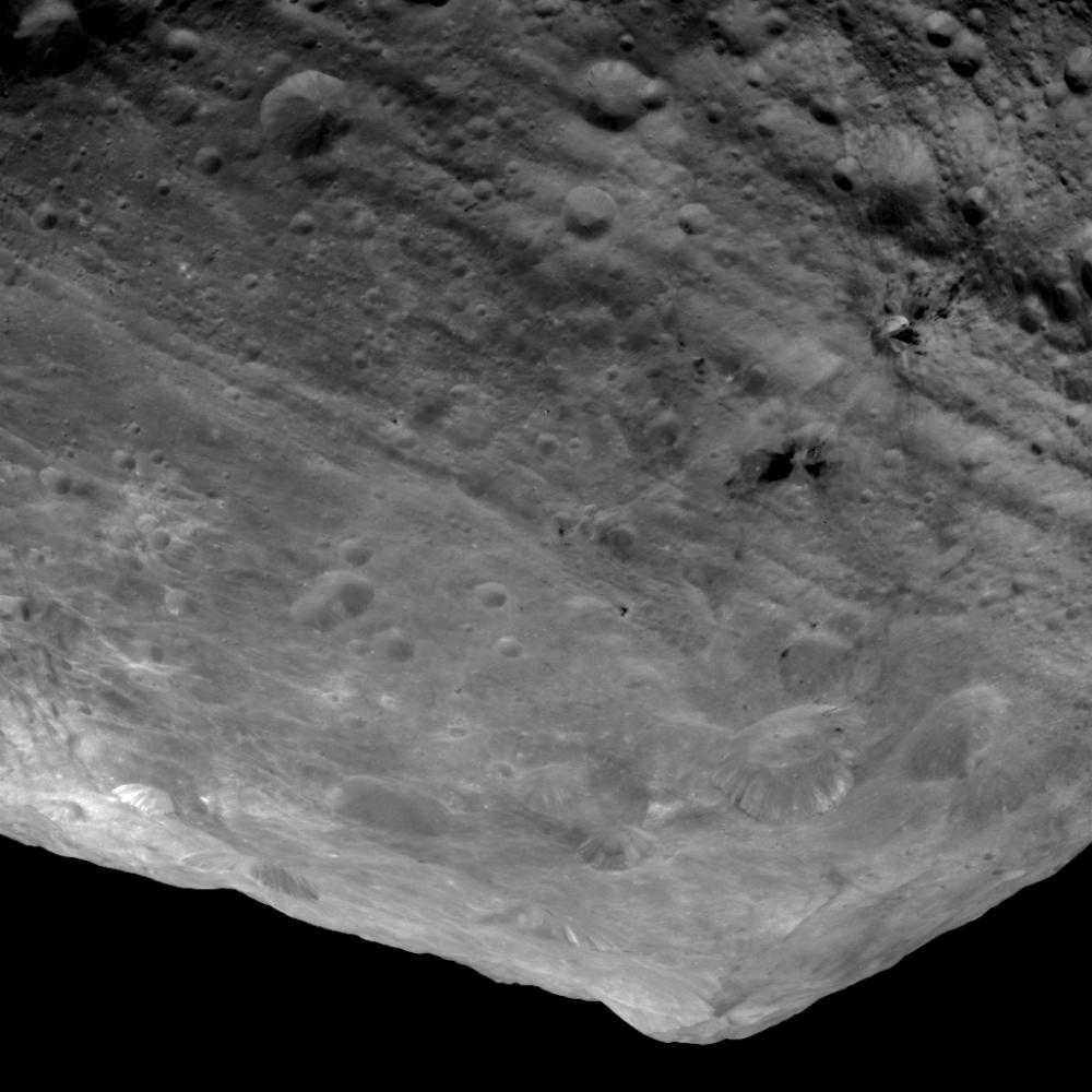
3D - A Big Mountain at Asteroid Vesta’s South Pole
Scientists were fascinated by this enormous mound inside a big circular depression at the south pole- dubbed Rheasilvia. This stereo image was recorded from an altitude of about 1,700 miles (2,700 kilometers) above the surface and shows the structure of the mountain, displayed in the right half of this 3D image. The base of the mountain has a diameter of about 125 miles (200 kilometers), and its altitude above the surroundings is about 9 miles (15 kilometers). The vicinity of the peak of the mountain shows landslides that occurred when material from the flanks of the mountain were slipping down. Also visible are tectonic structures from tension in Vesta's crust. Credit: NASA/JPL-Caltech/UCLA/MPS/DLR/IDA
“Vesta is the smallest terrestrial planet in our Solar System”, said Chris Russell in an interview with Universe Today. “We do not have a good analog to Vesta anywhere else in the Solar System.”
And the best is yet to come. In a few days, Dawn begins snapping images from a much lower altitude at the HAMO mapping orbit of ca. 685 km vs the initial survey orbit of ca, 2700 km. where most of these images were taken.
Can you find the location of the 3 D South Pole images above in the 2 D South Pole image below?
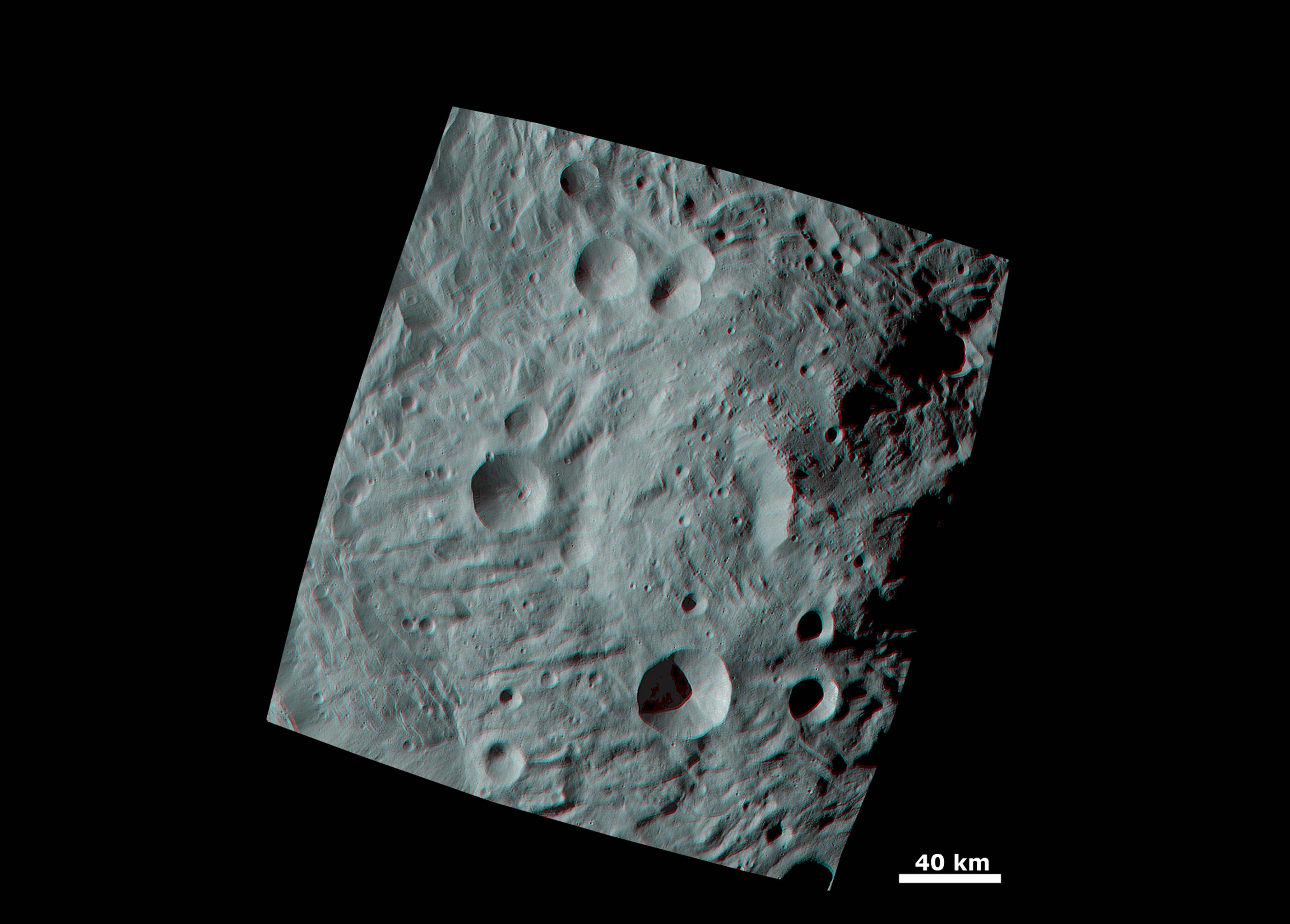
Topography of Densely Cratered Deformed Terrain
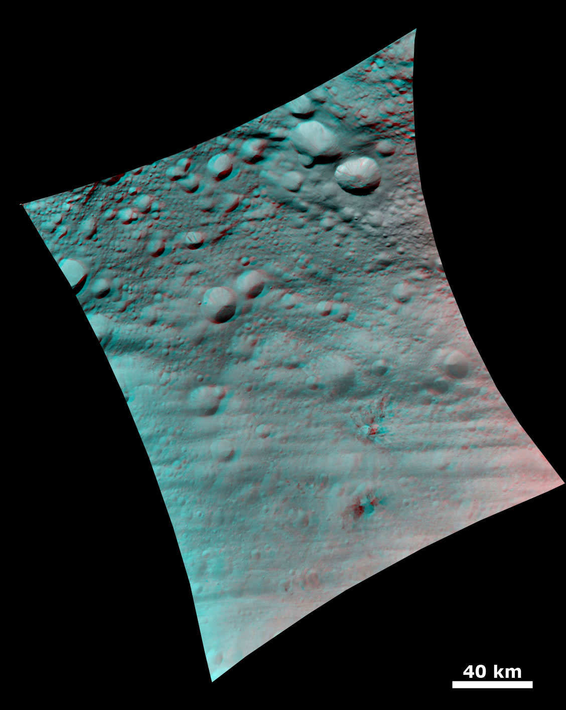
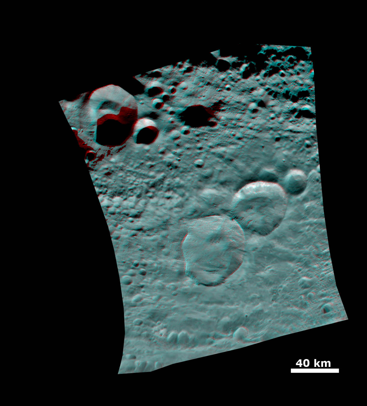
This 3 D anaglyph image shows the topography of Vesta's densely cratered terrain obtained by the framing camera instrument aboard NASA's Dawn spacecraft on August 6, 2011. Credit: NASA/JPL-Caltech/UCLA/MPS/DLR/IDAAnaglyph of the ‘Snowman' Crater. This anaglyph image shows the topography of Vesta's three craters, informally named the "Snowman," obtained by the framing camera instrument aboard Dawn on August 6, 2011. The camera has a resolution of about 260 meters per pixel. Credit: NASA/JPL-Caltech/UCLA/MPS/DLR/IDAVesta's Ancient, Cratered Surface in 3D
This image of the giant asteroid Vesta obtained by NASA's Dawn spacecraft shows the surface of the asteroid from an orbit of about 1,700 miles (2,700 kilometers) above the surface. Numerous impact craters illustrate the asteroid's violent youth. By counting craters on distinct geological surfaces scientists can deduce relative ages of the asteroid's surface. This 3D view provides scientists the opportunity to learn more about the morphology of craters on asteroids and physical properties of the material at Vesta's surface.. Image resolution is about 260 meters per pixel. Credit: NASA/JPL-Caltech/UCLA/MPS/DLR/IDAViewing the South Pole of Vesta and Rheasilvia Impact Basin
This image obtained by Dawns framing camera shows the south pole of the giant asteroid Vesta. Scientists are discussing whether the Rheasilvia circular structure that covers most of this image originated by a collision with another asteroid, or by internal processes early in the asteroid's history. Images in higher resolution from Dawn's next lowered orbit might help answer that question. The image was recorded from a distance of about 1,700 miles (2,700 kilometers). The image resolution is about 260 meters per pixel. Credit: NASA/JPL-Caltech/UCLA/MPS/DLR/IDARhea Silvia, torso from the amphitheatre at Cartagena in Spain that was rediscovered in 1988. Rhea Silvia was the mother of Romulus and Remus, the mythical founders of Rome. Source: Wikipedia
Read Ken’s continuing features about Dawn and Vesta
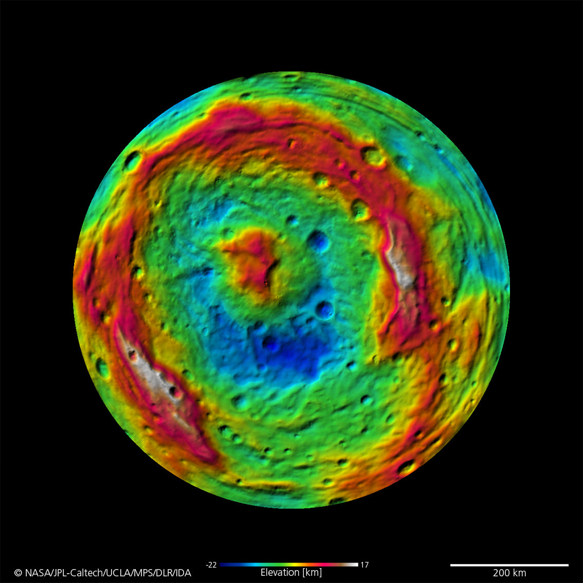
A False-Color Topography of Vesta's South Pole. This false-color map of the giant asteroid Vesta was created from stereo images obtained by the framing camera aboard NASA’s Dawn spacecraft. The image shows the elevation of surface structures with a horizontal resolution of about 750 meters per pixel. The terrain model of Vesta's southern hemisphere shows a big circular structure with a diameter of about 300 miles (500 kilometers), its rim rising above the interior of the structure for more than 9 miles (15 kilometers.) Image credit: NASA/JPL-Caltech/UCLA/MPS/DLR/IDA
Video caption: Rheasilvia Impact Basin and Vesta shape model. This false-color shape model video of the giant asteroid Vesta was created from images taken by the framing camera aboard NASA’s Dawn spacecraft. Rheasilvia – South Pole Impact Basin – shown at bottom (left) and head on (at right). Credit: NASA/JPL-Caltech/UCLA/MPS/DLR/IDA
‘Rheasilvia’ – that’s the brand new name given to the humongous and ever more mysterious South Pole basin feature being scrutinized in detail by Dawn, according to the missions top scientists in a Universe Today exclusive. Dawn is NASA’s newly arrived science orbiter unveiling the giant asteroid Vesta – a marvelously intriguing body unlike any other in our Solar System.
What is Rheasilvia? An impact basin? A crater remnant? Tectonic action? A leftover from internal processes? Or something completely different? That’s the hotly debated central question consuming loads of attention and sparking significant speculation amongst Dawn’s happily puzzled international science team. There is nothing closely analogous to Vesta and Rhea Silvia – and thats a planetary scientists dream come true.
“Rheasilvia – One thing that we all agree on is that the large crater should be named ‘Rheasilvia’ after the mother of Romulus and Remus, the mythical mother of the Vestals,” said Prof. Chris Russell, Dawns lead scientist, in an exclusive interview with Universe Today. Russell, from UCLA, is the scientific Principal Investigator for Dawn.
“Since we have never seen any crater just like this one it is difficult for us to decide exactly what did happen,” Russell told me. “The name ‘Rheasilvia’ has been approved by the IAU and the science team is using it.”
Craters on Vesta are being named after the Vestal Virgins—the priestesses of the Roman goddess Vesta. Other features will be named for festivals and towns of that era. Romulus and Remus were the mythical founders of Rome.
[/caption]
‘Rheasilvia’ has the science team in a quandary, rather puzzled and reevaluating and debating long held theories as they collect reams of new data from Dawn’s three science instruments – provided by the US, Germany and Italy. That’s the scientific method in progress and it will take time to reach a consensus.
Prior to Dawn’s orbital insertion in July 2011, the best views of Vesta were captured by the Hubble Space Telescope and clearly showed it wasn’t round. Scientists interpreted the data as showing that Vesta’s southern hemisphere lacked a South Pole! And, that it had been blasted away eons ago by a gargantuan cosmic collision that excavated huge amounts of material that nearly utterly destroyed the asteroid.
The ancient collision left behind a colossal 300 mile (500 km) diameter and circular gaping hole in the southern hemisphere – nearly as wide as the entire asteroid (530 km) and leaving behind an as yet unexplained and enormous central mountain peak, measuring some 9 miles (15 km) high and over 125 miles (200 km) in diameter. The mountain has one of the highest elevations in the entire solar system.
“We are trying to understand the high scarps that we see and the scarps that should be there and aren’t,” Russell explained. “We are trying to understand the landslides we think we see and why the land slid. We see grooves in the floor of the basin and want to interpret them.
“And the hill in the center of the crater remains as mysterious today as when we first arrived.”
Viewing the South Pole of Vesta and Rheasilvia Impact Basin
This image obtained by Dawns framing camera and shows the south pole of the giant asteroid Vesta. Scientists are discussing whether the Rheasilvia circular structure that covers most of this image originated by a collision with another asteroid, or by internal processes early in the asteroid's history. Images in higher resolution from Dawn's lowered orbit might help answer that question. The image was recorded from a distance of about 1,700 miles (2,700 kilometers). The image resolution is about 260 meters per pixel. Credit: NASA/JPL-Caltech/UCLA/MPS/DLR/IDA
Another top Dawn scientist described Rheasilvia in this way:
“I would say that the floor of the impact feature contains chaotic terrain with multiple sets of intersecting grooves, sometimes fairly straight and often curvy, said Carol Raymond to Universe Today. Raymond is Dawn’s Deputy Principal Investigator from NASA’s Jet Propulsion Laboratory in Pasadena, Calif.
“The crater rim is not well-expressed”, Raymond told me. “We see strong color variations across Vesta, and the south pole impact basin appears to have a distinct spectral signature.
“The analysis is still ongoing,” Russell said.
“The south is distinctly different than the north. The north has a varied spectrum and the south has a distinct spectral feature but it has little variation.” Time will tell as additional high resolution measurements are collected from the forthcoming science campaign at lower orbits.
Russell further informed that the team is rushing to pull all the currently available data together in time for a science conference and public briefing in mid-October.
“We have set ourselves a target to gather everything we know about the south pole impact feature and expect to have a press release from what ever we conclude at the GSA (Geological Society of America) meeting on October 12. “We will tell the public what the options are.”
“We do not have a good analog to Vesta anywhere else in the Solar System and we’ll be studying it very intently.”
Impressive South Pole MountainTop at Rheasilvia Crater on Vesta
This mountain, which measures about 125 miles (200 kilometers) in diameter at its base, is one of the highest elevations on all known bodies with solid surfaces in the solar system. The image has been recorded with the framing camera aboard NASA's Dawn spacecraft from a distance of about 1,700 miles (2,700 kilometers). The image resolution is about 260 meters per pixel. Credit: NASA/JPL-Caltech/UCLA/MPS/DLR/IDA
Right now Dawn is using its ion propulsion system to spiral down four times closer to Vesta, as it descends from the initlal survey orbit(about 2700 km, 1700 mi) to the new science orbit, elegantly named HAMO – or High Altitude Mapping Orbit (about 685 km.)
“Our current plan is to begin HAMO on Sept. 29, but we will not finalize that plan until next week,” Dr. Marc Rayman told Universe Today. Rayman, of NASA’s JPL, is Dawn’s Chief Engineer.
“Dawn’s mean altitude today (Sept. 20) is around 680 km (420 miles),” said Rayman .
“Dawn successfully completed the majority of the planned ion thrusting needed to reach its new science orbit and navigators are now measuring its orbital parameters precisely so they can design a final maneuver to ensure the spacecraft is in just the orbit needed to begin its intensive mapping observations next week.”
Watch for lots more stories upcoming on Vesta and the Dawn mission
Apollo LM orbiting the sun, Credit: Adrian West http://twitter.com/virtualastro
[/caption]
Where is the Apollo 10 Lunar lander module? It’s somewhere out there — orbiting the Sun — and there’s a new initiative to try and find it!
The Apollo 10 mission launched on May 18, 1968 and was a manned “dry run” for its successor Apollo 11, testing all of the procedures and components of a Moon landing without actually landing on the Moon itself.
After carrying out a successful lunar orbit and docking procedure, the Lunar Module (called “Snoopy”) was jettisoned and sent into an orbit around the Sun.
After 42 years, it’s believed to still be in a heliocentric orbit and a team of UK and international astronomers working with schools are going to try and find it.
The idea is the brainchild of British amateur astronomer Nick Howes who helped coordinate a very successful asteroid and comet project with schools and Faulkes Telescope during this past summer.
After consulting with people from NASA’s Jet Propulsion Laboratory and other orbital dynamics experts, the Howes has assembled a team of facilities and experts, including the Faulkes Telescope, Space Exploration Engineering Corp, astronomers from the Remanzacco Observatory in Italy and schools across the UK.
They know they have a massive undertaking ahead of them to find Snoopy.
“The key problem which we are taking on is a lack of solid orbital data since 1969,” Howes told Universe Today. “We’ve enlisted the help of the Space Exploration Engineering Corp who have calculated orbits for Apollo 10 and working closely with people who were on the Apollo mission team in the era will help us identify search coordinate regions.”
“We’re expecting a search arc anywhere up to 135 million kilometres in size which is a huge amount of space to look at, ” Howes continued. “We’re aware of the scale and magnitude of this challenge but to have the twin Faulkes scopes assist the hunt, along with schools, plus the fact that we’ll doubtless turn up many new finds such as comets and asteroids makes this a great science project too. We’re also encouraging anyone to have a go as we’ll be posting the coordinates on to the Faulkes Telescope website starting in a few days”
While the challenge ahead of Howes and the team is enormous, and the chances of the team finding Snoopy are very small, the team are enthusing thousands of people with their own “Apollo Mission” – the mission to find the missing Apollo Lunar module.
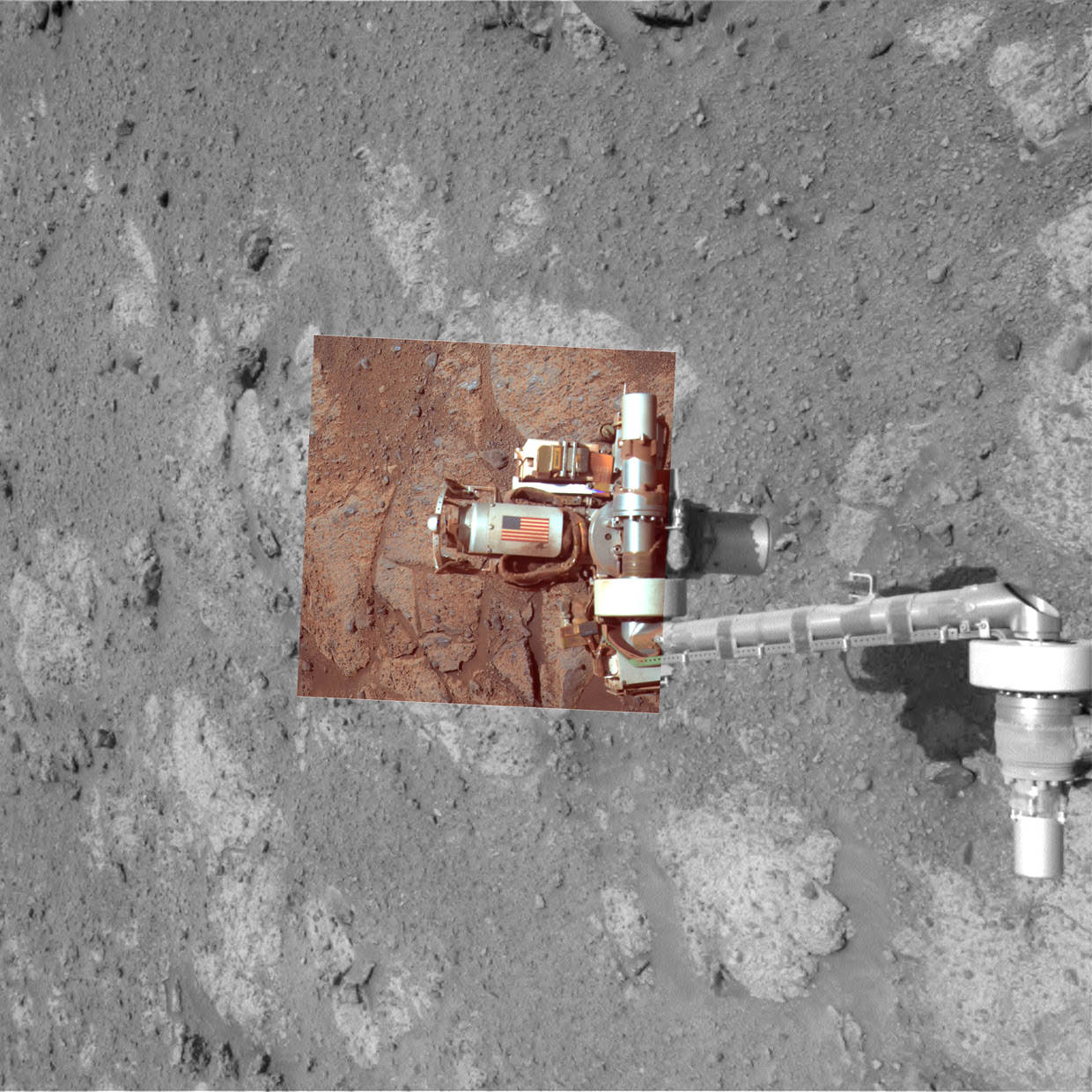
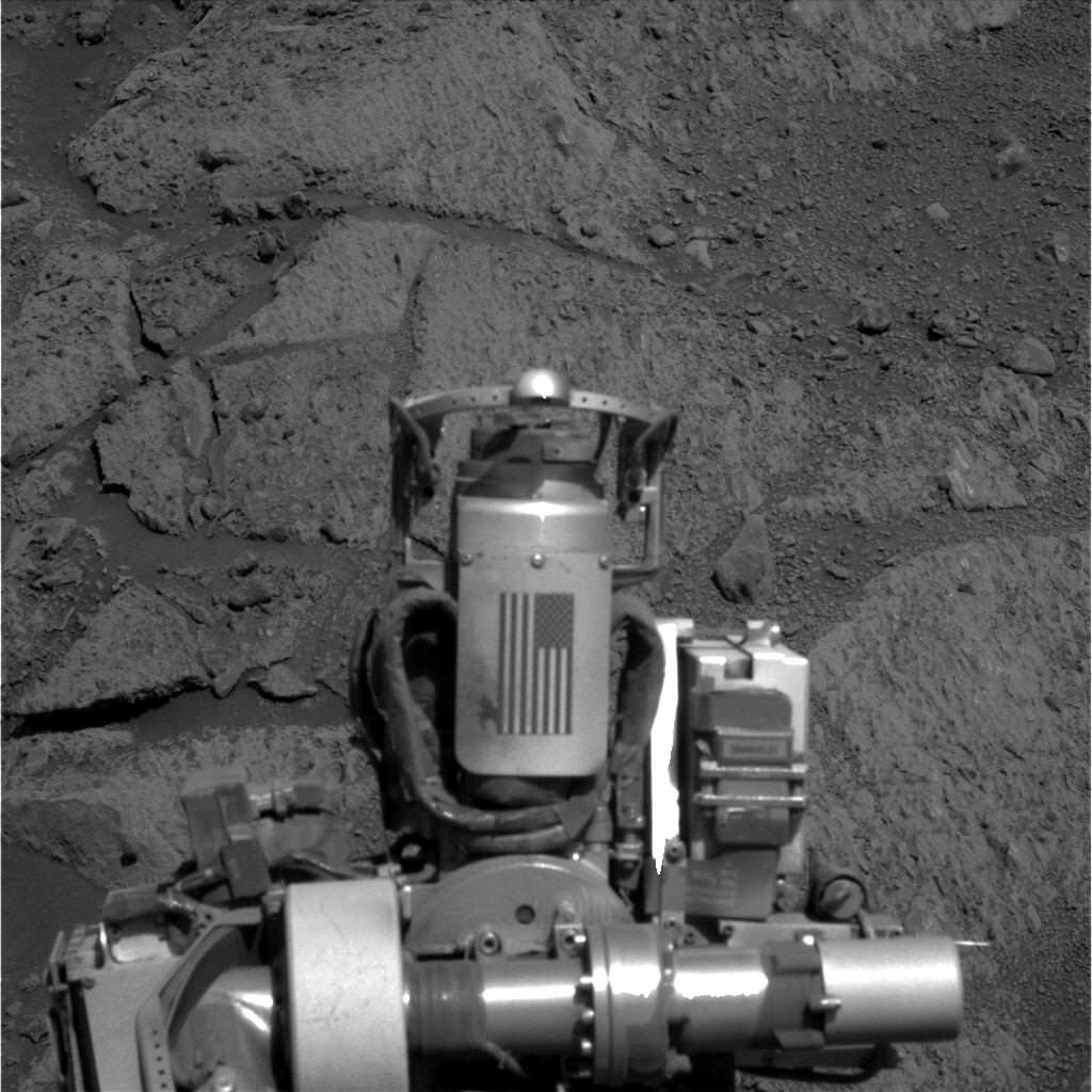
Memorial Image Taken on Mars on Sept. 11, 2011. This view of an American flag on metal recovered from the site of the World Trade Center towers shortly after their destruction on Sept. 11, 2001, was taken on Mars by NASA’s Opportunity rover on Sept. 11, 2011, the 10th anniversary of the attacks on the towers. Credit: NASA/JPL-Caltech/Cornell University/Arizona State University
[/caption]
On this somber occasion marking the 10th anniversary of the tragic events of 9/11, NASA’s Opportunity Mars rover has taken new images of itself on 9/11/11 showing a piece of metal recovered from the wreckage of the Twin Towers of the World Trade Center in New York City that was carried all the way to the planet Mars as a commemorative memorial to the innocent victims of the terrorist attacks of Sept 11, 2001.
On Sept. 11, 2011 (Martian Sol 2713), Opportunity snapped the memorial image above showing the Rock Abrasion Tool (RAT) and an American Flag – evoking the memory of the Twin Towers – from a slope on a Martian hill named Cape York which in turn is a segment of the rim of a gigantic crater named Endeavour.
Opportunity is still roving the red planet’s surface, nearly 8 years after safely landing on Jan 24, 2004. After an epic trek she recently arrived at the gigantic 14 mile wide Endeavour crater .
Opportunity took the new image of the RAT and 9/11 US Flag memorial on Mars on the exact day timed to coincide with the 10th anniversary of the attacks.
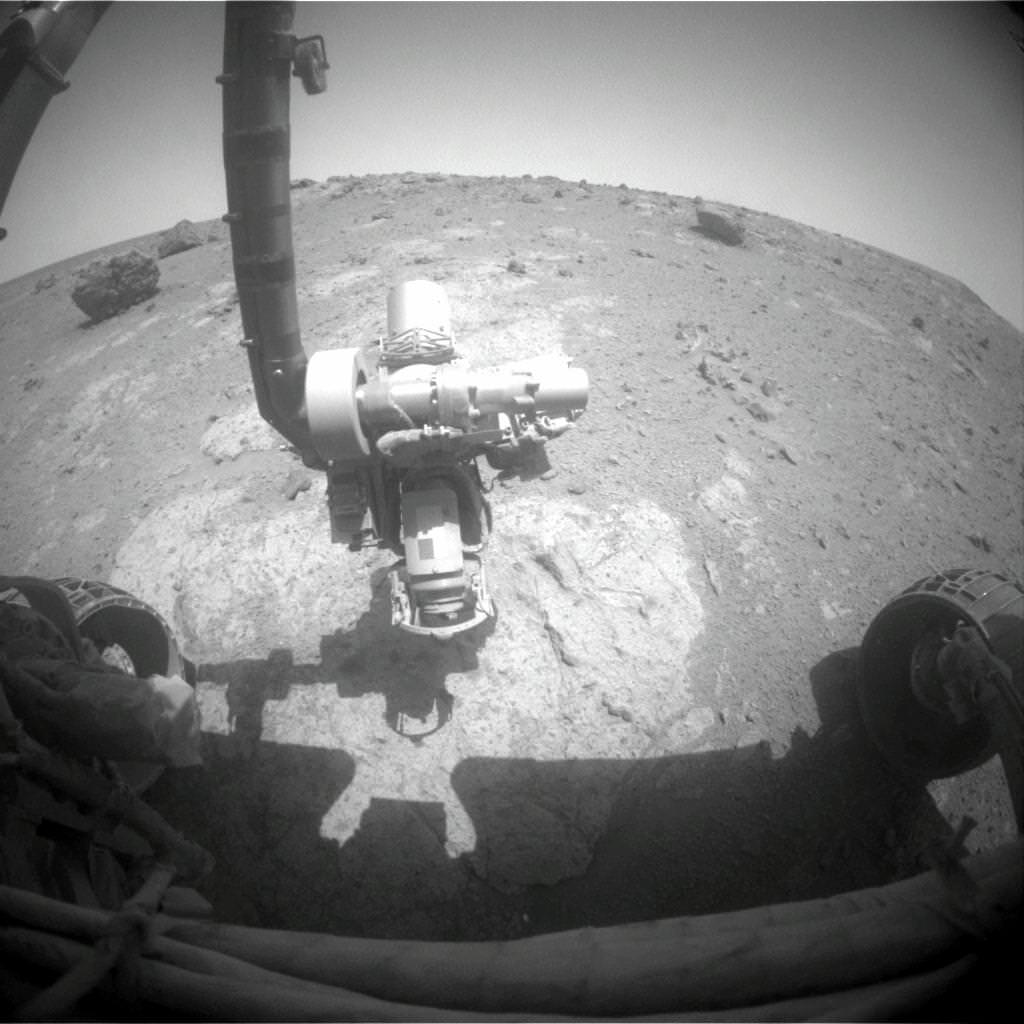
The image shows the arm extended for inspection of target on a rock called “Chester Lake”, according to NASA officials. Opportunity is driving in a northerly direction up the Cape York hill on her scientific expedition of the crater’s rim.
Memorial Close-up Image Taken on Mars on Sept. 11, 2011
Close-up image taken on 9/11/11 of a piece of metal with the American flag on it of a NASA’s Opportunity rover on Mars is made of aluminum recovered from the site of the World Trade Center towers in the weeks after their destruction on Sept. 11, 2001. Credit: NASA/JPL-Caltech/Cornell University/Arizona State University
Both towers of the World Trade Center in New York City were destroyed by the terrorists on that terrible day and nearly 3000 precious people were killed during horrifying historic events that changed America and the World forever.
The RAT was built for NASA and both rovers by Honeybee Robotics which at that time was located less than a mile away from the WTC near the southern tip of Manhattan.
Steve Gorevan, the founder and chairman of Honeybee and a member of the rover science team, told me in a past interview that he was on his way to work and out on the city streets within a few blocks of the Twin Towers when he suddenly heard the sounds of the jet engines just before the first tower was struck.
Gorevan and the Honeybee employees watched the tragic events unfold from their company’s offices and rooftop the rest of the day. Following the terror attacks, Gorevan said access to Honeybee was restricted for weeks and the firm was on a tight deadline to deliver the RAT’s to NASA and the Jet Propulsion Laboratory in California where the rovers were being assembled.
The idea for somehow placing a Martian memorial on the rovers was presented. Gorevan told me that he was able to secure metallic pieces from the WTC wreckage through the Office of the then NYC Mayor Rudy Guiliani a few weeks after the attacks.
Memorial Image Taken on Mars on Sept. 11, 2011 of Robotic Arm at Work showing US Flag 9/11 Memorial on the Rock Abrasion Tool (RAT). Image taken on Sol 2713 as the robot investigates a rock outcrop called Chester Lake. Credit: NASA/JPL-Caltech
Aluminum shards were delivered by the Mayor’s office to Honeybee along with a note indicating their authenticity. These were soon fashioned into an aluminum shield that was placed on each RAT along with a US Flag. The shield serves as a cable guard.
Gorevan says the twin towers memorial was purposely kept quiet for some time until well after both rovers landed out of respect for the victims’ families.
Opportunity is healthy and continuing her exploration of Endeavour crater which harbors geologic formations and rocks unlike any previously investigated by either of the Mars Exploration (MER) rovers.
Along the rim of Endeavour crater rover scientists hope to discover and analyze clay minerals which formed in pH neutral water billions of years ago and a habitable environment much more favorable to the formation of life compared to all the other spots studied by either rover thus far.
Both rovers far exceeded their original 90 days warranties with many years of added bonus time for science exploration.
Endeavour Crater Panorama from Opportunity, Sol 2681, August 2011
Opportunity arrived at the rim of Endeavour on Sol 2681, August 9, 2011 and climbed up the ridge known as Cape York. Odyssey crater is visible at left. Opportunity drove north from here to snap a new 9/11 memorial image on Sept 11, 2011 marking the 10th anniversary of the 9/11 terrorist attacks.
Mosaic Credit: NASA/JPL/Cornell/Marco Di Lorenzo/Kenneth Kremer