Dr. Ken Kremer is a speaker, research scientist, freelance science journalist (KSC area,FL) and photographer whose articles, space exploration images and Mars mosaics have appeared in magazines, books, websites and calendars including Astronomy Picture of the Day, NBC, FOX, BBC, SPACE.com, Spaceflight Now, Science and the covers of Aviation Week & Space Technology, Spaceflight and the Explorers Club magazines. Ken has presented at numerous educational institutions, civic & religious organizations, museums and astronomy clubs. Ken has reported first hand from the Kennedy Space Center, Cape Canaveral, NASA Wallops, NASA Michoud/Stennis/Langley and on over 80 launches including 8 shuttle launches. He lectures on both Human and Robotic spaceflight - www.kenkremer.com. Follow Ken on Facebook and Twitter
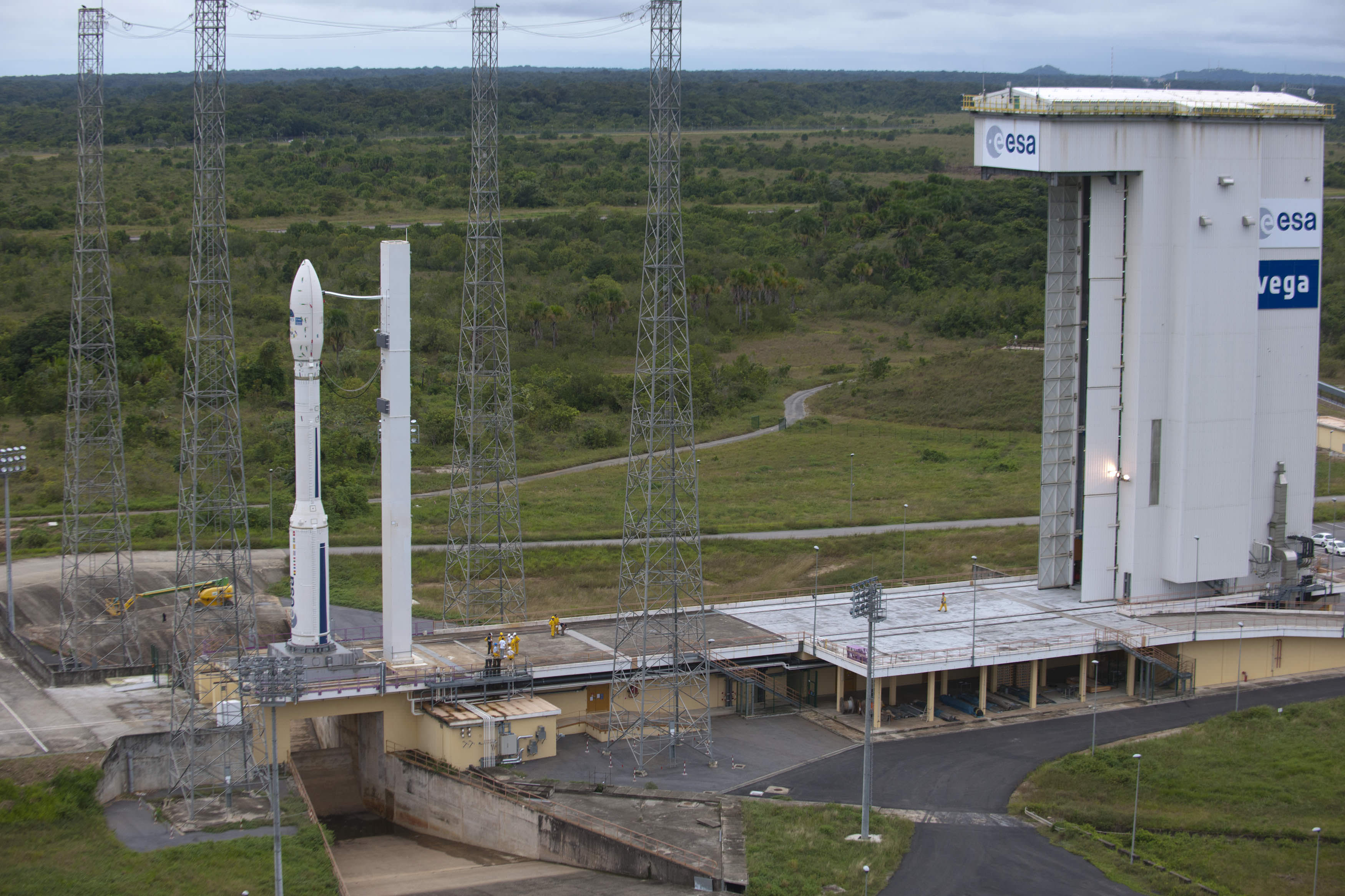
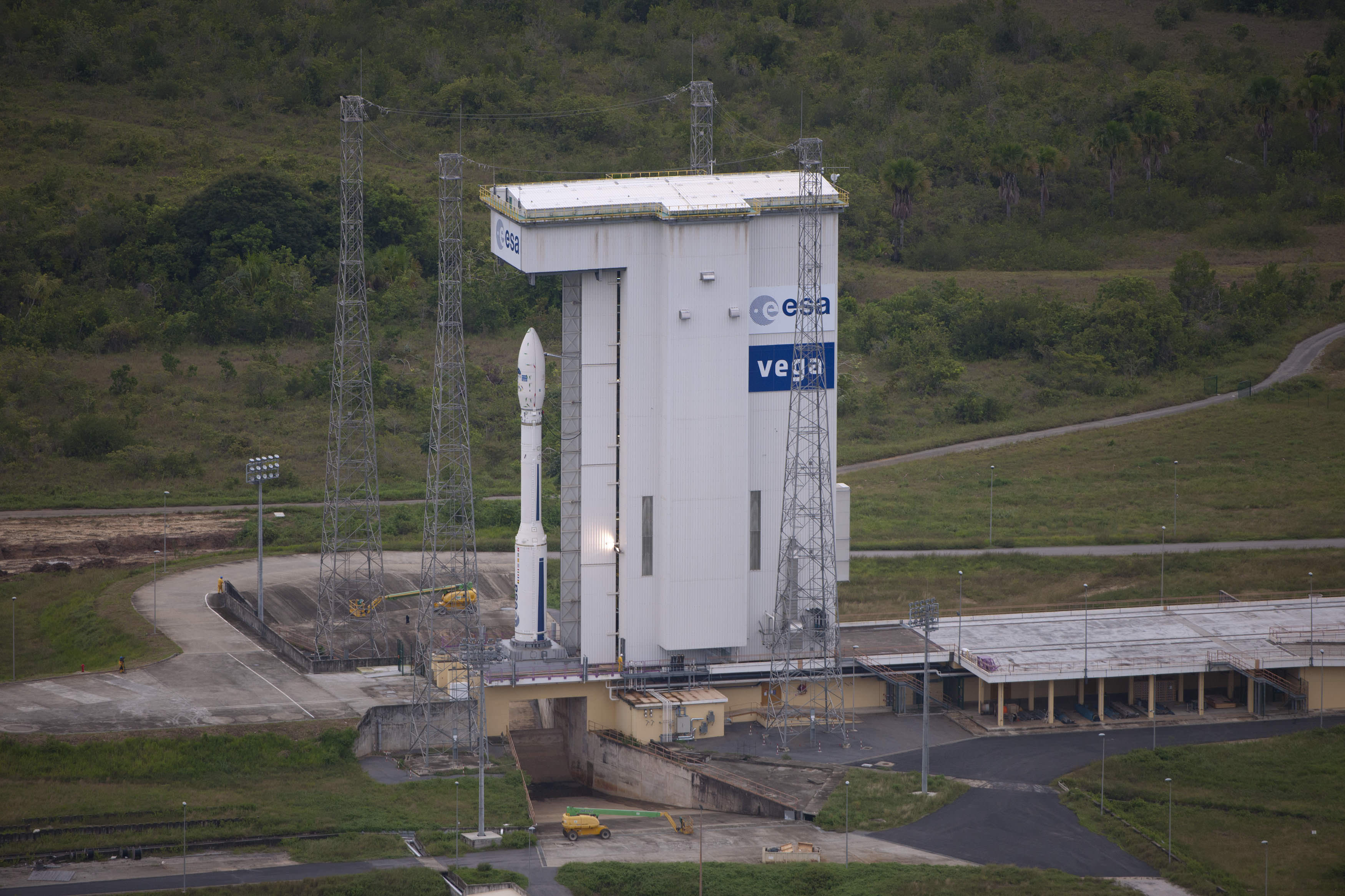
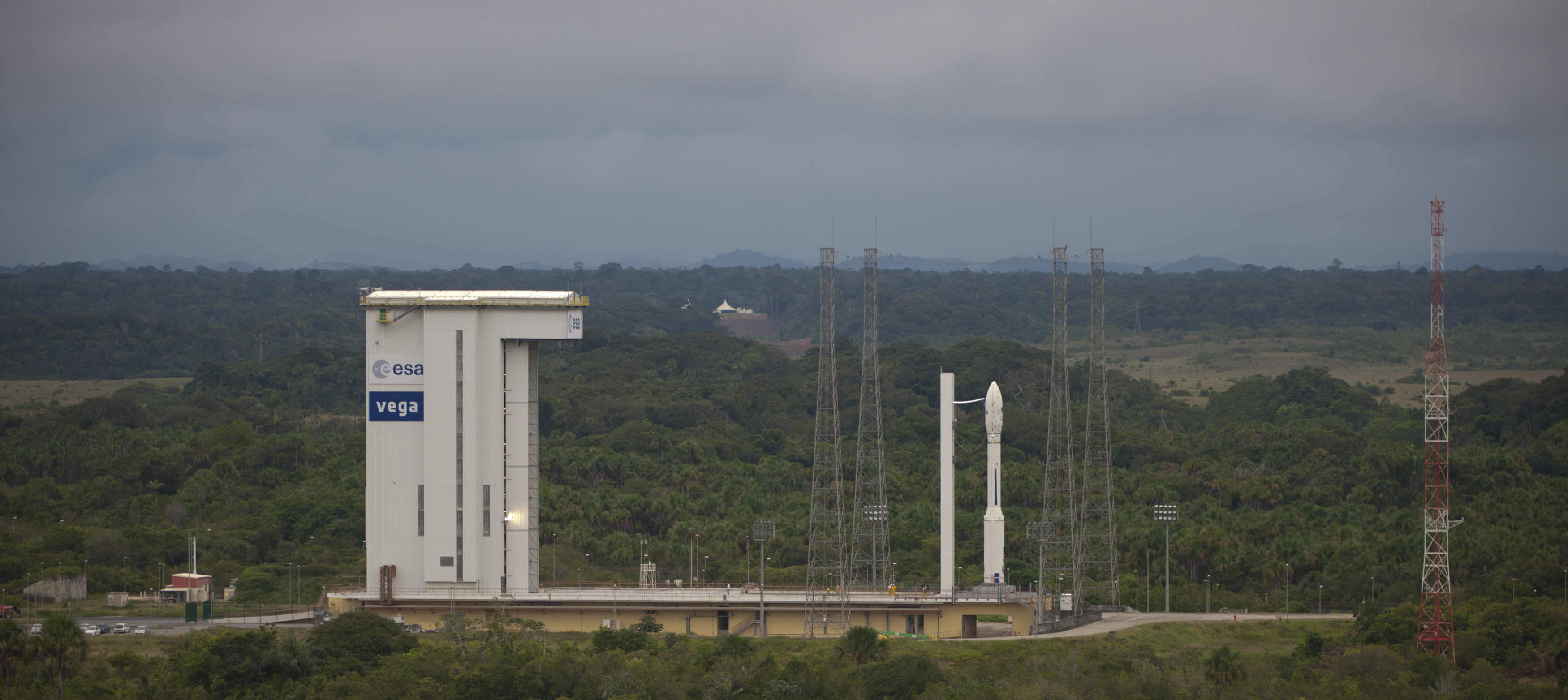
1st Fully assembled Vega on launch pad for Inaugural Flight - February 2012. ESA’s new Vega rocket is now fully assembled on its launch pad. Final preparations are in full swing for the rocket’s inaugural flight as early as February 9 from Europe’s Spaceport in Kourou, French Guiana. Credits: ESA - S. Corvaja
[/caption]
Final preparations are in full swing for the inaugural flight of Europe’s new light launcher – the Vega booster – from the European Space Agency’s (ESA) Spaceport in Kourou, French Guiana. Launch crews are preparing the new rocket for blastoff as early as Feb 9, 2012 from the new Vega launch site at Kourou.
Vega has been under development for 9 years by ESA and its partners, Italian space agency ASI, French space agency CNES and industry.
The 30 meter tall Vega will join ESA’s venerable Ariane rocket family and the newly inaugurated Soyuz as the third class of booster rockets to launch from ESA’s rapidly expanding South American Spaceport at the Guiana Space Center.
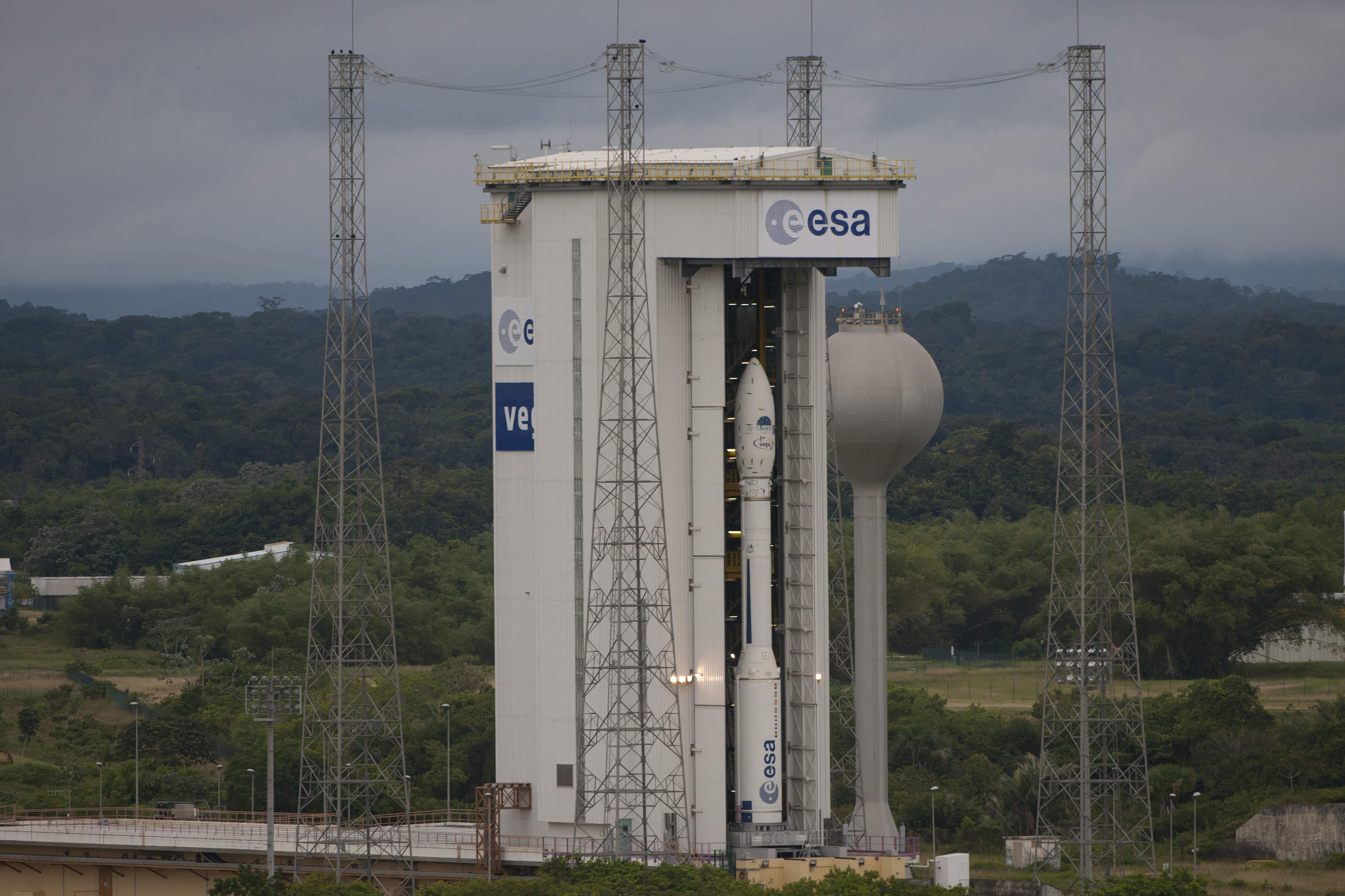
1st Vega Rocket at pad. Credits: ESA - S. Corvaja, 2012
This gives ESA an enormous commercial leap and wide ranging capability to launch all types of satellites from small to big and heavy.
The 4 stage Vega rocket is now fully assembled at the launch pad for the initial qualification flight dubbed VV1. The launch window stretches for a few days beyond Feb. 9.
The Vega VV1 qualification flight will carry 9 satellites to orbit.
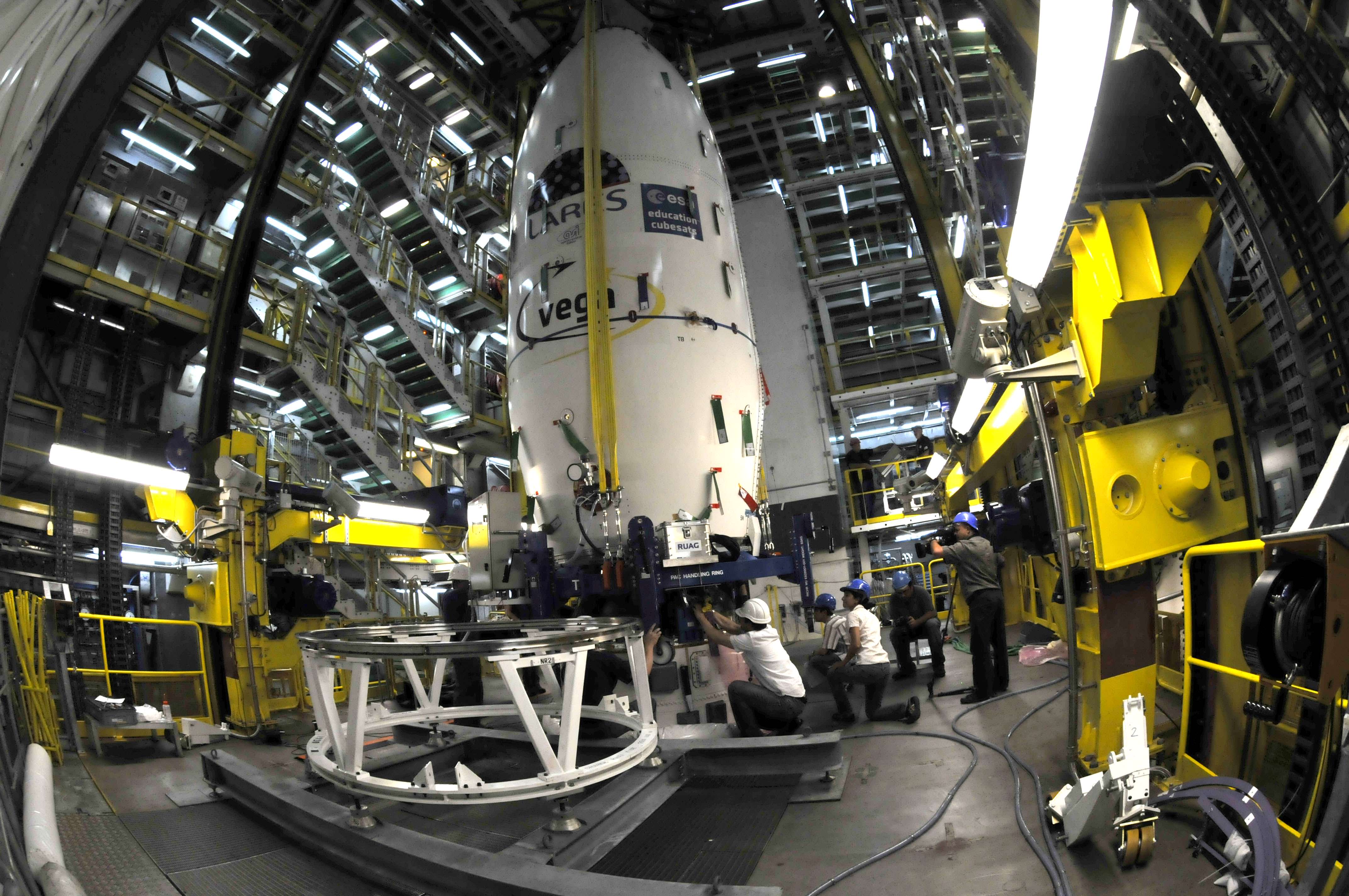
The payloads are housed inside the ‘upper composite’ composed of the payload fairing and adapter and were integrated on top of the AVUM fourth stage by pad workers on Jan. 24, who completed and verified all the electrical and mechanical connections and links.
Fully assembled Vega VV01 on pad. Credits: ESA - S. Corvaja, 2012
The satellites aboard include the LARES laser relativity satellite, ALMASat-1 from ASI and seven CubeSats from an assortment of European Universities.
Vega's upper composite, comprising LARES, ALMASat-1, seven CubeSats and the fairing, was transferred to the pad on 24 January and added to the vehicle at Europe's Spaceport in French Guiana. Credits: ESA - M. Pedoussaut, 2012
The main tasks remaining before the maiden flight are the final checkout of the assembled vehicle, the last launch countdown rehearsal and the fuelling of the restartable AVUM 4th stage with liquid propellants.
The Vega launch site is located at the previous ELA-1 complex, originally used for Ariane 1 and Ariane 3 missions and has been rebuilt and upgraded.
Fully assembled Vega VV01 on pad. Credits: ESA - S. Corvaja, 2012
The Vega rocket is specifically designed to fill a market gap in ESA’s satellite launch capabilities, namely the smaller, lightweight science and earth observation satellites.
It can launch payloads ranging from 300 kg to 2500 kg in mass, depending on the customers orbital requirements.
Vega affords ESA full market coverage by complementing the medium and heavy weight payload categories covered by the Soyuz and Ariane V rockets.
1st Fully assembled Vega on launch pad for Inaugural Flight - February 2012. Credits: ESA - S. Corvaja
Watch Universe Today for Vega maiden launch coverage and special launch pictures
Western Europe at Night With hardware from the Earth-orbiting International Space Station appearing in the near foreground, a night time European panorama reveals city lights from Belgium and the Netherlands at bottom center. the British Isles partially obscured by solar array panels at left, the North Sea at left center, and Scandinavia at right center beneath the end effector of the Space Station Remote Manipulator System or Canadarm2. This image was taken by the station crew on Jan. 22, 2012. Credit: NASA
[/caption]
An amazing panorama revealing Western Europe’s ‘Cities at Night’ with hardware from the stations robotic ‘hand’ and solar arrays in the foreground was captured by the crew in a beautiful new image showing millions of Earth’s inhabitants from the Earth-orbiting International Space Station (ISS).
The sweeping panoramic vista shows several Western European countries starting with the British Isles partially obscured by twin solar arrays at left, the North Sea at left center, Belgium and the Netherlands (Holland) at bottom center, and the Scandinavian land mass at right center by the hand, or end effector, of the Canadian-built ISS robotic arm known as the Space Station Remote Manipulator System (SSRMS) or Canadarm2.
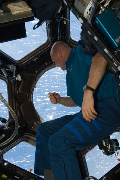
European Space Agency astronaut Andre Kuipers gazing at Earth from the Cupola dome of the ISS
Coincidentally European Space Agency astronaut Andre Kuipers from Holland (photo at left) is currently aboard the ISS, soaring some 400 kilometers (250 miles) overhead.
The panoramic image was taken by the ISS residents on January 22, 2012.
The Expedition 30 crew of six men currently serving aboard the ISS (photo below) hail from the US, Russia and Holland.
“Cities at Night” – Here’s a portion of a relevant ISS Blog post from NASA astronaut Don Pettit on Jan. 27, 2012:
“Cities at night are different from their drab daytime counterparts. They present a most spectacular display that rivals a Broadway marquee. And cities around the world are different. Some show blue-green, while others show yellow-orange. Some have rectangular grids, while others look like a fractal-snapshot from Mandelbrot space.”
“Patterns in the countryside are different in Europe, North America, and South America. In space, you can see political boundaries that show up only at night. As if a beacon for humanity, Las Vegas is truly the brightest spot on Earth. Cities at night may very well be the most beautiful unintentional consequence of human activity,” writes NASA astronaut Don Pettit currently residing aboard the ISS.
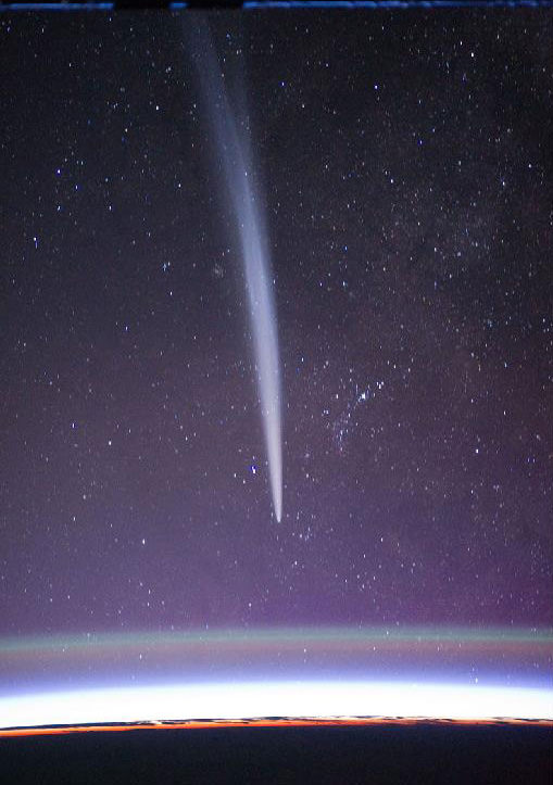
Comet Lovejoy on 22 Dec. 2011 from the International Space Station. Comet Lovejoy is visible near Earth’s horizon in this nighttime image photographed by NASA astronaut Dan Burbank, Expedition 30 commander, onboard the International Space Station on Dec. 22, 2011. Credit: NASA/Dan BurbankExpedition 30 Crew: Pictured on the front row are NASA astronaut Dan Burbank, commander; and Russian cosmonaut Oleg Kononenko, flight engineer. Pictured from the left (back row) are Russian cosmonauts Anton Shkaplerov and Anatoly Ivanishin; along with European Space Agency astronaut Andre Kuipers and NASA astronaut Don Pettit, all flight engineers. Photo credit: NASA and International Space Station partners
Toronto Teens Launch Lego Main In Space to the Stratosphere - Jan 2012. Stunning space imagery was captured by Canadian teenagers Mathew Ho and Asad Muhammad when they lofted a tiny ‘Lego Man in Space’ astronaut to an altitude of 16 miles (25 kilometers) using on a helium filled weather balloon. Credit: Mathew Ho and Asad Muhammad. Watch the YouTube below
[/caption] Updated:Jan. 30
Two teens from Toronto,Canada have launched “Lego Man in Space” using a helium filled weather balloon and captured stunning video of the miniature toy figure back dropped by the beautiful curvature of Earth and the desolate blackness of space that’s become a worldwide YouTube sensation – over 2 million hits !
17 year olds Mathew Ho and Asad Muhammad lofted the tiny 2 inch tall Lego figure from a local Toronto soccer field up to a height of about 85,000 feet, or 16 miles (25 kilometers), where the 22 foot (7 m) diameter helium balloon burst in what is technically known as the stratosphere. The homemade styrofoam capsule – equipped with two video cameras and two digital cameras (Canon) – then parachuted back to Earth.
“We launched the project on January 7,” Mathew Ho told Universe Today.
“Altogether, we used 4 cameras, two cameras taking stills, and two taking video – Canon, Sony, GoPro – in the 1 cubic foot capsule,” Ho explained.
“After endless hours of hard work, we managed to capture stunning views of our atmosphere and put a ‘Lego’ man into near space!” said the ambitious teens who are 12th graders at the Agincourt Collegiate Institute.
The pair posted a YouTube video (below) documenting the entire voyage and some camera snapshots on their website on January 25.
Lego Man even snapped cool Moon shots – look closely at the video and photo below.
“Lego Man in Space” – The Video
The duo recounted the details of their sensational space tale of science on a shoestring for Canadian TV and newspapers.
“Upon launch we were very relieved. But we had a lot of anxiety on launch day because there were high winds when we were going up after all the hard work,” said Ho in a studio interview on Canadian TV (CTV).
“We were also scared because now we would have to retrieve it back after it came down,” Asad chimed in.
“We had no idea it would capture photos like that and would be so good,” said Ho. “We were blown away when we saw them back home.”
The toy Lego astronaut is seen standing atop a thin runway protruding precariously from one end of the small, box shaped capsule as though he was walking the plank and about to plunge into the ocean of space. All the while, cameras were aimed directly out towards him recording the entire rollicking journey from liftoff to the stratosphere to landing, with a constantly changing Earth in the background.
Altogether they netted two videos and 1500 photos.
Lego Man in Space shoots the Moon !
Credit: Mathew Ho and Asad Muhammad
Coincidentally, several Lego toys are constantly flying even higher above the Earth at this very moment aboard the International Space Station as part of an educational outreach effort by NASA and Lego. And 3 more Lego figurines are speeding to Jupiter aboard NASA’s Juno orbiter.
Legoman’s spectacular journey lasted some 97 minutes. He’s beaming proudly throughout the video while holding the Canadian National flag – the Red Maple Leaf. The rollercoaster-like scenery may well challenge the stomachs of those with fear of heights.
The tumbling Lego Man in Space capsule upon the violent descent captured the moment before the parachute was activated. Credit: Mathew Ho and Asad Muhammad
Mathew and Asad worked over about four months one day a week on Saturdays to assemble the rig in Mathew’s kitchen and successfully accomplished the feat on a shoestring budget of merely 400 dollars. They used GPS trackers to locate “Lego Man in Space” and recover the intact capsule holding the imagery.
After the balloon burst at 85,000 feet, the parachute assisted descent back to Earth took about 32 minutes. Winds aloft caused the capsule to drift some 76 miles (122 kilometers) away from the launch site before landing at Rice Lake in one piece.
Lego Man in Space capsule after landing 76 miles (122 kilometers) away from the Toronto soccor field launch site. Credit: Mathew Ho and Asad Muhammad
“We were jumping for joy when we saw the capsule and the parachute. We were ecstatic when we found it,” said Ho.
“We have a long history of passionate building and working together,” Ho told CTV.
The project began after they saw that MIT students had sent a camera to the edge of space with a balloon and captured stunning views.
“We were inspired by videos and pictures we had seen online two years ago and we began working on this in the Fall of 2011. In total the project cost about $400 Canadian,” Ho told me.
“We hope to publish more pictures and video to our Facebook page and website soon,” Ho added.
And now we know another truth about Lego’s – Not only can they withstand the destructive forces of kids, but outer space too !
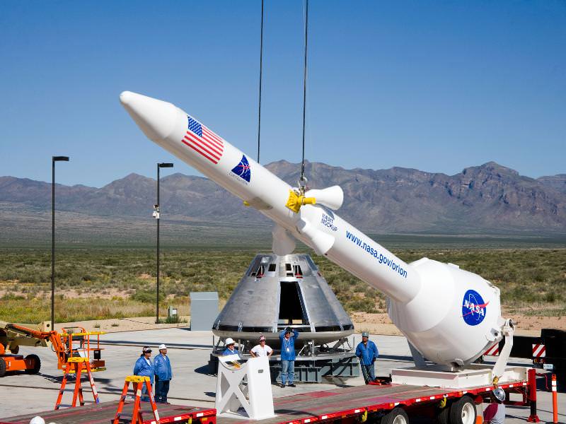
Orion Test Capsule at Practice for Pad Abort 1 Test. The Orion test capsule is now on a cross country tour from New Mexico to Florida with stops in Oklahoma, Texas and Alabama. Ground teams in White Sands, New Mexico, practice stacking test versions of Orion and its launch abort system. This was being done in advance of Orion’s launch abort system test. Credit: NASA or National Aeronautics and Space Administration
[/caption]
Here’s your chance for a birds-eye view of an Orion capsule, up-close and personal ! Catch it if you can !
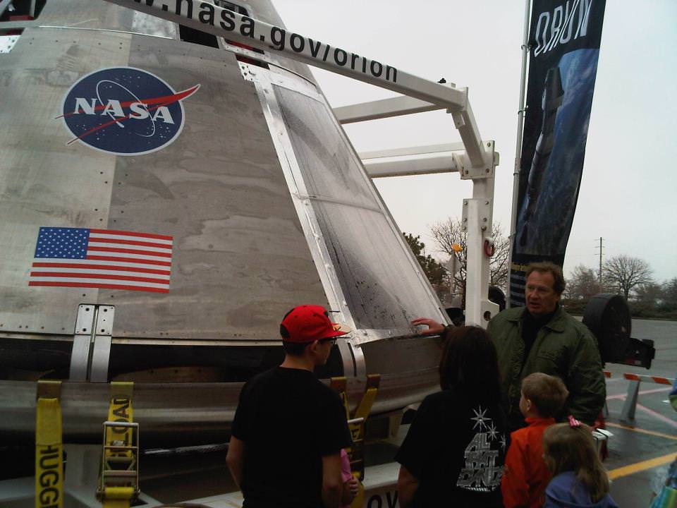
A full scale test version of one of NASA’s Orion spacecraft has embarked on a cross country tour from White Sands, New Mexico, across several states in the southern United States that ultimately lands at the Kennedy Space Center in Florida.
Starting today, Jan. 27, an Orion spacecraft is open for viewing by the public in Texas at Victory Park and the American Airlines Center in Dallas.
Orion fans in Texas
The Coopers from Southlake meet NASA astronaut Nick Patrick by the Orion crew module now on display at the American Airlines Center in Dallas, TX.
The display continues throughout this weekend after a well received visit to Oklahoma at the Science Museum Oklahoma in Oklahoma City.
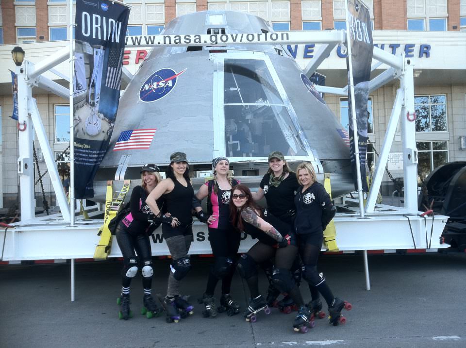
Roller Derby team visits Orion test capsule now on public display in Texas
The next stop on the cross country journey is the U.S. Space and Rocket Center in Huntsville, Ala on Feb 1-2.
Orion is NASA’s next generation human spaceflight vehicle that will eventually replace the space shuttle and loft astronauts to low Earth orbit and beyond to deep space destinations such as the Moon, Asteroids and Mars. It can also dock at the International Space Station (ISS).
The Orion crew module journey is a wonderful and fun opportunity for individuals and families to see real space exploration hardware with your own eyes and learn all about the goals and plans of the US Space Program and your investment in it as a taxpayer.
Knowledgeable Orion experts will be on hand to speak with visitors in easy to understand ways. This includes astronauts, engineers, program officials and press spokespeople from NASA, Lockheed-Martin (Orion prime contractor) and other companies involved in building the Orion capsule and other components that will rocket the vehicle to orbit.
Veteran NASA Astronauts Nick Patrick and Clay Anderson will be on hand at the Dallas stop. NASA Astronauts Doug Hurley and Jim Dutton will attend the Alabama display.
Hurley was the pilot for the final shuttle mission by Space Shuttle Atlantis for the STS-135 mission to the International Space Station.
Orion fans in Oklahoma. Credit: NASA
The Orion tour also includes colorful and informative display panels and fun kids activities that I’ve personally witnessed on several occasions. In past years the Orion Launch Abort System (LAS) engaged in similar trips.
This Orion test vehicle was used by ground crews preparing for the PA-1 launch abort system flight test that took place in New Mexico in 2010.
The first orbital flight test of an unmanned Orion is scheduled for 2014 atop a Delta 4 Heavy booster..
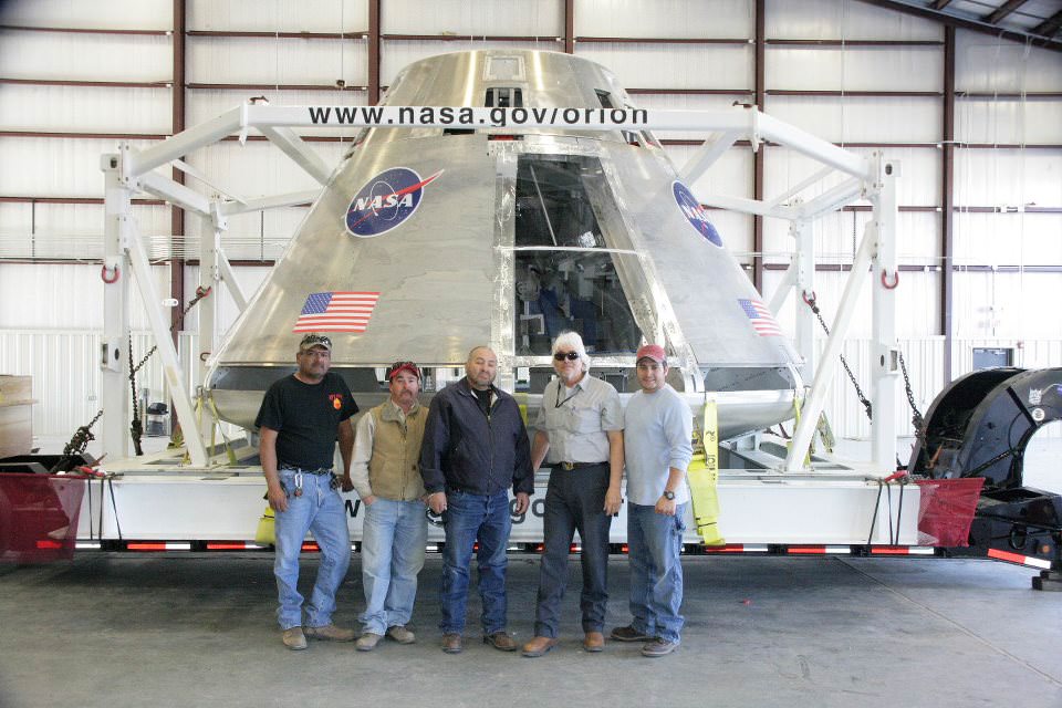
Orion fans in Dallas, Texas - Mike, Darnell and AkeemOrion Test capsule with test facility workers at White Sands Facility, New Mexico. Credit: NASA
Look here for more information on the Orion stops in Texas and Alabama
American Airlines Center: http://www.americanairlinescenter.com/
U.S. Space and Rocket Center: http://www.ussrc.com/
NASA’s future has suddenly become a hot topic in the GOP Presidential Debates. Orion is at the center of that debate on whether Americans will ever return to the Moon.
This is your opportunity to see history in the making
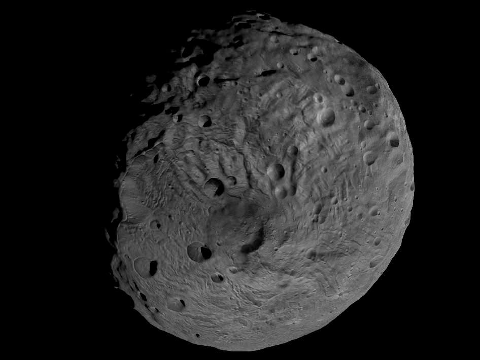
Viewing the South Pole of Vesta and Rhea Silvia Impact Basin. This image obtained by Dawn’s framing camera shows the south pole of the giant asteroid Vesta and the circular Rheasilvia impact basin which scientists believe originated by a collision with another asteroid early in the asteroid's history. The image was recorded from a distance of about 1,700 miles (2,700 kilometers). The image resolution is about 260 meters per pixel. Credit: NASA/JPL-Caltech/UCLA/MPS/DLR/IDA
[/caption]
The mysterious asteroid Vesta may well have more surprises in store. Despite past observations that Vesta would be nearly bone dry, newly published research indicates that about half of the giant asteroid is sufficiently cold and dark enough that water ice could theoretically exist below the battered surface.
Scientists working at NASA’s Goddard Space Flight Center in Greenbelt, Md., and the University of Maryland have derived the first models of Vesta’s average global temperatures and illumination by the Sun based on data obtained from the Hubble Space Telescope.
“Near the north and south poles, the conditions appear to be favorable for water ice to exist beneath the surface,” says Timothy Stubbs of NASA’s Goddard Space Flight Center in Greenbelt, Md., and the University of Maryland, Baltimore County. The research by Timothy Stubbs and Yongli Wang, of the Goddard Planetary Heliophysics Institute at the University of Maryland, was published in the January 2012 issue of the journal Icarus.
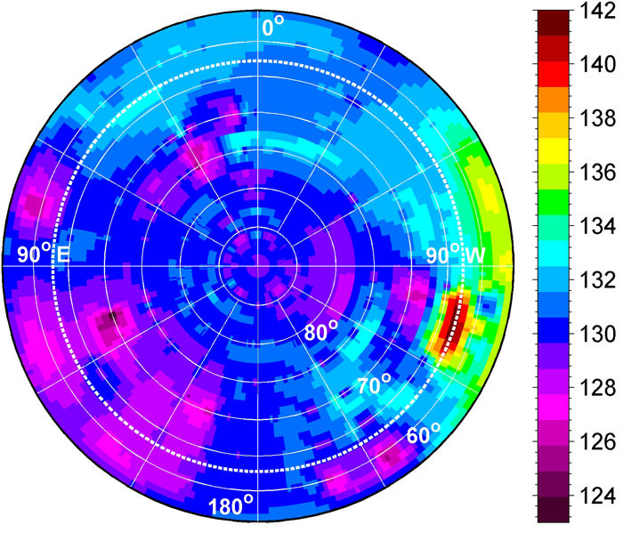
If any water lurks beneath Vesta, it would most likely exist at least 10 feet (3 meters) below the North and South poles because the models predict that the poles are the coldest regions on the giant asteroid and the equatorial regions are too warm. Global Map of Average Surface Temperature of Vesta
This global map of average surface temperature shows the warmer equatorial zone of the giant asteroid Vesta is likely too warm to sustain water ice below the surface. But roughly half of Vesta is so cold and receives so little sunlight on average that water ice could have survived there for billions of years. The dividing lines (solid gray) are found at about 27 degrees north latitude and 27 degrees south latitude. This map, with temperatures given in kelvins, comes from the first published models of the average global temperature and illumination conditions on Vesta. Credit: NASA/GSFC/UMBC
If proven, the existence of water ice at Vesta would have vast implications for the formation and evolution of the tiny body and upend current theories.
The surface of Vesta is not cold enough for ice to survive all the time because unlike the Moon, it probably does not have any significant permanently shadowed craters where water ice could stay frozen on the surface indefinitely.
Even the huge 300 mile diameter (480-kilometer) crater at the South Pole is not a good candidate for water ice because Vesta is tilted 27 degrees on its axis, a bit more than Earth’s tilt of 23 degrees.
By contrast, the Moon is only tilted 1.5 degrees and possesses many permanently shadowed craters. NASA’s LCROSS impact mission proved that water ice exists inside permanently shadowed lunar craters.
New modeling shows that, under present conditions, Vesta's polar regions are cold enough (less than about 145 kelvins) to sustain water ice for billions of years, as this map of average surface temperature around the asteroid's south pole indicates.
The models predict that the average annual temperature around Vesta’s poles is below minus 200 degrees Fahrenheit (145 kelvins). Water ice is not stable above that temperature in the top 10 feet of Vestan soil, or regolith.
At the equator and in a band stretching to about 27 degrees north and south in latitude, the average annual temperature is about minus 190 degrees Fahrenheit (145 kelvins), which is too high for the ice to survive.
“On average, it’s colder at Vesta’s poles than near its equator, so in that sense, they are good places to sustain water ice,” says Stubbs in a NASA statement. “But they also see sunlight for long periods of time during the summer seasons, which isn’t so good for sustaining ice. So if water ice exists in those regions, it may be buried beneath a relatively deep layer of dry regolith.”
Vesta is the second most massive asteroid in the main Asteroid belt between Mars and Jupiter.
NASA’s Dawn Asteroid Orbiter is the very first mission to Vesta and achieved orbit in July 2011 for a 1 year long mission.
Dawn is currently circling Vesta at its lowest planned orbit. The three science instruments are snapping pictures and the spectrometers are collecting data on the elemental and mineralogical composition of Vesta.
The onboard GRaND spectrometer in particular could shed light on the question of whether water ice exists at Vesta.
So far no water has been detected, but the best data is yet to come.
In July 2012, Dawn fires up its ion thrusters and spirals out of orbit to begin the journey to Ceres, the largest asteroid of them all.
Ceres is believed to harbor huge caches of water, either as ice or in the form of oceans and is a potential habitat for life.
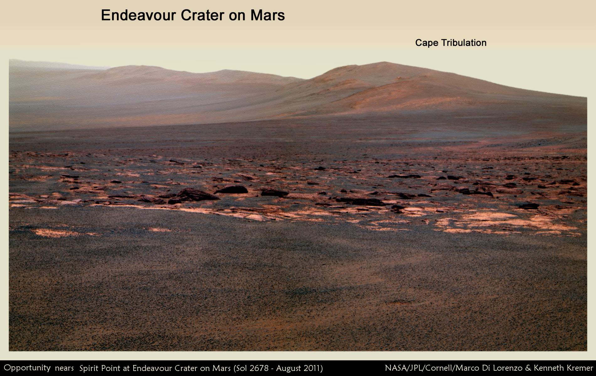
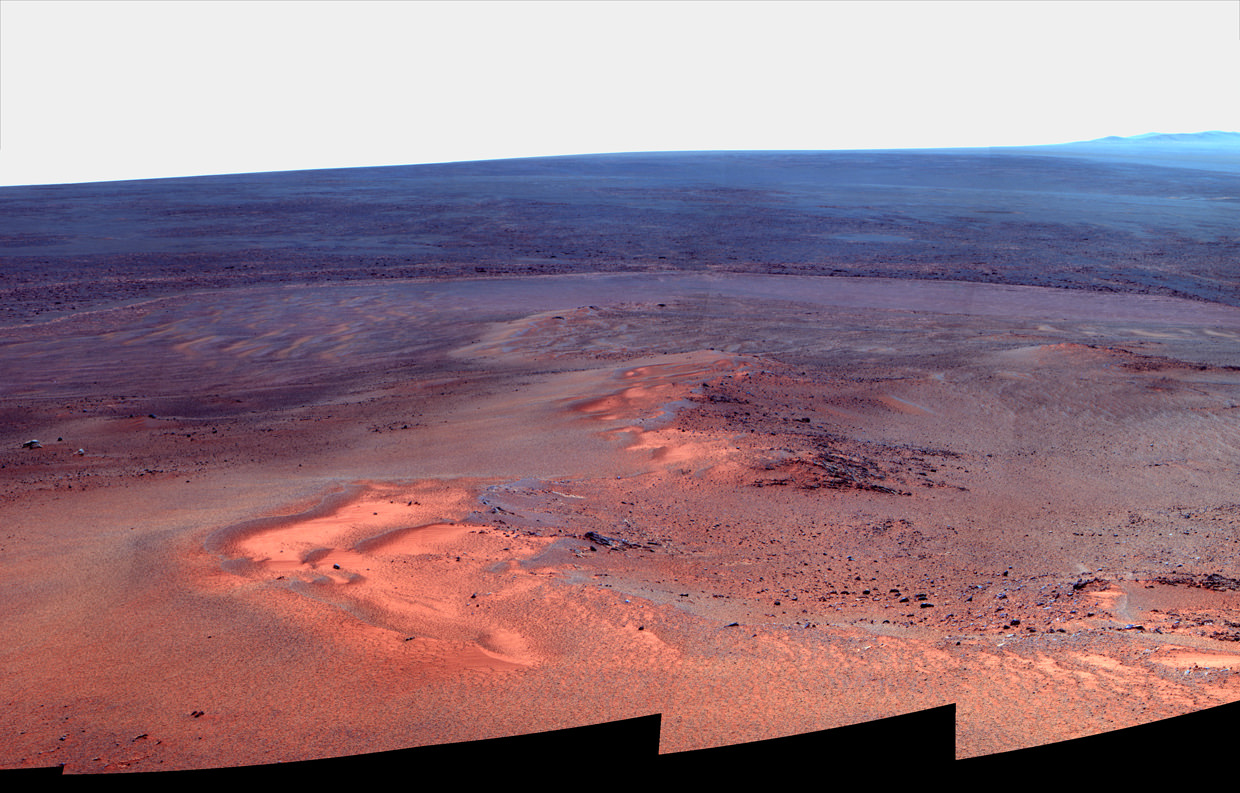
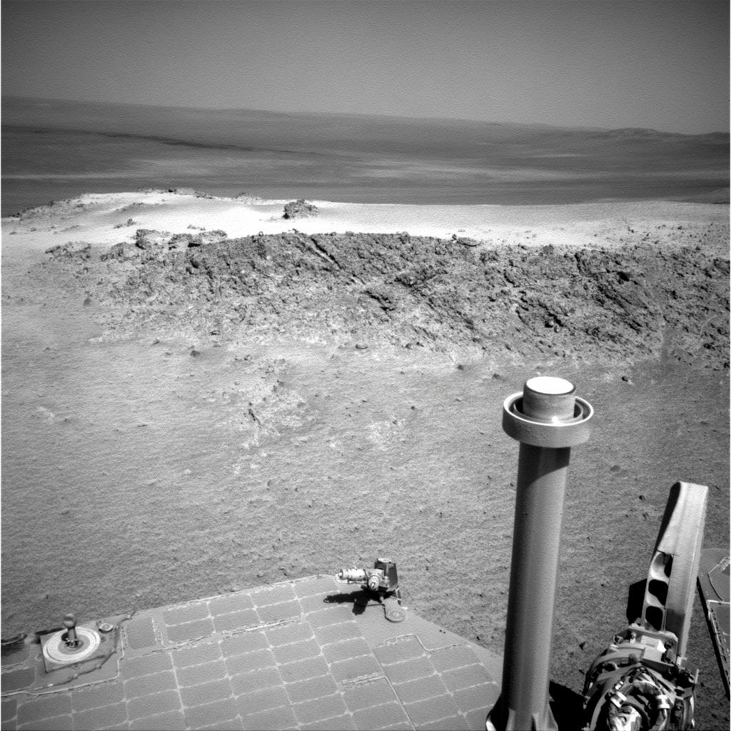
Martian Vista from Opportunity at Endeavour Crater - 8 Years on Mars. NASA’s Opportunity rover celebrated 8 Years on Mars on January 24, 2012. This mosaic shows portions of the segmented rim of Endeavour crater (14 miles, 22 km wide) after the robot arriving at the craters foothills in August 2011. Large ejecta blocks from a smaller nearby crater are visible in the middle. At Endeavour, Opportunity will investigate the oldest minerals deposits she has ever visited from billions of years ago and which may hold clues to environments that were potentially habitable for microbial life. The rover will eventually drive to Cape Tribulation at right after surviving her 5th winter on Mars. Mosaic Credit: NASA/JPL/Cornell/Marco Di Lorenzo/Kenneth Kremer
[/caption]
Today, the resilient Opportunity robot begins her 9th year roving around beautifully Earth-like Martian terrain where potentially life sustaining liquid water once flowed billions of years ago.
Opportunity celebrates her 8th anniversary on the Red Planet gazing at the foothills of the vast crater named Endeavour, promising a “mother lode” of “watery” science – an unimaginable circumstance since the nail biting landing on the hematite rich plains of Meridiani Planum on 24 January 2004.
“Opportunity is 97 months into the 3 month mission,” team members are proud and universally surprised to say.
“Milestones like 8 years on Mars always make me look forward rather than looking back,” Rover Principal Investigator Prof. Steve Squyres of Cornell University told Universe Today for this article commemorating Opportunity’s landing.
“We’ve still got a lot of exploring to do, but we’re doing it with a vehicle that was designed for a 90-sol mission. That means that every sol is a gift at this point.”
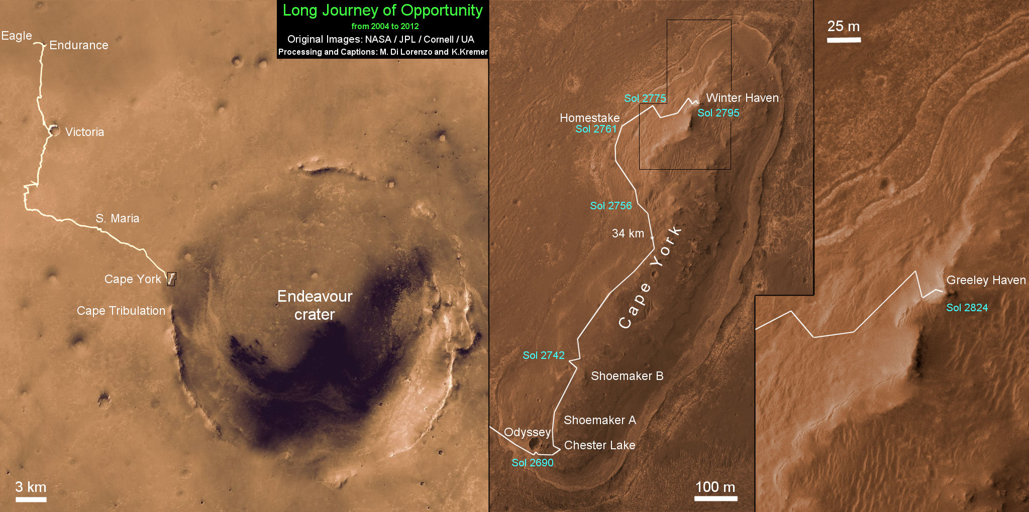
Opportunity has driven more than 21 miles (34 kilometers) across the Red Planet’s surface during what is truly humankind’s first overland expedition on another Planet. See our route map below.
Opportunity Rover Traverse Map at Meridiani Planum on Mars - 2004 to 2012
Traverse map shows the 8 Year Journey of Opportunity from Eagle Crater landing site on Sol 1- Jan. 24, 2004 - to 5th Winter Haven worksite at Greeley Haven at Endeavour Crater rim in January 2012. Opportunity embarked on a crater tour and discovered bountiful evidence for the flow of liquid water on Mars billions of years ago. The robot has shown that ancient ephemeral shallow lakes existed on Mars when the cratered terrain was cut by fluvial channels. Endeavour Crater is 14 miles (22 kilometers) in diameter. Opportunity has so far driven more than 21 miles (34 km) over 8 Years but was only expected to live for 90 Martian days. Credit: NASA/JPL/Cornell/UA/Marco Di Lorenzo/Kenneth Kremer
NASA’s twin rovers Spirit and Opportunity blasted off for Mars atop a pair of Delta II rockets in the summer of 2003 with a mission “warranty” of just 90 Martian days, or Sols.
Today is Sol 2846 of working operations for Opportunity, compared to an anticipated lifetime of only 90 Sols – that amounts to more than 31 times beyond the designer’s expectations.
Indeed, the long lived robot is now enduring her 5th Winter on Mars. And to glimpse the next Martian sunrise, the robo girls manmade components must survive the harsh extremes of frigid Antarctic-like temperatures each and every sol.
“I never thought that we would still be planning sequences for Opportunity today,” Ray Arvidson told Universe Today. Arvidson, of Washington University in St. Louis, is the deputy rover principal investigator.
“I seriously thought both Spirit and Opportunity would be finished by the summer of 2004.”
Opportunity's Eighth Anniversary View From 'Greeley Haven' (False Color). This mosaic of images taken in mid-January 2012 shows the windswept vista northward (left) to northeastward (right) from the location where Opportunity is spending its fifth Martian winter, an outcrop informally named "Greeley Haven. Credit: NASA/JPL-Caltech/Cornell/Arizona State Univ.
But, Opportunity is the gift to science that keeps on giving.
“I am feeling pretty good as the MER rover anniversaries approach,” Arvidson told me.
“Opportunity has shown that ancient ephemeral shallow lakes existed as Mars moved climatically from an early period when the cratered terrain was cut by fluvial channels to the current dry and cold conditions that dominate.”
“Both rovers have conclusively shown the need for lateral mobility to get to relevant outcrops and back out the secrets associated with past conditions,” Arvidson explained.
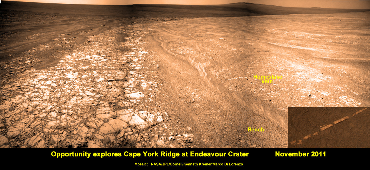
Barely a month ago the bountiful harvest from mobility was once again demonstrated when the science team lead by Squyres and Arvidson announced that Opportunity had discovered the most scientifically compelling evidence yet for the flow of liquid water on ancient Mars.
Squyres and Arvidson announced that Opportunity had found a bright vein – named “Homestake” – composed of the mineral gypsum located at the Cape York segment of Endeavour Crater where the intrepid robot is currently spending her 5th Martian Winter.
“This gypsum vein is the single most powerful piece of evidence for liquid water at Mars that has been discovered by the Opportunity rover,” Squyres explained.
Veins are a geologic indication of the past flow of liquid water.
See our mosaic below illustrating the exact location of the “Homestake” vein at Endeavour Crater – also published at Astronomy Picture of the Day; 12 Dec 2011.
Opportunity discovers Water related Mineral Vein at Endeavour Crater - November 2011
Opportunity rover discovered Gypsum at the Homestake mineral vein, while exploring around the base of Cape York ridge at the rim of Endeavour Crater. The vein is composed of calcium sulfate and indicates the ancient flow of liquid water at this spot on Mars. This panoramic mosaic of images was taken on Sol 2761, November 2011, and illustrates the exact spot of the mineral vein discovery.
Credit: NASA/JPL/Cornell/Kenneth Kremer/Marco Di Lorenzo
Published on Astronomy Picture of the Day (APOD): 12 Dec 2011
Opportunity just arrived at the rim of the 14 mile (22 kilometer) wide Endeavour Crater in mid-August 2011 following an epic three year trek across treacherous dune fields from her prior investigative target at the ½ mile wide Victoria Crater.
“It’s like a whole new mission since we arrived at Cape York,” says Squyres.
For the next few months of the bitterly cold Martian winter, Opportunity will conduct a vigorous science campaign while remaining mostly stationary at a spot dubbed “Greeley Haven” in honor of Prof. Ronald Greeley, a team member from Arizona State University who recently passed away.
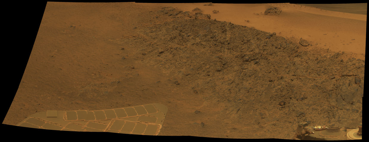
Opportunity Mars Rover at 5th Winter Worksite at Endeavour Crater
This mosaic shows the view of NASA’s Opportunity rover parked at “Greeley Haven” worksite where the robot will spend her 5th Martian Winter. This mosaic of images shows the Winter Haven view from the Cape York Ridge at the western rim of Endeavour Crater looking south along the crater rim. Tire tracks at right. Credit: NASA/JPL/Cornell/ Marco Di Lorenzo/Kenneth Kremer
At this moment Opportunity is snapping a 360 degree panorama, deploying her robotic arm onto nearby outcrops, collecting microscopic images, making measurements of mineral compositions with the Alpha Particle X-Ray Spectrometer and conducting radio science observations to elucidate the unknown structure of the Martian interior and core.
The rover is covered with a significant coating of dust which limits her ability to generate power from the life sustaining solar arrays. Since Opportunity is traversing just south of the equator, engineers have temporarily parked her on a northerly facing slope to maximize the electric power generation.
“Opportunity is currently sitting on an outcrop of impact breccias at Greeley Haven on Cape York,” said Arvidson.
Opportunity will remain at Greeley Haven until some time after the Winter Solstice of southern Martian winter occurs at the end of March. 'Greeley Haven' Site for Opportunity's Fifth Martian Winter. This mosaic of Greeley Haven was acquired by Opportunity on Sol 2793, Dec. 2, 2011. Credit: NASA/JPL-Caltech/Cornell/Arizona State Univ.
Then she’ll head south to further explore the veins and eventually drive to deposits of the clay mineral located a few miles (km) away along the craters rim.
“We’ll do good science while we’re at Greeley Haven. But as soon as we catch a wind gust or the seasons change, we’ll be on our way again,” Squyres told me.
The legendary twins Spirit and Opportunity surely rank as one of the greatest triumphs in space exploration.
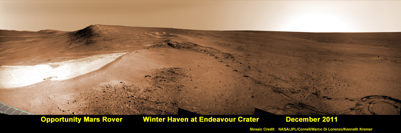
Opportunity Mars Rover at Winter Haven Worksite at Endeavour Crater. NASA’s Opportunity rover has parked near this spot at the “Greeley Haven” worksite where the robot will spend her 5th Martian Winter Haven since landing 8 years ago in January 2004. This mosaic of images was snapped in December 2011 and shows the view from the Cape York Ridge at the western rim of Endeavour Crater looking south along the crater rim to a future area that Opportunity will drive to and explore next spring. Credit: NASA/JPL/Cornell/ Marco Di Lorenzo/Kenneth Kremer
[/caption]
NASA’s seemingly indestructible Opportunity rover has arrived at the breathtaking location where she’ll be working through her unfathomable 5th Martian Winter. The Opportunity Mars Exploration Rover has not only endured, but flourished for 8 years of unending “Exploration & Discovery” on the Red Planet despite having an expected lifetime at landing of just 3 months, way back in January 2004.
Opportunity is parked at a northward facing outcrop dubbed “Greeley Haven” where she can soak up the sun and juice her innards throughout the utterly harsh and Antarctic-like temperatures on tap for the next few months that threaten to kill her each and every Martian day. See our mosaic above around the Greeley Haven area.
Science team members told Universe Today that the rover is sitting at Greeley Haven because the site offers a roughly 15 degree tilt that will maximize the electric output from the life-giving solar arrays and also allow the robot to carry out a vigorous science campaign during the seasonal Martian winter season that officially begins in March.
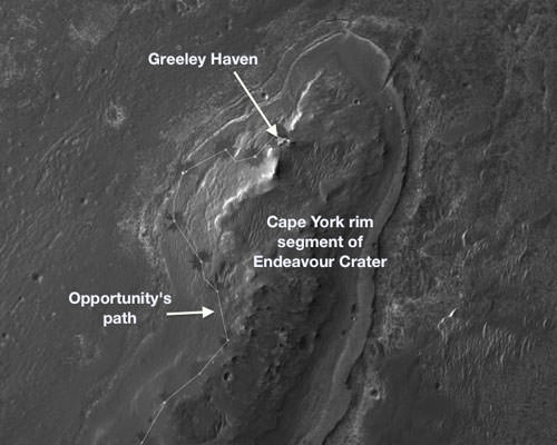
Greeley Haven is a located at the northern tip of the “Cape York” segment of the western rim of the vast crater named Endeavour, some 14 miles (22 km) wide that’s loaded with a bountiful variety of rocks and soil that neither Opportunity nor her twin Spirit have ever touched and drilled into before and stem from an earlier epoch when liquid water flowed eons ago and perhaps may have been more favorable to sustaining life.
“Opportunity is currently sitting on Saddleback at Greeley Haven, an outcrop of impact breccias on Cape York, Endeavour crater’s rim,” Ray Arvidson told Universe Today. Arvisdon is the mission’s deputy principal investigator, of Washington University in St. Louis.
“Her northerly tilt is about ~15 degrees which is enough to have a vibrant winter campaign. The Martian southern winter solstice occurs at the end of March. A few months after that date we will drive her off the outcrop and further explore Cape York.”
Approaching 'Greeley Haven' on Endeavour Rim
Opportunity captured this view of a northward-facing outcrop, "Greeley Haven," where the rover will work during its fifth Martian winter. This southward-looking image was taken on Sol 2790 on Mars (Nov. 29, 2011). The rover team chose this designation as a tribute to the influential planetary geologist Ronald Greeley (1939-2011), who was a member of the science team for the Mars rovers and many other interplanetary missions. Credit: NASA/JPL-Caltech
“Greeley Haven” is named in tribute to planetary Geologist Ronald Greeley (1939-2011) who was a beloved member of the rover science team and a host of other NASA planetary missions. He taught at Arizona State University and inspired several generations of students and planetary scientists until his recent death on Oct. 27, 2011.
“We’ll hunker down at Greeley Haven as long as we need to, and we’ll do good science while we’re there,” Steve Squyres of Cornell University, Ithaca, N.Y., told Universe Today. Squyres is the Principal Investigator for Opportunity.
Opportunity is collecting a high resolution 360 degree panorama to commemorate Greeley.
Throughout the past 4 Martian winters, Opportunity had continued to traverse without pause. But this winter time it’s different because the solar panels are significantly more coated with an obscuring layer of dust hindering their energy output.
So the rover is parked with a tilt for her 5th Martian winter, mimicking the successful strategy power boosting used by Spirit to survive 3 harsh Martian winters.
And there is a silver lining to sitting mostly still that enables a chance to determine what’s at the core of the Red Planet, a key fact we don’t know.
“This winter science campaign will feature two way radio tracking with Earth to determine the Martian spin axis dynamics – thus the interior structure, a long-neglected aspect of Mars,” Arvidson told me.
I asked Squyres for a progress update and how long would the data collection require ?
Squyres replied that the experiment has already begun and added – “Hard to say how long. It’s months, as opposed to weeks or years, but it depends very much on data quality and the amount of data we get per week. We’re very early in the experiment now… we’ll just see how it goes.”
Locator Map for 'Greeley Haven' on Endeavour Crater Rim
Opportunity will spend its fifth Martian winter working at Greeley Haven on the western rim of Endeavour Crater. Credit: NASA/JPL-Caltech/UA
U.S. Congresswoman Rep. Gabrielle Giffords (D) announced today, Sunday Jan. 22, that she will step down from Congress later this week to continue recuperating from critical brain injuries she suffered during a deadly assassination attempt a year ago in Tucson, Arizona.
She announced the resignation on her official congressional website and in a poignant YouTube video message (see above) to her constituents saying that she will “do what is best for Arizona” as she recovers from the shooting attack that happened 1 year ago on Jan. 8, 2011 in her Arizona district.
One of her last official acts will be to attend the State of the Union Address by President Obama on Tuesday, January 24 at the Capitol in Washington, D.C.
Giffords is submitting letters of resignations to House Speaker John Boehner and Arizona Gov. Jan Brewer. Brewer will call a special primary and general election to fill her seat for the remainder of her term which expires at the end of 2012. The primary election will be held within about 60 days. She represented the 8th Congressional District in southern Arizona.
“Gabby Giffords embodies the very best of what public service should be. She’s universally admired for qualities that transcend party or ideology – a dedication to fairness, a willingness to listen to different ideas, and a tireless commitment to the work of perfecting our union. That’s why the people of Arizona chose Gabby – to speak and fight and stand up for them,” President Obama said in a statement issued Sunday evening. “Gabby’s cheerful presence will be missed in Washington. But she will remain an inspiration to all whose lives she touched – myself included. And I’m confident that we haven’t seen the last of this extraordinary American.”
“I salute Congresswoman Giffords for her service, and for the courage and perseverance she has shown in the face of tragedy. She will be missed,” House Speaker John Boehner said in a statement issued Sunday.
Before the shooting she was considered to be a rising star in Congress.
Giffords was shot in the head at point blank range. Six people were killed including a 9 year old girl and a Federal Judge and 13 others were wounded.
The 41 year old congresswoman is resigning in order to continue her recovery from the gunshot wounds she suffered a year ago while conducting a ‘meet-and-greet’ with her constituents at a shopping center in Tucson. She has been undergoing intensive rehabilitation over the past year.
U.S. Congresswoman Rep. Gabrielle Giffords of Arizona announced on Jan. 22, that she will step down from Congress. This still image is from her official video announcement.
“I have more work to do on my recovery, so to do what is best for Arizona, I will step down this week,” Congresswoman Giffords says in the heartfelt two minute video message to her constituents.
“A lot has happened over the past year,” she said in halting words. “We cannot change that. But I know on the issues we fought for, we can change things for the better. Jobs, border security, veterans. We can do so much more by working together.”
The video features footage of Giffords before and after the attack, some of it quite graphic.
“I don’t remember much from that horrible day, but I will never forget the trust you placed in me to be your voice,” Giffords goes on to say. “Thank you for your prayers and for giving me time to recover. I have more work to do on my recovery. So to do what is best for Arizona, I will step down this week.”
Giffords was first elected to the U.S. House of Representatives in November 2006. She was last re-elected in November 2010 and now will not seek re-election this fall.
Gabby Giffords was a strong supporter of NASA and America’s space program.
Gabby Giffords and Mark Kelly
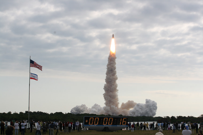
She is married to veteran Astronaut Mark Kelly, who commanded the last mission of Space Shuttle Endeavour in May 2011, STS-134. Kelly recently resigned from NASA to continue helping Gabby in her recovery.
The shooting happened as Kelly was in the final stages of training for the STS-134 mission. Kelly temporarily interrupted his training to be with his wife who was in critical condition.
Space Shuttle Endeavour launches on May 16, 2011 from the Kennedy Space Center with veteran Shuttle Commander Mark Kelly, husband of Congresswoman Gabrielle Giffords. Credit: Ken Kremer
Gabby Giffords has made a remarkable recovery and she continues to improve and inspire all of us every day. She faces a long road of recovery ahead that will require all her efforts to continue making progress.
“Every day my spirit is high. I will return. Thank you !” – Giffords signs off
Three Generations of Mars Rovers in the Mars Yard. This grouping shows 3 generations of NASA’s Mars rovers from 1997 to 2012 set inside the Mars Yard at the Jet Propulsion Lab in Pasadena, Calif. The Mars Pathfinder Project (front) landed the first Mars rover - Sojourner - in 1997. The Mars Exploration Rover Project (left) landed Spirit and Opportunity on Mars in 2004. The Mars Science Laboratory Project (right) is on course to land Curiosity on Mars in August 2012. Credit: NASA/JPL-Caltech
[/caption]
NASA Mars rovers have come a long way in terms of size and capability since the rebirth of Red Planet surface exploration just 15 years ago – spanning from 1997 to 2012.
To get a really excellent sense of just how far America’s scientists and engineers have pushed the state of the art in such a short time – when the willpower and funding existed and coincided to explore another world – take a good look at the new pictures here showing 3 generations of NASA’s Mars rovers; namely Mars Pathfinder (MPF), the 1st generation Mars rover, Mars Exploration Rover (MER), the 2nd generation, and Mars Science Laboratory (MSL), the 3rd and newest generation Mars rover.
The newly released pictures graphically display a side by side comparison of the flight spare for Mars Pathfinder (1997 landing) and full scale test rovers of the Mars Exploration Rover (2004 landing) and Mars Science Laboratory (in transit for a 2012 planned landing). The setting is inside the “Mars Yard” at NASA’s Jet Propulsion Laboratory, Pasadena, Calif. where the teams conduct mission simulations.
It’s been nothing less than a quantum leap in advancement of the scientific and technological capability from one generation to the next.
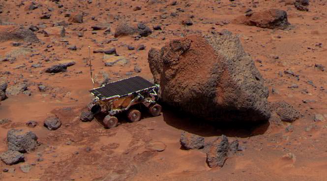
Sojourner - NASA’s 1st Mars Rover
Sojourner takes an Alpha Proton X-ray Spectrometer (APXS) measurement of Yogi rock after Red Planet landing on July 4, 1997 landing. Sojourner was only 2 feet long, the size of a microwave oven.
Credit: NASA
Just consider the big increase in size – growing from a microwave oven to a car !
The “Marie Curie” flight spare and the actual “Sojourner” rover on Mars are 2 feet (65 centimeters) long – about the size of a microwave oven. The MER rovers “Spirit and Opportunity” and the “Surface System Test Bed” rover are 5.2 feet (1.6 meters) long – about the size of a golf cart. The MSL “Curiosity” and the “Vehicle System Test Bed” rover are 10 feet (3 meters) long – about the size of a car.
Side view of Three Generations of Mars Rovers
Front; flight spare for the first Mars rover, Sojourner. Left; Mars Exploration Rover Project test rover. Right; Mars Science Laboratory test rover Credit: NASA/JPL-Caltech
With your own eyes you can see the rapid and huge generational change in Mars rovers if you have the opportunity to visit the Kennedy Space Center Visitor Complex and stroll by the Mars exhibit with full scale models of all three of NASA’s Red Planet rovers.
At the KSC Visitor Complex in Florida you can get within touching distance of the Martian Family of Rovers and the generational differences in size and complexity becomes personally obvious and impressive.
NASA’s Family of Mars rovers at the Kennedy Space Center
Full scale models on display at the Kennedy Space Center Visitor Complex. Curiosity and Spirit/Opportunity are pictured here. Sojourner out of view. Credit: Ken Kremer
All of the Mars rovers blasted off from launch pads on Cape Canaveral Air Force Station, Florida.
Sojourner, Spirit and Opportunity launched atop Delta II rockets at Space Launch Complex 17 in 1996 and 2003. Curiosity launched atop an Atlas V at Space Launch Complex 41 in 2011.
Three Generations of Mars Rovers with Standing Mars Engineers
The rovers are pictured here with real Mars Engineers to get a sense of size and perspective. Front rover is the flight spare for the first Mars rover, Sojourner. At left is a Mars Exploration Rover Project test rover, working sibling to Spirit and Opportunity. At right is a Mars Science Laboratory test rover the size of Curiosity which is targeting a August 2012 Mars landing. The Mars engineers are JPL's Matt Robinson, left, and Wesley Kuykendall. Credit: NASA/JPL-Caltech
Opportunity is still exploring Mars to this day – 8 years after landing on the Red Planet, with a warranty of merely 90 Martian days.
Curiosity is scheduled to touch down inside Gale crater on 6 August 2012.
So, what comes next ? Will there be a 4th Generation Mars rover ?
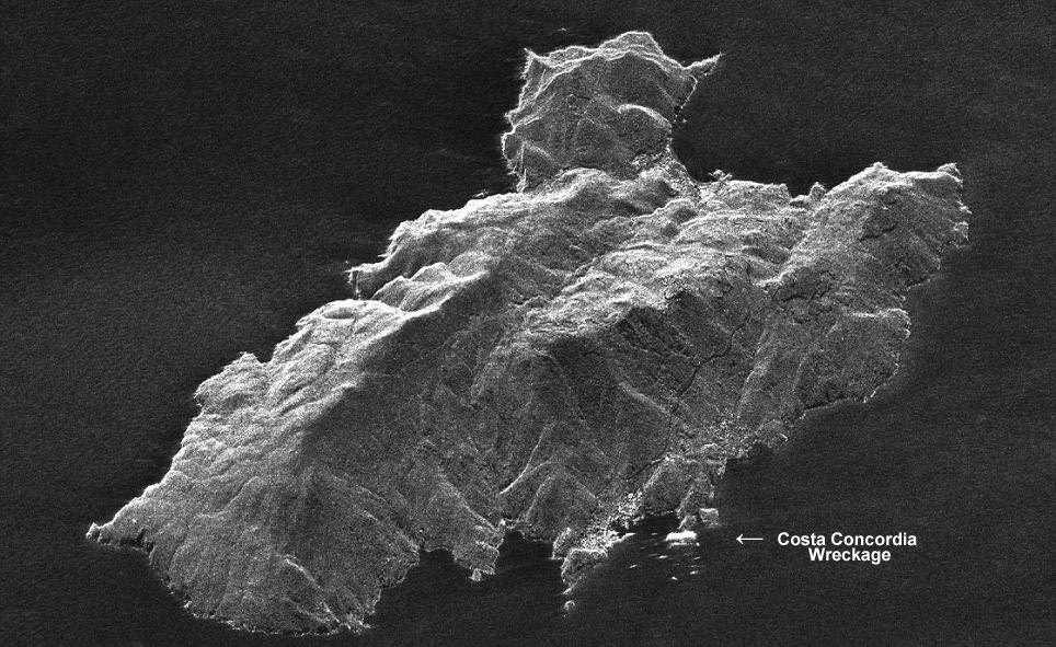
Space Radar Image of Costa Concordia Cruise Ship Catastrophe, Giglio, Italy- January 17, 2012. Image mosaic shows side-by-side comparison of radar and photo imagery from space satellites showing the deadly wreckage of the Costa Concordia luxury cruise ship which ran aground off the shoreline of Giglio,Italy on Friday, January 13, 2012. Image Credit: COSMO-SkyMed (left, bottom right) & DIGITALGLOBE (top, middle right). Mosaic: Marco di Lorenzo/Ken Kremer More Images and Passenger Video below
[/caption]
An amazing new radar image from space (above and below) shows the wreckage of the deadly Costa Concordia catastrophe just hours after the luxury cruise liner struck gigantic rocks jutting up from the shoreline of the Island of Giglio [Isola del Giglio] off the coast of Tuscany, Italy on Friday the 13th of January 2012, sending thousands of terrified tourists screaming for their very lives.
The radar image was snapped by chance during a routine reconnaissance survey by an Italian COSMO-SkyMed satellite orbiting above the Earth, according to the Italian Space Agency (ASI) and clearly shows the Costa Concordia wreckage and entire island of Giglio.
Our composite mosaic above combines the COSMO-SkyMed space radar image with the DigitalGlobe WorldView satellite photo, to provide a side-by-side comparison of the wreckage from the two different satellite systems which have different resolutions. Read my prior story with the stunning DigitalGlobe image – here at Universe Today.
At least 11 people were killed in the still unfolding tragedy and another two dozen people are still missing today, January 19.
Look at this dramatic new YouTube video of passengers scrambling to stay alive
The COSMO-SkyMed satellite normally takes repeat radar images every 16 days. In the case of an oil spill, the satellite would enter automatically an “emergency mode” and start taking very-high resolution images of the affected region, according to ASI.
Severe weather is approaching and could break the ship apart according to news reports. Space Radar Image of Costa Concordia Cruise Ship Wreckage, Giglio, Italy- January 13, 2012
COSMO-SkyMed space radar image taken just hours after Costa Concordia luxury cruise ship ran aground off the shoreline of Giglio, Italy on 13 Jan. 2012. Credit: COSMO-SkyMed
The Costa Concordia is loaded with several thousand gallons of diesel fuel oil and officials are concerned about the very real potential for a leak which could contaminate the beautiful surroundings and harm the local environment
Location Map of Costa Concordia Shipwreck
off the Tuscan coastline of Giglio, Italy
The deadly Jan. 13 collision tore a 70 meter long gash in the ship’s hull, causing the Costa Concordia cruise liner to begin listing. Ultimately the ship fell on its side as it was steered into shallow waters.
Rescue operations resumed today although the ship is still shifting and hazardous to the brave rescue teams.
Helicopters lowered emergency workers onto the top of the wreckage. Divers working below used explosives to blast open new holes in the hull to get to any survivors.
And still more Italian emergency personnel could be seen scaling up the sides – all in a desperate attempt to reach survivors from every possible angle.
But sadly, hopes are fading. A 5 year old Italian girl and her father are among the missing.
Costa Concordia Shipwreck occurred on January 13, 2012
COSMO-SkyMed is a constellation of four Italian satellites that are equipped with Synthetic Aperture Radar (SAR) sensors that provide global coverage of the planet that serves both military and civilian uses such as seismic hazard analysis, environmental disaster monitoring, and agricultural mapping.
The COSMO-SkyMed space radar system provides all weather imagery and is funded by the Italian government and managed by the Italian Space Agency (ASI). Satellite Close-up of Wreckage of Costa Concordia Luxury Cruise Ship of the coast of Giglio, Italy.
Credit: DIGITALGLOBE