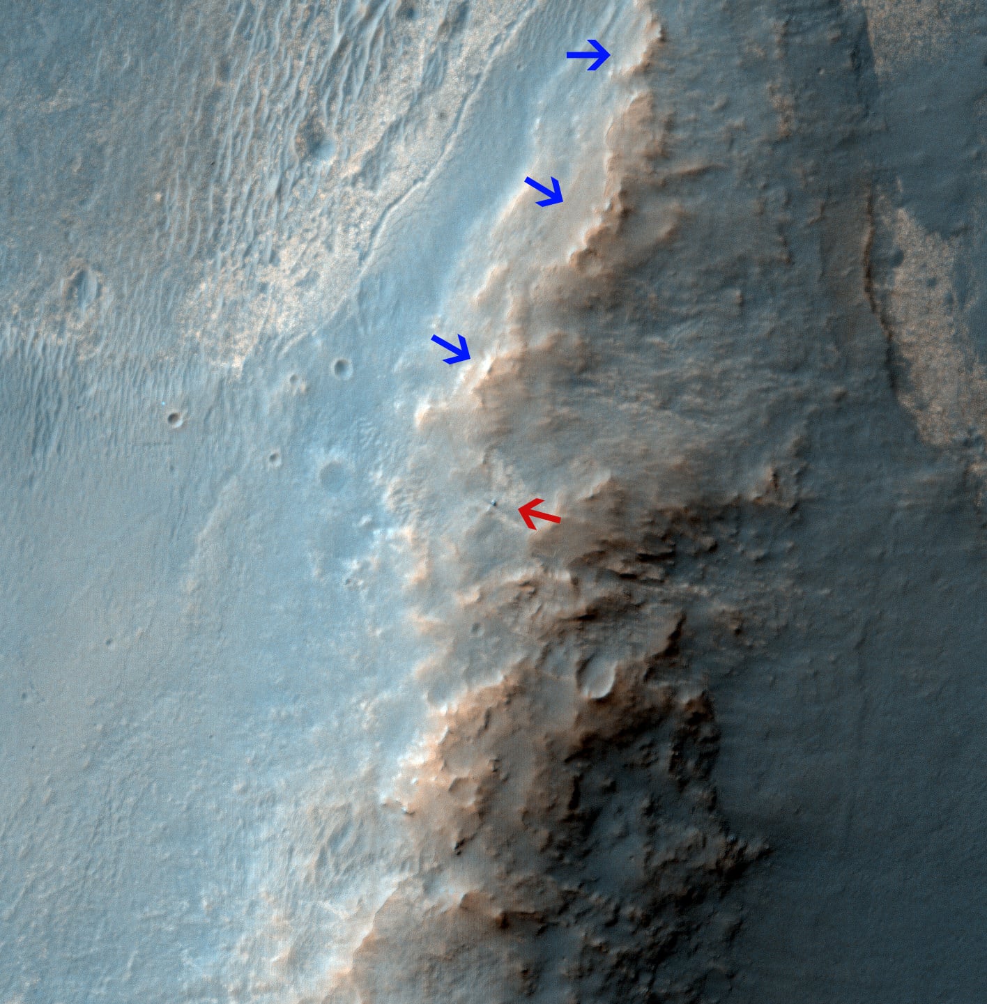
Opportunity Rover on 'Murray Ridge' Seen From Orbit on Valentine's Day 2014
The telescopic High Resolution Imaging Science Experiment (HiRISE) camera on NASA's Mars Reconnaissance Orbiter caught this view of NASA's Mars Exploration Rover Opportunity on Feb. 14, 2014 by the summit of Solander Point. The red arrow points to Opportunity at the center of the image. Blue arrows point to tracks left by the rover since it entered the area seen here, in October 2013. The scene covers a patch of ground about one-quarter mile (about 400 meters) wide. North is toward the top. The location is the "Murray Ridge" section of the western rim of Endeavour Crater. Credit: NASA/JPL-Caltech/Univ. of Arizona
See below corresponding surface view snapped by Opportunity from this location
[/caption]
NASA's renowned
Mars
rover
Opportunity
has been spied anew in a fabulous new photo captured just days ago by NASA's 'Spy in the Sky' orbiter circling overhead
the Red Planet
. See Opportunity from above and below - from today's location. See orbital view above - just released today.
The highly detailed image was freshly taken on Feb. 14 (Valentine's Day 2014) by the telescopic High Resolution Imaging Science Experiment (HiRISE) camera on NASA's Mars Reconnaissance Orbiter (MRO) as the
decade old Opportunity
was investigating the tasty alien terrain on 'Murray Ridge' - nearby the
celebrated 'jelly doughnut' rock
by the summit of Solander Point. See surface views below.
The fabulous
orbital
image shows not only
rover Opportunity
at her location today, but also the breathtaking landscape around
the robots current location as well as some of the wheel tracks created by the
Martian
mountaineer as she climbed from the plains below up to near the
peak of Solander Point
.
The scene is narrowly focused on a spot barely one-quarter mile (400 meters) wide.
Murray Ridge and Solander Point lie at the western rim of a vast crater named Endeavour that spans some 22 kilometers (14 miles) in diameter.
Here is the corresponding Martian surface view snapped by Opportunity on Feb. 16, 2014 (looking back and down to Endeavour crater), while she's being imaged from Mars orbit on Feb. 14, 2014:
[caption id="attachment_109586" align="aligncenter" width="580"]
NASA's Opportunity rover was imaged here from Mars orbit by MRO HiRISE camera on Feb. 14, 2014. This mosaic shows Opportunity's view today while looking back to vast Endeavour crater from atop Murray Ridge by summit of Solander Point. Opportunity captured this photomosaic view on Feb. 16, 2014 (Sol 3579) from the western rim of Endeavour Crater where she is investigating outcrops of potential clay minerals formed in liquid water. Assembled from Sol 3579 colorized navcam raw images. Credit: NASA/JPL/Cornell/Marco Di Lorenzo/Ken Kremer-kenkremer.com[/caption]
Endeavour is an impact scar created billions of years ago. See our 10 Year Opportunity traverse map below.
And believe it or not, that infamous 'jelly doughnut' rock was actually the impetus for this new imaging campaign by NASA's MRO
Martian
'Spysat.'
To help solve the mystery of the origin of the shiny 1.5 inches wide (4 centimeters) 'jelly doughnut' rock, dubbed 'Pinnacle Island', the science team decided to enlist the unparalleled capabilities of the HiRISE camera and imaging team in pursuit of answers.
[caption id="attachment_108285" align="aligncenter" width="580"]
Opportunity by Solander Point peak – 2nd Mars Decade Starts here!
NASA's Opportunity rover captured this panoramic mosaic on Dec. 10, 2013 (Sol 3512) near the summit of "Solander Point" on the western rim of Endeavour Crater where she starts Decade 2 on the Red Planet. She is currently investigating outcrops of potential clay minerals formed in liquid water on her 1st mountain climbing adventure. Assembled from Sol 3512 navcam raw images. Credit: NASA/JPL/Cornell/Marco Di Lorenzo/Ken Kremer-kenkremer.com [/caption]
'Pinnacle Island' had suddenly appeared out of nowhere in a set of before/after pictures taken by Opportunity's cameras on Jan, 8, 2014 (Sol 3540), whereas that exact same spot had been vacant of debris in photos taken barely 4 days earlier. And the rover hadn't budged a single millimeter.
So the HiRISE research team was called in to plan a new high resolution observation of the 'Murray Ridge' area and gather clues about the rocky riddle.
The purpose was to "check the remote possibility that a fresh impact by an object from space might have excavated a crater near Opportunity and thrown this rock to its new location"- now known as Pinnacle Island, said NASA in a statement.
Well, no fresh crater impacting site was found in the new image.
"We see no obvious signs of a very recent crater in our image, but a careful comparison to prior images might reveal subtle changes," wrote HiRISE principal investigator Alfred McEwen in a description today.
[caption id="attachment_108264" align="aligncenter" width="580"]
Back on sol 3365 we took this image of Solander Point as we approached it. Here I have plotted the subsequent route that Opportunity has taken in climbing up the ridge. The outcrop shown I the images below are near the end of the yellow traverse line. Caption and mosaic by Larry Crumpler/NASA/JPL/[/caption]
In the meantime, as I
reported here
a few days ago the mystery was solved at last by the rover team after Opportunity drove a short distance away from the 'jelly doughnut' rock and snapped some 'look back' photographs to document the 'mysterious scene' for further scrutiny.
It turns out that the six wheeled Opportunity unknowingly 'created' the mystery herself when she drove over a larger rock, crushing and breaking it apart with the force from the wheels and her hefty 400 pound (185 kg) mass.
"Once we moved Opportunity a short distance, after inspecting Pinnacle Island, we could see directly uphill an overturned rock that has the same unusual appearance," said Opportunity Deputy Principal Investigator Ray Arvidson of Washington University in St. Louis, in a NASA statement.
"Murray Ridge" and the Solander Point mountaintop are of great scientific interest because the region is riven with outcrops of minerals, including
clay minerals
, that likely formed in flowing liquid neutral water conducive to life - potentially a
scientific goldmine
.
Today, Feb 19, marks Opportunity's 3582nd Sol or Martian Day roving Mars. She is healthy with plenty of power.
So far she has snapped over 188,800 amazing images on the first overland expedition across the Red Planet.
Her total odometry stands at over 24.07 miles (38.73 kilometers) since touchdown on Jan. 24, 2004 at Meridiani Planum.
[caption id="attachment_108291" align="aligncenter" width="580"]
Opportunity by Solander Point peak – 2nd Mars Decade Starts here!
NASA's Opportunity rover captured this panoramic mosaic on Dec. 10, 2013 (Sol 3512) near the summit of "Solander Point" on the western rim of vast Endeavour Crater where she starts Decade 2 on the Red Planet. She is currently investigating summit outcrops of potential clay minerals formed in liquid water on her 1st mountain climbing adventure. See wheel tracks at center and dust devil at right. Assembled from Sol 3512 navcam raw images. Credit: NASA/JPL/Cornell/Marco Di Lorenzo/Ken Kremer-kenkremer.com[/caption]
Read more about sister Spirit -
here
and
here
.
Meanwhile on the opposite side of Mars, Opportunity's younger sister rover
Curiosity
is trekking towards gigantic Mount Sharp and just crested over the
Dingo Gap
sand dune. She celebrated
500 Sols on Mars
on New Years Day 2014.
And a pair of
new orbiters are streaking to the Red Planet
to fortify Earth's invasion fleet- NASA's
MAVEN
and India's
MOM
.
Finally, China's
Yutu rover
has
awoken
for her 3rd workday on the Moon.
Stay tuned here for
Ken's
continuing Opportunity, Curiosity, Chang'e-3, LADEE, MAVEN, Mars rover, MOM and continuing planetary and human spaceflight news.
Ken Kremer
[caption id="attachment_109433" align="aligncenter" width="580"]
This image from the panoramic camera (Pancam) on NASA's rover Opportunity shows the location of a rock called "Pinnacle Island" before it appeared in front of the rover in early January 2014. Arrow at lower left. This image was taken during Sol 3567 of Opportunity's work on Mars (Feb. 4, 2014). Credit: NASA/JPL-Caltech/Cornell Univ./Arizona State Univ.[/caption]
[caption id="attachment_108869" align="aligncenter" width="580"]
Traverse Map for NASA's Opportunity rover from 2004 to 2014
This map shows the entire path the rover has driven during a decade on Mars and over 3560 Sols, or Martian days, since landing inside Eagle Crater on Jan 24, 2004 to current location by Solander Point summit at the western rim of Endeavour Crater. Rover will spend 6th winter here atop Solander. Opportunity discovered clay minerals at Esperance – indicative of a habitable zone. Credit: NASA/JPL/Cornell/ASU/Marco Di Lorenzo/Ken Kremer – kenkremer.com[/caption]
[caption id="attachment_109578" align="aligncenter" width="580"]
NASA's Opportunity rover was imaged here from Mars orbit by MRO HiRISE camera on Feb. 14, 2014. This mosaic shows Opportunity's view today while looking back to vast Endeavour crater from atop Murray Ridge by summit of Solander Point. Opportunity captured this photomosaic view on Feb. 16, 2014 (Sol 3579) from the western rim of Endeavour Crater where she is investigating outcrops of potential clay minerals formed in liquid water. Assembled from Sol 3579 navcam raw images. Credit: NASA/JPL/Cornell/Marco Di Lorenzo/Ken Kremer-kenkremer.com[/caption]