On July 14th, 2015, the
New Horizons
mission made history by conducting the first flyby of Pluto. This represented the culmination of a nine year journey, which began on January 19th, 2006 - when the spacecraft was launched from the Cape Canaveral Air Force Station. And before the mission is complete, NASA hopes to send the spacecraft to investigate objects in the
Kuiper Belt
as well.
To mark the 11th anniversary of the spacecraft's launch, members of the
New Horizons
team took part in panel a discussion hosted by the
Johns Hopkins University Applied Physics Laboratory
(JHUAPL) located in Laurel, Maryland. The event was broadcasted on Facebook Live, and consisted of team members speaking about the highlights of the mission and what lies ahead for the NASA spacecraft.
The live panel discussion took place on Thursday, Sept. 19th at 4 p.m. EST, and included Jim Green and Alan Stern - the director the Planetary Science Division at NASA and the principle investigator (PI) of the
New Horizons
mission, respectively. Also in attendance was Glen Fountain and Helene Winters,
New Horizons
' project managers; and Kelsi Singer, the
New Horizons
co-investigator.
[caption id="attachment_132953" align="aligncenter" width="580"]
Artist's concept of the New Horizons spacecraft encountering a Kuiper Belt object, part of an extended mission after the spacecraft's July 2015 Pluto flyby. Credits: NASA/JHUAPL/SwRI
[/caption]
In the course of the event, the panel members responded to questions and shared stories about the mission's greatest accomplishments. Among them were the many, many high-resolution photographs taken by the spacecraft's Ralph and Long Range Reconnaissance Imager (LORRI) cameras. In addition to providing detailing images of Pluto's surface features, they also allowed for the creation of the very first detailed map of Pluto.
Though Pluto is not officially designated as a planet anymore - ever since the XXVIth General Assembly of the International Astronomical Union, where Pluto was designated as a "dwarf planet" - many members of the team still consider it to be the ninth planet of the Solar System. Because of this, *New Horizons* ' historic flyby was of particular significance.
As Principle Investigator Alan Stern - from the Southwestern Research Institute (SwRI) - explained in an interview with Inverse, the first phase of humanity's investigation of the Solar System is now complete. "What we did was we provided the capstone to the initial exploration of the planets," he said. "All nine have been explored with New Horizons finishing that task."
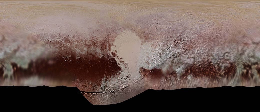
Other significant discoveries made by the *New Horizons* mission include Pluto's famous heart-shaped terrain - aka. Sputnik Planum. This region turned out to be a young, icy plain that contains water ice flows adrift on a "sea" of frozen nitrogen. And then there was the discovery of the large mountain and possible cryovolcano located at the tip of the plain - named Tombaugh Regio, (in honor of Pluto's discovered, Clyde Tombaugh).
[caption id="attachment_131605" align="aligncenter" width="580"]
New Horizons path from the inner Solar System to Pluto and the Kuiper Belt. Credit: NASA/JHUAPL
[/caption]
The mission also revealed further evidence of geological activity and cryovolcanism, the presence of
hyrdocarbon clouds on Pluto
, and conducted the very first measurements of how
Pluto interacts with solar wind
. All told, over 50 gigabits of data were collected by
New Horizons
during its encounter and flyby with Pluto. And the detailed map which resulted from it did a good job of capturing all this complexity and diversity. As Stern
explained
:
“That really blew away our expectations. We did not think that a planet the size of North America could be as complex as Mars or even Earth. It’s just tons of eye candy. This color map is the highest resolution we will see until another spacecraft goes back to Pluto.”
After making its historic flyby of Pluto, the
New Horizons
team requested that the mission receive an extension to 2021 so that it could explore Kuiper Belt Objects (KBOs). This extension was granted, and for the first part of the Kuiper Belt Extended Mission (KEM), the spacecraft will perform a close flyby of the object known as
.
This remote KBO - which is estimated to be between 25 - 45 km (16-28 mi) in diameter - was one of two objects identified as potential targets for research, and the one recommended by the
New Horizons
team. The flyby, which is expected to take place in January of 2019, will involve the spacecraft taking a series of photographs on approach, as well as some pictures of the object's surface once it gets closer.
Before the extension ends in 2021, it will continue to send back information on the gas, dust and plasma conditions in the Kuiper Belt. Clearly, we are not finished with the New Horizons mission, and it is not finished with us!
To check out footage from the live-streamed event, head on over to the
New Horizons Facebook page
.
Further Reading: NASA