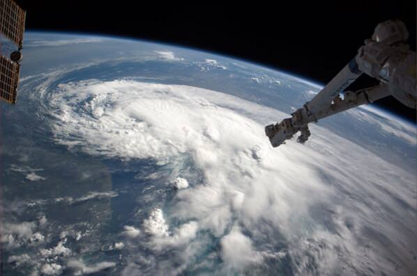
The first storm of the
Atlantic hurricane season
is easily visible from space. International Space Station astronaut
Reid Wiseman
tweeted this picture of the storm, saying, "Just flew over Tropical Storm Arthur – hoping it heads to sea. Looks mean."
Forecasters said the storm is slowly strengthening off Florida's east coast, but will move up the coast just in time for the July 4th holiday in the US. While Tropical Storm Arthur is likely to stay offshore while it cruises by Florida, it might become a hurricane by Thursday. The National Hurricane Center reported at 2 pm EDT Wednesday that a tropical storm warning is in effect for all of coastal North Carolina with a hurricane watch the for the portion of the state that extends into the Atlantic Ocean. As of the time of the report, Tropical Storm Arthur was about 160 km (100 miles) east of Daytona Beach, Florida and 378 km (235 miles) south of Charleston, South Carolina.
[caption id="attachment_112945" align="aligncenter" width="500"]
A graphic showing Tropical Storm Force Wind Speed Probabilities for Tropical Storm Arthur, from July 2 through July 7. Credit: National Hurricane Center/NOAA. [/caption]
For current information about this storm, see the
National Hurricane Center's website.