Towering Cliffs at the Edge of Olympus Mons
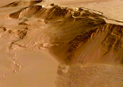
The eastern scarp of the Olympus Mons volcano. Image credit: ESA Click to enlarge
This photograph was taken by ESA’s Mars Express spacecraft. It shows the eastern edge of the Olympus Mons volcano on Mars – the biggest mountain the Solar System. These huge cliffs tower above the relatively flat eastern plains around the mountain. The region has been covered repeatedly by lava flows, as recently as 200 million years ago.
This image, taken by the High Resolution Stereo Camera (HRSC) on board ESA’s Mars Express spacecraft, shows the eastern scarp of the Olympus Mons volcano on Mars.
The HRSC obtained this images during orbit 1089 with a ground resolution of approximately 11 metres per pixel. The image is centred at 17.5 North and 230.5 East. The scarp is up to six kilometres high in places.
The surface of the summit plateau’s eastern flank shows lava flows that have are several kilometres long and a few hundred metres wide.
Age determinations show that they are up to 200 million years old, in some places even older, indicating episodic geological activity.
The lowland plains, seen here in the eastern part of the image (bottom), typically have a smooth surface.
Several channel-like features are visible which form a broad network composed of intersecting and ‘anastomosing’* channels that are several kilometres long and up to 40 metres deep. (*Anastomising means branching extensively and crossing over one another, like veins on the back of your hand.)
Several incisions suggest a tectonic control, others show streamlined islands and terraced walls suggesting outflow activity.
Age determinations show that the network-bearing area was geologically active as recent as 30 million years ago.
Between the edge of the lowland plains and the bottom of the volcano slope, there are ‘wrinkle ridges’ which are interpreted as the result of compressional deformation. In some places, wrinkle ridges border the arch-like terraces at the foot of the volcano slope.
The colour scenes have been derived from the three HRSC-colour channels and the nadir channel. The perspective views have been calculated from the digital terrain model derived from the stereo channels.
The 3D anaglyph image was calculated from the nadir and one stereo channel.
Original Source: ESA Portal
Recent Posts
New Evidence for Our Solar System’s Ghost: Planet Nine
Does another undetected planet languish in our Solar System's distant reaches? Does it follow a…
NASA Takes Six Advanced Tech Concepts to Phase II
It's that time again. NIAC (NASA Innovative Advanced Concepts) has announced six concepts that will…

China is Going Back to the Moon Again With Chang'e-6
On Friday, May 3rd, the sixth mission in the Chinese Lunar Exploration Program (Chang'e-6) launched…
What Can Early Earth Teach Us About the Search for Life?
Earth is the only life-supporting planet we know of, so it's tempting to use it…
China Creates a High-Resolution Atlas of the Moon
Multiple space agencies are looking to send crewed missions to the Moon's southern polar region…
Dinkinesh's Moonlet is Only 2-3 Million Years Old
Last November, NASA's Lucy mission conducted a flyby of the asteroid Dinkinish, one of the…