Tsunami Pictures
Sri Lanka Tsunami pictures
Tsunamis are some of the most devastating natural disasters. The recent Boxing Day Tsunami was generated by an enormous earthquake off the coast of Indonesia on December 26, 2004. Coastlines in Asia were inundated with enormous tsunami surges, killing more than 200,000 people.
Here are some Tsunami pictures capture by satellite that show before and after images of the regions affected by the tsunami.
[/caption]
This photograph shows the devastation that happened in Sri Lanka on December 26th. This picture was taken by the DigitalGlobe Quickbird satellite, and shows how the whole coastline was inundated with water.
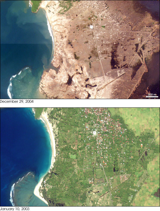
Perhaps the most devastation from the tsunami occurred in Indonesia. This is an image of the town of Lhoknga, Indonesia. It was completely wiped off the map by the tsunami, except for the white mosque in the center of town.
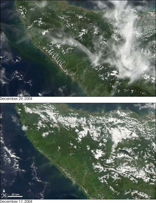
This photograph, captured by NASA’s Terra satellite shows how the whole northwest coast of the island of Sumatra was hit hard by the tsunami. It looks like the vegetation was just scraped back from the edge of the island.
We have written many articles about the devastation from the 2004 tsunami. Here’s an article about how GPS could be used for a tsunami warning system.
You can get many more tsunami pictures from NASA from their Earth observation page.
Recent Posts
NASA Takes Six Advanced Tech Concepts to Phase II
It's that time again. NIAC (NASA Innovative Advanced Concepts) has announced six concepts that will…
China is Going Back to the Moon Again With Chang'e-6
On Friday, May 3rd, the sixth mission in the Chinese Lunar Exploration Program (Chang'e-6) launched…

What Can Early Earth Teach Us About the Search for Life?
Earth is the only life-supporting planet we know of, so it's tempting to use it…
China Creates a High-Resolution Atlas of the Moon
Multiple space agencies are looking to send crewed missions to the Moon's southern polar region…
Dinkinesh's Moonlet is Only 2-3 Million Years Old
Last November, NASA's Lucy mission conducted a flyby of the asteroid Dinkinish, one of the…
The Universe Could Be Filled With Ultralight Black Holes That Can't Die
Steven Hawking famously calculated that black holes should evaporate, converting into particles and energy over…