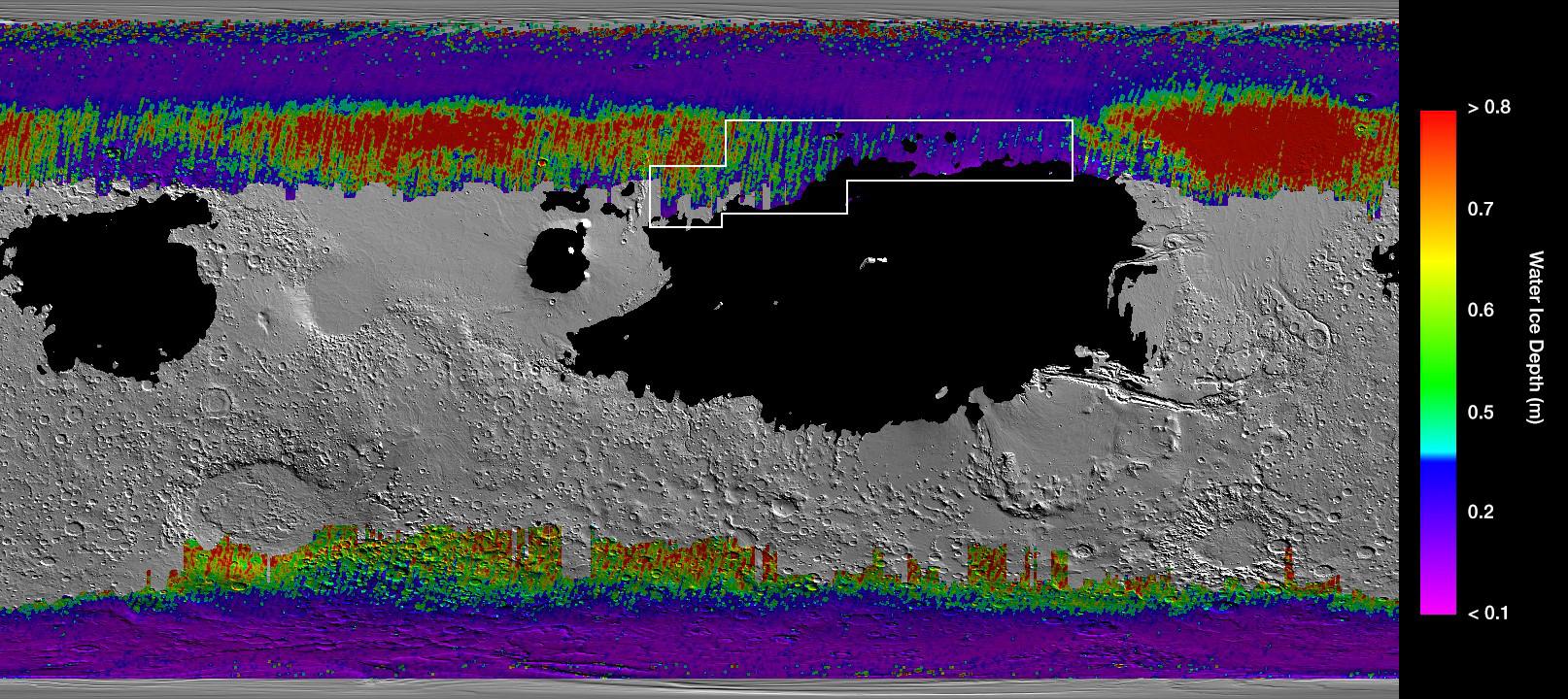
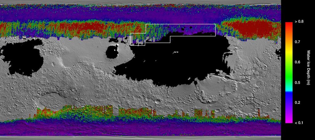
NASA has created a map showing how water is distributed on Mars. The water is frozen under the surface of the planet, and some of it is only 30 cm (12 inches) deep. At that depth, astronauts won't need a machine to access it: just a shovel.
Ancient Mars used to be warm and had water flowing over its surface. There were rivers, crater lakes, and even oceans. But now most of that water is gone, and what's left is frozen. Some of it's at the poles, but much of it is under the surface, and has been there for a long time.
With plans to go to Mars in the works, it matters where resources are on that planet. And water is a chief resource. Its location will be a determinant in future missions to the red planet. It'll be challenging to carry enough water to Mars, so finding it in situ will be key. The buried water ice can be used for drinking, maybe even agriculture, and definitely to make rocket fuel. When humans build their first outpost or research station on Mars, it'll need to be near water.
The Mars water map is presented in a new paper published in Geophysical Research Letters. The paper is titled " Widespread Shallow Water Ice on Mars at High and Mid Latitudes." The lead author is Sylvain Piqueux of NASA's Jet Propulsion Laboratory.
Missions to Mars need to us resources that are available there. That's called in-situ resource utilization (ISRU,) something NASA is keenly interested in. But to make use of Martian resources, we need to know what's available, where it is, how much of it there is, and how it can be accessed. Luckily, orbiting satellites are providing much of that information. This new global Mars water map made use of data from NASA's Mars Reconnaissance Orbiter (MRO) and Mars Odyssey orbiter.
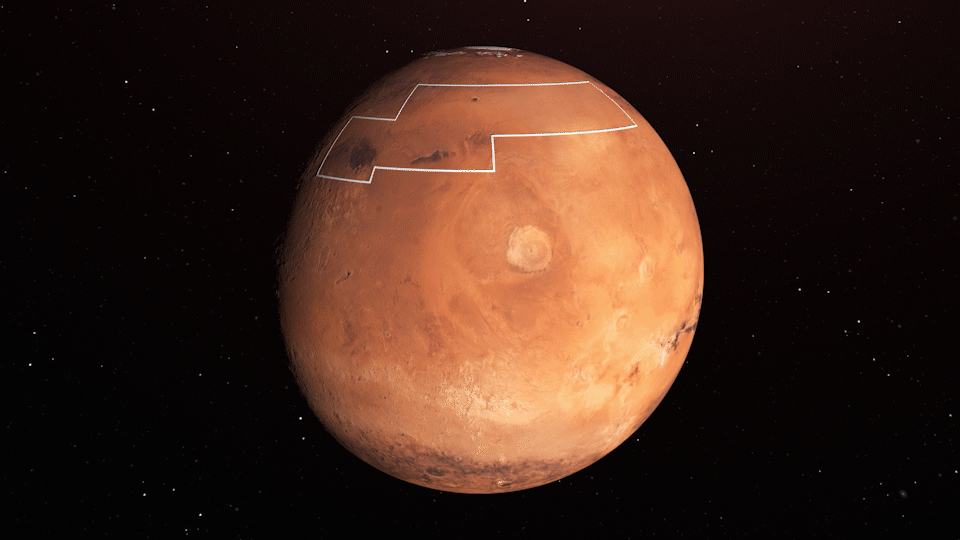
https://gfycat.com/marvelousvaguearcherfish The annotated area of Mars in this illustration holds near-surface water ice that would be easily accessible for astronauts to dig up. The water ice was identified as part of a map using data from NASA orbiters. Image Credit: NASA/JPL-Caltech
"You wouldn't need a backhoe to dig up this ice. You could use a shovel," said lead author, Sylvain Piqueux of NASA's Jet Propulsion Laboratory in Pasadena, California. "We're continuing to collect data on buried ice on Mars, zeroing in on the best places for astronauts to land," Piqueux said in a press release.
Currently, it looks like a large swath in Mars' northern hemisphere has plentiful water only about 30 cm (12 inches) beneath the surface.
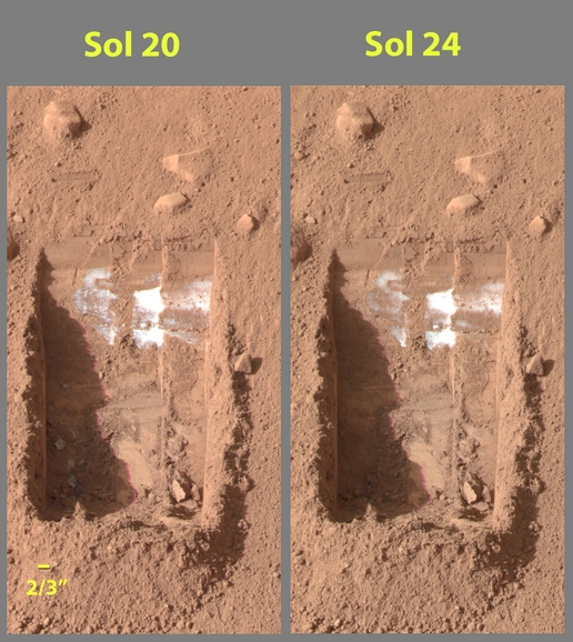
NASA isn't relying only on satellite data to confirm the presence of underground ice. Back in 2008 the Phoenix lander captured images of sub-surface ice. Two images show how some of it sublimated over the course of four days.
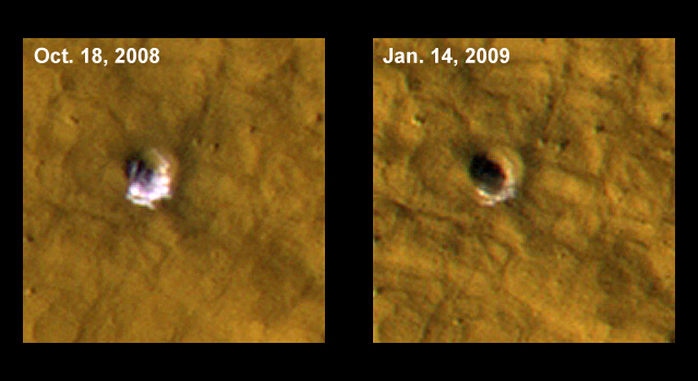
Meteor impacts have also confirmed the presence of the sub-surface ice. In 2009, NASA released MRO images of a 6 meter (20 ft) wide impact site. The first image shows the ice and the second image from three months later shows how most of it has sublimated into the thin Martian atmosphere.
In this new study, the authors relied on three instruments: the Climate Sounder on the MRO and the Thermal Emission Imaging System (THEMIS) camera and the Gamma Ray Spectrometer (GRS) on Mars Odyssey. The Climate Sounder and THEMIS are both heat-sensitive instruments and served a primary role in the study. The GRS can detect water and identify elements in the Martian regolith.
The heat sensing works because ice is a much more effective heat conductor than the surrounding Martian regolith. That means that the buried ice has a measurable effect on seasonal temperature measurements. And the ice's depth controls the amplitude of the effect.
Alongside the heat-sensing data, the authors used data from the GRS on the Mars Reconnaissance Orbiter. They also cross-checked with radar data showing underground ice deposits, and with images of impact craters that show exposed ice. The ice deposits are also "correlated with periglacial features" as the authors say in their paper.
Any crewed mission to Mars must take two overarching requirements into account: scientific interest and practicality.
There are a multitude of locations on Mars that are scientifically interesting and deserve to be visited. But a mission with a human crew means practical considerations are important. As the press release makes clear, "Most scientists have homed in on the northern and southern mid-latitudes, which have more plentiful sunlight and warmer temperatures than the poles. But there's a heavy preference for landing in the northern hemisphere, which is generally lower in elevation and provides more atmosphere to slow a landing spacecraft." And now we know that a large part of the northern hemisphere contains abundant water ice, which strengthens the argument for landing a crewed mission there.
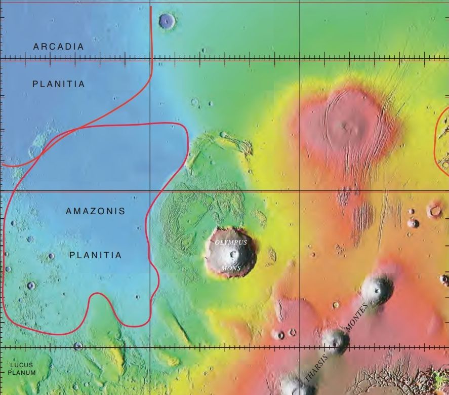
This study shows that when it comes to the northern hemisphere of Mars, the Arcadia Planitia region is a desirable target. There is plenty of water ice there, widespread and accessible under only 30 cm or so of regolith. That area also lacks the softer regions that are hazardous to spacecraft. The data shows that any spacecraft attempting to land in the widespread softer regions would likely get stuck in the fine dust.
This study is just a step towards understanding the buried water ice. Piqueux is planning a more comprehensive study over multiple seasons to see how the ice behaves. Its accessibility and abundance may change over time.
"The more we look for near-surface ice, the more we find," said MRO Deputy Project Scientist Leslie Tamppari of JPL. "Observing Mars with multiple spacecraft over the course of years continues to provide us with new ways of discovering this ice."
More:
- Press Release: NASA's Treasure Map for Water Ice on Mars
- Research Paper: Widespread Shallow Water Ice on Mars at High and Mid Latitudes
- Universe Today: New layers of water ice have been found beneath Mars’ North Pole