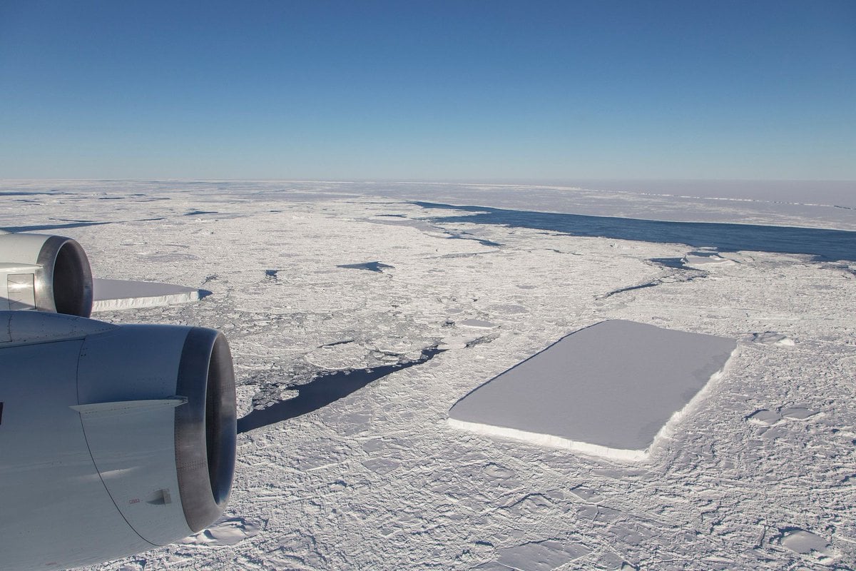
Some see the hand of God, some see the law of large numbers, and some just see cool looking icebergs. Whichever way you lean, these rectangular icebergs grab your attention.
NASA scientist Jeremy Harbeck spotted the rectangular icebergs while working on
Operation IceBridge
. IceBridge is an ongoing NASA mission that uses a fleet of aircraft to study the annual changes in thickness of sea ice, glaciers and ice sheets. It's the largest airborne survey of Earth's polar ice ever flown.
"I often see icebergs with relatively straight edges, but I've not really seen one before with two corners at such right angles like this one had." - Jeremy Harbeck, NASA Scientist, Operation IceBridge
According to Harbeck, straight-edged icebergs are not that unusual, but these right-angle, rectangular 'bergs are unheard of. "I thought it was pretty interesting; I often see icebergs with relatively straight edges, but I've not really seen one before with two corners at such right angles like this one had," Harbeck said.
The rectangular icebergs have garnered a lot of attention on social media.
The famous @NASA_ICE square iceberg has been moving quite a lot, and indeed cracked up a bit in recent days (becoming more square, oddly enough). Nice sleuthing w/ @albgarci. https://t.co/dxVANLMnU8 — Peter Neff (@peter_neff)
The rectangular icebergs appear to be freshly calved from the massive
A68 iceberg
. A68 itself came from the Larsen C feature, which is the largest part of the
Larsen Ice Shelf
. The Larsen Ice Shelf is an ice feature located on the eastern coast of the Antarctic Peninsula. A68 is noteworthy, because it's a chunk of ice about the size of the state of Delaware that split off from the Larsen Ice Shelf in July 2017.
[caption id="attachment_140334" align="alignnone" width="419"]
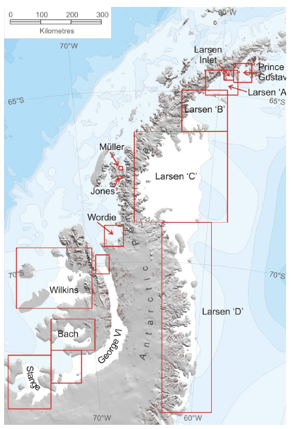
The rectangular icebergs came from a part of the Antarctic sea ice called Larsen C. Image Credit: By A. J. Cook and D. G. Vaughan, CC BY 3.0[/caption]
"I was actually more interested in capturing the A68 iceberg that we were about to fly over, but I thought this rectangular iceberg was visually interesting and fairly photogenic, so on a lark, I just took a couple photos," Harbeck said.
[caption id="attachment_140335" align="alignnone" width="320"]
NASA scientist Jeremy Harbeck captured this image of rectangular icebergs as part of Operation IceBridge. Image: NASA/Jeremy Harbeck.[/caption]
Operation IceBridge captures detailed yearly images of both polar icecaps. It images the Greenland area in the Spring and the Antarctica in the Fall. Harbeck captured these images this Fall on a flight from Punta Arenas, Chile.
The IceBridge program is a part of an overall effort to document the change in ice sheets in the polar regions. NASA's launched its Ice, Cloud and Land Elevation Satellite (ICESat) in 2003 to fulfill the same mission, but it de-orbited in 2010. Its successor,
ICESat 2
, will pick up where ICESat 1 left off. NASA launched ICESat 2 on September 15, 2018 and the IceBridge program bridges the gap between the 2 satellites. Without IceBridge, there would have been a 5 year gap in the data.
The
ICESat
program monitors more than just ice coverage. ICESat was the benchmark Earth Observing System mission for measuring ice sheet mass balance, cloud and aerosol heights, as well as land topography and vegetation characteristics. From 2003 to 2009, the ICESat mission provided multi-year elevation data needed to determine ice sheet mass balance as well as cloud property information, especially for stratospheric clouds common over polar areas. It also provided topography and vegetation data around the globe, in addition to the polar-specific coverage over the Greenland and Antarctic ice sheets. ICESat2 will continue the mission.
Sources:
- NASA Press Release: " 2 Rectangular Icebergs Spotted on NASA IceBridge Flight "
- NASA: IceBridge Mission Overview
- Wikipedia entry: Larsen Ice Shelf
- NASA: ICESat2
- NASA: ICESat