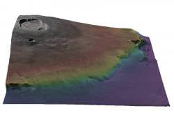
I know this is going to sound like an advertisement for a B-movie, but you can see Mars in 3-dimensions, thanks to a new set of data released by the European Space Agency. The images were captured by its Mars Express spacecraft using special techniques so they could later be stitched together into 3-dimensional images. Next up, Smell-O-Vision?
ESA announced the release to the Internet of their new Digital Terrain Model data set today. When you’re looking at bird’s eye images of terrain, it’s hard to get a sense of elevation, or features of the surrounding topography. These models recreate a 3-dimensional view of the terrain so that scientists can virtually “stand” on a planetary surface and look around.
The image associated with this story is of Olympus Mons, the tallest mountain in the Solar System. The different colours are associated with different elevations.
To build these kinds of images in the past, you needed a spacecraft to make multiple passes over terrain. This is just like how you can construct a 3-dimensional model in your brain. Because you use two eyes, the multiple images can be stitched together to give a stereo view.
But Mars Express is different. Its High Resolution Stereo Camera can build up 3-D images in just a single pass. It has 9 individual scan lines that point ahead, behind, and straight down. It can then gather everything it needs by passing over terrain. Scientists back on Earth can stitch the images together on computer to create the 3-dimensional view.
It’s also equipped with a laser altimeter instrument that allows it to measure the height to every point it sees. This helps build up a topographical map of the terrain.
One of the best ways to look at the images coming back from Mars is with the HRSC Image viewing tool. Check it out.
Original Source: ESA News Release


Could HIRISE generate similar images?
Wow, that makes good sense to take advantage of the craft’s motion to generate a 3D image. Sounds simple if you know the position & time along the trajectory.
Tell them to talk to Google. Their engne does 3-D maps so much better!