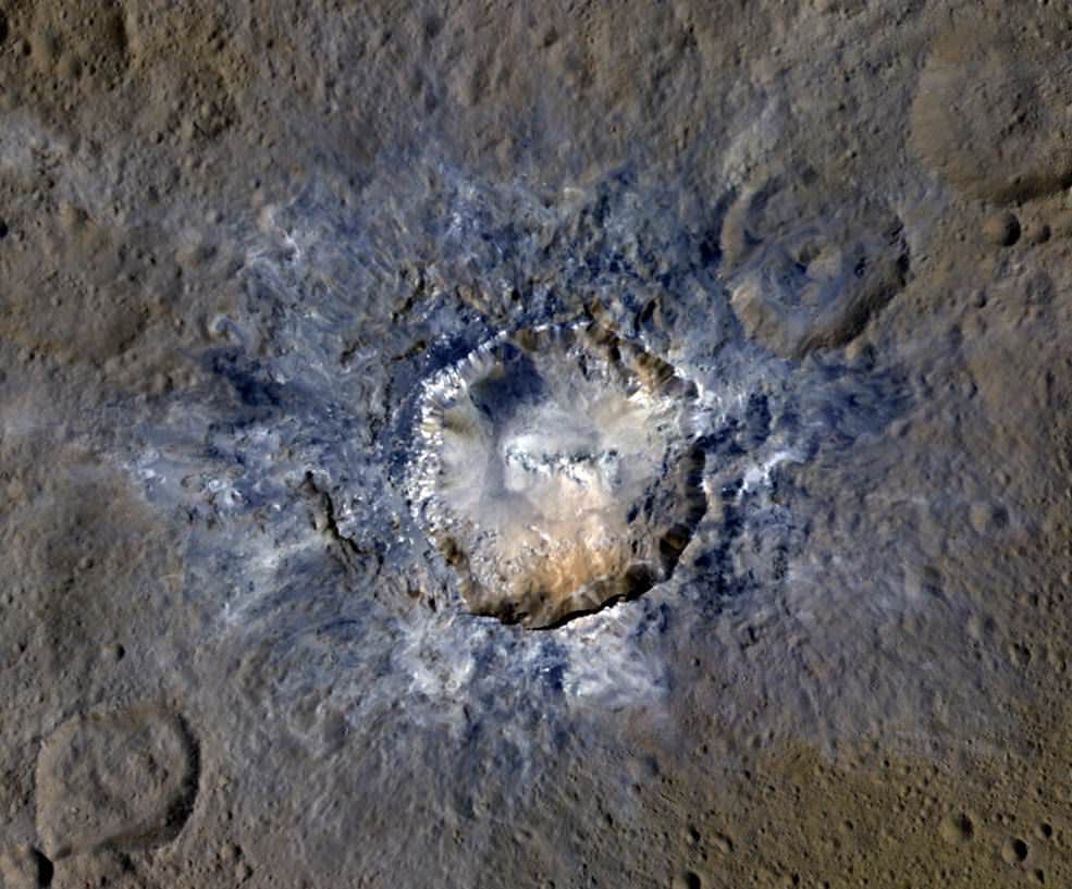
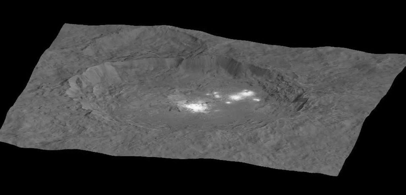
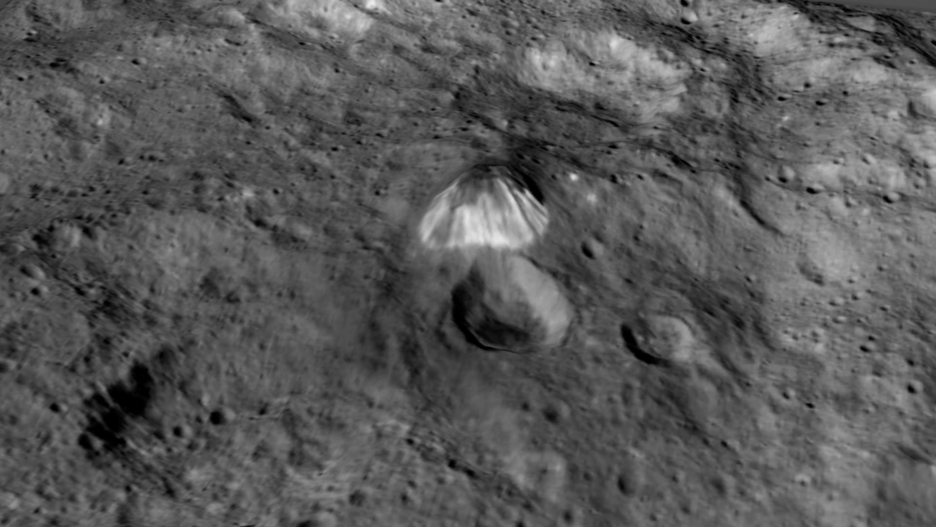
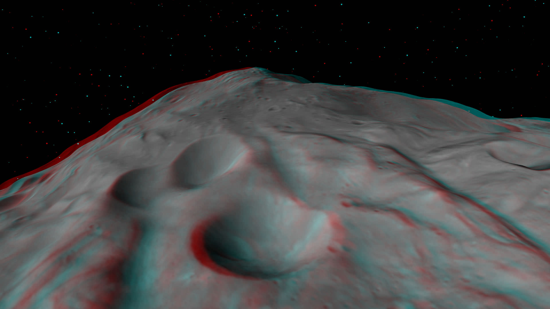
Ceres' Haulani Crater, with a diameter of 21 miles (34 kilometers), shows evidence of landslides from its crater rim. Credits: NASA/JPL-Caltech/UCLA/MPS/DLR/IDA
Ceres’ Haulani Crater, with a diameter of 21 miles (34 kilometers), shows evidence of landslides from its crater rim. Credits: NASA/JPL-Caltech/UCLA/MPS/DLR/IDA
Now in orbit for just over a year at dwarf planet Ceres, NASA’s Dawn spacecraft continues to astound us with new discoveries gleaned from spectral and imagery data captured at ever decreasing orbits as well as since the probe arrived last December at the lowest altitude it will ever reach during the mission.
Mission scientists have just released marvelous new images of Haulani and Oxo craters revealing landslides and mysterious slumps at several of the mysterious bright craters on Ceres – the largest asteroid in the main Asteroid Belt between Mars and Jupiter.
The newly released image of oddly shaped Haulani crater above, shows the crater in enhanced color and reveals evidence of landslides emanating from its crater rim.
“Rays of bluish ejected material are prominent in this image. The color blue in such views has been associated with young features on Ceres,” according to the Dawn science team.
“Enhanced color allows scientists to gain insight into materials and how they relate to surface morphology.”
Look at the image closely and you’ll see its actually polygonal in nature – meaning it resembles a shape made of straight lines – unlike most craters in our solar system which are nearly circular.
”The straight edges of some Cerean craters, including Haulani, result from pre-existing stress patterns and faults beneath the surface,” says the science team.
Haulani Crater has a diameter of 21 miles (34 kilometers) and apparently was formed by an impacting object relatively recently in geologic time and is also one of the brightest areas on Ceres.
“Haulani perfectly displays the properties we would expect from a fresh impact into the surface of Ceres. The crater floor is largely free of impacts, and it contrasts sharply in color from older parts of the surface,” said Martin Hoffmann, co-investigator on the Dawn framing camera team, based at the Max Planck Institute for Solar System Research, Göttingen, Germany, in a statement.
The enhanced color image was created from data gathered at Dawn’s High Altitude Mapping Orbit (HAMO), while orbiting at an altitude of 915 miles (1,470 kilometers) from Ceres.
Data from Dawn’s VIR instrument shows that Haulani’s surface is comprised of different materials than its surroundings.
“False-color images of Haulani show that material excavated by an impact is different than the general surface composition of Ceres. The diversity of materials implies either that there is a mixed layer underneath, or that the impact itself changed the properties of the materials,” said Maria Cristina de Sanctis, the VIR instrument lead scientist, based at the National Institute of Astrophysics, Rome.
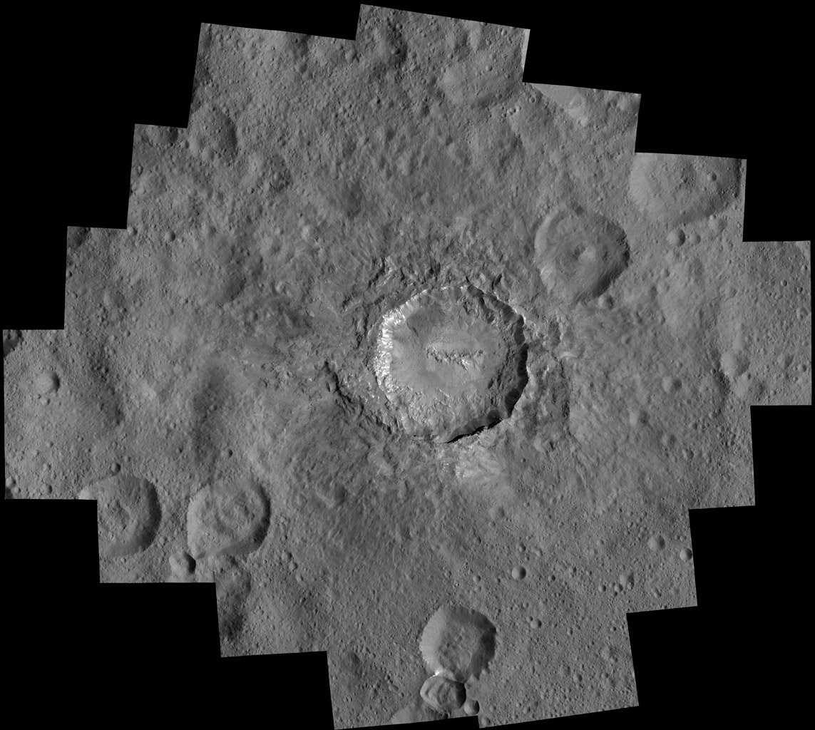
Since mid-December, Dawn has been orbiting Ceres in its Low Altitude Mapping Orbit (LAMO), at a distance of 240 miles (385 kilometers) from Ceres, resulting in the most stunning images ever of the dwarf planet.
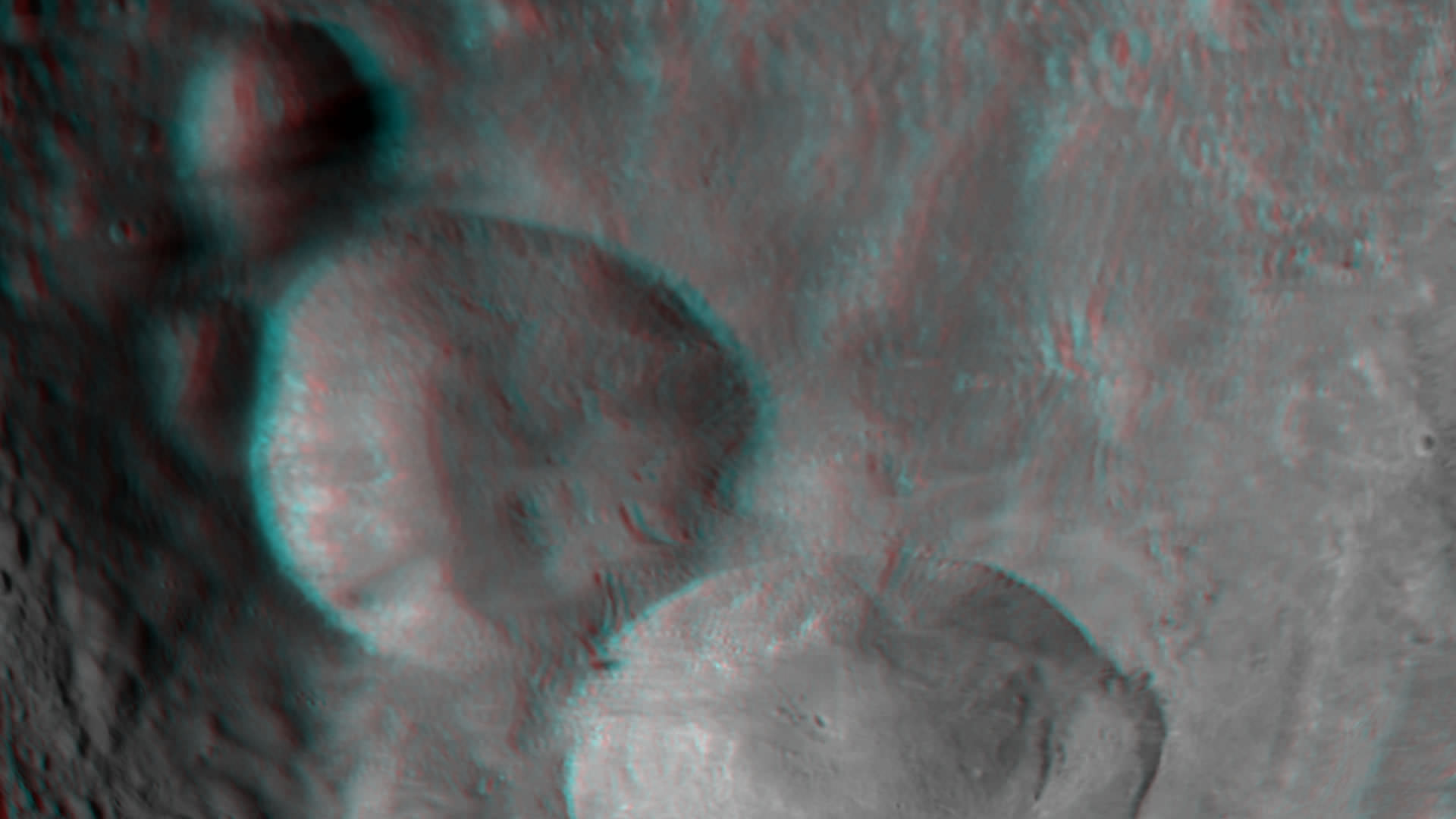
By way of comparison the much higher resolution image of Haulani crater below, is a mosaic of views assembled from multiple images taken from LAMO at less than a third of the HAMO image distance – at only 240 miles (385 kilometers) above Ceres.
Haulani Crater at LAMO. NASA’s Dawn spacecraft took this mosaic view of Haulani Crater at a distance of 240 miles (385 kilometers) from the surface of Ceres. Credits: NASA/JPL-Caltech/UCLA/MPS/DLR/IDA/PSI
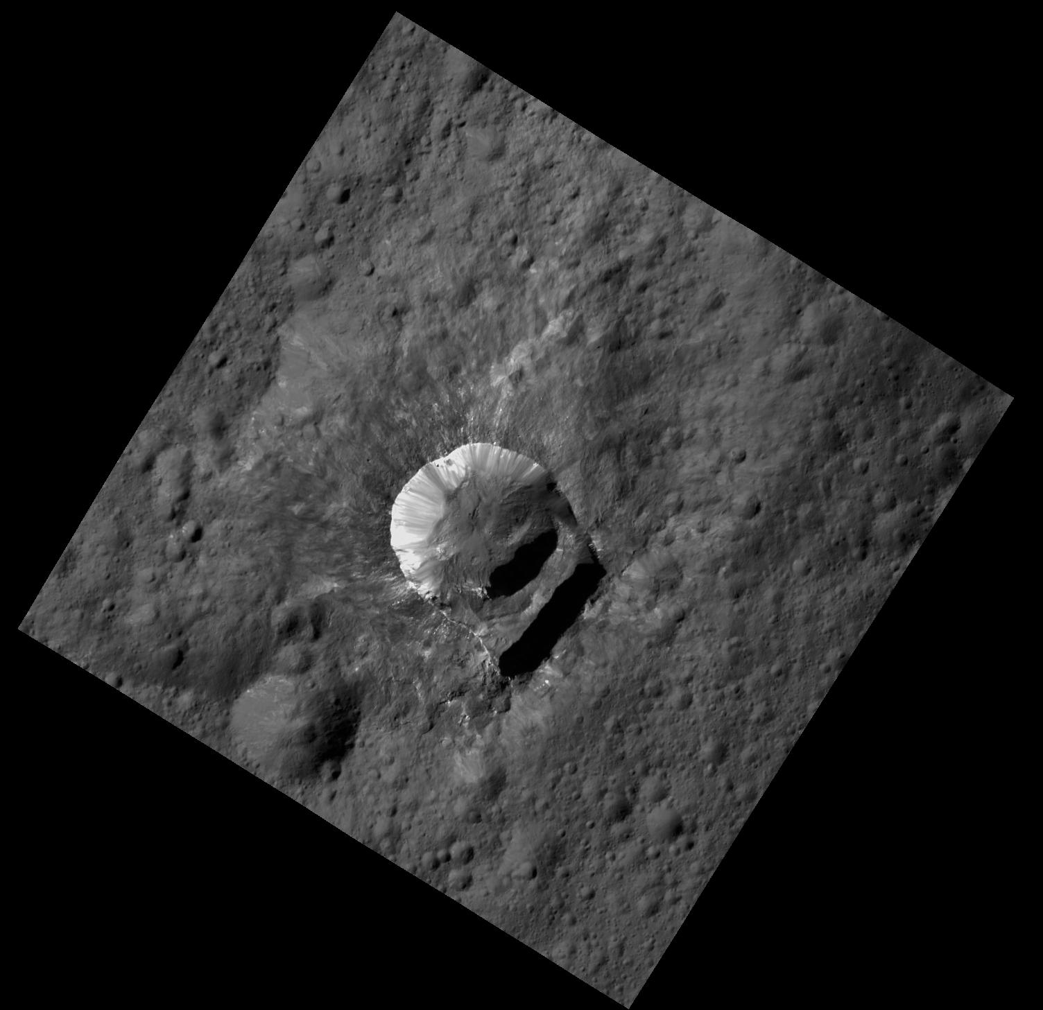
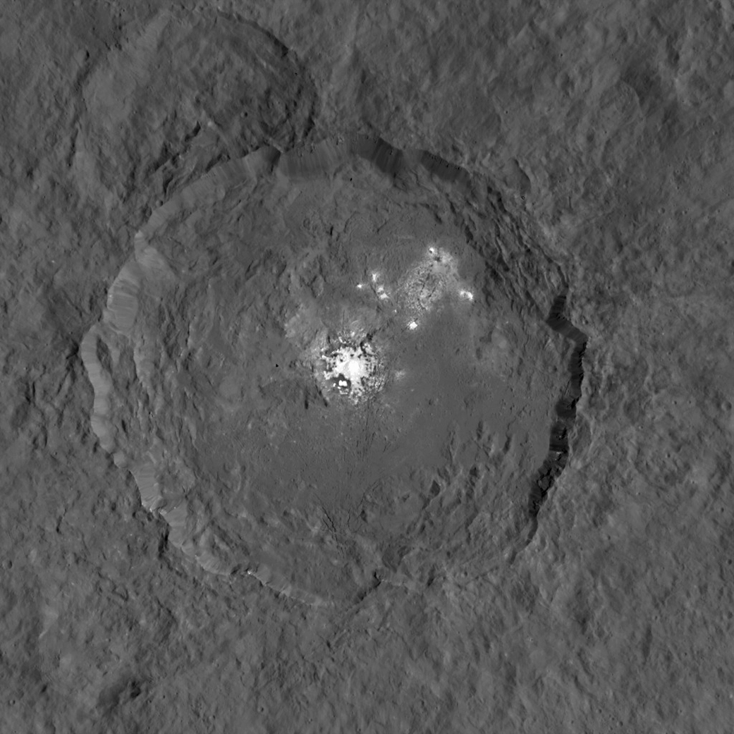
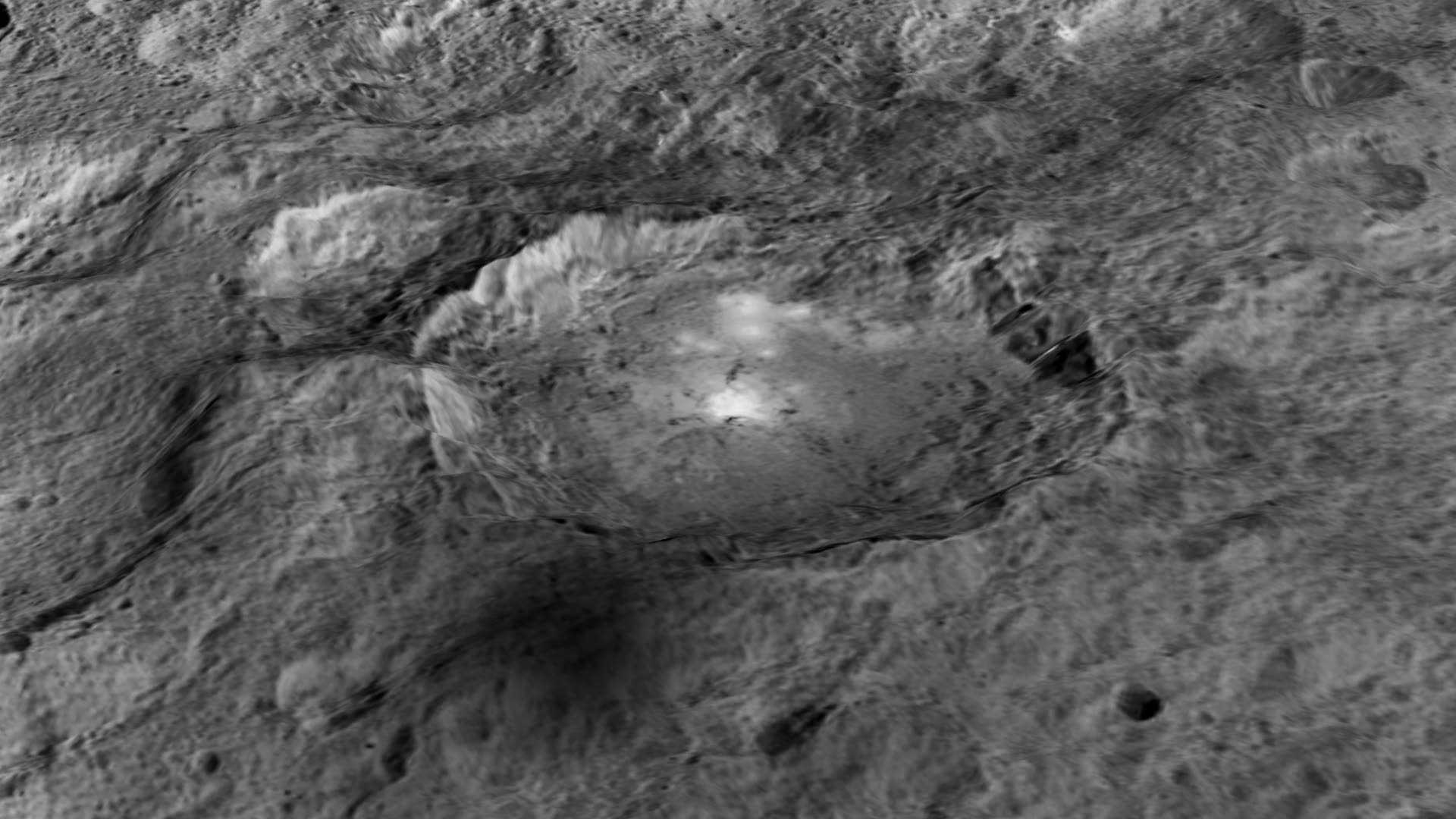
Dawn has also been busy imaging Oxo Crater, which despite its small size of merely 6-mile-wide (10-kilometer-wide) actually counts as a “hidden treasure” on Ceres – because it’s the second-brightest feature on Ceres!
Only the mysterious bright region comprising a multitude of spots inside Occator Crater shine more brightly on Ceres.
Most importantly, Oxo Crater is the only place on Ceres where Dawn has detected water at the surface so far. Via VIR, Dawn data indicate that the water exists either in the form of ice or hydrated minerals. Scientists speculate that the water was exposed either during a landslide or an impact.
“Little Oxo may be poised to make a big contribution to understanding the upper crust of Ceres,” said Chris Russell, principal investigator of the mission, based at the University of California, Los Angeles.
The signatures of minerals detected on the floor of Oxo crater appears to be different from the rest of Ceres.
Furthermore Oxo is “also unique because of the relatively large “slump” in its crater rim, where a mass of material has dropped below the surface.”
Oxo Crater on Ceres is unique because of the relatively large “slump” in its crater rim. The 6-mile-wide (10-kilometer-wide) Oxo crater is the second-brightest feature on Ceres. Credits: NASA/JPL-Caltech/UCLA/MPS/DLR/IDA/PSI
Dawn is Earth’s first probe in human history to explore any dwarf planet, the first to explore Ceres up close and the first to orbit two celestial bodies.
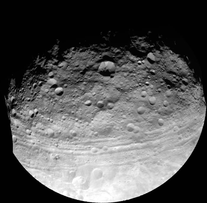
The asteroid Vesta was Dawn’s first orbital target where it conducted extensive observations of the bizarre world for over a year in 2011 and 2012.
The mission is expected to last until at least later into 2016, and possibly longer, depending upon fuel reserves.
Dawn will remain at its current altitude at LAMO for the rest of its mission, and indefinitely afterward, even when no further communications are possible.
Stay tuned here for Ken’s continuing Earth and planetary science and human spaceflight news.
This representation of Ceres' Occator Crater in false colors shows differences in the surface composition. Red corresponds to a wavelength range around 0.97 micrometers (near infrared), green to a wavelength range around 0.75 micrometers (red, visible light) and blue to a wavelength range of around 0.44 micrometers (blue, visible light). Occator measures about 60 miles (90 kilometers) wide. Credits: NASA/JPL-Caltech/UCLA/MPS/DLR/IDA
This representation of Ceres’ Occator Crater in false colors shows differences in the surface composition. Red corresponds to a wavelength range around 0.97 micrometers (near infrared), green to a wavelength range around 0.75 micrometers (red, visible light) and blue to a wavelength range of around 0.44 micrometers (blue, visible light). Occator measures about 60 miles (90 kilometers) wide. Credits: NASA/JPL-Caltech/UCLA/MPS/DLR/IDA
With NASA’s Dawn spacecraft set to enter its final and lowest orbit around the dwarf planet Ceres, spectral measurements are enabling researchers to gradually unravel the nature of the numerous mysterious and intriguing bright spots recently discovered, and now they conclude that briny mixtures of ice and salts apparently reside just beneath certain patches of the pockmarked surface and that “water is sublimating” from the surface of an “active crater”.
This mosaic shows Ceres' Occator crater and surrounding terrain from an altitude of 915 miles (1,470 kilometers), as seen by NASA's Dawn spacecraft. Occator is about 60 miles (90 kilometers) across and 2 miles (4 kilometers) deep. Credits: NASA/JPL-Caltech/UCLA/MPS/DLR/IDA
The most dazzling views ever seen of dwarf planet Ceres and its mysterious bright spots are what’s on tap by year’s end as NASA’s amazing Dawn spacecraft starts a gradual but steep descent over the next two months to its lowest and final orbit around the bizarre icy body.
Engineers at NASA’s Jet Propulsion Laboratory (JPL) successfully fired up the probes exotic ion propulsion system to begin lowering Dawn’s orbital altitude to less than a quarter of what it has been for the past two months of intense mapping operations.
On Oct. 23, Dawn began a seven-week-long dive that uses ion thruster #2 to reduce the spacecrafts vantage point from 915 miles (1,470 kilometers) at the High Altitude Mapping Orbit (HAMO) down to less than 235 miles (380 kilometers) above Ceres at the Low Altitude Mapping Orbit (LAMO).
Dawn is slated to arrive at LAMO by mid-December, just in time to begin delivering the long awaiting Christmas treats.
Ceres has absolutely tantalized researchers far beyond their wildest expectations.
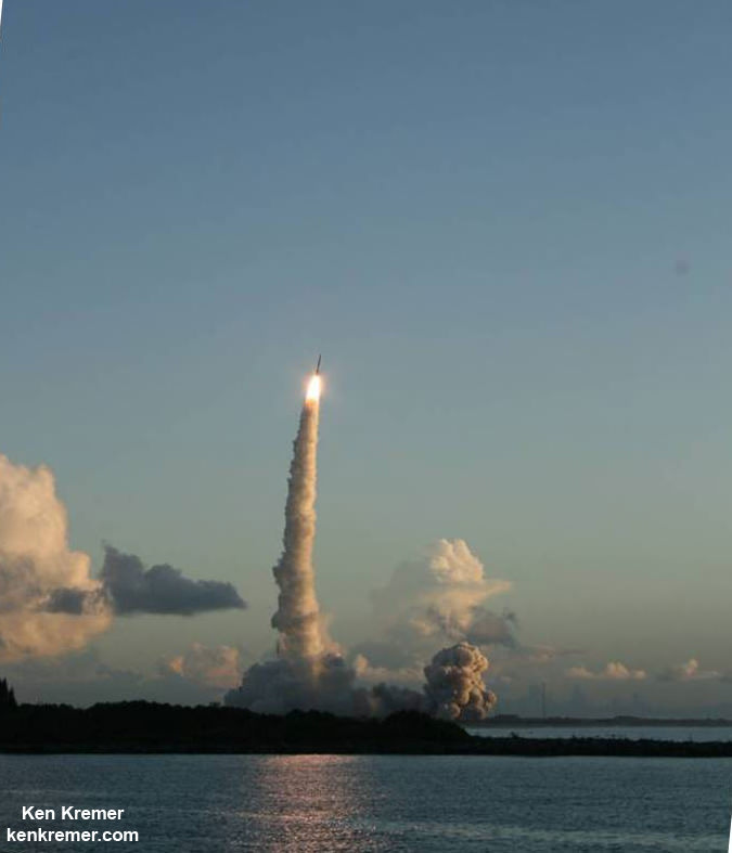
When Dawn arrives at LAMO it will be the culmination of an eight year interplanetary voyage that began with a blastoff on September 27, 2007 by a United Launch Alliance (ULA) Delta II Heavy rocket from Space Launch Complex-17B (SLC-17B) at Cape Canaveral Air Force Station, Florida.
LAMO marks Dawn’s fourth, lowest and final science orbit at Ceres where the highest resolution observations will be gathered and images from the framing camera will achieve a resolution of 120 feet (35 meters) per pixel.
Dawn’s low altitude mapping orbit LAMO. This shows how the orbit naturally shifts slightly (relative to the sun) during the three months of LAMO, starting in blue and ending in red. The spacecraft completes each revolution in 5.5 hours, and Ceres rotates in 9.1 hours, so Dawn will be able to view the entire surface. Credit: NASA/JPL
At LAMO, researchers hope to finally resolve the enduring mystery of the nature of the bright spots that have intrigued science and the general public since they were first glimpsed clearly early this year as Dawn was on its final approach to Ceres.
Dawn arrived in orbit this past spring on March 6, 2015.
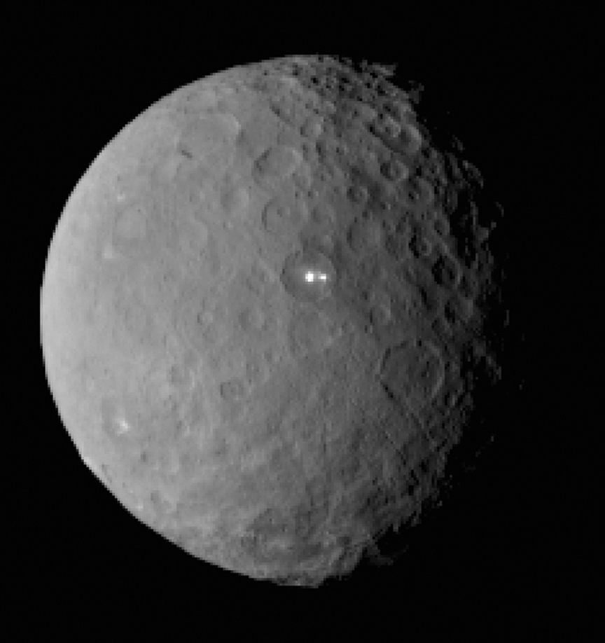
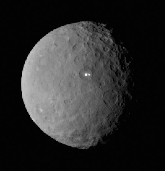
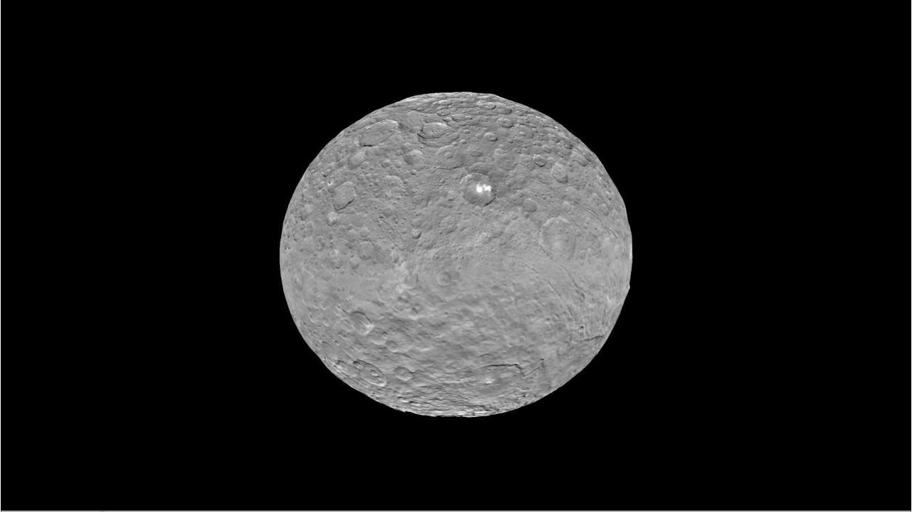
This image was taken by NASA’s Dawn spacecraft of dwarf planet Ceres on Feb. 19 from a distance of nearly 29,000 miles (46,000 km). It shows that the brightest spot on Ceres has a dimmer companion, which apparently lies in the same basin. See below for the wide view. Credit: NASA/JPL-Caltech/UCLA/MPS/DLR/IDA
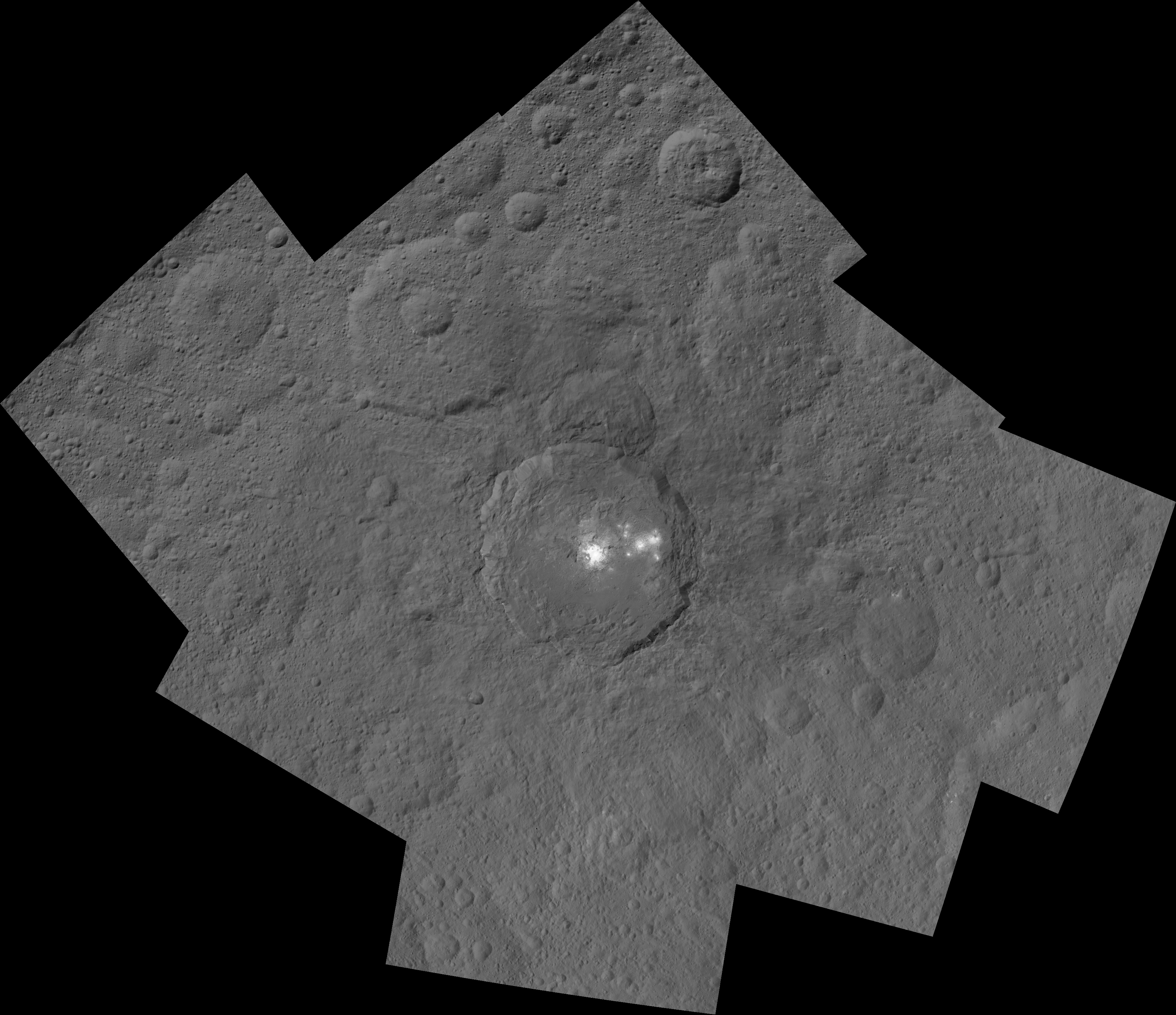
The science team has just released a new mosaic of the brightest spots on Ceres found at Occator crater and the surrounding terrain – see above.
The images were taken from the HAMO altitude of 915 miles (1,470 kilometers) during the first of six mapping cycles. They have a resolution of 450 feet (140 meters) per pixel.
Occator measures about 60 miles (90 kilometers) across and 2 miles (4 kilometers) deep.
This image, made using images taken by NASA’s Dawn spacecraft during the mission’s High Altitude Mapping Orbit (HAMO) phase, shows Occator crater on Ceres, home to a collection of intriguing bright spots. Credits: NASA/JPL-Caltech/UCLA/MPS/DLR/IDA
Because the spots are so bright they are generally overexposed. Therefore the team took two sets of images, with shorter and longer exposure times, to maximize the details of the interior of Occator.
“This view uses a composite of two images of Occator: one using a short exposure that captures the detail in the bright spots, and one where the background surface is captured at normal exposure.”
The bright spots at Occator crater remain the biggest Cerean mystery.
So far the imagery and other science data may point to evaporation of salty water from the interior as the source of the bright spots.
“Occasional water leakage on to the surface could leave salt there as the water would sublime,” Prof. Chris Russell, Dawn principal investigator told Universe Today exclusively.
“The big picture that is emerging is that Ceres fills a unique niche.”
“Ceres fills a unique niche between the cold icy bodies of the outer solar system, with their rock hard icy surfaces, and the water planets Mars and Earth that can support ice and water on their surfaces,” Russell, of the University of California, Los Angeles, told me.
Dawn has peeled back Ceres secrets as the spacecraft orbits lower and lower. Detailed measurements gathered to date have yielded global mineral and topographic maps from HAMO with the best resolution ever as the science team painstakingly stitched together the probes spectral and imaging products.
And the best is yet to come at LAMO.
At HAMO, Dawn’ instruments, including the Framing Camera and Visible and Infrared Spectrometer (VIR) were aimed at slightly different angles in each mapping cycle allowing the team to generate stereo views and construct 3-D maps.
“The emphasis during HAMO is to get good stereo data on the elevations of the surface topography and to get good high resolution clear and color data with the framing camera,” Russell explained.
This view from NASA’s Dawn spacecraft is a color-coded topographic map of Occator crater on Ceres. Blue is the lowest elevation, and brown is the highest. The crater, which is home to the brightest spots on Ceres, is approximately 56 miles (90 kilometers wide). Credits: NASA/JPL-Caltech/UCLA/MPS/DLR/IDA
Dawn is Earth’s first probe in human history to explore any dwarf planet, the first to explore Ceres up close and the first to orbit two celestial bodies.
The asteroid Vesta was Dawn’s first orbital target where it conducted extensive observations of the bizarre world for over a year in 2011 and 2012.
Ceres is a Texas-sized world, ranks as the largest object in the main asteroid belt between Mars and Jupiter, and may have a subsurface ocean of liquid water that could be hospitable to life.
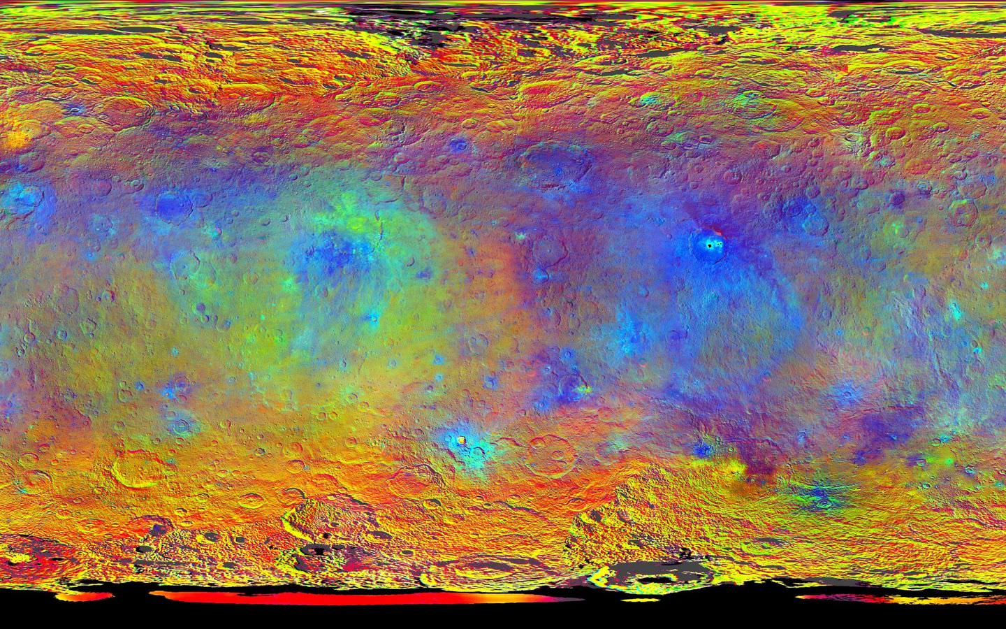
This map-projected view of Ceres was created from images taken by NASA’s Dawn spacecraft during its high-altitude mapping orbit, in August and September, 2015. This color coded map can provide valuable insights into the mineral composition of the surface, as well as the relative ages of surface features. Credits: NASA/JPL-Caltech/UCLA/MPS/DLR/IDA
The mission is expected to last until at least March 2016, and possibly longer, depending upon fuel reserves.
“It will end some time between March and December,” Dr. Marc Rayman, Dawn’s chief engineer and mission director based at NASA’s Jet Propulsion Laboratory, Pasadena, California, told Universe Today.
Stay tuned here for Ken’s continuing Earth and planetary science and human spaceflight news.
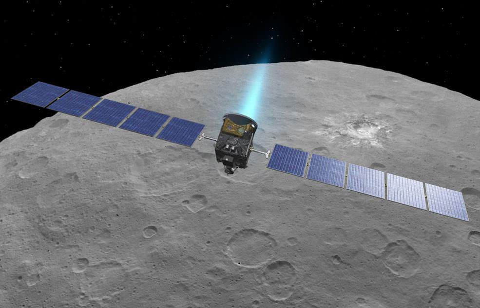
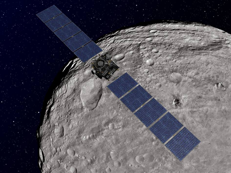
An artist’s conception shows NASA’s Dawn spacecraft flying above Ceres. This view incorporates actual imagery from the Dawn mission. Credit: NASA/JPL-Caltech/UCLA/MPS/DLR/IDA
This image, made using images taken by NASA's Dawn spacecraft during the mission's High Altitude Mapping Orbit (HAMO) phase, shows Occator crater on Ceres, home to a collection of intriguing bright spots. Credits: NASA/JPL-Caltech/UCLA/MPS/DLR/IDA
This image, made using images taken by NASA’s Dawn spacecraft during the mission’s High Altitude Mapping Orbit (HAMO) phase, shows Occator crater on Ceres, home to a collection of intriguing bright spots. Credits: NASA/JPL-Caltech/UCLA/MPS/DLR/IDA
Story/imagery updated[/caption]
Since scientists believe that Ceres occupies a “unique niche” in the solar system and apparently harbors subsurface ice or liquid oceans, could the bright spots arise from subsurface “water leakage?” To find out Universe Today asked Dawn’s Principal Investigator and Chief Engineer.
“The big picture that is emerging is that Ceres fills a unique niche,” Prof. Chris Russell, Dawn principal investigator told Universe Today exclusively.
“Ceres fills a unique niche between the cold icy bodies of the outer solar system, with their rock hard icy surfaces, and the water planets Mars and Earth that can support ice and water on their surfaces,” said Russell, of the University of California, Los Angeles.
And with Dawn recently arrived at its second lowest science mapping orbit of the planned mission around icy dwarf planet Ceres in mid-August, the NASA spacecraft is capturing the most stunningly detailed images yet of those ever intriguing bright spots located inside Occator crater.
The imagery and other science data may point to evaporation of salty water as the source of the bright spots.
“Occasional water leakage on to the surface could leave salt there as the water would sublime,” Russell told me.
Circling the Lights of Occator crater on Ceres. This image, made using images taken by NASA’s Dawn spacecraft during the mission’s High Altitude Mapping Orbit (HAMO) phase and draped over a shape model, shows Occator crater on Ceres, home to a collection of intriguing bright spots. The image has been stretched by 1.5 times in the vertical direction to better illustrate the crater’s topography. Credits: NASA/JPL-Caltech/UCLA/MPS/DLR/IDA
Dawn is Earth’s first probe to explore any dwarf planet and the first to explore Ceres up close. It was built by Orbital ATK.
To shed more light on what still remains rather mysterious even today, NASA has just released the best yet imagery, which was taken at Dawn’s High Altitude Mapping Orbit (HAMO) phase and they raise as many questions as they answer.
Occator has captured popular fascination world-wide because the 60 miles (90 kilometers) diameter crater is rife with the alien bodies brightest spots and whose nature remains elusive to this day, over half a year after Dawn arrived in orbit this past spring on March 6, 2015.
The new imagery from Dawn’s current HAMO mapping orbit was taken at an altitude of just 915 miles (1,470 kilometers). They provide about three times better resolution than the images captured from its previous orbit in June, and nearly 10 times better than in the spacecraft’s initial orbit at Ceres in April and May, says the team.
So with the new HAMO orbit images in hand, I asked the team what’s the latest thinking on the bright spots nature?
Initially a lot of speculation focused on water ice. But the scientists opinions have changed substantially as the data pours in from the lower orbits and forced new thinking on alternative hypotheses – to the absolute delight of the entire team!
“When the spots appeared at first to have an albedo approaching 100%, we were forced to think about the possibility of [water] ice being on the surface,” Russell explained.
“However the survey data revealed that the bright spots were only reflecting about 50% of the incoming light.”
“We did not like the ice hypothesis because ice sublimes under the conditions on Ceres surface. So we were quite relieved by the lower albedo.”
“So what could be 50% reflective? If we look at Earth we find that when water evaporates on the desert it leaves salt which is reflective. We know from its density that water or ice is inside Ceres.”
“So the occasional water leakage on to the surface could leave salt there as the water would sublime even faster than ice.”
At this time no one knows how deep the potential ice deposit or water reservoir sources of the “water leakage” reside beneath the surface, or whether the bright salt spots arose from past or current activity and perhaps get replenished or enlarged over time. To date there is no evidence showing plumes currently erupting from the Cerean surface.
Video Caption: Circling Occator Crater on Ceres. This animation, made using data from NASA’s Dawn spacecraft, shows the topography of Occator crater on Ceres. Credits: Credit: NASA/JPL-Caltech/UCLA/MPS/DLR/IDA/PSI
Dawn is an international science mission and equipped with a trio of state of the art science instruments from Germany, Italy and the US. They will elucidate the overall elemental and chemical composition and nature of Ceres, its bright spots and other wondrous geological features like the pyramidal mountain object.
I asked the PI and Chief Engineer to explain specifically how and which of the instruments is the team using right now at HAMO to determine the bright spots composition?
“The instruments that will reveal the composition of the spots are the framing camera [from Germany], the infrared spectrometer, and the visible spectrometer [both from the VIR instrument from Italy], replied Dr. Marc Rayman, Dawn’s chief engineer and mission director based at NASA’s Jet Propulsion Laboratory, Pasadena, California.
“Dawn arrived in this third mapping orbit [HAMO] on Aug. 13. It began this third mapping phase on schedule on Aug. 17.”
But much work remains to gather and interpret the data and discern the identity of which salts are actually present on Ceres.
“While salts of various sorts have the right reflectance, they are hard to distinguish from one another in the visible,” Russell elaborated to Universe Today.
“That is one reason VIR is working extra hard on the IR spectrum. Scientists are beginning to speculate on the salts. And to think about what salts could be formed in the interior.”
“That is at an early stage right now,” Russell stated.
“I know of nothing exactly like these spots anywhere. We are excited about these scientific surprises!”
Occator crater lies in Ceres northern hemisphere.
“There are other lines of investigation besides direct compositional measurement that will provide insight into the spots, including the geological context,” Rayman told Universe Today.
Each of Dawn’s two framing cameras is also outfitted with a wheel of 7 color filters, explained Joe Makowski, Dawn program manager from Orbital ATK, in an interview.
Different spectral data is gathered using the different filters which can be varied during each orbit.
“So far Dawn has completed 2 mapping orbit cycles of the 6 cycles planned at HAMO.”
Each HAMO mapping orbit cycle lasts 11 days and consists of 14 orbits lasting 19 hours each. Ceres is entirely mapped during each of the 6 cycles. The third mapping cycle just started on Wednesday, Sept. 9.
The instruments will be aimed at slightly different angle in each mapping cycle allowing the team to generate stereo views and construct 3-D maps.
“The emphasis during HAMO is to get good stereo data on the elevations of the surface topography and to get good high resolution clear and color data with the framing camera,” Russell explained.
“We are hoping to get lots of VIR IR data to help understand the composition of the surface better.”
“Dawn will use the color filters in its framing camera to record the sights in visible and infrared wavelengths,” notes Rayman.
“Dawn remains at HAMO until October 23. Then it begins thrusting with the ion propulsion thrusters to reach its lowest mapping orbit named LAMO [Low Altitude Mapping Orbit],” Makowski told me.
“Dawn will arrive at LAMO on December 15, 2015.”
That’s a Christmas present we can all look forward to with glee!
This image was taken by NASA’s Dawn spacecraft of dwarf planet Ceres on Feb. 19 from a distance of nearly 29,000 miles (46,000 kilometers). It shows that the brightest spot on Ceres has a dimmer companion, which apparently lies in the same basin. Image Credit: NASA/JPL-Caltech/UCLA/MPS/DLR/IDA
What is the teams reaction, interplay and interpretation regarding the mountains of new data being received from Dawn? How do the geologic processes compare to Earth?
“Dawn has transformed what was so recently a few bright dots into a complex and beautiful, gleaming landscape,” says Rayman. “Soon, the scientific analysis will reveal the geological and chemical nature of this mysterious and mesmerizing extraterrestrial scenery.”
“We do believe we see geologic processes analogous to those on Earth – but with important Cerean twists,” Russell told me.
“However we are at a point in the mission where conservative scientists are interpreting what we see in terms of familiar processes. And the free thinkers are imagining wild scenarios for what they see.”
“The next few weeks (months?) will be a time where the team argues amongst themselves and finds the proper compromise between tradition and innovation,” Russell concluded elegantly.
Among the highest features seen on Ceres so far is a mountain about 4 miles (6 kilometers) high, which is roughly the elevation of Mount McKinley in Alaska’s Denali National Park. Vertical relief has been exaggerated by a factor of five to help understand the topography. Credits: NASA/JPL-Caltech/UCLA/MPS/DLR/IDA/LPI
A batch of new results from Dawn at Ceres are expected to be released during science presentations at the European Planetary Science Congress 2015 being held in Nantes, France from 27 September to 2 October 2015.
The Dawn mission is expected to last until at least March 2016, and possibly longer, depending upon fuel reserves.
“It will end some time between March and December,” Rayman told me.
The science objectives in the LAMO orbit could be achieved as soon as March. But the team wants to extend operations as long as possible, perhaps to June or beyond, if the spacecraft remains healthy and has sufficient hydrazine maneuvering fuel and NASA funding to operate.
“We expect Dawn to complete the mission objectives at Ceres by March 2016. June is a the programmatic milestone for end of the nominal mission, effectively a time margin,” Makowski told Universe Today.
“The team is working to a well-defined exploration plan for Ceres, which we expect to accomplish by March, if all goes well.”
“At launch Dawn started with 45 kg of hydrazine. It has about 21 kg of usable hydrazine onboard as of today.”
“We expect to use about 15 kg during the nominal remaining mission,” Makowski stated.
Therefore Dawn may have roughly 5 kg or so of hydrazine fuel for any extended mission, if all goes well, that may eventually be approved by NASA. Of course NASA’s budget depends also on what is approved by the US Congress.
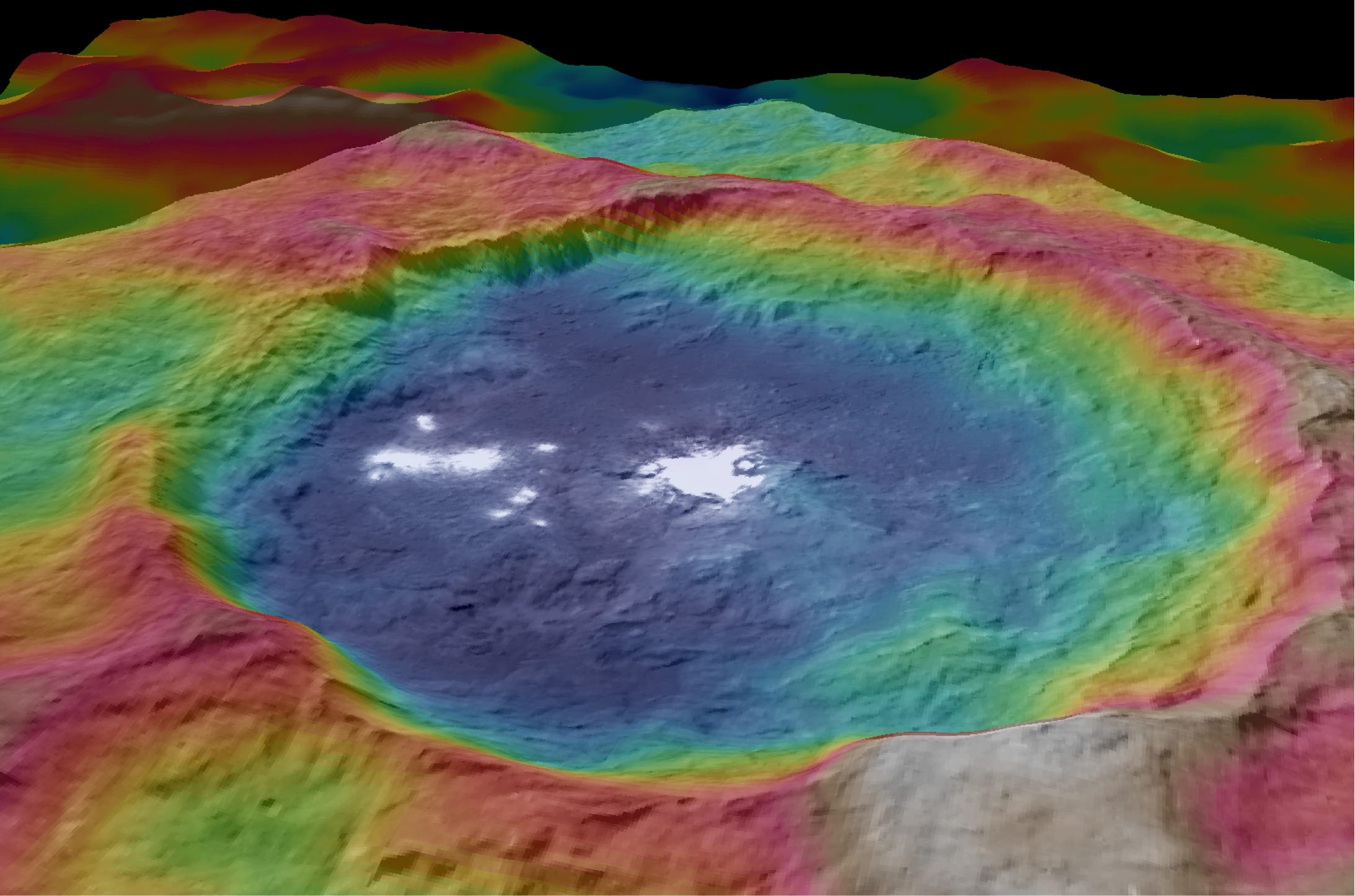
The intriguing brightest spots on Ceres lie in a crater named Occator, which is about 60 miles (90 kilometers) across and 2 miles (4 kilometers) deep. Vertical relief has been exaggerated by a factor of five. Exaggerating the relief helps scientists understand and visualize the topography much more easily, and highlights features that are sometimes subtle. Credits: NASA/JPL-Caltech/UCLA/MPS/DLR/IDA/LPI
Dawn was launched on September 27, 2007 by a United Launch Alliance (ULA) Delta II Heavy rocket from Space Launch Complex-17B (SLC-17B) at Cape Canaveral Air Force Station, Florida.
Stay tuned here for Ken’s continuing Earth and planetary science and human spaceflight news.
Dawn launch on September 27, 2007 by a United Launch Alliance Delta II Heavy rocket from Cape Canaveral Air Force Station, Florida. Credit: Ken Kremer/kenkremer.com
The intriguing brightest spots on Ceres lie in a crater named Occator, which is about 60 miles (90 kilometers) across and 2 miles (4 kilometers) deep. Vertical relief has been exaggerated by a factor of five. Exaggerating the relief helps scientists understand and visualize the topography much more easily, and highlights features that are sometimes subtle. Credits: NASA/JPL-Caltech/UCLA/MPS/DLR/IDA/LPI
Video caption: Take a tour of weird Ceres! Visit a 2-mile-deep crater and a 4-mile-tall mountain in the video narrated by mission director Marc Rayman. Get your red/blue glasses ready for the finale – a global view of the dwarf planet in 3D. Credits: NASA/JPL-Caltech/UCLA/MPS/DLR/IDA/LPI/PSI
Mysterious bright spots and a pyramidal shaped mountain star in a daunting new flyover video of dwarf planet Ceres created from imagery gathered by NASA’s history making Dawn mission – the first ever to visit any dwarf planet which simultaneously ranks as the largest world in the main asteroid belt residing between Mars and Jupiter.
Ceres was nothing more than a fuzzy blob to humankinds most powerful telescopes like the Hubble Space Telescope (HST), until the probe swooped in this year and achieved orbit on March 6, 2015.
The newly released, stunning video takes takes you on a tour like none before for a global cruise over the most fascinating features on Ceres – including the 2-mile-deep (4-km-deep) crater dubbed Occator and a towering 4-mile-tall (6 kilometer-tall) mountain as tall as any in North America.
The spectacular flyover animation was generated from high resolution images taken by Dawn’s framing camera during April and May and is narrated by Marc Rayman, Dawn Chief Engineer and Mission Director of NASA’s Jet Propulsion Laboratory, Pasadena, California.
The video concludes with a 3D view, so you’ll need to whip out your handy red/blue glasses for the finale – a global view of the dwarf planet in 3D.
From the orbital altitude at that time ranging from about 8,400 miles (13,600 kilometers) to 2,700 miles (4,400 kilometers), the highest-resolution regions on Ceres have a resolution of 1,600 feet (480 meters) per pixel.
Pockmarked Ceres is an alien world unlike any other in our solar system, replete with unexplained bright spots and craters of many sizes, large and small.
Occatur has captured popular fascination world-wide because the 60 miles (90 kilometers) diameter crater is rife with a host of the bodies brightest spots and whose nature remains elusive to this day, nearly half a year after Dawn arrived in orbit this past spring.
“Now, after a journey of 3.1 billion miles (4.9 billion kilometers) and 7.5 years, Dawn calls Ceres, home,” says Rayman.
The crater is named after the Roman agriculture deity of harrowing, a method of pulverizing and smoothing soil.
Dawn is an international science mission managed by NASA and equipped with a trio of science instruments from the US, Germany and Italy. The framing camera was provided by the Max Planck Institute for Solar System Research, Göttingen, Germany and the German Aerospace Center (DLR).
The visible and infrared mapping spectrometer (VIR), provided by Italy is an imaging spectrometer that examines Ceres in visible and infrared light.
Dawn’s science team is using the instruments to investigate the light reflecting from Occator at different wavelengths.
From a distance, the crater appeared to be home to a duo of bright spots that looked like a pair of eyes. As Dawn moves ever closer, they became more resolved and now are split into dozens of smaller bright spots.
Global view of Ceres uses data collected by NASA’s Dawn mission in April and May 2015. The highest-resolution parts of the map have a resolution of 1,600 feet (480 meters) per pixel. Credits: NASA/JPL-Caltech/UCLA/MPS/DLR/IDA/LPI/PSI
Although some early speculation centered on the spots possibly being consistent with water ice or salts, newly gathered data “has not found evidence that is consistent with ice. The spots’ albedo -¬ a measure of the amount of light reflected -¬ is also lower than predictions for concentrations of ice at the surface,” according to the scientists.
“The science team is continuing to evaluate the data and discuss theories about these bright spots at Occator,” said Chris Russell, Dawn’s principal investigator at the University of California, Los Angeles, in a statement.
“We are now comparing the spots with the reflective properties of salt, but we are still puzzled by their source. We look forward to new, higher-resolution data from the mission’s next orbital phase.”
Occator lies in Ceres northern hemisphere.
The huge pyramidal mountain lies farther to the southeast of Occator – at 11 degrees south, 316 degrees east.
Based on the latest calculations, the mountain sits about 4 miles (6 kilometers) high, with respect to the surface around it. That make it roughly the same elevation as Mount McKinley in Denali National Park, Alaska, the highest point in North America.
Among the highest features seen on Ceres so far is a mountain about 4 miles (6 kilometers) high, which is roughly the elevation of Mount McKinley in Alaska’s Denali National Park. Vertical relief has been exaggerated by a factor of five to help understand the topography. Credits: NASA/JPL-Caltech/UCLA/MPS/DLR/IDA/LPI
The Texas-sized world is slightly smaller than previously thought. Based on new measurements from Dawn, Ceres’ average diameter to 584 miles (940 kilometers), compared to earlier estimates of 590 miles (950 kilometers).
Dawn made history in March when it simultaneously became the first probe from Earth to reach Ceres as well as the first spacecraft to orbit two extraterrestrial bodies.
It had previously visited Vesta. After achieving orbit in July 2011, Dawn became the first spacecraft from Earth to orbit a body in the main Asteroid Belt.
In sharp contrast to rocky Vesta, Ceres is an icy world.
Scientists believe that Ceres may harbor an ocean of subsurface liquid water as large in volume as the oceans of Earth below a thick icy mantle despite its small size – and thus could be a potential abode for life. Overall Ceres is estimated to be about 25% water by mass.
“We really appreciate the interest in our mission and hope they are as excited as we have been about these scientific surprises,” Russell told Universe Today.
“Since we are only just beginning our investigation, I expect that there will be more surprises. So please stick with us!”
As Dawn spirals down to a lower orbit of about 1,200 miles (1,900 km) above Ceres (and then even lower) using its ion engines, new answers and new mysteries are sure to be forthcoming.
“There are many other features that we are interested in studying further,” said Dawn science team member David O’Brien, with the Planetary Science Institute, Tucson, Arizona.
“These include a pair of large impact basins called Urvara and Yalode in the southern hemisphere, which have numerous cracks extending away from them, and the large impact basin Kerwan, whose center is just south of the equator.”
The mission is expected to last until at least June 2016 depending upon fuel reserves.
Dawn was launched on September 27, 2007 by a United Launch Alliance (ULA) Delta II Heavy rocket from Space Launch Complex-17B (SLC-17B) at Cape Canaveral Air Force Station, Florida.
Stay tuned here for Ken’s continuing Earth and planetary science and human spaceflight news.
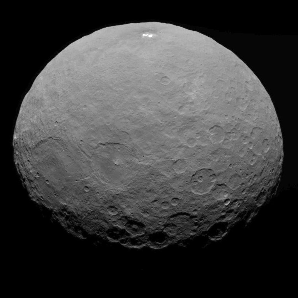
This image of Ceres was taken by NASA's Dawn spacecraft on May 7, 2015, from a distance of 8,400 miles (13,600 kilometers). Credit: NASA/JPL-Caltech/UCLA/MPS/DLR/IDA
Video caption: This new video animation of Ceres was created from images taken by NASA’s Dawn spacecraft at altitudes of 8,400 miles (13,600 kilometers) and 3,200 miles (5,100 kilometers) away. Vertical dimension has been exaggerated by a factor of two and a star field added. Credit: NASA/JPL-Caltech/UCLA/MPS/DLR/IDA
Scientists leading NASA’s Dawn mission to dwarf planet Ceres have just released a brand new animated video showing a dramatic fly over of the heavily cratered world featuring its mysterious bright spots whose exact origin and nature remain elusive.
Meanwhile, the venerable probe has just successfully entered its new and lower mapping orbit on June 3 from which researchers hope to glean hordes of new data to unravel the secrets of the bright spots and unlock the nature of Ceres origin and evolution.
Pockmarked Ceres is an alien world unlike any other in our solar system.
“Dawn completed the maneuvering to reach its second mapping orbit and stopped ion-thrusting on schedule. Since May 9, the spacecraft has reduced its orbital altitude from 8,400 miles (13,600 kilometers) to 2,700 miles (4,400 kilometers),” reported Marc Rayman, Dawn Chief Engineer/ Mission Director of NASA’s Jet Propulsion Laboratory, Pasadena, California.
“As Dawn flew 2,700 miles (4,400 kilometers) over Ceres’ north pole on June 5 that marked the beginning of the new mapping phase, and Dawn began taking photos and making other measurements on schedule.”
Each orbit of Dawn around Ceres at this second science mapping orbit lasts 3.1 days.
The new video was created by the research team based on observations of Ceres that were taken from Dawn’s initial mapping orbit, at an altitude of 8,400 miles (13,600 kilometers), as well as the most recent navigational images taken from 3,200 miles (5,100 kilometers), according to NASA.
It is based on data from over 80 images captured by Dawn’s framing cameras which were provided The German Aerospace Center (DLR) and Max Planck Institute for Solar System Research in Göttingen, Germany.
The images were used to provide a three-dimensional video view. The vertical dimension is exaggerated by a factor of two in the video.
“We used a three-dimensional terrain model that we had produced based on the images acquired so far,” said Dawn team member Ralf Jaumann of the German Aerospace Center (DLR), in Berlin.
“They will become increasingly detailed as the mission progresses — with each additional orbit bringing us closer to the surface.”
Imagery of the mysterious bright spots show them to seemingly be sheets of many spots of water ice, and not just single huge patches. The famous duo of ice spots are located inside the middle of a 57 miles (92 kilometers) wide crater situated in Ceres northern hemisphere.
Dawn is an international science mission managed by NASA’s Jet Propulsion Laboratory, Pasadena, California. The trio of science instruments are from the US, Germany and Italy.
The framing camera was provided by the Max Planck Institute for Solar System Research, Göttingen, Germany and the German Aerospace Center (DLR).
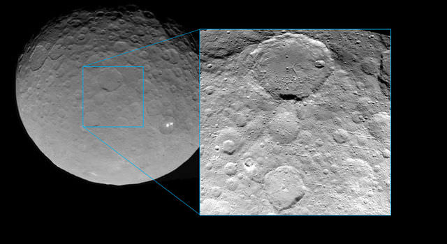
This view of Ceres was taken by Dawn spacecraft on May 23 and shows finer detail becoming visible on the dwarf planet. The spacecraft snapped the image at a distance of 3,200 miles (5,100 kilometers) with a resolution of 1,600 feet (480 meters) per pixel. Credit: NASA/JPL-Caltech/UCLA/MPS/DLR/IDA
Dawn will spend most if June at this second mapping orbit before firing up the ion engines and spiraling yet lower for a mission expected to last until at least June 2016.
Stay tuned here for Ken’s continuing Earth and planetary science and human spaceflight news.
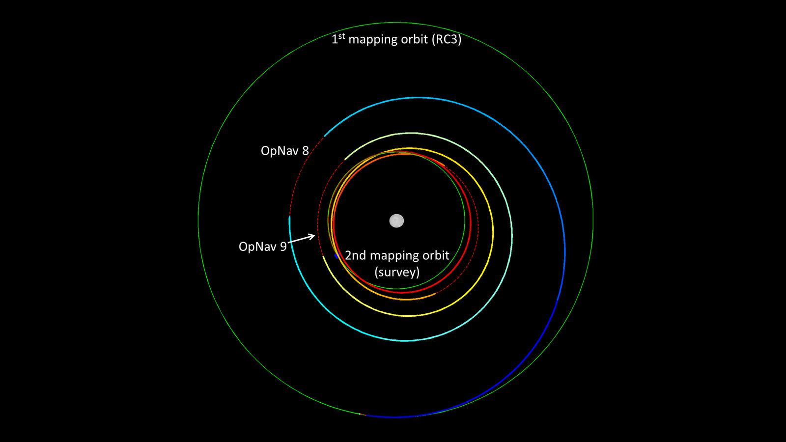
Dawn’s spiral descent from its first mapping orbit (RC3) to its second (survey). The two mapping orbits are shown in green. The color of Dawn’s trajectory progresses through the spectrum from blue, when it began ion-thrusting on May 9, to red, when ion-thrusting concludes on June 3. The red dashed sections show where Dawn is coasting, mostly for telecommunications. The first two coast periods include OpNav 8 and 9. Image credit: NASA/JPL-Caltech
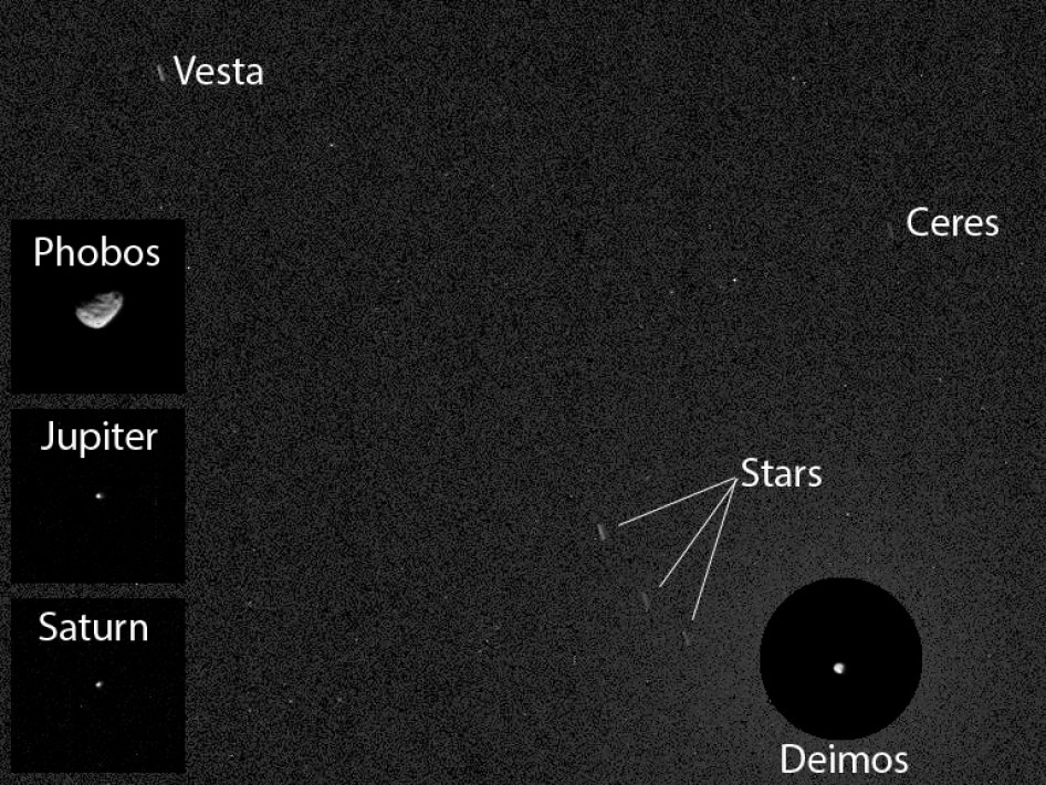
NASA's Curiosity Mars rover has caught the first image of asteroids taken from the surface of Mars. The image includes two asteroids, Ceres and Vesta. This version includes Mars' moon Deimos in a circular, exposure-adjusted inset and square insets at left from other observations the same night. Credit: NASA/JPL-Caltech/MSSS/Texas A&M
NASA’s Curiosity Mars rover has caught the first image of asteroids taken from the surface of Mars on April 20, 2014. The image includes two asteroids, Ceres and Vesta. This version includes Mars’ moon Deimos in a circular, exposure-adjusted inset and square insets at left from other observations the same night. Credit: NASA/JPL-Caltech/MSSS/Texas A&M
More night sky views and surface mosaics below[/caption]
The Curiosity rover has captured the first images of asteroids even taken by a Human probe from the alien surface of the Red Planet during night sky imaging.
And it’s not just one asteroid, but two asteroids caught in the same night time pointing on the Red Planet. Namely, asteroids Ceres and Vesta.
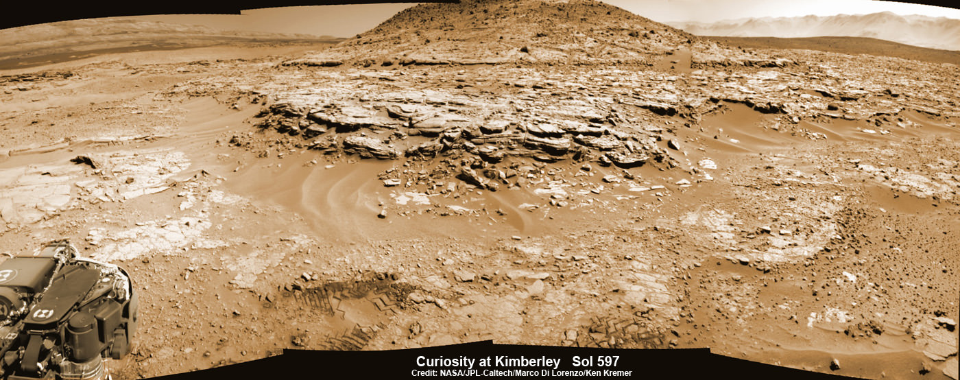
The stupendous image – seen above – was snapped by Curiosity’s high resolution Mastcam camera earlier this week on Sunday, April 20, 2014, Sol 606, whilst she was scanning about during daylight for her next drilling target at “The Kimberley” waypoint she pulled into at the start of this month.
Ceres and Vesta appear as streaks since the Mastcam image was taken as a 12 second time exposure.
“This imaging was part of an experiment checking the opacity of the atmosphere at night in Curiosity’s location on Mars, where water-ice clouds and hazes develop during this season,” said camera team member Mark Lemmon of Texas A&M University, College Station, in a statement.
“The two Martian moons were the main targets that night, but we chose a time when one of the moons was near Ceres and Vesta in the sky.”
View our “Kimberley” region photo mosiacs below to see exactly from where the six wheeled robot took the asteroid image shown above, while driving around the base of “Mount Remarkable”.
And those two asteroids are extra special because not only are they the two most massive objects in the Main asteroid belt between Mars and Jupiter, but they are also the destinations of another superlative NASA unmanned mission – Dawn.
Curiosity Mars rover captured this panoramic view of a butte called “Mount Remarkable” and surrounding outcrops at “The Kimberley ” waypoint on April 11, 2014, Sol 597. Colorized navcam photomosaic was stitched by Marco Di Lorenzo and Ken Kremer. Credit: NASA/JPL-Caltech/Marco Di Lorenzo/Ken Kremer – kenkremer.com
The exotic Dawn probe, propelled by a stream of ions, orbited Vesta for a year in 2011 and is now approaching Ceres for an exciting orbital mission in 2015.
Ceres, the largest asteroid, is about 590 miles (950 kilometers) in diameter. Vesta is the third-largest object in the main belt and measures about 350 miles (563 kilometers) wide.
And as if Curiosity’s mouthwatering and heavenly double asteroid gaze wasn’t already spectacular enough, the tinier of Mars’ moons, Deimos, was also caught in that same image.
A trio of star trails is also seen, again due to the 12 second time exposure time.
Furthermore, Mars largest moon Phobos as well as massive planets Jupiter and Saturn were also visible that same Martian evening, albeit in a different pointing.
These celestial objects are all combined in the composite image above.
“The background is detector noise, limiting what we can see to magnitude 6 or 7, much like normal human eyesight. The two asteroids and three stars would be visible to someone of normal eyesight standing on Mars. Specks are effects of cosmic rays striking the camera’s light detector,” says NASA.
An unannotated image is seen below.
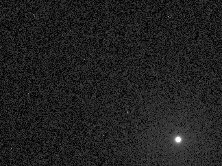
NASA’s Curiosity Mars rover has caught the first image of asteroids taken from the surface of Mars. The image includes two asteroids, Ceres and Vesta. In this unannotated version of the 12-second-exposure image, the brightness of Deimos at lower right saturates the image, making the moon appear overly large. Credit: NASA/JPL-Caltech/MSSS/Texas A&M
Curiosity’s makers back on Earth are nowhere to be seen. But check out the Curiosity’s earlier photo below of the Earth and Moon from my prior article – here.
To date, Curiosity’s odometer totals 3.8 miles (6.1 kilometers) since landing inside Gale Crater on Mars in August 2012. She has taken over 143,000 images.
The sedimentary foothills of Mount Sharp, which reaches 3.4 miles (5.5 km) into the Martian sky, is the 1 ton robots ultimate destination inside Gale Crater because it holds caches of water altered minerals. Such minerals could possibly indicate locations that sustained potential Martian life forms, past or present, if they ever existed. Martian landscape with rows of curved rock outcrops at ‘Kimberly’ in the foreground and spectacular Mount Sharp on the horizon. NASA’s Curiosity Mars rover pulled into Kimberly waypoint dominated by layered rock outcrops as likely drilling site. This colorized navcam camera photomosaic was assembled from imagery taken on Sol 576 (Mar. 20, 2014). Credit: NASA/JPL-Caltech/Marco Di Lorenzo/Ken Kremer-kenkremer.com
Curiosity has some 4 kilometers to go to reach the base of Mount Sharp sometime later this year.
Stay tuned here for Ken’s continuing Curiosity, Opportunity, Chang’e-3, SpaceX, Orbital Sciences, LADEE, MAVEN, MOM, Mars and more planetary and human spaceflight news.
You are here! – As an Evening Star in the Martian Sky
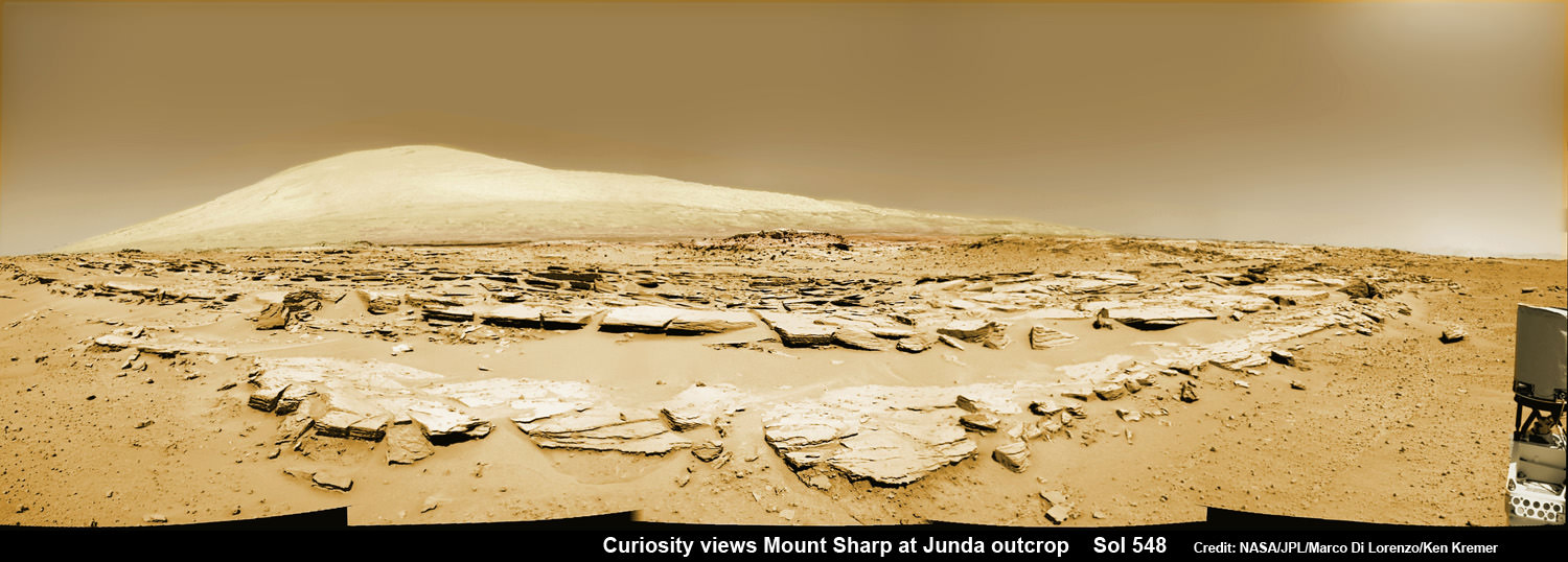
This evening-sky view taken by NASA’s Mars rover Curiosity shows the Earth and Earth’s moon as seen on Jan. 31, 2014, or Sol 529 shortly after sunset at the Dingo Gap inside Gale Crater. Credit: NASA/JPL-Caltech/MSSS/TAMUMars rock rows and Mount Sharp. Martian landscape scene with rows of striated rocks in the foreground and Mount Sharp on the horizon. NASA’s Curiosity Mars rover paused mid drive at the Junda outcrop to snap the component images for this navcam camera photomosaic on Sol 548 (Feb. 19, 2014) and then continued traveling southwards towards mountain base. UHF Antenna at right. Credit: NASA/JPL-Caltech/Marco Di Lorenzo/Ken Kremer-kenkremer.com
Image Caption: Divalia Fossa equatorial trough at Vesta pictured in side by side images showing apparent brightness and topography. The trough encircles most of Vesta and is located just south of the equator. It is about 10 kilometers (6 miles) wide. Rubria and Occia craters straddle Divalia Fossa. The image was snapped on Oct 16, 2011 from an altitude of 700 km (435 mi) from the HAMO mapping orbit. Image Credit: NASA/ JPL-Caltech/ UCLA/ MPS/ DLR/ IDA
“NASA’s Dawn mission to Asteroid Vesta is going exceptionally well”, Dr. Marc Rayman, the mission’s Chief Engineer, told Universe Today in an exclusive interview as the revolutionary spacecraft nears the end of its more than 1 year long super science survey orbiting the giant space rock.
“The Dawn mission is not only going better than we had expected but even better than we had hoped.”
Dawn is Earth’s first mission ever to orbit and explore Vesta up close.
“We have acquired so much more data than we had planned even in late 2011! We have conducted a tremendous exploration of Vesta – the second most massive body between Mars and Jupiter, a giant of the main asteroid belt.”
“Now we are in our second high altitude mapping orbit (HAMO2), which is the final intensive campaign of the Vesta mission,” Rayman told me.
Image Caption: Dawn Orbiting Vesta above the “Snowman” craters. This artist’s concept shows NASA’s Dawn spacecraft orbiting the giant asteroid Vesta above the Snowman craters. The depiction of Vesta is based on images obtained by Dawn’s framing cameras. Dawn is an international collaboration of the US, Germany and Italy. Credit: NASA/JPL-Caltech
Indeed Dawn’s science and maneuvering endeavour’s at Vesta have proceeded so flawlessly that NASA has granted the science team a bonus of 40 days additional time in orbit split between the lower and higher science orbits known as LAMO and HAMO or the Low Altitude Mapping Orbit and the High Altitude Mapping Orbit respectively.
“Our original Vesta departure date was July 17, and now it is about August 26.” Rayman explained.
The bonus time at LAMO has already been completed. Now the team is about to begin the bonus time at HAMO – consisting of two additional mapping cycles beyond the four originally planned.
Each mapping cycle in HAMO2 consists of 10 orbits. Each orbit is about 12.5 hours.
“On July 14, we will complete mapping cycle 4 and begin 5 (of 6). On July 25 we will leave HAMO2 and escape from orbit on August 26. We will stop thrusting several times before escape to take more neat pictures, mostly of the northern hemisphere,” Rayman told me.
“As Dawn revolves, Vesta rotates on its axis beneath it, turning once every 5.3 hours.”
When Dawn arrived in orbit at Vesta in July 2011 the northern polar region was in darkness as the southern hemisphere basked in summer’s glow. Now as Dawn departs Vesta in August, virtually all of the previously unseen and unphotographed northern polar region is illuminated and will be mapped in exquisite detail.
Coincidentally on July 13/14 as HAMO2 Cycle 4 ends, I’ll be presenting a free public lecture about Dawn and NASA’s Planetary and Human Spaceflight programs at the Adirondack Public Observatory.
Image Caption: Asteroid Vesta and Mysterious Equatorial Grooves – from Dawn Orbiter. This full view of the giant asteroid Vesta was taken by NASA’s Dawn spacecraft on July 24, 2011, at a distance of 3,200 miles (5,200 kilometers). This view shows impact craters of various sizes and mysterious grooves parallel to the equator. The resolution of this image is about 500 meters per pixel. Credit: NASA/JPL-Caltech/UCLA/MPS/DLR/IDA
Why has Dawn been granted an extended mission ?
“Dawn has gone so well that we had consumed not even one day of our 40 days of operations margin,” Rayman stated .
“That allowed us to spend more time in LAMO. We had had some unexpected events to be sure, but we managed to deal with all of them so expeditiously that the entire margin remained intact. Then we received the (entirely unrelated) 40 day extension, which allowed us to leave Vesta later. That came about because of our being able to shorten the flight from Vesta to Ceres, so we could still reach Ceres on schedule in 2015.”
“That 40 days allowed us to spend still ~ 30 more days in LAMO and increase HAMO2 by 10 days to a total of six cycles. We got still more time by finding ways to make the trip from HAMO2 to escape a little more efficiently, and that’s what allowed HAMO2 to be even longer, with the additional eight days of VIR-only observations I described in my most recent Dawn Journal.”
“The summary is that every investigation has been more productive than we could have imagined, and because the exploration of Vesta has gone so well, we have been able to apply our unused margin to get even more out of the mission. It is very very gratifying and exciting.”
So we have a few more weeks to enjoy the wondrous sights of Vesta before Dawn fires up her revolutionary ion thrusters to escape the gravitational tug of Vesta and head off to the dwarf planet Ceres, the largest asteroid in the main belt of our Solar System – and which some have speculated may hold vast caches of water and perhaps even liquid oceans suitable for sustaining life.
…..
July 13/14: Free Public Lectures about NASA’s Mars, Vesta and Planetary Exploration, the Space Shuttle, SpaceX , Orion and more by Ken Kremer at the Adirondack Public Observatory in Tupper Lake, NY.
Vesta imaged by NASA’s Dawn Asteroid Orbiter. Dawn is currently at work at the Low Altitude Mapping Orbit (LAMO) acquiring new imagery and spectra of much higher resolution compared to these images acquired at higher altitudes and is also filling in gaps of surface data. The image from Dawn’s Framing Camera, at left, was taken on July 24 at a distance of 3,200 miles soon after achieving orbit around Vesta. The mosaic from Dawn’s Visible and infrared spectrometer (VIR), at right, was acquired from High-altitude mapping orbit (HAMO). Credit: NASA/ JPL-Caltech/ UCLA/ ASI/ INAF/ IAPS. Collage: Ken Kremer
[/caption]
NASA’s Dawn mission is getting a whopping boost in science observing time at the closest orbit around Asteroid Vesta as the probe passes the midway point of its 1 year long survey of the colossal space rock. And the team informs Universe Today that the data so far have surpassed all expectations and they are very excited !
Dawn’s bonus study time amounts to an additional 40 days circling Vesta at the highest resolution altitude for scientific measurements. That translates to a more than 50 percent increase beyond the originally planned length of 70 days at what is dubbed the Low Altitude Mapping Orbit, or LAMO.
“We are truly thrilled to be able to spend more time observing Vesta from low altitude,” Dr. Marc Rayman told Universe Today in an exclusive interview. Rayman is Dawn’s Engineer at NASA’s Jet Propulsion Laboratory (JPL) in Pasadena, Calif.
“It is very exciting indeed to obtain such a close-up look at a world that even a year ago was still just a fuzzy blob.”
The big extension for a once-in-a-lifetime shot at up close science was all enabled owing to the hard work of the international science team in diligently handling any anomalies along the pathway through interplanetary space and since Dawn achieved orbit in July 2011, as well as to the innovative engineering of the spacecraft’s design and its revolutionary ion propulsion system.
“This is a reflection of how well all of our work at Vesta has gone from the beginning of the approach phase in May 2011,” Rayman told me.
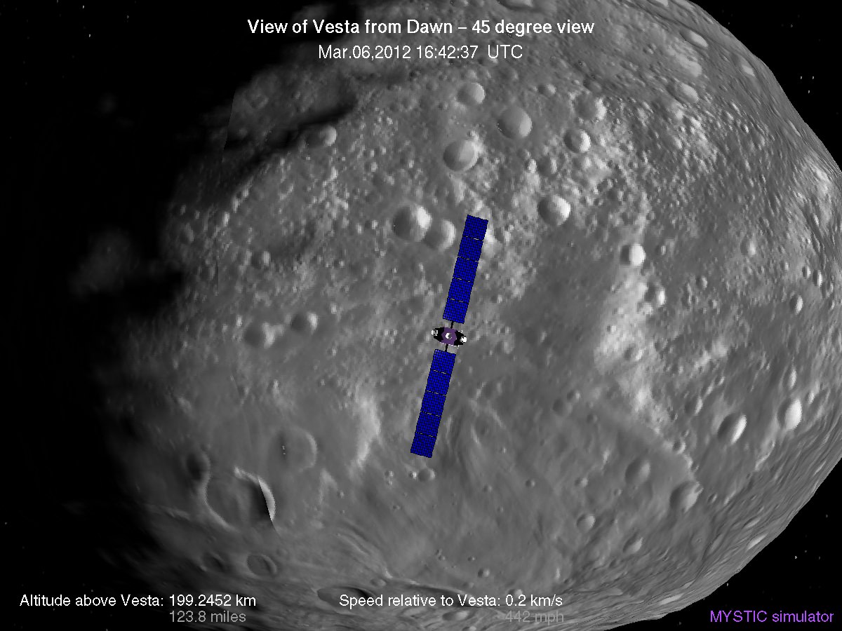
Simulated view of Vesta from Dawn in LAMO, low altitude mapping orbit - March, 6 2012
Credit: Gregory J. Whiffen, JPL
Dawn’s initially projected 10 week long science campaign at LAMO began on Dec. 12, 2011 at an average distance of 210 kilometers (130 miles) from the protoplanet and was expected to conclude on Feb. 20, 2012 under the original timeline. Thereafter it would start spiraling back out to the High Altitude Mapping Orbit, known as HAMO, approximately 680 kilometers above the surface.
“With the additional 40 days it means we are now scheduled to leave LAMO on April 4. That’s when we begin ion thrusting for the transfer to HAMO2,” Rayman stated.
And the observations to date at LAMO have already vastly surpassed all hopes – using all three of the onboard science instruments provided by the US, Germany and Italy.
“Dawn’s productivity certainly is exceeding what we had expected,” exclaimed Rayman.
“We have acquired more than 7500 LAMO pictures from the Framing Camera and more than 1 million LAMO VIR (Visible and Infrared) spectra which afford scientists a much more detailed view of Vesta than had been planned with the survey orbit and the high altitude mapping orbit (HAMO). It would have been really neat just to have acquired even only a few of these close-up observations, but we have a great bounty!”
“Roughly around half of Vesta’s surface has been imaged at LAMO.”
Dawn mosaic of Visible and Infrared spectrometer (VIR) data of Vesta
This mosaic shows the location of the data acquired by VIR (visible and infrared spectrometer) during the HAMO (high-altitude mapping orbit) phase of the Dawn mission from August to October 2011. Dawn is now making the same observations at the now extended LAMO (low-altitude mapping orbit) phase of the Dawn mission from December 2011 to April 2012. VIR can image Vesta in a number of different wavelengths of light, ranging from the visible to the infrared part of the electromagnetic spectrum. This mosaic shows the images taken at a wavelength of 550 nanometers, which is in the visible part of the electromagnetic spectrum. During HAMO VIR obtained more than 4.6 million spectra of Vesta. It is clear from this image that the VIR observations are widely distributed across Vesta, which results in a global view of the spectral properties of Vesta’s surface. This image shows Vesta’s southern hemisphere (lower part of the image) and equatorial regions (upper part of the image). NASA’s Dawn spacecraft obtained these VIR images with its visible and infrared spectrometer in September and October 2011. The distance to the surface of Vesta is around 700 kilometers (435 miles) and the average image resolution is 170 meters per pixel. Credit: NASA/ JPL-Caltech/ UCLA/ ASI/ INAF/ IAPS
The bonus time at LAMO will now be effectively used to help fill in the gaps in surface coverage utilizing all 3 science instruments. Therefore perhaps an additional 20% to 25% extra territory will be imaged at the highest possible resolution. Some of this will surely amount to enlarged new coverage and some will be overlapping with prior terrain, which also has enormous research benefits.
“There is real value even in seeing the same part of the surface multiple times, because the illumination may be different. In addition, it helps for building up stereo,” said Rayman.
Researchers will deduce further critical facts about Vesta’s topography, composition, interior, gravity and geologic features with the supplemental measurements.
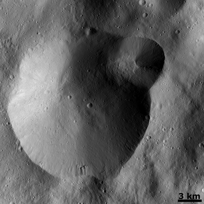
Successive formation of impact craters on Vesta
This Dawn FC (framing camera) image shows two overlapping impact craters and was taken on Dec. 18,2011 during the LAMO (low-altitude mapping orbit) phase of the mission. The large crater is roughly 20 kilometers (12 miles) in diameter and the smaller crater is roughly 6 kilometers (4 miles) in diameter. The rims of the craters are both reasonably fresh but the larger crater must be older because the smaller crater cuts across the larger crater’s rim. As the smaller crater formed it destroyed a part of the rim of the pre-existing, larger crater. The larger crater’s interior is more densely cratered than the smaller crater, which also suggests that is it older. In the bottom of the image there is some material slumping from rim of the larger crater towards its center. This image with its framing camera on Dec. 18, 2011. This image was taken through the camera’s clear filter. The distance to the surface of Vesta is 260 kilometers (162 miles) and the image has a resolution of about 22 meters (82 feet) per pixel. Credit: NASA/ JPL-Caltech/ UCLA/ MPS/ DLR/ IDA
The foremost science goals at LAMO are collection of gamma ray and neutron measurements with the GRaND instrument – which focuses on determining the elemental abundances of Vesta – and collection of information about the structure of the gravitational field. Since GRaND can only operate effectively at low orbit, the extended duration at LAMO takes on further significance.
“Our focus is on acquiring the highest priority science. The pointing of the spacecraft is determined by our primary scientific objectives of collecting GRaND and gravity measurements.”
As Dawn continues orbiting every 4.3 hours around Vesta during LAMO, GRaND is recording measurements of the subatomic particles that emanate from the surface as a result of the continuous bombardment of cosmic rays and reveals the signatures of the elements down to a depth of about 1 meter.
“You can think of GRaND as taking a picture of Vesta but in extremely faint light. That is, the nuclear emissions it detects are extremely weak. So our long time in LAMO is devoted to making a very, very long exposure, albeit in gamma rays and neutrons and not in visible light,” explained Rayman.
Now with the prolonged mission at LAMO the team can gather even more data, amounting to thousands and thousands more pictures, hundreds of thousands of more VIR spectra and ultra long exposures by GRaND.
“HAMO investigations have already produced global coverage of Vesta’s gravity field,” said Sami Asmar, a Dawn co-investigator from JPL. Extended investigations at LAMO will likewise vastly improve the results from the gravity experiment.
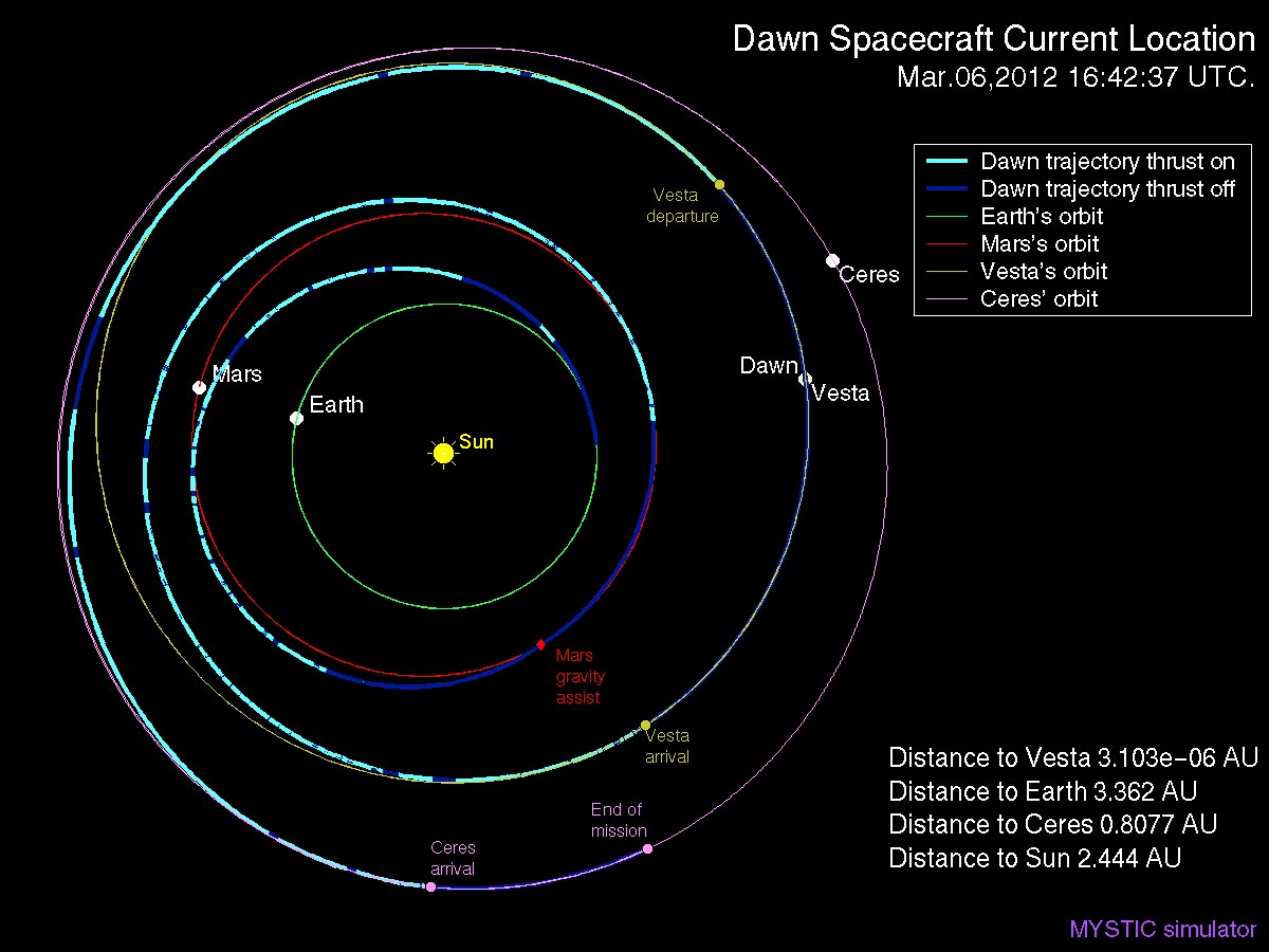
Dawn Spacecraft Current Location and Trajectory - March, 6 2012. Credit: Gregory J. Whiffen, JPL
“We always carried 40 days of “margin,” said Rayman, “but no one who was knowledgeable about the myriad challenges of exploring this uncharted world expected we would be able to accomplish all the complicated activities before LAMO without needing to consume some of that margin. So although we recognized that we might get to spend some additional time in LAMO, we certainly did not anticipate it would be so much.”
“As it turned out, although we did have surprises the operations team managed to recover from all of them without using any of those 40 days.”
“This is a wonderful bonus for science,” Rayman concluded.
“We remain on schedule to depart Vesta in July 2012, as planned for the past several years.”
Dawn’s next target is Ceres, the largest asteroid in the main Asteroid Belt between Mars and Jupiter
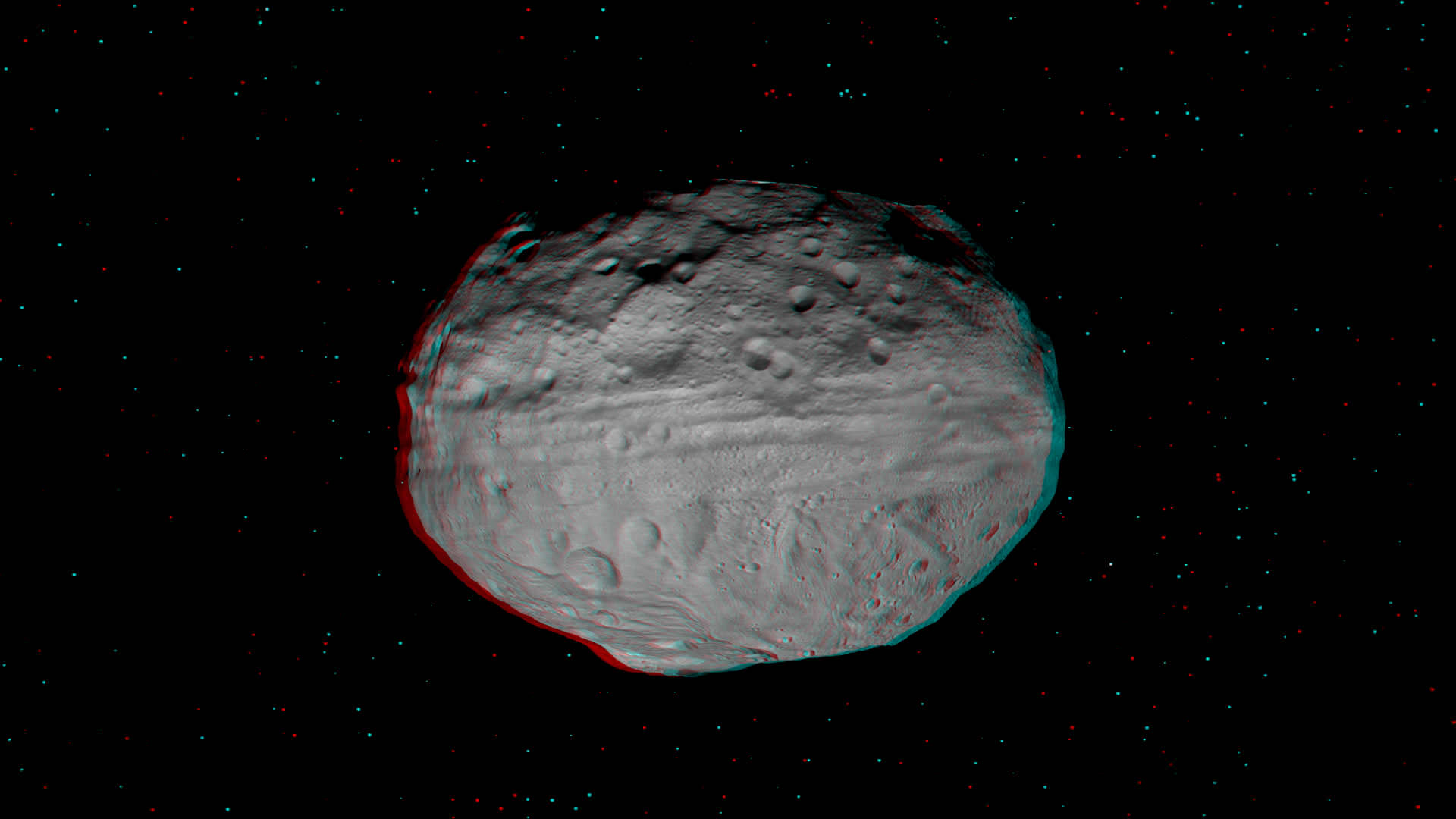
Vesta’s Eastern Hemisphere Floats in Space in 3-D. This anaglyph shows the varied topography of Vesta’s eastern hemisphere from craters in the north, the equatorial troughs and the huge mountain at the Souh Pole. Credit: NASA/JPL-Caltech/UCLA/MPS/DLR/IDA.
[/caption]
The giant Asteroid Vesta literally floats in space in a new high resolution 3-D image of the battered bodies Eastern Hemisphere taken by NASA’s Dawn Asteroid Orbiter.
Haul out your red-cyan 3-D anaglyph glasses and lets go whirling around Vesta and sledding down mountains to greet the alien Snowman! The sights are fabulous !
The Dawn imaging group based at the German Aerospace Center (DLR), in Berlin, Germany and led by team member Ralf Jaumann has released a trio of new high resolution 3-D images that are the most vivid anaglyphs yet published by the international science team.
The lead anaglyph shows the highly varied topography of the Eastern Hemisphere of Vesta and was taken during the final approach phase as Dawn was about 5,200 kilometers (3,200 miles) away and preparing to achieve orbit in July 2011.
The heavily cratered northern region is at top and is only partially illuminated because of Vesta’s tilted angle to the Sun at that time of year. Younger craters are overlain onto many older and more degraded craters. The equatorial region is dominated by the mysterious troughs which encircle most of Vesta and may have formed as a result of a gargantuan gong, eons ago.
The southern hemisphere exhibits fewer craters than in the northern hemisphere. Look closely at the bottom left and you’ll see the huge central mountain complex of the Rheasilvia impact basin visibly protruding out from Vesta’s south polar region.
This next 3-D image shows a close-up of the South Pole Mountain at the center of the Rheasilvia Impact basin otherwise known as the “Mount Everest of Vesta”.
The Mount Everest of Vesta in 3-D
This anaglyph shows the central complex and huge mountain in Vesta’s Rheasilvia impact basin at the South Pole. Does water ice lurk beneath the South Pole ?
Credit: NASA/JPL-Caltech/UCLA/MPS/DLR/IDA.
The central complex is approximately 200 kilometers (120 miles) in diameter and is approximately 20 kilometers (12 miles) tall and is therefore about two and a half times taller than Earth’s Mount Everest!
Be sure to take a long look inside the deep craters and hummocky terrain surrounding “Mount Everest”.
A recent study concludes that, in theory, Vesta’s interior is cold enough for water ice to lurk beneath the North and South poles.
Finally lets gaze at the trio of craters that make up the “Snowman” in the 3-D image snapped in August 2011 as Dawn was orbiting at about 2,700 kilometers (1,700 miles) altitude. The three craters are named Minucia, Marcia and Calpurnia from top to bottom. Their diameters respectively are; 24 kilometers (15 miles), 53 kilometers (33 miles) and 63 kilometers (40 miles).
3-D image of Vesta’s “Snowman” craters
The three craters are named Minucia, Marcia and Calpurnia from top to bottom. They are 24 kilometers (15 miles), 53 kilometers (33 miles) and 63 kilometers (40 miles) in diameter, respectively. Image resolution is about 250 meters (820 feet) per pixel. Credit: NASA/JPL-Caltech/UCLA/MPS/DLR/IDA.
It is likely that Marcia and Calpurnia formed from the impact of a binary asteroid and that Minucia formed in a later impact. The smooth region around the craters is the ejecta blanket.
Dawn Orbiting Vesta above the “Snowman” craters
This artist's concept shows NASA's Dawn spacecraft orbiting the giant asteroid Vesta above the Snowman craters. The depiction of Vesta is based on images obtained by Dawn's framing cameras. Dawn is an international collaboration of the US, Germany and Italy. Credit: NASA/JPL-Caltech
Vesta is the second most massive asteroid in the main Asteroid Belt between Mars and Jupiter. It is 330 miles (530 km) in diameter.
Dawn is the first spacecraft from Earth to visit Vesta. It achieved orbit in July 2011 for a year long mission. Dawn will fire up its ion propulsion thrusters in July 2012 to spiral out of orbit and sail to Ceres, the biggest asteroid of them all !
Vesta and Ceres are also considered to be protoplanets.