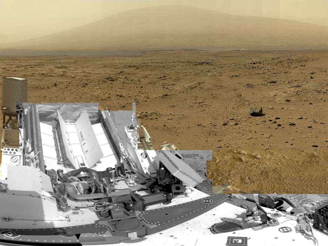
This is a cropped, reduced version of panorama from NASA's Mars rover Curiosity with 1.3 billion pixels in the full-resolution version. See full panorama below. It shows Curiosity at the "Rocknest" site where the rover scooped up samples of windblown dust and sand. Curiosity used three cameras to take the component images on several different days between Oct. 5 and Nov. 16, 2012. Viewers can explore this image with pan and zoom controls at http://mars.nasa.gov/bp1/. Credit: NASA/JPL-Caltech/MSSS
Updated with link to interactive Gigapan version
[/caption]
NASA's
newly produced and absolutely spectacular panorama from the
Curiosity mega rover
offers armchair explorers back on Earth a mammoth 1.3 billion pixels worth of
Mars
in all its colorful glory.
And everyone can move back and forth around the interactive panorama and zoom in - with special embedded tools- to your hearts delight in exquisite detail at the 'Rocknest' site where the rover spent her first extended science stay in late 2012.
This extra special Rocknest panorama is the first NASA- produced view comprising more than a billion pixels from the surface of
the Red Planet
.
It offers a full 360 degree panoramic view around the rover encompassing breathtaking vistas of Mount Sharp and the eerie rim of Gale Crater, some 20 miles distant.
Mount Sharp rises 3.4 miles (5.5 km) high and is the target destination. The team hopes
Curiosity
will arrive at the base of Mount Sharp perhaps late this year or early in 2014.
The 'Rocknest' scene was assembled from nearly 900 raw images snapped by three different cameras among the 17 total that Curiosity uses as she trundles across the crater floor in search of the
ingredients of life
.
[caption id="attachment_103053" align="aligncenter" width="580"]
Billion-Pixel View From Curiosity at Rocknest, Raw Color. This full-circle, reduced view combined nearly 900 images taken by NASA's Curiosity Mars rover, generating a panorama with 1.3 billion pixels in the full-resolution version. The view is centered toward the south, with north at both ends. It shows Curiosity at the "Rocknest" site where the rover scooped up samples of windblown dust and sand. Curiosity used three cameras to take the component images on several different days between Oct. 5 and Nov. 16, 2012. Credit: NASA/JPL-Caltech/MSSS[/caption]
The panorama was created by Bob Deen of the Multi-Mission Image Processing Laboratory at NASA's Jet Propulsion Laboratory, Pasadena, Calif, where the mission is managed on a daily basis.
"It gives a sense of place and really shows off the cameras' capabilities," said Deen in a statement. "You can see the context and also zoom in to see very fine details."
Check here for the full, billion pixel interactive
cylindrical
and
panoramic
viewers
Download the full image -
here
.
"Rocknest" was a windblown ripple of sand dunes that
Curiosity
drove to after departing from the touchdown site at 'Bradbury Landing' and thoroughly investigated in October and November 2012.
It was at 'Rocknest' where the six wheeled rover famously deployed her robotic arm to scoop into the
Martian
dirt for the very first time and then delivered those first grains to the duo of analytical chemistry labs inside her belly that lie at the heart of Curiosity's science mission.
Deen assembled the color product using 850 raw images from the 100 mm telephoto camera of
Curiosity's
Mast Camera instrument, supplemented with 21 more from the Mastcam's wider-angle 34 mm camera.
In order to take in the rover itself, the view also included 25 black-and-white raw images from the Navigation Camera on the Mast.
All the images were taken between Oct. 5 and Nov. 16, 2012 while the rover was stationary at Rocknest.
Link to the interactive GigaPan version -
here
And check this link to a new NASA JPL Curiosity gallery on the GigaPan website -
here
Because the images were captured over many days and at different times of day, the lighting and atmospheric clarity varies - especially in distant views to the crater rim.
Since landing on August 6, 2012, Curiosity has already accomplished her primary goal of finding a habitable zone at Gale Crater with an environment that could once of supported Martian microbial life - at the current worksite at 'Yellowknife Bay.'
[caption id="attachment_103054" align="aligncenter" width="580"]
Time lapse context view of Curiosity maneuvering her robotic arm to conduct close- up examination of windblown 'Rocknest' ripple site. Curiosity inspects "bootlike" wheel scuff mark with the APXS (Alpha Particle X-Ray Spectrometer) and MAHLI (Mars Hand Lens Imager) instruments positioned on the rotatable turret at the arm's terminus. Mosaic stitched from Navcam images on Sols 57 & 58 shows the arm in action just prior to 1st sample scooping here. Eroded rim of Gale Crater rim is visible on the horizon. Credit: NASA/JPL-Caltech/Ken Kremer (kenkremer.com)/Marco Di Lorenzo[/caption]
The 1 ton robot is equipped with 10 state-of-the-art science instruments with research capabilities that far surpass any prior landed mission and is in the middle of the 2-year primary mission to
the Red Planet
.
Meanwhile, Curiosity's older sister rover
Opportunity
has also discovered clay minerals and a habitable zone on the opposite side of the Red Planet - details
here
.
And don't forget to "Send Your Name to Mars" aboard NASA's MAVEN orbiter- details
here
. Deadline: July 1, 2013
Ken Kremer
……………. Learn more about Mars, Curiosity, Opportunity, MAVEN, LADEE and NASA missions at Ken's upcoming lecture presentations
June 23: "Send your Name to Mars on MAVEN" and "CIBER Astro Sat, LADEE Lunar &
Antares
Rocket
Launches
from Virginia"; Rodeway Inn, Chincoteague, VA, 8 PM
[caption id="attachment_103055" align="aligncenter" width="580"]
Curiosity scooped 5 times into Martian soil at Rocknest windblown ripple and delivered samples to the SAM chemistry instrument for analysis. This color mosaic was stitched together from hi-res color images taken by the robots 34 mm Mastcam camera on Sols 93 and 74. Credit: NASA / JPL-Caltech /MSSS/Ken Kremer (kenkremer.com)/Marco Di Lorenzo[/caption]
 Universe Today
