Hurricane Ike is bearing down on the US gulf coast, and even before landfall, is causing problems. Nearly 1 million people along the Texas coast have been ordered to evacuate, the other 3 million people in the Houston metro area have been asked not to leave, in hopes of avoiding the panic of three years ago, when evacuations ordered in advance of Hurricane Rita sent millions onto highways causing traffic jams and deadly accidents. The airports in Houston will close tomorrow, and NASA's Johnson Space Center closed today.
[caption id="attachment_17989" align="alignnone" width="226" caption="Image of Ike taken from the ISS. Credit: NASA"]
[/caption] Astronauts on board the International Space Station had this view of Ike from their orbital perch 220 statute miles above the Earth. (See below for a larger, close-up image.) Mission managers for the ISS have taken up residence in a hotel far inland, armed with laptops and a secure high speed internet connection in order to maintain contact with the orbiting space station. Ike is currently a Category 2 hurricane according to the National Hurricane Center, but forecasters were predicting that Ike might reach Category 3 strength in the warm waters of the Gulf prior to its projected landfall on the central Texas coastline.
TRMM (Tropical Rainfall Measuring Mission) spacecraft observed this view of Hurricane Ike on September 10, 2008 at 1745 UTC. The storm was a category 2 hurricane with sustained winds of 85 knots (97.75 mph) and a pressure reading of 958 millibars. At this time, the storm has two nearby well-defined wind maxima of roughly equal strength. There is a 17 km tower in the outer eye.
Click here
for an animation from the TRMM spacecraft data.
The astronauts on board the International Space Station had this incredible view of the hurricane as it approached the Gulf Coast.
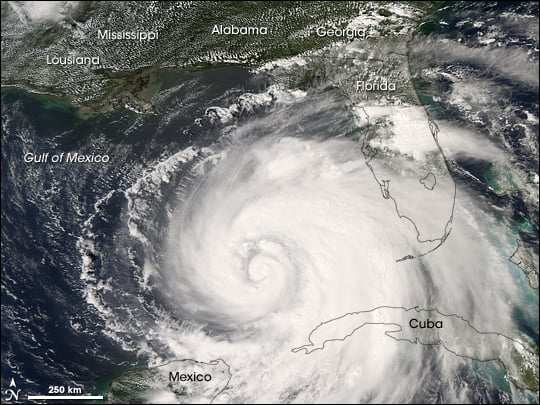
Ike was a Category 4 storm before its passage over Cuba stripped it of some of its power. It re-emerged in the Gulf of Mexico as a Category 1 storm and re-strengthened.
As of 10:00 a.m., Sept. 11, hurricane warnings are up from Morgan City Louisiana to Baffin Bay, Texas. Hurricane conditions could reach the coast within the warning area by late Friday, Sept. 12.
Ike is a Category 2 hurricane with maximum sustained winds near 100 mph. He is forecast to strengthen to a Category 3 storm before reaching the Texas coastline. Ike is moving west-northwest near 10 mph and will be near the coast late on Sept. 12, however, because Ike is large, tropical storm force winds will be felt far in advance.
Sources:
NASA's ISS Page
, NASA Earth Observatory Page, The Weather Channel. Here are even more hurricane photos and hurricane images.