[/caption]
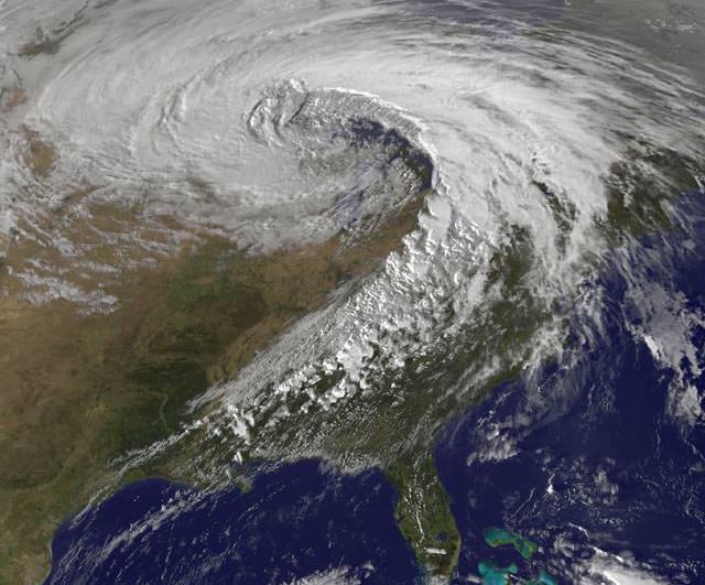
Yowza! – Here's a satellite image of a storm of record-breaking proportions. On October 26, 2010, the strongest storm ever recorded in the Midwest spawned 24 tornadoes, 282 reports of damaging winds, violent thunderstorms, and torrential rains. The mega-storm reached peak intensity late yesterday afternoon over Minnesota, resulting in the lowest barometric pressure readings ever recorded in the continental United States (except for from hurricanes and nor'easters affecting the Atlantic seaboard.) The storm continues today (Oct. 27) with more tornado watches posted for Mississippi, Alabama, and Georgia, a blizzard warning for North Dakota, high wind warnings for most of the upper Midwest, and near-hurricane force winds on Lake Superior.
Read more about this super-storm on
Weather Underground,
but see below for what extremely low air pressure means.
Air pressure is one of the most important factors which determines what the weather is like. A mass of low pressure is an area of air that is rising. As it rises, it expands and cools. Cooler air cannot hold as much water as warmer air, so as the air rises the water will condense and form clouds. This is why an area of low pressure will often be accompanied by clouds and rain -- which is what occurred on October 26 -- lots of clouds and lots of rain and even snow.
But winds were even a bigger factor in this superstorm. Our atmosphere really doesn't like big differences in air pressure, so where areas of low pressure meet up with areas of high pressure, winds blow in an attempt to combat the differences in the air pressure. The larger the difference in pressure the stronger the winds will blow. So, the extreme low pressure readings yesterday meant the winds were really howling -- and they were. In my neighborhood in Illinois, we had a fairly study flagpole get bent from the winds. But that was nothing compared to the hurricane-like winds other places experienced: for example, Grand Marais, Minnesota -- near the Great Lakes and near the area of the lowest air pressure readings -- had sustained winds of 43 mph gusting to 59 mph, lasting for over 7 hours. Today, that region is still getting pummeled by winds and snow.
You can see the link to Weather Underground above to see what other weather extremes were experienced during this storm.