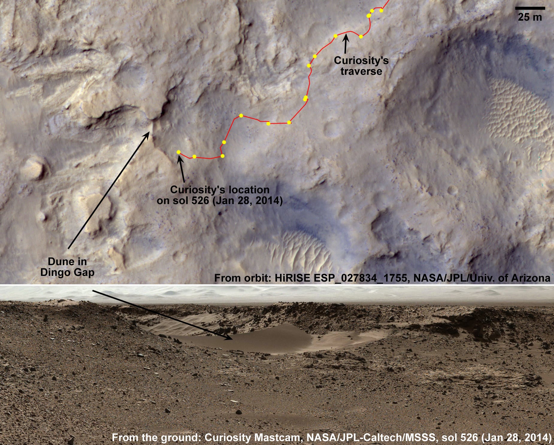
Thanks to the Mars Reconnaissance Orbiter and the HiRISE camera, we have an orbital view of Dingo Gap, an opening between two low scarps which is spanned by a single dune. This gap and dune are visible both from the ground and from orbit. The Curiosity Mars rover
has now crossed the gap
and is continuing its travels toward enticing science destinations, including interesting veins and mineral fractures.
In the orbital image from HiRISE, the rover itself is not in this image as it was acquired before MSL landed. However, the imagery was likely used to help the rover team decide on the way to travel.
Below are more images of Dingo gap before and after the rover plowed its way through the sand.
[caption id="attachment_109321" align="aligncenter" width="580"]
The Curiosity rover looks back at the tracks it left after crossing through the Dingo Gap sand dune. Credit: NASA/JPL, Caltech. Via Doug Ellison on Twitter. [/caption]
[caption width="600" align="aligncenter"]

The series of nine images making up this animation were taken by the rear Hazard-Avoidance Camera (rear Hazcam) on NASA's Curiosity Mars rover as the rover drove over a dune spanning "Dingo Gap" on Mars. Image credit: NASA/JPL-Caltech [/caption]
[caption id="attachment_109322" align="aligncenter" width="580"]
The orbital view of Gale Crater and the Dingo Gap region. Credit: NASA/JPL/University of Arizona.[/caption]
[caption id="attachment_109172" align="aligncenter" width="497"]
Curiosity looks back to 'Dingo Gap' sand dune after crossing over, backdropped by Mount Sharp on Sol 535, Feb. 5, 2014. Hazcam fisheye image linearized and colorized. Credit: NASA/JPL/Marco Di Lorenzo/Ken Kremer- kenkremer.[/caption]
[caption id="attachment_109159" align="aligncenter" width="580"] Curiosity's view to valley beyond after crossing over 'Dingo Gap' sand dune. This photomosaic was taken after Curiosity drove over the 1 meter tall Dingo Gap sand dune and shows dramatic scenery in the valley beyond, back dropped by eroded rim of Gale Crater. Assembled from navigation camera (navcam) raw images from Sol 535 (Feb. 6, 2104) Credit: NASA/JPL-Caltech/Ken Kremer- kenkremer.com/Marco Di Lorenzo[/caption]