A new satellite map from Google and
Digital Globe
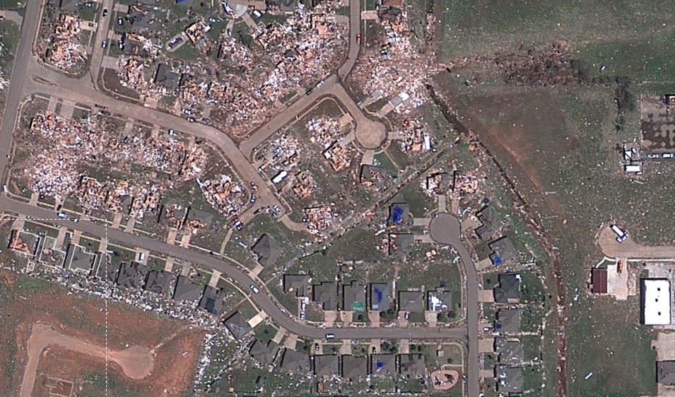
shows just-released satellite imagery of the damage from the tornado that struck the area of Moore, Oklahoma on May 20, 2013. It's been called one of the most powerful and destructive tornadoes ever recorded -- determined to be an EF5 tornado, the strongest rating for a tornado -- and the destruction is heartbreaking. In the screenshot above, you can see how some houses were left undamaged, while others were completely destroyed.
Click on the image above to have access to an
interactive map
that shows hi-resolution views of the damage, providing details of where the buildings and houses once were.
NPR
put this map together, using satellite data from Digital Globe, along with property data from City of Oklahoma City, City of Moore, and Cleveland County. Satellite data like this are helping to assist the recovery and rescue teams on the ground.
In the immediate aftermath of a natural catastrophe such as this tornado, the priority is searching for survivors and saving lives.
But longer term recovery — including the rebuilding of infrastructure and amenities such as schools and hospitals — can take decades, and satellite imagery can provide a systematic approach to aiding, monitoring and evaluating this process.
[caption id="attachment_102381" align="aligncenter" width="580"]
Satellite view of the destructive tornado that passed just south of Oklahoma City. The Moderate Resolution Imaging Spectroradiometer (MODIS) on NASA's Aqua satellite acquired this image of the storm at 2:40 p.m. local time (19:40 UTC) on May 20, 2013. Credit: NASA image courtesy Jeff Schmaltz, LANCE/EOSDIS MODIS Rapid Response Team at NASA GSFC. [/caption]
See more satellite views from NASA of the storm and aftermath on
NASA Goddard's Flickr page for this tornado.
The
Take Part website
has a list of organizations that are providing support for the recovery and care of the people affected, if you would like to contribute.